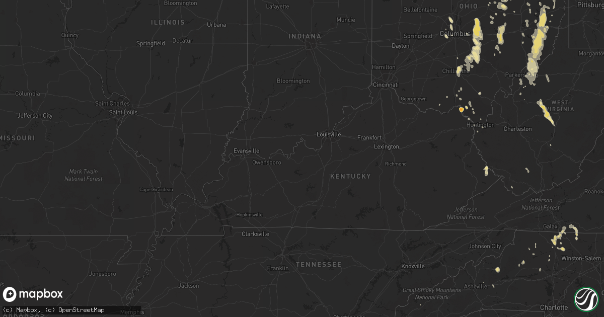
Hail Map in Mississippi on June 7, 2011
Get this storm
June 7 map
$229
one time, instant access
Download today. No call, no setup
Keep the $229
Bought the map and want the full workflow? Apply the entire $229 to a subscription within 7 days. None of it is wasted.
Every map, not just this one
This buys you this map. Subscription and you get every map we run, in the markets you choose from a few cities to whole states to nationwide. Plus real-time alerts the moment a storm fires.
Contact data
Name, contact info, occupancy, even credit band for addresses in the footprint. You go from where it hit to who to call.
Become the source they trust
Unlimited branding weather history reports on demand. You already have the documented answer ready for the property owner, and you are the one who showed up with it.
Property data and RoofTrace estimates
Pull up any address you have got, its value and the exact code rules for that jurisdiction, straight from One Click Code. Then RoofTrace estimates the squares, pitch, and roof value, priced the way you price.
Storm reports in Mississippi
Mississippi
| Date | Description |
|---|---|
| 06/07/20116:37 PM CDT | A local report indicates 1.50 inch wind near MADDEN |
| 06/07/20116:23 PM CDT | A large tree was also blown down in the yard off branson rd. |
| 06/07/20116:10 PM CDT | Light pole snapped and transformers on fire at old hillsboro road and hillsboro vfw road. |
| 06/07/20115:45 PM CDT | Powerlines down at the intersection of oak street and bush road. |
| 06/07/20115:40 PM CDT | Large tree down on livingston rd. |
| 06/07/20115:35 PM CDT | Tree fell onto a house at the intersection of 37th avenue and 20th street. Trees fell on powerlines on 4100 40th street and the intersection of 23rd avenue and 23rd str |
| 06/07/20115:33 PM CDT | Many large limbs down as well. |
| 06/07/20115:25 PM CDT | A local report indicates 1.75 inch wind near 2 SW TYLERTOWN |
| 06/07/20115:10 PM CDT | Tree down and powerlines down on 108 prescott drive. |
| 06/07/20115:10 PM CDT | Tree reported down on highway 18 and west sunset drive. |
| 06/07/20114:35 PM CDT | Tree reported down on county road 280. |
| 06/07/20114:33 PM CDT | A couple trees down around edwards |
| 06/07/20114:25 PM CDT | Trees down off athens rd. |
| 06/07/20114:20 PM CDT | Trees down along airport rd |
| 06/07/20114:15 PM CDT | Tree downed across highway 80 in rankin county just before hinds county line. |
| 06/07/20114:15 PM CDT | Trees downed old brandon road and whisper oak crossing. |
| 06/07/20114:15 PM CDT | Few trees down near tilton. |
| 06/07/20114:11 PM CDT | Quarter sized hail reported along varner road. |
| 06/07/20114:05 PM CDT | Two reports hail near the roxie community...quarter to golf ball size |
| 06/07/20114:00 PM CDT | Powerlines down at i-220 overpass at livingston road |
| 06/07/20114:00 PM CDT | Quarter sized hail reported along garner road near the simpson county/jefferson davis county line. |
| 06/07/20113:57 PM CDT | A local report indicates 1.00 inch wind near 1 W KIRBY |
| 06/07/20113:55 PM CDT | Power pole and lines down near ellis ave |
| 06/07/20113:55 PM CDT | Several trees down on pierce road to the west of highway 49 |
| 06/07/20113:50 PM CDT | A few power lines down along mcnair rd. |
| 06/07/20113:48 PM CDT | A local report indicates 1.00 inch wind near MCLAURIN |
| 06/07/20113:46 PM CDT | A local report indicates 1.75 inch wind near 4 NW BROOKLYN |
| 06/07/20113:45 PM CDT | Trees down old brandon road at rose garden...old brandon road at crestview and highway 80 at pirates cove. |
| 06/07/20113:43 PM CDT | Along oak grove rd |
| 06/07/20113:40 PM CDT | A few trees were down |
| 06/07/20113:40 PM CDT | Powerlines down at the intersection of oak street and bush road. |
| 06/07/20113:34 PM CDT | A couple trees down |
| 06/07/20113:30 PM CDT | Power lines down at camp shelby |
| 06/07/20113:29 PM CDT | A few trees down |
| 06/07/20113:29 PM CDT | On mccarty ln |
| 06/07/20113:02 PM CDT | A couple trees down |
| 06/07/20112:55 PM CDT | A few trees down off hwy 28. |
| 06/07/20112:53 PM CDT | 62 mph wind gust measured at bobby l. Chain airport. |
| 06/07/20112:45 PM CDT | 2 trees down on john evan road |
| 06/07/20112:44 PM CDT | Couple trees down off hwy 28 |
| 06/07/20112:40 PM CDT | Oak tree reported blown down on bay street that took out a powerline. Dime to penny size hail also observed. |
| 06/07/20112:35 PM CDT | Powerlines down. Broadcast media reports much of city without power. |
| 06/07/20112:22 PM CDT | Tree down on roy tucker roads and several trees down john odom road |
| 06/07/20112:20 PM CDT | Minor damage to police/fire training academy. Some power outages. |
| 06/07/20111:44 PM CDT | Couple trees down off hwy 28 |
| 06/06/20117:55 PM CDT | Shingles were pealed off a roof and lawn furniture was blown across the yard...dime hail also occurred. |
All States Impacted by Hail Map on June 7, 2011
Cities Impacted by Hail Map on June 7, 2011
- Mendenhall, MS
- Magee, MS
- Wakeman, OH
- Crestview, FL
- Indianola, MS
- Old Town, FL
- Jerusalem, OH
- Barnesville, OH
- Russell, KY
- Ashland, KY
- Creola, AL
- Frisco City, AL
- Monroeville, AL
- Norton, VA
- Appalachia, VA
- Big Stone Gap, VA
- Hattiesburg, MS
- Grove Hill, AL
- Millersburg, MI
- Hawks, MI
- Hebron, OH
- Granville, OH
- Lancaster, OH
- Logan, OH
- Rockbridge, OH
- Sugar Grove, OH
- Philo, OH
- Roseville, OH
- Zanesville, OH
- Nashport, OH
- Dresden, OH
- Adamsville, OH
- Blue Rock, OH
- Westfield Center, OH
- Lodi, OH
- Lorain, OH
- Elyria, OH
- Vermilion, OH
- Spencer, OH
- Seville, OH
- Sterling, OH
- Chippewa Lake, OH
- Grafton, OH
- Oberlin, OH
- Columbia Station, OH
- Berlin Heights, OH
- Rittman, OH
- Burbank, OH
- Medina, OH
- Wellington, OH
- Kipton, OH
- Wadsworth, OH
- North Ridgeville, OH
- Wooster, OH
- Creston, OH
- Smithville, OH
- Litchfield, OH
- Valley City, OH
- Lagrange, OH
- Amherst, OH
- Chunchula, AL
- Citronelle, AL
- Dodgeville, WI
- Big Falls, MN
- Ely, MN
- Castleberry, AL
- Brewton, AL
- Boonville, NC
- East Bend, NC
- Dobson, NC
- Baker, LA
- Fredonia, NY
- Mount Airy, NC
- New Orleans, LA
- Wagarville, AL
- Spruce Pine, NC
- Kalona, IA
- Fayette, MS
- Fruitdale, AL
- State Line, MS
- Gilbert, MN
- Kelliher, MN
- Richfield, WI
- Hartford, WI
- Slinger, WI
- Hubertus, WI
- Magnolia, MS
- Thomasville, AL
- Coffeeville, AL
- Denham Springs, LA
- Walker, LA
- Goetzville, MI
- De Tour Village, MI
- Hibbing, MN
- Mountain Iron, MN
- Richardton, ND
- Glen Ullin, ND
- Hebron, ND
- New Salem, ND
- Gainestown, AL
- Baskin, LA
- Sontag, MS
- Monticello, MS
- Horseshoe Beach, FL
- Monticello, FL
- Hazelton, ND
- State Road, NC
- Elkin, NC
- Lowgap, NC
- Thurmond, NC
- Tallulah, LA
- Chatom, AL
- Middlefield, OH
- Onaway, MI
- Cheboygan, MI
- Bristol, VA
- Lebanon, VA
- Abingdon, VA
- Defuniak Springs, FL
- Langdon, ND
- Little River, AL
- Jackson, AL
- Grove City, OH
- Galloway, OH
- Canton, MS
- Taylor, ND
- Eight Mile, AL
- Sunflower, AL
- Tibbie, AL
- Leroy, AL
- Saraland, AL
- Franklin, AL
- Whatley, AL
- Flomaton, AL
- Jay, FL
- Deer Park, AL
- Atmore, AL
- Uriah, AL
- McIntosh, AL
- Richton, MS
- Greenup, KY
- Tylertown, MS
- Franklinton, LA
- Roxie, MS
- Marianna, FL
- Beaver, OH
- Waverly, OH
- Livingston, LA
- Union Mills, NC
- Bethesda, OH
- Graysville, OH
- Lewisville, OH
- Lower Salem, OH
- Quaker City, OH
- Woodsfield, OH
- Beallsville, OH
- Moran, MI
- Saint Ignace, MI
- Kintyre, ND
- Braddock, ND
- Arnoldsburg, WV
- Pickford, MI
- Barbeau, MI
- Blountstown, FL
- South Shore, KY
- Panama City, FL
- Union, MS
- Dafter, MI
- Apple Creek, OH
- Dalton, OH
- Millersburg, OH
- Fredericksburg, OH
- Holmesville, OH
- Woodville, MS
- Crosby, MS
- Gloster, MS
- Mansfield, LA
- Galena, IL
- Finland, MN
- Cook, MN
- Tower, MN
- Morton, MS
- Pulaski, MS
- Dunkirk, NY
- Forest Hills, KY
- South Williamson, KY
- Huddy, KY
- Canada, KY
- Stone, KY
- Williamson, WV
- Belfry, KY
- Walker, WV
- Davisville, WV
- Parkersburg, WV
- New London, OH
- Nova, OH
- Sullivan, OH
- Herron, MI
- Hillman, MI
- Atlanta, MI
- Lachine, MI
- Minford, OH
- Portsmouth, OH
- Corning, OH
- Crooksville, OH
- Sinclairville, NY
- Cherry Creek, NY
- Prentiss, MS
- Newhebron, MS
- Mount Olive, MS
- Northport, MI
- Holt, FL
- Moffit, ND
- Cadiz, OH
- Cassadaga, NY
- Sheridan, NY
- Forestville, NY
- Silver Creek, NY
- Meadows Of Dan, VA
- Willis, VA
- Greensburg, LA
- Pascagoula, MS
- Moss Point, MS
- Bay City, TX
- Reedy, WV
- North Bloomfield, OH
- Bristolville, OH
- Orwell, OH
- Claudville, VA
- Ararat, VA
- Hillsville, VA
- Stuart, VA
- Westfield, NC
- Purvis, MS
- Wingett Run, OH
- New Matamoras, OH
- Summerfield, OH
- Carthage, MS
- Philadelphia, MS
- Walnut Grove, MS
- Houston, TX
- Franklin Furnace, OH
- Wheelersburg, OH
- Catlettsburg, KY
- Rush, KY
- Reynoldsburg, OH
- Pickerington, OH
- Pataskala, OH
- Sandy Hook, MS
- Babbitt, MN
- Embarrass, MN
- Petal, MS
- West Salem, OH
- Orrville, OH
- Milton, FL
- Olive Hill, KY
- Millry, AL
- Leakesville, MS
- Waynesboro, MS
- Buckatunna, MS
- Brimson, MN
- Hoyt Lakes, MN
- Burkeville, TX
- Wiergate, TX
- Sidney, KY
- Waverly, WV
- Newport, OH
- Marietta, OH
- Saint Marys, WV
- Whipple, OH
- Reno, OH
- Belmont, WV
- Winnsboro, LA
- Coeburn, VA
- Dungannon, VA
- Atwater, OH
- Baker, FL
- Harbor Springs, MI
- Carp Lake, MI
- Levering, MI
- Coshocton, OH
- Lisbon, OH
- Delhi, LA
- Crane Lake, MN
- Meridian, MS
- Chardon, OH
- Burton, OH
- Uhrichsville, OH
- Dennison, OH
- New Philadelphia, OH
- Midvale, OH
- Newbury, OH
- Chagrin Falls, OH
- Hiram, OH
- Argillite, KY
- Wise, VA
- Millersport, OH
- Baltimore, OH
- Pleasantville, OH
- Bremen, OH
- Rushville, OH
- Thurston, OH
- Powell, OH
- Delaware, OH
- Rayville, LA
- Mangham, LA
- Foxworth, MS
- Oak Grove, LA
- Mer Rouge, LA
- New Augusta, MS
- Mount Hermon, LA
- Silver Creek, MS
- Freeport, OH
- Flushing, OH
- Independence, LA
- Tickfaw, LA
- Beloit, OH
- North Canton, OH
- Canton, OH
- Hartville, OH
- Uniontown, OH
- Middlebranch, OH
- Jeffersonville, KY
- Mount Sterling, KY
- Sparta, WI
- Tomah, WI
- Angora, MN
- South Point, OH
- Kenova, WV
- Ashland, OH
- Navarre, OH
- Dundee, OH
- Olmsted Falls, OH
- North Olmsted, OH
- Polk, OH
- Shreve, OH
- Avon Lake, OH
- Sheffield Lake, OH
- Huron, OH
- Greenwich, OH
- Bay Village, OH
- Marshallville, OH
- Westlake, OH
- Brunswick, OH
- Avon, OH
- Homerville, OH
- Akron, OH
- Mount Eaton, OH
- Hazlehurst, MS
- Newellton, LA
- Duffield, VA
- Old Fort, NC
- North Lawrence, OH
- Canal Fulton, OH
- Warren, OH
- Lake Milton, OH
- Newton Falls, OH
- North Jackson, OH
- Diamond, OH
- Watertown, WI
- Sullivan, WI
- Ravenna, OH
- Random Lake, WI
- South Dayton, NY
- Cattaraugus, NY
- Conewango Valley, NY
- Port O'Connor, TX
- Port Lavaca, TX
- Cedar Key, FL
- Lenoir, NC
- Saint Amant, LA
- Gramercy, LA
- Salem, OH
- Clinton, LA
- Brockton, MT
- Laurelville, OH
- Amanda, OH
- Sandy Hook, KY
- Grayson, KY
- Cana, VA
- Belmont, OH
- Saint Clairsville, OH
- Blissfield, OH
- Killbuck, OH
- Warsaw, OH
- Norwood, LA
- Wilson, LA
- Newark, OH
- Utica, OH
- Raysal, WV
- Ivanhoe, VA
- Jewett, OH
- Meadville, MS
- Alpena, MI
- Pledger, TX
- Winchester, KY
- Pickens, MS
- Baudette, MN
- Fox Lake, WI
- Burnett, WI
- Beaver Dam, WI
- Summit, MS
- Bogue Chitto, MS
- Ruth, MS
- Posen, MI
- Mantua, OH
- Aurora, OH
- Streetsboro, OH
- Grand Cane, LA
- Loudonville, OH
- Lakeville, OH
- Pinola, MS
- Rio, WI
- Inverness, MS
- Leland, MS
- Kensington, OH
- Mechanicstown, OH
- Salineville, OH
- Carrollton, OH
- Scio, OH
- Bowerston, OH
- Huntington, WV
- Nallen, WV
- Mendota, VA
- Orma, WV
- South Webster, OH
- Pedro, OH
- Port Saint Joe, FL
- Menoken, ND
- Steele, ND
- Edwards, MS
- Lumberton, MS
- Britt, MN
- Jackson, WI
- West Bend, WI
- Clarksville, FL
- Altha, FL
- Chloe, WV
- Nebo, WV
- Ivydale, WV
- Dille, WV
- Clay, WV
- Duck, WV
- Rosedale, WV
- Frametown, WV
- Dover, OH
- Mineral City, OH
- Zoar, OH
- Bolivar, OH
- Taylorsville, NC
- Hiddenite, NC
- Gretna, LA
- Laurel, MS
- Bismarck, ND
- Dawson, ND
- Owingsville, KY
- Presque Isle, MI
- Rogers City, MI
- Johannesburg, MI
- Camden, MS
- Pelahatchie, MS
- Littlefork, MN
- Fresno, OH
- Newcomerstown, OH
- Brandon, MS
- Shubuta, MS
- Vossburg, MS
- Baton Rouge, LA
- Senecaville, OH
- Byesville, OH
- Saint Bernard, LA
- Elizabeth, WV
- Forest, MS
- Irving, NY
- Adena, OH
- Norwalk, OH
- Ronda, NC
- Twinsburg, OH
- Hudson, OH
- Massillon, OH
- Clinton, OH
- Novelty, OH
- Chesterland, OH
- Garrettsville, OH
- Black Mountain, NC
- Glenmont, OH
- Big Prairie, OH
- Vinton, OH
- Thurman, OH
- Robbinsville, NC
- Maben, WV
- Mullens, WV
- Saulsville, WV
- Napoleon, ND
- Lost Nation, IA
- Satsuma, AL
- Axis, AL
- Thornville, OH
- Johnstown, OH
- Buckeye Lake, OH
- Heath, OH
- Dugspur, VA
- Laurel Fork, VA
- Harrisville, WV
- Pullman, WV
- Pennsboro, WV
- Mineral Point, WI
- Fries, VA
- Osyka, MS
- Mccomb, MS
- Helenville, WI
- Jacksontown, OH
- Alexandria, OH
- Millstone, WV
- Mount Zion, WV
- Monroe, WI
- Juda, WI
- Sondheimer, LA
- Mayville, WI
- Brownsville, WI
- Lomira, WI
- Kokomo, MS
- Stout, OH
- Isabella, MN
- Chillicothe, OH
- New Lexington, OH
- Kent, OH
- Murphy, NC
- Raleigh, MS
- Quitman, MS
- Chisholm, MN
- Farmdale, OH
- Semmes, AL
- Petoskey, MI
- Pearl, MS
- Fall River, WI
- Marion, NC
- Seminary, MS
- Collins, MS
- Southington, OH
- Union Church, MS
- Virginia, MN
- Portage, WI
- Repton, AL
- Kinross, MI
- Rudyard, MI
- Newberry, MI
- Marshall, WI
- Sun Prairie, WI
- Sugarcreek, OH
- Chatham, LA
- Bottineau, ND
- Souris, ND
- Columbus, OH
- Randolph, NY
- Kennedy, NY
- Gerry, NY
- Fort Blackmore, VA
- Gate City, VA
- Cedarville, MI
- Sandyville, WV
- Le Roy, WV
- Walhonding, OH
- Frazeysburg, OH
- Randolph, WI
- Markesan, WI
- Cambria, WI
- Danville, OH
- Naubinway, MI
- Banks, AR
- Sault Sainte Marie, MI
- Goodman, MS
- Slaughter, LA
- Stow, OH
- Centreville, MS
- Dublin, OH
- Lore City, OH
- Kimbolton, OH
- Salesville, OH
- Richfield, OH
- Orr, MN
- Wewahitchka, FL
- Doylestown, OH
- Barberton, OH
- Ixonia, WI
- Neosho, WI
- Oconomowoc, WI
- Oak Vale, MS
- Laurel Hill, FL
- Poynette, WI
- Brinkhaven, OH
- Jayess, MS
- Jones, LA
- Scales Mound, IL
- Belgium, WI
- Fredonia, WI
- Suttons Bay, MI
- Lena, MS
- Mineral Wells, WV
- Rockport, WV
- Lenox, AL
- Williamstown, WV
- Petroleum, WV
- Converse, LA
- Hitchins, KY
- Andalusia, AL
- Caldwell, OH
- Sarahsville, OH
- El Dorado, AR
- Castlewood, VA
- Winton, MN
- Saukville, WI
- Wilkesboro, NC
- Millers Creek, NC
- Purlear, NC
- South Bloomingville, OH
- Drummond Island, MI
- Hessel, MI
- Leavittsburg, OH
- Malcom, IA
- Tama, IA
- Lynn Haven, FL
- Amite, LA
- Tippecanoe, OH
- Greenwell Springs, LA
- Almont, ND
- Apalachicola, FL
- Fort Atkinson, WI
- Peosta, IA
- Ponemah, MN
- Fond Du Lac, WI
- Oakfield, WI
- Waupun, WI
- Pointe Aux Pins, MI
- Otway, OH
- Macedonia, OH
- Northfield, OH
- Edgerton, WI
- Magnolia, OH
- Dellroy, OH
- McGrady, NC
- Mandan, ND
- Kingston, OH
- Lucasville, OH
- Biwabik, MN
- Windham, OH
- West Farmington, OH
- La Marque, TX
- Brooklyn, IA
- Hartwick, IA
- Cortland, OH
- Mackinaw City, MI
- Indian Valley, VA
- Hampton, AR
- Little Rock, MS
- Chunky, MS
- Grygla, MN
- Sweet Water, AL
- Hiwassee, VA
- Tallmadge, OH
- Malta, OH
- Lake, MS
- Berlin Center, OH
- Canfield, OH
- Hamburg, AR
- Hopedale, OH
- Piedmont, OH
- Cairo, WV
- Alledonia, OH
- Morristown, OH
- Dexter City, OH
- Macfarlan, WV
- Macksburg, OH
- Port Washington, OH
- Ethel, LA
- Bloomingdale, OH
- Richmond, OH
- Bergholz, OH
- Hammondsville, OH
- Irondale, OH
- Flatwoods, KY
- Denton, KY
- Vaughan, MS
- Adelphi, OH
- Londonderry, OH
- Kirkersville, OH
- Kentwood, LA
- Warren, AR
- Waskish, MN
- Rootstown, OH
- Platteville, WI
- Bowbells, ND
- Chiefland, FL
- Hilliard, OH
- Hinckley, OH
- Danbury, TX
- Union Grove, NC
- North Wilkesboro, NC
- Wing, AL
- Stockton, AL
- Belleville, WV
- Willoughby, OH
- Mentor, OH
- Huntsburg, OH
- Kimper, KY
- McAndrews, KY
- Decatur, MS
- Circleville, OH
- Chesapeake, OH


