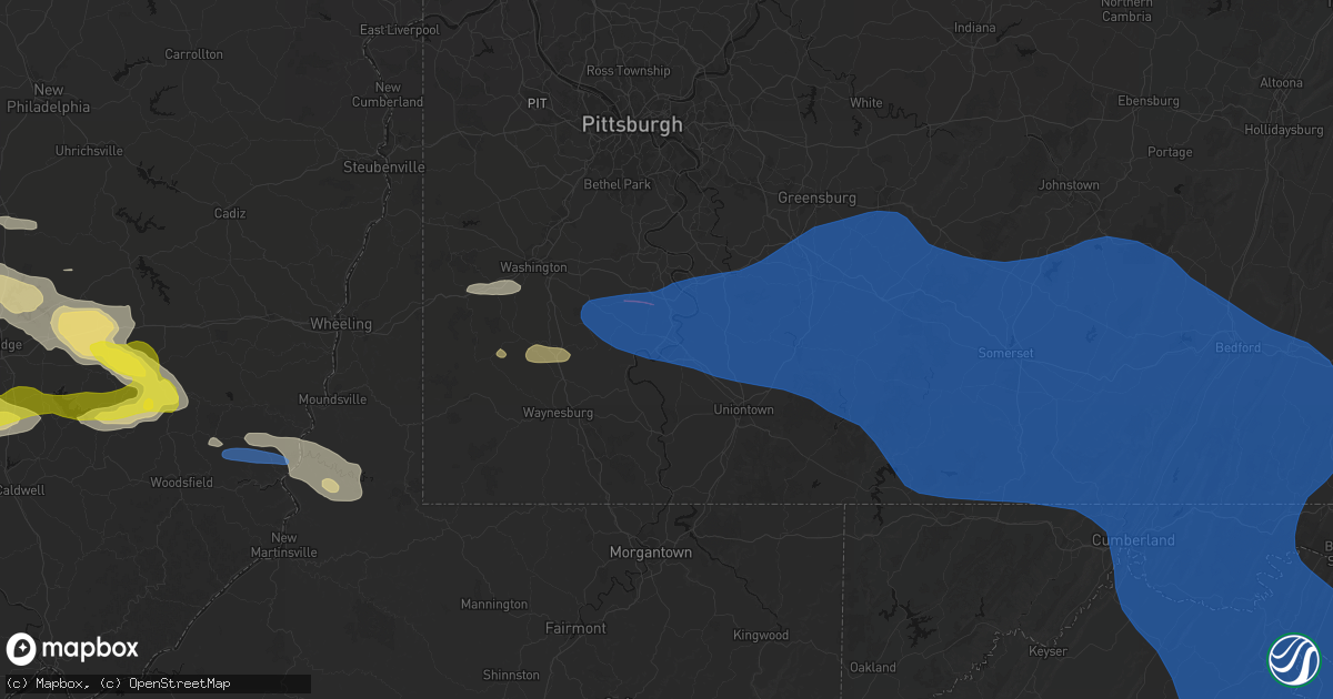
Hail Map in Brownsville, PA on June 6, 2026
Get this storm
June 6 map
$229
one time, instant access
Download today. No call, no setup
Keep the $229
Bought the map and want the full workflow? Apply the entire $229 to a subscription within 7 days. None of it is wasted.
Every map, not just this one
This buys you this map. Subscription and you get every map we run, in the markets you choose from a few cities to whole states to nationwide. Plus real-time alerts the moment a storm fires.
Contact data
Name, contact info, occupancy, even credit band for addresses in the footprint. You go from where it hit to who to call.
Become the source they trust
Unlimited branding weather history reports on demand. You already have the documented answer ready for the property owner, and you are the one who showed up with it.
Property data and RoofTrace estimates
Pull up any address you have got, its value and the exact code rules for that jurisdiction, straight from One Click Code. Then RoofTrace estimates the squares, pitch, and roof value, priced the way you price.
Storm reports in Brownsville, PA
Brownsville, PA
| Date | Description |
|---|---|
| 06/06/20261:50 PM CDT | Tree down on vehicle on brownsville road. |
| 06/06/20261:50 PM CDT | Tree down across the road near intersection of bull run road and porter road. Time estimated via radar. |
| 06/06/20261:49 PM CDT | Videos and images posted on facebook of snapped and uprooted trees from ryes bar & grill |
All States Impacted by Hail Map on June 6, 2026
All Cities Impacted by Hail Map on June 6, 2026
- Battle Ground, IN
- West Lafayette, IN
- Lafayette, IN
- Delphi, IN
- Frankfort, IN
- Cutler, IN
- Luverne, ND
- Hannaford, ND
- Marion, IN
- Upland, IN
- Fowlerton, IN
- Gas City, IN
- Fairmount, IN
- Gaston, IN
- Swayzee, IN
- Summitville, IN
- Jonesboro, IN
- Cloverdale, OH
- Kenton, OH
- Belle Center, OH
- Lakeview, OH
- Russells Point, OH
- Huntsville, OH
- Bellefontaine, OH
- Rushsylvania, OH
- Richwood, OH
- Marysville, OH
- Raymond, OH
- Delaware, OH
- Sunbury, OH
- Marengo, OH
- Ashley, OH
- Cardington, OH
- Columbus, OH
- Dublin, OH
- Newark, OH
- Frazeysburg, OH
- Saint Louisville, OH
- Nashport, OH
- Merkel, TX
- Dresden, OH
- Trinway, OH
- Anson, TX
- Andover, OH
- Williamsfield, OH
- Jamestown, PA
- Adamsville, OH
- Townville, PA
- Centerville, PA
- Meadville, PA
- Cochranton, PA
- Guys Mills, PA
- Newcomerstown, OH
- Norwich, OH
- Zanesville, OH
- New Concord, OH
- Titusville, PA
- Hartstown, PA
- Hawley, TX
- Abilene, TX
- Avoca, TX
- Stamford, TX
- Lueders, TX
- Albany, TX
- Ellsworth, PA
- Bentleyville, PA
- Coal Center, PA
- Glen Campbell, PA
- Otterbein, IN
- Baird, TX
- Westpoint, IN
- Marion Center, PA
- Rochester Mills, PA
- Charleroi, PA
- Daisytown, PA
- Fredericktown, PA
- Brownsville, PA
- East Millsboro, PA
- Grindstone, PA
- Hiller, PA
- California, PA
- Allison, PA
- Smock, PA
- New Salem, PA
- Newell, PA
- Fayette City, PA
- Allenport, PA
- Monessen, PA
- Belle Vernon, PA
- Elco, PA
- Roscoe, PA
- Stockdale, PA
- Dunlevy, PA
- Earl Park, IN
- Fowler, IN
- Hillsdale, PA
- Cisco, TX
- Moran, TX
- Cherry Tree, PA
- Ridgway, PA
- Star Junction, PA
- Keisterville, PA
- Waltersburg, PA
- West Leisenring, PA
- Uniontown, PA
- Mount Braddock, PA
- Dunbar, PA
- Vanderbilt, PA
- Perryopolis, PA
- Lemont Furnace, PA
- Smithton, PA
- Wickhaven, PA
- Dawson, PA
- Mill Run, PA
- Dickerson Run, PA
- Connellsville, PA
- Ohiopyle, PA
- Mount Pleasant, PA
- Everson, PA
- Scottdale, PA
- New Stanton, PA
- Alverton, PA
- Hunker, PA
- Tarrs, PA
- Ruffs Dale, PA
- Brockport, PA
- Confluence, PA
- Acme, PA
- Normalville, PA
- White, PA
- Greensburg, PA
- Indian Head, PA
- Rockwood, PA
- Stahlstown, PA
- Pleasant Unity, PA
- Latrobe, PA
- Melcroft, PA
- Champion, PA
- Donegal, PA
- Youngwood, PA
- Cokeburg, PA
- Scenery Hill, PA
- Eighty Four, PA
- Richeyville, PA
- Beallsville, PA
- Marianna, PA
- Denbo, PA
- Vestaburg, PA
- La Belle, PA
- Merrittstown, PA
- Hostetter, PA
- Jones Mills, PA
- Breckenridge, TX
- Addison, PA
- Ligonier, PA
- Markleton, PA
- Fort Hill, PA
- Somerset, PA
- Laughlintown, PA
- Hidden Valley, PA
- Rector, PA
- Newcastle, TX
- Olney, TX
- Saint Joseph, MO
- Loving, TX
- Salisbury, PA
- Boynton, PA
- West Salisbury, PA
- Springs, PA
- Garrett, PA
- Meyersdale, PA
- Berlin, PA
- Buffalo Mills, PA
- Hyndman, PA
- Bedford, PA
- Fairhope, PA
- Friedens, PA
- Acosta, PA
- Gray, PA
- Boswell, PA
- Quecreek, PA
- Stoystown, PA
- Hooversville, PA
- Shanksville, PA
- Schellsburg, PA
- Jenners, PA
- Cairnbrook, PA
- Manns Choice, PA
- Davidsville, PA
- Hollsopple, PA
- Seanor, PA
- Jerome, PA
- Windber, PA
- Central City, PA
- Jennerstown, PA
- Mill Hall, PA
- Loganton, PA
- Lock Haven, PA
- Rebersburg, PA
- Jacksboro, TX
- Windthorst, TX
- New Paris, PA
- Fishertown, PA
- Alum Bank, PA
- Maysville, MO
- Axtell, KS
- Baileyville, KS
- Roaring Branch, PA
- Ralston, PA
- Trout Run, PA
- Rensselaer, IN
- Henrietta, TX
- Wiley Ford, WV
- Mount Savage, MD
- Wellersburg, PA
- Ellerslie, MD
- Cumberland, MD
- Corriganville, MD
- Frostburg, MD
- Ridgeley, WV
- Oldtown, MD
- Flintstone, MD
- Everett, PA
- Artemas, PA
- Clearville, PA
- Mifflinburg, PA
- Laurelton, PA
- Allenwood, PA
- Lewisburg, PA
- New Columbia, PA
- Roscoe, NY
- Amity, MO
- Urbana, OH
- Fort Loudon, PA
- Spickard, MO
- North Lewisburg, OH
- Cable, OH
- Woodstock, OH
- Sabetha, KS
- Equinunk, PA
- Long Eddy, NY
- Hankins, NY
- Mechanicsburg, OH
- Milford Center, OH
- Milton, PA
- Selinsgrove, PA
- Shamokin Dam, PA
- New Berlin, PA
- Winfield, PA
- West Milton, PA
- Montandon, PA
- Danville, PA
- Northumberland, PA
- Fort Ashby, WV
- Springfield, WV
- Green Spring, WV
- Breezewood, PA
- Crystal Spring, PA
- Warfordsburg, PA
- Great Cacapon, WV
- Hancock, MD
- Levels, WV
- Little Orleans, MD
- Romney, WV
- Slanesville, WV
- Paw Paw, WV
- Points, WV
- Augusta, WV
- Berkeley Springs, WV
- Middleburg, PA
- Saint Thomas, PA
- Chambersburg, PA
- Galt, MO
- Rome, PA
- Parksville, NY
- Liberty, NY
- Callicoon, NY
- North Branch, NY
- Fremont Center, NY
- Irwin, OH
- London, OH
- Plain City, OH
- Rossburg, OH
- New Weston, OH
- Upperstrasburg, PA
- Springer, NM
- Thorntown, IN
- Brownwood, TX
- Colfax, IN
- Burchard, NE
- Sunbury, PA
- Bloomsburg, PA
- Riverside, PA
- Paxinos, PA
- Port Trevorton, PA
- Dornsife, PA
- Herndon, PA
- Freeburg, PA
- Lykens, PA
- Dalmatia, PA
- Gratz, PA
- Elizabethville, PA
- Berrysburg, PA
- Jeffersonville, NY
- Swan Lake, NY
- White Sulphur Springs, NY
- Youngsville, NY
- Livingston Manor, NY
- Millerstown, PA
- Newport, PA
- Neversink, NY
- Woodbourne, NY
- Millersburg, PA
- Pillow, PA
- Mount Pleasant Mills, PA
- Saint Henry, OH
- Bloomery, WV
- Capon Bridge, WV
- Cross Junction, VA
- Martinsburg, WV
- Hedgesville, WV
- Inwood, WV
- Gerrardstown, WV
- Glengary, WV
- Winchester, VA
- High View, WV
- Gore, VA
- Pitman, PA
- Trevorton, PA
- Hegins, PA
- Shamokin, PA
- Catawissa, PA
- Rebuck, PA
- Klingerstown, PA
- Coal Township, PA
- Leck Kill, PA
- Elysburg, PA
- Kulpmont, PA
- Wilburton, PA
- Marion Heights, PA
- Mount Carmel, PA
- Locust Gap, PA
- Powell, OH
- Maryneal, TX
- Hurleyville, NY
- Ferndale, NY
- Grahamsville, NY
- Loch Sheldrake, NY
- Sacramento, PA
- Bridgeport, TX
- Springer, OK
- Davis, OK
- Robert Lee, TX
- New Bloomfield, PA
- Las Vegas, NM
- Halifax, PA
- Liverpool, PA
- Clarks Hill, IN
- Elliottsburg, PA
- Ostrander, OH
- Amlin, OH
- Lewis Center, OH
- Westerville, OH
- Clear Brook, VA
- Bunker Hill, WV
- Stephenson, VA
- Summit Point, WV
- Berryville, VA
- Kearneysville, WV
- Ashland, PA
- Ranson, WV
- Charles Town, WV
- Shenandoah Junction, WV
- Put In Bay, OH
- Duncannon, PA
- Stone Ridge, NY
- Cottekill, NY
- Accord, NY
- Kingston, NY
- Dillsburg, PA
- York Springs, PA
- East Berlin, PA
- Galena, OH
- Johnstown, OH
- Des Moines, NM
- Healdton, OK
- Lakeside Marblehead, OH
- Lancaster, OH
- Pleasantville, OH
- Wellsville, PA
- Blackwell, TX
- Tillson, NY
- Rosendale, NY
- Ulster Park, NY
- High Falls, NY
- New Paltz, NY
- Baltimore, OH
- Dauphin, PA
- Wilson, OK
- Ringling, OK
- New Albany, OH
- Highland, NY
- Hyde Park, NY
- Staatsburg, NY
- Poughkeepsie, NY
- Millersport, OH
- Bronte, TX
- Mount Perry, OH
- Justin, TX
- Rushville, OH
- Bremen, OH
- Pine Village, IN
- Sandusky, OH
- Decatur, TX
- Paradise, TX
- Galloway, OH
- West Liberty, OH
- De Graff, OH
- South Vienna, OH
- Bloomington, NY
- Pleasant Valley, NY
- Huron, OH
- Cheshire, MA
- Chandlersville, OH
- Blue Rock, OH
- Philo, OH
- Duncan Falls, OH
- Wingate, TX
- Ponder, TX
- Mullin, TX
- Milan, OH
- Salt Point, NY
- Delia, KS
- Emmett, KS
- Krum, TX
- Millersview, TX
- Zephyr, TX
- Early, TX
- Pittsfield, MA
- East Nassau, NY
- Stephentown, NY
- New Lebanon, NY
- Weatherford, TX
- Leon, OK
- Cumberland, OH
- Cambridge, OH
- Pleasant City, OH
- Byesville, OH
- Senecaville, OH
- Collins, OH
- Rowe, MA
- Adams, MA
- Savoy, MA
- Drury, MA
- Kimbolton, OH
- Freeport, OH
- Azle, TX
- Fort Worth, TX
- Quaker City, OH
- Salesville, OH
- Lore City, OH
- Gainesville, TX
- Muenster, TX
- Lindsay, TX
- Paint Rock, TX
- Orwell, VT
- Ticonderoga, NY
- Putnam Station, NY
- Burneyville, OK
- Attica, IN
- Williamsport, IN
- Tuscola, TX
- Romney, IN
- New Richmond, IN
- Barnesville, OH
- Conesville, OH
- Canal Winchester, OH
- Carroll, OH
- Brandon, VT
- Whiting, VT
- Summerfield, OH
- Wingate, IN
- Roy, NM
- Dublin, TX
- Ada, OK
- Haslet, TX
- Jerusalem, OH
- Trinidad, CO
- Model, CO
- Monroeville, OH
- Pittsford, VT
- Fair Haven, VT
- Hico, TX
- Coshocton, OH
- Deer Trail, CO
- Keller, TX
- Talpa, TX
- Goldthwaite, TX
- Priddy, TX
- Veedersburg, IN
- Gustine, TX
- Comanche, TX
- Hamilton, TX
- Villisca, IA
- Mosquero, NM
- Stephenville, TX
- Newtown, IN
- Hillsboro, IN
- Waynetown, IN
- Wakeman, OH
- New London, OH
- Wellington, OH
- Castleton, VT
- Florence, VT
- Mellott, IN
- Beallsville, OH
- Novice, TX
- Santa Anna, TX
- Bangs, TX
- Old Washington, OH
- Whitesboro, TX
- Nova, OH
- Sullivan, OH
- West Salem, OH
- Ashland, OH
- Corning, IA
- Nodaway, IA
- Cuervo, NM
- Ashville, OH
- Williamsport, OH
- Coleman, TX
- Tucumcari, NM
- Elliott, IA
- Carlton, TX
- Mount Sterling, OH
- Bomoseen, VT
- Pittsfield, VT
- Fort Morgan, CO
- Proctor, WV
- Clarington, OH
- Powhatan Point, OH
- Sadler, TX
- Polk, OH
- Stonewall, OK
- Allen, OK
- Washington, PA
- Claysville, PA
- West Alexander, PA
- West Finley, PA
- House, NM
- Griswold, IA
- Prosperity, PA
- Graysville, PA
- Circleville, OH
- Hot Springs, SD
- Cameron, WV
- Glen Easton, WV
- Moundsville, WV
- Moonachie, NJ
- Bronxville, NY
- Elmwood Park, NJ
- Montclair, NJ
- Hastings On Hudson, NY
- Little Falls, NJ
- Haworth, NJ
- Cresskill, NJ
- East Orange, NJ
- Carlstadt, NJ
- Leonia, NJ
- Ridgefield, NJ
- Closter, NJ
- Elizabeth, NJ
- Hasbrouck Heights, NJ
- Kearny, NJ
- Yonkers, NY
- Demarest, NJ
- Bogota, NJ
- Bronx, NY
- Bergenfield, NJ
- Hackensack, NJ
- Garfield, NJ
- Maywood, NJ
- Clifton, NJ
- Teterboro, NJ
- Fort Lee, NJ
- Wallington, NJ
- North Bergen, NJ
- Passaic, NJ
- Saddle Brook, NJ
- Alpine, NJ
- Eastchester, NY
- East Rutherford, NJ
- Englewood, NJ
- Englewood Cliffs, NJ
- River Edge, NJ
- Lodi, NJ
- Hillside, NJ
- Scarsdale, NY
- Teaneck, NJ
- New Milford, NJ
- White Plains, NY
- Rochelle Park, NJ
- Rutherford, NJ
- Hartsdale, NY
- Ardsley, NY
- Harrison, NJ
- Belleville, NJ
- Glen Ridge, NJ
- Paramus, NJ
- Tenafly, NJ
- Little Ferry, NJ
- West Harrison, NY
- Secaucus, NJ
- Wood Ridge, NJ
- Dumont, NJ
- Newark, NJ
- Ridgefield Park, NJ
- Lyndhurst, NJ
- Tuckahoe, NY
- Irvington, NJ
- Oradell, NJ
- Palisades Park, NJ
- Bloomfield, NJ
- South Hackensack, NJ
- Nutley, NJ
- North Arlington, NJ
- Paterson, NJ
- Fair Lawn, NJ
- Totowa, NJ
- Verona, NJ
- Orange, NJ
- Cedar Grove, NJ
- West Orange, NJ
- South Orange, NJ
- Union, NJ
- Maplewood, NJ
- Jersey City, NJ
- Union City, NJ
- Cliffside Park, NJ
- Fairview, NJ
- Weehawken, NJ
- Staten Island, NY
- West New York, NJ
- New York, NY
- Edgewater, NJ
- Elizabethport, NJ
- Astoria, NY
- Hoboken, NJ
- Long Island City, NY
- Mount Vernon, NY
- Bayonne, NJ
- New Rochelle, NY
- Brooklyn, NY
- Pelham, NY
- Sunnyside, NY
- Larchmont, NY
- Woodside, NY
- East Elmhurst, NY
- Flushing, NY
- Rye, NY
- Mamaroneck, NY
- Harrison, NY
- Maspeth, NY
- College Point, NY
- Middle Village, NY
- Corona, NY
- Elmhurst, NY
- Jackson Heights, NY
- Ridgewood, NY
- Ozone Park, NY
- Whitestone, NY
- Woodhaven, NY
- Rego Park, NY
- Forest Hills, NY
- Ossining, NY
- Pleasantville, NY
- Valhalla, NY
- Sparkill, NY
- Orangeburg, NY
- Tarrytown, NY
- Hawthorne, NY
- Briarcliff Manor, NY
- Elmsford, NY
- Harrington Park, NJ
- Blauvelt, NY
- Westwood, NJ
- Norwood, NJ
- Dobbs Ferry, NY
- Irvington, NY
- Emerson, NJ
- Nyack, NY
- Palisades, NY
- Piermont, NY
- Northvale, NJ
- Tappan, NY
- Valley Cottage, NY
- Congers, NY
- Croton On Hudson, NY
- Crawfordsville, IN
- Snyder, CO
- Nineveh, PA
- Sycamore, PA
- Amity, PA
- Waynesburg, PA
- Wilton, CT
- Bedford, NY
- New Canaan, CT
- Stamford, CT
- Chappaqua, NY
- Armonk, NY
- Thornwood, NY
- Katonah, NY
- South Salem, NY
- Greenwich, CT
- Pound Ridge, NY
- Purchase, NY
- Millwood, NY
- Port Chester, NY
- Mount Kisco, NY
- Bedford Hills, NY
- Ridgefield, CT
- Cross River, NY
- Yorktown Heights, NY
- Redding, CT
- Cos Cob, CT
- Elmont, NY
- Manhasset, NY
- Floral Park, NY
- Glen Cove, NY
- Kew Gardens, NY
- Albertson, NY
- Roosevelt, NY
- Garden City, NY
- Great Neck, NY
- Lynbrook, NY
- Sea Cliff, NY
- Glen Head, NY
- South Richmond Hill, NY
- Richmond Hill, NY
- Greenvale, NY
- Baldwin, NY
- Westbury, NY
- Jamaica, NY
- Rosedale, NY
- Locust Valley, NY
- Saint Albans, NY
- Uniondale, NY
- Freeport, NY
- Glen Oaks, NY
- Little Neck, NY
- Williston Park, NY
- Oyster Bay, NY
- Fresh Meadows, NY
- Howard Beach, NY
- South Ozone Park, NY
- Cambria Heights, NY
- Valley Stream, NY
- New Hyde Park, NY
- Hempstead, NY
- Port Washington, NY
- Rockville Centre, NY
- Bellerose, NY
- Bayside, NY
- Queens Village, NY
- Glenwood Landing, NY
- Oakland Gardens, NY
- Franklin Square, NY
- Mineola, NY
- Mill Neck, NY
- Far Rockaway, NY
- Malverne, NY
- West Hempstead, NY
- Bayville, NY
- Hollis, NY
- Roslyn, NY
- Springfield Gardens, NY
- Old Westbury, NY
- Carle Place, NY
- Roslyn Heights, NY
- West Lafayette, OH
- Fresno, OH
- West Nyack, NY
- Cold Spring Harbor, NY
- Levittown, NY
- Massapequa, NY
- Riverside, CT
- Hewlett, NY
- Cedarhurst, NY
- Old Greenwich, CT
- Darien, CT
- Melville, NY
- Oceanside, NY
- Huntington, NY
- Inwood, NY
- East Norwich, NY
- Norwalk, CT
- Bethpage, NY
- Old Bethpage, NY
- Farmingdale, NY
- Massapequa Park, NY
- Wantagh, NY
- Woodbury, NY
- Plainview, NY
- Lawrence, NY
- Merrick, NY
- Syosset, NY
- East Rockaway, NY
- Woodmere, NY
- Huntington Station, NY
- Hicksville, NY
- Bellmore, NY
- Weston, CT
- Seaford, NY
- Jericho, NY
- East Meadow, NY
- Arverne, NY
- Island Park, NY
- Rockaway Park, NY
- Atlantic Beach, NY
- Long Beach, NY
- Point Lookout, NY
- Babylon, NY
- Westport, CT
- Easton, CT
- Amityville, NY
- Centerport, NY
- Fairfield, CT
- Northport, NY
- Caldwell, NJ
- Kingman, IN
- Alamo, IN
- Hillrose, CO
- Brush, CO
- Greenlawn, NY
- Southport, CT
- Pottsville, TX
- Eagle Pass, TX
- Quemado, TX
- Bridgeport, CT
- Joshua, TX
- Cleburne, TX
- Mckinney, TX
- Anna, TX
- Melissa, TX
- Fort Wayne, IN
- Iredell, TX
- Reynoldsburg, OH
- Alexandria, OH
- Pataskala, OH
- May, TX
- Centerburg, OH
- Blue Ridge, TX
- Burleson, TX
- Alvarado, TX
- Winamac, IN
- Fulton, OH
- Blacklick, OH
- Clarksville, PA
- Etna, OH
- Van Alstyne, TX
- Campton, NH
- Rumney, NH
- Woodsfield, OH
- Cranfills Gap, TX
- Leonard, TX
- Whitewright, TX
- Trenton, TX
- Colorado Springs, CO
- Venus, TX
- Hoagland, IN
- Decatur, IN
- Lillian, TX
- Mansfield, TX
- Lanesborough, MA
- Midlothian, TX
- Grand Prairie, TX
- Red Oak, TX
- Cedar Hill, TX
- Desoto, TX
- Lancaster, TX
- Fortuna, ND
- Crosby, ND
- Ambrose, ND
- Meridian, TX
- Dallas, TX
- Convoy, OH
- Van Wert, OH
- Haviland, OH
- Scott, OH
- Payne, OH
- Duncanville, TX
- Crystal City, TX
- Clifton, TX
- Rachel, WV
- Mannington, WV
- Farmington, WV
- Florissant, CO
- Alzada, MT
- Buffalo, SD
- Fountain, CO
- Wilmer, TX
- Ferris, TX
- Hutchins, TX
- Camp Crook, SD
- Farwell, TX
- Lindsay, MT
- Bloomfield, MT
- Seagoville, TX
- Forney, TX
- Crandall, TX
- Muleshoe, TX
- Cohagen, MT
- Friona, TX
- Maypearl, TX
- Grandview, TX
- Italy, TX
- Waxahachie, TX
- Bluff Dale, TX
- Walnut Springs, TX
- Glen Rose, TX
- Richey, MT
- Brockton, MT
- Terrell, TX
- Forreston, TX
- Lambert, MT
- Fairview, MT
- Milford, IL
- Tolar, TX
- Culbertson, MT
- Vida, MT
- Ennis, TX
- Palmer, TX
- Circle, MT
- Wolf Point, MT
- Edgemont, SD
- Homestead, MT
- Poplar, MT
- Froid, MT
- Bainville, MT
- Medicine Lake, MT
- Terry, MT
- Custer, SD
- Dilley, TX
- Brockway, MT
- Hill City, SD
- Dagmar, MT
- Alvord, TX
- Shallowater, TX
- Lubbock, TX
- Idalou, TX
- Slaton, TX
- Grenora, ND
- Morgan, TX
- Alba, TX
- Emory, TX
- Lead, SD
- Zahl, ND
- Lorenzo, TX
- Ralls, TX
- Post, TX
- Ransom Canyon, TX
- Quitman, TX
- Forsyth, MT
- Como, TX
- Pickton, TX
- Winnsboro, TX
- Yantis, TX
- Angela, MT
- Alamo, ND
- Cartwright, ND
- Grassy Butte, ND
- Keene, TX
- Watford City, ND
- Arnegard, ND
- Arlington, TX
- Keene, ND
- New Town, ND
- Mandaree, ND
- Kaufman, TX
- Parshall, ND
- Palermo, ND
- Stanley, ND
- Quinlan, TX
- Plaza, ND
- Williston, ND
- Donnybrook, ND
- Epping, ND
- Ray, ND
- Carpio, ND
- Newburg, ND
- Westhope, ND
- Mohall, ND
- Lansford, ND
- Souris, ND
- Maxbass, ND
- Electra, TX
- Bottineau, ND
- Huntington, AR
- Greenwood, AR
- Saddle River, NJ
- Madison, NJ
- Glen Rock, NJ
- Hibernia, NJ
- Mountain Lakes, NJ
- Oakland, NJ
- Cedar Knolls, NJ
- Essex Fells, NJ
- Fairfield, NJ
- Ridgewood, NJ
- Towaco, NJ
- Franklin Lakes, NJ
- Mine Hill, NJ
- Dover, NJ
- Pompton Lakes, NJ
- Hillsdale, NJ
- Monsey, NY
- Waldwick, NJ
- Wharton, NJ
- Park Ridge, NJ
- Livingston, NJ
- Mendham, NJ
- Roseland, NJ
- Rockaway, NJ
- Lake Hiawatha, NJ
- New City, NY
- Boonton, NJ
- Vauxhall, NJ
- Montville, NJ
- Spring Valley, NY
- Allendale, NJ
- Midland Park, NJ
- Short Hills, NJ
- Morristown, NJ
- Hawthorne, NJ
- Denville, NJ
- Parsippany, NJ
- Chatham, NJ
- East Hanover, NJ
- Pompton Plains, NJ
- Township Of Washington, NJ
- Florham Park, NJ
- Woodcliff Lake, NJ
- Pine Brook, NJ
- Mount Tabor, NJ
- Ho Ho Kus, NJ
- Lincoln Park, NJ
- Randolph, NJ
- Montvale, NJ
- Wayne, NJ
- Haledon, NJ
- Millburn, NJ
- Whippany, NJ
- Pearl River, NY
- Wyckoff, NJ
- Butler, NJ
- Morris Plains, NJ
- Mahwah, NJ
- Pequannock, NJ
- Ramsey, NJ
- Nanuet, NY
- Clear Spring, MD
- Maugansville, MD
- Waynesboro, PA
- State Line, PA
- Hagerstown, MD
- Greencastle, PA
- Smithsburg, MD
- Muncie, IN
- Albany, IN
- Yorktown, IN
- Weatherford, OK
- Hydro, OK
- Cheyenne, WY
- Fe Warren Afb, WY


