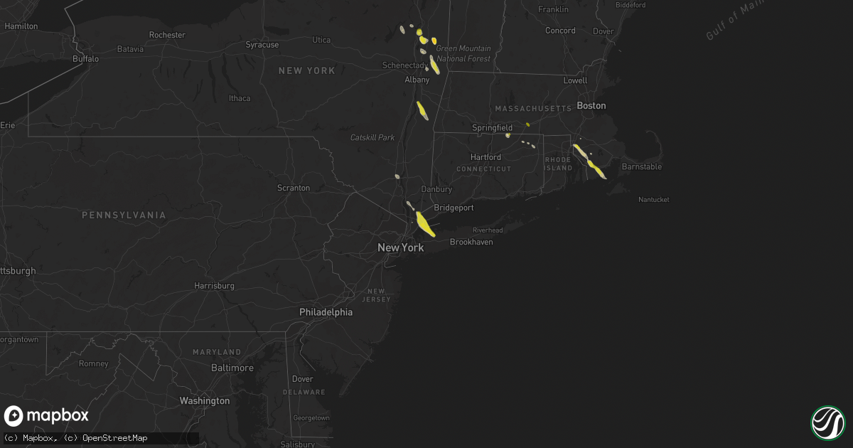
Hail Map on June 6, 2023
Get this storm
June 6 map
$229
one time, instant access
Download today. No call, no setup
Keep the $229
Bought the map and want the full workflow? Apply the entire $229 to a subscription within 7 days. None of it is wasted.
Every map, not just this one
This buys you this map. Subscription and you get every map we run, in the markets you choose from a few cities to whole states to nationwide. Plus real-time alerts the moment a storm fires.
Contact data
Name, contact info, occupancy, even credit band for addresses in the footprint. You go from where it hit to who to call.
Become the source they trust
Unlimited branding weather history reports on demand. You already have the documented answer ready for the property owner, and you are the one who showed up with it.
Property data and RoofTrace estimates
Pull up any address you have got, its value and the exact code rules for that jurisdiction, straight from One Click Code. Then RoofTrace estimates the squares, pitch, and roof value, priced the way you price.
States Impacted by Hail Map on June 6, 2023
Storm reports
Massachusetts
| Date | Description |
|---|---|
| 06/06/20233:39 PM CDT | Social media photo of hail ranging from dime to quarter size in rehoboth. Report time radar-estimated. |
| 06/06/20232:25 PM CDT | Reported by nws employee traveling on massachusetts pike. |
South Carolina
| Date | Description |
|---|---|
| 06/06/20236:34 PM CDT | Emergency manager reported two trees down near islandton. One tree was located in the 500 block of ashton road and another in the 1100 block of buckner road. Both trees |
| 06/06/20235:48 PM CDT | The charleston county 911 call center received a report of a tree down near the intersection of lincolnville and von ohsen rd. Time estimated via radar data. |
| 06/06/20234:26 PM CDT | 1.25 inch hail reported at coleman avenue in fountain inn. |
| 06/06/20234:21 PM CDT | Motorist reported on social media that they drove through quarter size hail on i-385 between simpsonville and fountain inn. |
| 06/06/20234:16 PM CDT | Two rounds of hail occurred with the second round containing up to quarter size hail with hail covering the ground. |
| 06/06/20234:11 PM CDT | Tree down in the hunters woods neighborhood. |
| 06/06/20234:11 PM CDT | Social media picture of a large tree uprooted along southeast main st. |
| 06/06/20234:06 PM CDT | Social media picture of two traffic lights blown down at the fairview rd exit from i-385. |
| 06/06/20234:06 PM CDT | Social media picture of restaurant sign blown out. |
| 06/06/20234:06 PM CDT | Tree down on a home on canebrake ln. |
| 06/06/20233:34 PM CDT | Broadcast media relayed a report... Via social media... Of a medium size tree down onto the westbound lanes of us hwy 1/601 |
| 06/06/20231:34 AM CDT | Emergency manager reported a tree down along community lane near gateway lane. The tree was blocking the roadway. Time estimated from radar. |
| 06/06/202312:42 AM CDT | 911 call center reported a tree down in the 1200 block of 1st bend road. The tree was blocking the roadway. Time estimated from radar. |
| 06/05/202310:30 PM CDT | Lee county sheriff reported to 911 dispatch 3 trees down on raccoon road near hwy 401. Time estimated by radar. |
| 06/05/20239:50 PM CDT | A tree fell on us hwy 521 and alice dr. Time estimated. |
| 06/05/20239:00 PM CDT | A tree fell on us hwy 378 and hwy 261... Just west of shaw afb. Time estimated. |
Idaho
| Date | Description |
|---|---|
| 06/06/20236:45 PM CDT | Itd rwis itd47 juniper interchange with sustained winds at 48 mph gusting to 70 mph reducing visibility to a quarter mile. |
| 06/05/20239:25 PM CDT | Mesonet station ts962 7 wnw mountain home afb. |
| 06/05/20239:10 PM CDT | Awos station kmuo mountain home afb. |
| 06/05/20239:00 PM CDT | Mesonet station gdvi 5.2 se grand view |
| 06/05/20237:10 PM CDT | Private weather station kidmalta8. |
Pennsylvania
| Date | Description |
|---|---|
| 06/06/20233:05 PM CDT | Tree fell on wires at haws ave. And w. Oak st. |
| 06/06/20233:05 PM CDT | A local report indicates 1.75 inch wind near King of Prussia |
| 06/06/20232:45 PM CDT | A local report indicates 63 MPH wind near Pottstown |
| 06/06/20232:45 PM CDT | Tree limbs and power lines down. |
| 06/06/20231:25 PM CDT | Multiple reports of trees and wires down in newberry... Conewango... And manchester townships. |
| 06/06/202312:30 PM CDT | Roof damage to a home in yeagertown. |
Mississippi
| Date | Description |
|---|---|
| 06/06/20233:27 PM CDT | Quarter size hail reported at walmart in olive branch. |
Texas
| Date | Description |
|---|---|
| 06/06/20236:59 PM CDT | Fallen tree on power lines. |
| 06/06/20236:55 PM CDT | A local report indicates 1.00 inch wind near 6 ENE Fort Bliss |
| 06/06/20236:53 PM CDT | Severe wind gust of 63 mph reported by a observation site on south franklin peak. |
| 06/06/20236:51 PM CDT | Tree in the street. |
| 06/06/20236:50 PM CDT | Tree down in the street... Size is unknown. |
| 06/06/20236:25 PM CDT | Severe wind gust of 63 mph reported from mesonet site in fabens... Tx. |
| 06/06/20236:10 PM CDT | Time and location estimated based on social media report. |
| 06/05/20237:09 PM CDT | Tree on power lines. |
| 06/05/20237:03 PM CDT | Tree down at the intersection of dyer st and hayes ave. |
Utah
| Date | Description |
|---|---|
| 06/06/20236:42 PM CDT | Mesonet station rsbu1 rosebud. |
| 06/06/20236:40 PM CDT | Mesonet station ut30 3.1 e collinston |
| 06/06/20235:49 PM CDT | Mesonet station ur308 2.5 nw lucin |
| 06/06/20235:23 PM CDT | Mesonet station ur305 27.0 e lucin |
| 06/06/20235:15 PM CDT | Hat island - 4242 ft |
| 06/06/20235:15 PM CDT | Hat island - 4242 ft. |
| 06/06/20235:10 PM CDT | Wendover port of entry - 4227 ft |
| 06/06/20235:10 PM CDT | Wendover port of entry - 4227 ft. |
| 06/06/20234:45 PM CDT | Bonneville salt flats - 4218 ft |
| 06/06/20234:45 PM CDT | Bonneville salt flats - 4218 ft. |
| 06/06/20234:41 PM CDT | A local report indicates 70 MPH wind near BARRO |
| 06/06/20234:41 PM CDT | A local report indicates 70 MPH wind near BARRO |
| 06/06/20234:40 PM CDT | I-80 at mp 29 - 4223 ft |
| 06/06/20234:40 PM CDT | I-80 at mp 29 - 4223 ft. |
| 06/06/20234:35 PM CDT | Interstate 80 - 4125 ft |
| 06/06/20234:35 PM CDT | Interstate 80 - 4125 ft. |
| 06/06/20234:10 PM CDT | West of wildcat mtn - 4259 ft |
| 06/06/20234:10 PM CDT | West of wildcat mtn - 4259 ft. |
| 06/06/20233:55 PM CDT | Salt flats - 4265 ft. |
| 06/06/20233:55 PM CDT | Salt flats - 4265 ft |
| 06/06/20233:35 PM CDT | Camel back mtn - 5077 ft. |
| 06/06/20233:35 PM CDT | Camel back mtn - 5077 ft |
| 06/06/20233:15 PM CDT | White sage - 4363 ft |
| 06/06/20233:15 PM CDT | White sage - 4363 ft. |
| 06/05/20237:30 PM CDT | Mesonet station pc358 hansel valley. |
Oklahoma
| Date | Description |
|---|---|
| 06/06/20236:30 PM CDT | Large tree branches and small trees down along riverside south of 81st. |
| 06/06/20236:30 PM CDT | Twitter photo of tree damage near 91st and delaware in south tulsa/jenks area...time estimated by radar. |
| 06/06/20236:30 PM CDT | Twitter photos of tree damage at the citiplex towers near 81st and lewis in tulsa...time estimated by radar. |
| 06/06/20235:17 PM CDT | Report from mping: quarter |
| 06/06/20235:11 PM CDT | Shared a twitter photo from a viewer of some tree damage near 101st and 193rd in ba...time estimated by radar. |
| 06/06/20234:08 PM CDT | A local report indicates 1.25 inch wind near 3 NNW Stillwater |
| 06/06/20234:06 PM CDT | A local report indicates 1.50 inch wind near 5 E Lake Mcmurtry |
| 06/06/20233:45 PM CDT | A local report indicates 1.00 inch wind near 4 NW Stillwater |
| 06/06/20233:28 PM CDT | A local report indicates 1.00 inch wind near 9 NNW Guthrie |
| 06/05/20237:34 PM CDT | Report from mping: quarter |
Iowa
| Date | Description |
|---|---|
| 06/05/20237:05 PM CDT | Report via twitter picture. Time taken from twitter comment on aforementioned twitter picture. |
Nevada
| Date | Description |
|---|---|
| 06/06/20235:26 PM CDT | Mesonet station crsn2 crane springs raws station elevation: 6414 ft. |
| 06/06/20235:19 PM CDT | Mesonet station up994 3.1 se west wendover |
| 06/06/20234:53 PM CDT | Mesonet station tornv 9.8 ne trinity junction |
New York
| Date | Description |
|---|---|
| 06/06/20236:23 PM CDT | Time estimated by radar |
| 06/06/20234:38 PM CDT | A local report indicates 1.00 inch wind near Hagaman |
| 06/06/20232:21 PM CDT | A local report indicates 1.00 inch wind near Grafton |
| 06/06/20232:19 PM CDT | Time estimated from radar |
| 06/06/20232:10 PM CDT | A local report indicates 1.00 inch wind near Pittstown |
| 06/06/20232:08 PM CDT | A local report indicates 1.00 inch wind near 1 NW Harrison |
| 06/06/20232:08 PM CDT | A local report indicates 1.00 inch wind near 1 S Harrison |
| 06/06/20231:53 PM CDT | Estimated by pictures. |
| 06/06/20231:38 PM CDT | Estimated by picture. Time estimated by radar. |
| 06/06/20231:35 PM CDT | Quarter size hail... Some slightly larger. Comfirmed by picture. Time estimated by radar. |
| 06/06/20231:19 PM CDT | Corrected time. |
| 06/06/202312:50 PM CDT | A local report indicates 1.00 inch wind near Ballard Corners |
| 06/06/202312:47 PM CDT | A local report indicates 1.00 inch wind near Ballard Corners |
| 06/06/202312:46 PM CDT | A local report indicates 1.00 inch wind near Schuylerville |
Georgia
| Date | Description |
|---|---|
| 06/06/20235:30 PM CDT | Phone lines down at e hightower and thurmand baccus rd. |
| 06/06/20235:29 PM CDT | Tree down blocking roadway at old monroe madison hwy and queens cemetery rd. |
| 06/06/20235:29 PM CDT | Multiple trees down down at lipscomb rd near ivery rd and mt paran church rd near social circle fairplay rd. |
| 06/06/20235:27 PM CDT | Tree downed in roadway at miller bottom rd and s sharon church rd. |
| 06/06/20235:10 PM CDT | Burke county emergency manager reported downed powerlines causing 2 small grass fires at 632 claxton road near girard... Ga. Time estimated from radar. |
| 06/06/20234:59 PM CDT | Multiple trees snapped or uprooted in waynesboro city park. Photos sent to the nws by emergency manager. Time estimated from radar. Nearby on spring valley road near th |
| 06/06/20234:50 PM CDT | Burke county emergency manager reported downed powerlines causing a small grass fire at 8033 river road in eastern burke county... Ga. Time estimated from radar. |
| 06/06/20234:35 PM CDT | Burke county emergency manager reported trees down on highway 80 near susie bailey road and massey-doss road between waynesboro and gough... Ga. Time estimated from rad |
| 06/06/20234:33 PM CDT | A local report indicates 1.00 inch wind near Barnett |
| 06/06/20234:27 PM CDT | Burke county emergency manager reported a large tree down on the 200 block of spread oak road. Time estimated from radar. |
| 06/06/20234:23 PM CDT | Burke county emergency manager reported a tree down on powerlines on west quaker road in the keysville... Ga area. Time estimated from radar. |
| 06/06/20234:20 PM CDT | Tree down at bentley and terrell mill rd. |
| 06/06/20234:20 PM CDT | A local report indicates 1.00 inch wind near 2 N Truist Park |
| 06/06/20234:10 PM CDT | Burke county emergency manager reported a tree down on powerlines in the 100 block of hopson mill road near blythe... Ga. Time estimated from radar. |
| 06/06/20234:04 PM CDT | Quarter size hail reported by personnel at graphic packaging international plant south of bush field. |
| 06/06/20234:00 PM CDT | Couple trees down at i20 at mm 154. |
| 06/06/20233:54 PM CDT | Richmond co dispatch reported a tree and power line down at peach orchard rd and brown rd. Time estimated. |
| 06/05/20237:30 PM CDT | Trees down at wrightsboro rd and gateway blvd. Time estimated. |
| 06/05/20237:25 PM CDT | Multiple trees down within the town limits of harlem... Including one down on a house and car on w. Forrest st. Time estimated. |
Connecticut
| Date | Description |
|---|---|
| 06/06/20233:26 PM CDT | At the momson ma and stafford ct border. Relayed by amateur radio. |
Minnesota
| Date | Description |
|---|---|
| 06/06/20234:30 PM CDT | Estimated 8 inch diameter pine snapped a few feet above the ground. |
Montana
| Date | Description |
|---|---|
| 06/06/20233:50 PM CDT | Also reported heavy rain... 35 mph wind gusts estimated. |
| 06/05/20239:04 PM CDT | A local report indicates 1.25 inch wind near 1 WSW Hardin |
| 06/05/20239:00 PM CDT | Heavy rain in addition to the hail. |
| 06/05/20239:00 PM CDT | A local report indicates 1.00 inch wind near 1 ENE Hardin |
Colorado
| Date | Description |
|---|---|
| 06/06/20236:47 PM CDT | Spotter saw a land spout. |
| 06/06/20236:39 PM CDT | State patrol visually confirmed land spout. |
| 06/06/20236:12 PM CDT | A local report indicates 1.00 inch wind near 2 NNE Foxfield |
| 06/06/20236:08 PM CDT | Ab117. |
| 06/06/20235:43 PM CDT | La786. |
New Mexico
| Date | Description |
|---|---|
| 06/06/20236:36 PM CDT | Observed by mineral hill fire department. |
| 06/06/20235:40 PM CDT | New mexico forest and watershed institute. |
| 06/06/20235:34 PM CDT | A local report indicates 1.50 inch wind near 2 W Manuelitas |
| 06/06/20235:31 PM CDT | A local report indicates 1.00 inch wind near 2 SE Tierra Monte |
| 06/06/20235:30 PM CDT | A local report indicates 1.50 inch wind near Sapello |
| 06/06/20233:01 PM CDT | Very heavy rain and quarter sized hail falling at the time of report. |
California
| Date | Description |
|---|---|
| 06/06/20233:27 PM CDT | Mesonet station xmlc1 mill canyon. |
Cities Impacted by Hail Map on June 6, 2023
- Saratoga Springs, NY
- Gansevoort, NY
- Fort Lauderdale, FL
- North Miami Beach, FL
- Miami, FL
- Dania, FL
- Hollywood, FL
- Hallandale, FL
- Miami Beach, FL
- Stillwater, NY
- Schuylerville, NY
- Purchase, NY
- Port Chester, NY
- Greenwich, CT
- Rye, NY
- Valley Falls, NY
- Johnsonville, NY
- Troy, NY
- Cropseyville, NY
- West Harrison, NY
- White Plains, NY
- Harrison, NY
- Locust Valley, NY
- Bayville, NY
- Oyster Bay, NY
- Mill Neck, NY
- Cold Spring Harbor, NY
- Syosset, NY
- East Norwich, NY
- Woodbury, NY
- Huntington, NY
- Sturbridge, MA
- Charlton, MA
- Huntington Station, NY
- Mulhall, OK
- Guadalupita, NM
- Ocate, NM
- Guthrie, OK
- Atlanta, KS
- Ozark, AR
- Olive Branch, MS
- Stafford Springs, CT
- Monson, MA
- Stillwater, OK
- Greenfield Center, NY
- Malta, MT
- Dodson, MT
- Loring, MT
- Whitewater, MT
- Hephzibah, GA
- Augusta, GA
- Snow Lake, AR
- Parker, CO
- Sapello, NM
- Las Vegas, NM
- Aurora, CO
- Englewood, CO
- Denver, CO
- Kinderhook, NY
- Stuyvesant, NY
- Stuyvesant Falls, NY
- Hudson, NY
- Ghent, NY
- Idaho Falls, ID
- Commerce City, CO
- Brighton, CO
- Philmont, NY
- Hillsdale, NY
- San Elizario, TX
- El Paso, TX
- Guffey, CO
- Hogeland, MT
- Ballston Spa, NY
- Douglas, OK
- Gallup, NM
- Ganado, AZ
- Ponca City, OK
- Croghan, NY
- Kingfisher, OK
- Dover, OK
- Coweta, OK
- Broken Arrow, OK
- Northville, NY
- Hadley, NY
- Corinth, NY
- Cedar Vale, KS
- Edwards, MS
- Blythe, GA
- Reed Point, MT
- Big Timber, MT
- Capitan, NM
- Rociada, NM
- Victory Mills, NY
- La Junta, CO
- Greenwich, NY
- Bartlesville, OK
- Mahnomen, MN
- Melrose, NY
- Petersburg, NY
- Labelle, FL
- Armonk, NY
- Lamont, OK
- Atlanta, GA
- Marietta, GA
- Smyrna, GA
- Vernon, FL
- Chipley, FL
- Uniontown, AR
- Muldrow, OK
- Van Buren, AR
- Natural Dam, AR
- Cedarville, AR
- Chambers, AZ
- Pawhuska, OK
- Winnie, TX
- Clarksville, IA
- Shell Rock, IA
- Perry, OK
- Morrison, OK
- Glencoe, OK
- North Dartmouth, MA
- South Dartmouth, MA
- New Bedford, MA
- Gloversville, NY
- Johnstown, NY
- Fountain Inn, SC
- Simpsonville, SC
- Shidler, OK
- Watonga, OK
- Ossining, NY
- Bixby, OK
- Seekonk, MA
- Swansea, MA
- Rehoboth, MA
- Attleboro, MA
- Dighton, MA
- Somerset, MA
- Schertz, TX
- Fall River, MA
- Pawtucket, RI
- Princeton, TX
- Farmersville, TX
- Norwood, GA
- Crawfordville, GA
- Tonkawa, OK
- Copan, OK
- Wann, OK
- Gary, MN
- Cushing, OK
- Wayne, PA
- Norristown, PA
- King Of Prussia, PA
- Claremore, OK
- San Antonio, TX
- Converse, TX
- Briarcliff Manor, NY
- Chappaqua, NY
- Valliant, OK
- Franklin, LA
- Jefferson, CO
- Schenectady, NY
- La Veta, CO
- Waynesboro, GA
- Mechanicville, NY
- Schaghticoke, NY
- Pleasanton, TX
- Niotaze, KS
- Valhalla, NY
- Thornwood, NY
- Powell, WY
- Ripley, OK
- Pomfret, CT
- Pomfret Center, CT
- Pawnee, OK
- Okarche, OK
- Westport, MA
- Bluff City, KS
- Ashland, MS
- Newburgh, NY
- Elaine, AR
- Calumet, OK
- Paris, TX
- Brookston, TX
- Aragon, NM
- Datil, NM
- Greenville, SC
- Mauldin, SC
- Hennessey, OK
- Mamaroneck, NY
- Pleasantville, NY
- Blenheim, SC
- Assonet, MA
- Green River, UT
- New Braunfels, TX
- Woodstock, CT
- Potts Camp, MS
- Hernando, MS
- Tunica, MS
- Fence Lake, NM
- Poplar Grove, AR
- Cotopaxi, CO
- Frisco City, AL
- Lilburn, GA
- Snellville, GA
- Brewton, AL
- Inola, OK
- Bozeman, MT
- Scarsdale, NY
- Fairmont, OK
- Lake Luzerne, NY
- Greer, SC
- Blossom, TX
- Southaven, MS
- Prairie Grove, AR
- Crescent, OK
- Phoenixville, PA
- Collegeville, PA
- Yale, OK
- Weed, NM
- Eastford, CT
- Mansfield, TX
- Mooreland, OK
- Jbsa Randolph, TX
- Cibolo, TX
- Universal City, TX
- Follett, TX
- Beaumont, TX
- Marianna, AR
- Lexa, AR
- Iuka, MS
- Wallkill, NY
- Amsterdam, NY
- Mount Hope, AL
- Russellville, AL
- Skiatook, OK
- Lake Cormorant, MS
- Tulsa, OK
- Gage, OK
- El Reno, OK
- Croton On Hudson, NY
- Cortlandt Manor, NY
- Duncanville, TX
- Gray Court, SC
- Woodruff, SC
- Devers, TX
- Monroe, GA
- Loganville, GA
- Fort Bliss, TX
- Hardin, MT
- Crow Agency, MT
- Hollywood, SC
- Rapelje, MT
- Deming, NM
- Beggs, OK
- Fort Lupton, CO
- Fort Hancock, TX
- Waco, TX
- West, TX
- Haskell, OK
- Clayton, OK
- Snow, OK
- Chanute, KS
- Hayfork, CA
- Morris, OK
- Porter Corners, NY
- Campbell, MN
- Foxhome, MN
- Fergus Falls, MN
- Magdalena, NM
- Broadview, MT
- Molt, MT
- Sapulpa, OK
- Jenks, OK
- Las Cruces, NM
- North Charleston, SC
- Kiefer, OK
- Mounds, OK
- Appling, GA
- Harlem, GA
- Grovetown, GA
- Varnville, SC
- Tohatchi, NM
- Boise, ID
- Garden City, ID
- Dearing, GA
- Thomson, GA
- Pecos, NM
- Laramie, WY
- Braman, OK
- Blackwell, OK
- Eagle, ID
- Telephone, TX
- Bokchito, OK
- Ivanhoe, TX
- Soda Springs, CA
- Emigrant Gap, CA
- Tremonton, UT
- Honeyville, UT
- Craryville, NY
- Castle Rock, CO
- Tornillo, TX
- South Haven, KS
- Ribera, NM
- Montezuma, NM
- Crystal Springs, MS
- Hampton, SC
- Huntley, MT
- Ballantine, MT
- Columbus, MT
- Adams Run, SC
- San Jose, NM
- Carrizozo, NM
- Joliet, MT
- Roberts, MT
- Dallas, GA
- Bearcreek, MT
- Summerville, SC
- Charleston, SC
- Johns Island, SC
- Ravenel, SC
- Walsenburg, CO
- Ogden, UT
- Glenpool, OK
- Madison, GA
- Bear River City, UT
- Brigham City, UT
- Kim, CO
- Garland, UT
- Corona, NM
- Crownpoint, NM
- Bluejacket, OK
- Alva, OK
- Glade Park, CO
- Early Branch, SC
- El Dorado, AR
- Estancia, NM
- Goldthwaite, TX
- Loris, SC
- Longs, SC
- Norton, MA
- Zuni, NM
- Olney Springs, CO
- Ordway, CO
- Sandia Park, NM
- Hudson, CO
- Warrenton, GA
- Coldwater, KS
- Castleberry, AL
- Grants, NM
- Model, CO
- Serafina, NM
- Latta, SC
- Truth Or Consequences, NM
- Burbank, OK
- Fairfax, OK
- Jemez Pueblo, NM
- Park City, MT
- Fabens, TX
- Cloudcroft, NM
- Waynoka, OK
- Wellington, KS
- Belden, CA
- Twain, CA
- Ochelata, OK
- Altamont, KS
- Edgewood, NM
- Elk City, KS
- East Moriches, NY
- Center Moriches, NY
- Manorville, NY
- Columbia, SC
- Eastover, SC
- Toxey, AL
- Gilbertown, AL
- Newkirk, OK
- Sierra Blanca, TX
- Social Circle, GA
- Greeley, CO
- Mannford, OK
- Rutledge, GA
- Bennington, OK
- Atmore, AL
- Rattan, OK
- Conyers, GA
- Moncks Corner, SC
- Pinopolis, SC
- Magnolia, MS
- Jemez Springs, NM
- Osyka, MS
- Florence, SC
- Good Hope, GA
- San Rafael, NM
- Timmonsville, SC
- Rembert, SC
- Dalzell, SC
- Sumter, SC
- Cross, SC
- Mayesville, SC
- Wedgefield, SC
- Shaw Afb, SC
- Woodstock Valley, CT
- Union Point, GA
- Reevesville, SC
- Branchville, SC
- Saint George, SC
- Bishopville, SC
- Glen Cove, NY
- Brunson, SC
- Camak, GA
- Estill, SC
- Girard, GA
- Lugoff, SC
- Somers, CT
- Camden, SC
- Pompeys Pillar, MT
- Berkley, MA
- Waucoma, IA