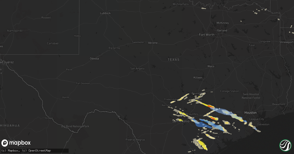
Hail Map in Texas on June 6, 2019
Get this storm
June 6 map
$229
one time, instant access
Download today. No call, no setup
Keep the $229
Bought the map and want the full workflow? Apply the entire $229 to a subscription within 7 days. None of it is wasted.
Every map, not just this one
This buys you this map. Subscription and you get every map we run, in the markets you choose from a few cities to whole states to nationwide. Plus real-time alerts the moment a storm fires.
Contact data
Name, contact info, occupancy, even credit band for addresses in the footprint. You go from where it hit to who to call.
Become the source they trust
Unlimited branding weather history reports on demand. You already have the documented answer ready for the property owner, and you are the one who showed up with it.
Property data and RoofTrace estimates
Pull up any address you have got, its value and the exact code rules for that jurisdiction, straight from One Click Code. Then RoofTrace estimates the squares, pitch, and roof value, priced the way you price.
Storm reports in Texas
Texas
| Date | Description |
|---|---|
| 06/06/20196:45 PM CDT | A local report indicates 2.00 inch wind near BLANCONIA |
| 06/06/20196:41 PM CDT | Trees blown down on sh95 between shiner and yoakum. Time of event estimated with radar. |
| 06/06/20196:41 PM CDT | Power poles down and a trailer flipped just east of intersection of highways 44 and 359 on the east...northeast side of alice |
| 06/06/20196:35 PM CDT | Fort bend co. Sheriff's office reported power lines down on fm2977. |
| 06/06/20196:30 PM CDT | Fort bend co. Sheriff's office reported trees down on power lines near intersection of n karaugh dr and winner foster rd. |
| 06/06/20196:22 PM CDT | Report from the berclair country store |
| 06/06/20196:13 PM CDT | Fort bend co. Sherrif's office reports roof damage to home. |
| 06/06/20196:10 PM CDT | 4 inch diameter tree limbs broken. |
| 06/06/20196:04 PM CDT | Houses damaged... East bernard at hwy 60 |
| 06/06/20196:03 PM CDT | Trees and powerlines blown down in nixon. Time of event estimated with radar. |
| 06/06/20196:02 PM CDT | Quarter sized hail on n st. Marys street just south of ih35. |
| 06/06/20195:59 PM CDT | Quarter sized hail in downtown san antonio. |
| 06/06/20195:57 PM CDT | . |
| 06/06/20195:57 PM CDT | Quarter sized hail measured at san pedro and basse. |
| 06/06/20195:54 PM CDT | Billboard sign blown down at i-10 and n laredo st. |
| 06/06/20195:49 PM CDT | Tree blown down on king william street. Time of event estimated with radar. |
| 06/06/20195:48 PM CDT | Media relayed report of quarter sized hail in los angeles heights. Time of event estimated with radar. |
| 06/06/20195:42 PM CDT | Trees and power lines blown down in cost. Time of event estimated with radar. |
| 06/06/20195:36 PM CDT | A local report indicates 1.75 inch wind near 7 SE MOULTON |
| 06/06/20195:27 PM CDT | Local emergency management reports overturned semi and travel trailer on interstate 10 westbound at alleyton... Multiple trees down... Moblie home blown over. |
| 06/06/20195:20 PM CDT | Colorado co. Sheriff's office reports trees down at wanlut st & travis st in columbus. |
| 06/06/20195:14 PM CDT | 3 inch tree limbs blown down and power poles damaged. |
| 06/06/20195:00 PM CDT | Large oak trees blown down. |
| 06/06/20194:55 PM CDT | The county emergency manager reports multiple trees down in the city of la grange. |
| 06/06/20194:35 PM CDT | Public reports quarter to golf ball size hail along highway 71 in west point. |
| 06/06/20194:20 PM CDT | A gas station in smithville reported quarter to golf ball size hail fell at that location. |
| 06/06/20194:03 PM CDT | There was sign and tree damage at a store off county road 304. Nickel size hail also reported at this location. |
| 06/06/20194:01 PM CDT | A local report indicates 1.00 inch wind near 1 E BULVERDE |
| 06/06/20193:55 PM CDT | Tree that was blown down was blocking one lane of us281. |
| 06/06/20193:50 PM CDT | Multiple trees and power poles blown down in bulverde. Time estimated with radar. |
| 06/06/20193:31 PM CDT | Parmer at dessau. |
| 06/06/20193:04 AM CDT | At 803 PM CDT, a severe thunderstorm was located near Riviera Beach, or 12 miles east of Sarita, moving southeast at 35 mph. This is a very dangerous storm. HAZARD...80 mph wind gusts and three inch hail. SOURCE...Radar indicated. IMPACT...Flying debris will be dangerous to those caught without shelter. Mobile homes will be heavily damaged. Expect considerable damage to roofs, windows, and vehicles. Extensive tree damage and power outages are likely. Locations impacted include... Kenedy County Wind Farms. |
| 06/06/20192:52 AM CDT | At 751 PM CDT, a severe thunderstorm was located 9 miles northeast of Riviera Beach, or 16 miles southeast of Kingsville, moving southeast at 35 mph. This is a very dangerous storm. HAZARD...80 mph wind gusts and three inch hail. SOURCE...Radar indicated. IMPACT...Flying debris will be dangerous to those caught without shelter. Mobile homes will be heavily damaged. Expect considerable damage to roofs, windows, and vehicles. Extensive tree damage and power outages are likely. Locations impacted include... Riviera Beach, Ricardo and Loyola Beach. |
| 06/06/20192:50 AM CDT | At 750 AM CDT, a severe thunderstorm was located near Blanconia, or near Refugio, moving east at 30 mph. HAZARD...Quarter size hail. SOURCE...Radar indicated. IMPACT...Damage to vehicles is expected. Locations impacted include... Refugio, Woodsboro, Quintana and Blanconia. |
| 06/06/20192:45 AM CDT | At 745 PM CDT, a severe thunderstorm was located near Beeville, moving southeast at 35 mph. HAZARD...60 mph wind gusts and half dollar size hail. SOURCE...Radar indicated. IMPACT...Hail damage to vehicles is expected. Expect wind damage to roofs, siding, and trees. Locations impacted include... Beeville, Skidmore, Papalote and Blanconia. |
| 06/06/20192:13 AM CDT | At 712 PM CDT, a severe thunderstorm was located near Driscoll, moving east at 25 mph. HAZARD...60 mph wind gusts and quarter size hail. SOURCE...Radar indicated. IMPACT...Hail damage to vehicles is expected. Expect wind damage to roofs, siding, and trees. Locations impacted include... Corpus Christi, Kingsville, Robstown, Driscoll, Bishop, Riviera Beach, Ricardo, Banquete, Malaquite Beach, Kingsville Naval Air Station, Kings Crossing Golf Course, Petronila, Loyola Beach and Chapman Ranch. |
| 06/06/20192:06 AM CDT | At 705 PM CDT, a severe thunderstorm was located over Tuleta, or 12 miles northwest of Beeville, moving southeast at 20 mph. Another severe thunderstorms was located 5 miles southwest of Charco, moving southeast at 20 mph. HAZARD...60 mph wind gusts and half dollar size hail. SOURCE...Radar indicated. IMPACT...Hail damage to vehicles is expected. Expect wind damage to roofs, siding, and trees. Locations impacted include... Beeville, Mineral, Berclair, Tulsita, Normanna, Pettus and Tuleta. |
| 06/06/20191:57 AM CDT | At 656 PM CDT, a severe thunderstorm was located 5 miles west of Refugio, moving southeast at 35 mph. This is a very dangerous storm. HAZARD...Baseball size hail and 70 mph wind gusts. SOURCE...Radar indicated. IMPACT...People and animals outdoors will be severely injured. Expect shattered windows, extensive damage to roofs, siding, and vehicles. Locations impacted include... Rockport, Refugio, Woodsboro, Lamar, Bayside, Quintana, Palm Harbor, Key Allegro, Copano Village, Bonnie View, Holiday Beach, Blanconia and Fulton. |
| 06/06/20191:49 AM CDT | At 649 PM CDT, a severe thunderstorm was located 7 miles south of Yoakum, moving southeast at 30 mph. HAZARD...60 mph wind gusts and penny size hail. SOURCE...Radar indicated. IMPACT...Expect damage to roofs, siding, and trees. Locations impacted include... Terryville. |
| 06/06/20191:46 AM CDT | At 643 PM CDT, a cluster of severe thunderstorms were located from Nada down towards Cordele, moving east at 35 mph. HAZARD...60 mph wind gusts and quarter size hail. SOURCE...Radar indicated. IMPACT...Hail damage to vehicles is expected. Expect wind damage to roofs, siding, and trees. Locations impacted include... El Campo, Wharton, Ganado, Pierce, Markham, Boling-Iago, Blessing, Cordele, Egypt, Louise, Midfield and Danevang. |
| 06/06/20191:44 AM CDT | At 643 PM CDT, a severe thunderstorm was located 8 miles west of Driscoll, moving east at 35 mph. HAZARD...60 mph wind gusts and half dollar size hail. SOURCE...Radar indicated. IMPACT...Hail damage to vehicles is expected. Expect wind damage to roofs, siding, and trees. Locations impacted include... Kingsville, Alice, Robstown, Driscoll, Bishop, Ben Bolt, Alice Acres, Agua Dulce, Petronila and Lake Alice. |
| 06/06/20191:28 AM CDT | At 626 PM CDT, a severe thunderstorm was located over southeastern Rosenberg, moving east at 30 mph. This storm has had a history of damaging winds. HAZARD...60 mph wind gusts and quarter size hail. SOURCE...Radar indicated. IMPACT...Hail damage to vehicles is expected. Expect wind damage to roofs, siding, and trees. Locations impacted include... Pearland, Sugar Land, Missouri City, Rosenberg, Alvin, Richmond, Manvel, Pecan Grove, First Colony, Fresno, Needville, Danbury, Arcola, Iowa Colony, Pleak, Fairchilds, Beasley, Bonney, Thompsons and New Territory. |
| 06/06/20191:26 AM CDT | At 625 PM CDT, a severe thunderstorm was located near Alfred-South La Paloma, or 13 miles northeast of Alice, moving east at 35 mph. HAZARD...70 mph wind gusts and quarter size hail. SOURCE...Radar indicated. IMPACT...Hail damage to vehicles is expected. Expect considerable tree damage. Wind damage is also likely to mobile homes, roofs, and outbuildings. Locations impacted include... Driscoll, Orange Grove, San Patricio, Alfred-South La Paloma, Alfred, Bluntzer, Banquete, Westdale and Agua Dulce. |
| 06/06/20191:22 AM CDT | At 622 PM CDT, a severe thunderstorm was located near Yoakum, moving southeast at 20 mph. HAZARD...60 mph wind gusts and half dollar size hail. SOURCE...Radar indicated. IMPACT...Hail damage to vehicles is expected. Expect wind damage to roofs, siding, and trees. Locations impacted include... Yoakum, Hallettsville, Shiner, Speaks, Ezzell, Worthing, Koerth, Terryville, Mount Olive, Mont, Sweet Home and Hope. |
| 06/06/20191:18 AM CDT | At 617 PM CDT, a severe thunderstorm was located near Mission Valley, or 13 miles west of Victoria, moving southeast at 30 mph. HAZARD...60 mph wind gusts and half dollar size hail. SOURCE...Radar indicated. IMPACT...Hail damage to vehicles is expected. Expect wind damage to roofs, siding, and trees. Locations impacted include... Victoria, Guadalupe, Fannin, Schroeder, Dacosta, Ander, Mission Valley, Victoria Detar Hospital North, Weser, Victoria Riverside Park, Coleto Creek Park, Victoria College, Saxet Lakes, Oak Village, Downtown Victoria and Bloomington. |
| 06/06/20191:11 AM CDT | At 610 PM CDT, a severe thunderstorm was located 7 miles east of Berclair, or 10 miles southwest of Goliad, moving southeast at 30 mph. HAZARD...Two inch hail and 70 mph wind gusts. SOURCE...Radar indicated. IMPACT...People and animals outdoors will be injured. Expect hail damage to roofs, siding, windows, and vehicles. Expect considerable tree damage. Wind damage is also likely to mobile homes, roofs, and outbuildings. Locations impacted include... Refugio, Woodsboro, Berclair and Blanconia. |
| 06/06/20191:07 AM CDT | At 605 PM CDT, a cluster of severe thunderstorms from the Sheridan down towards Morales, moving east 35 mph. HAZARD...60 mph wind gusts and quarter size hail. SOURCE...Radar indicated. IMPACT...Hail damage to vehicles is expected. Expect wind damage to roofs, siding, and trees. Locations impacted include... El Campo, Wharton, Pierce, Cordele, Egypt, Louise, Hungerford, Sheridan, Altair, Nada, Morales, Garwood, Rock Island and Danevang. |
| 06/06/20191:03 AM CDT | At 602 PM CDT, a severe thunderstorm was located over Midway, or 17 miles west of Mathis, moving east at 20 mph. HAZARD...60 mph wind gusts and quarter size hail. SOURCE...Radar indicated. IMPACT...Hail damage to vehicles is expected. Expect wind damage to roofs, siding, and trees. Locations impacted include... Orange Grove, Lake City, Midway, Lagarto, Alfred-South La Paloma, Westdale, Sandia, Annarose, Rancho De La Parita, Alfred, Clegg, Lakeside, Lake Corpus Christi and Pernitas Point. |
| 06/06/201912:47 AM CDT | At 546 PM CDT, a severe thunderstorm was located over San Antonio, moving southeast at 35 mph. HAZARD...60 mph wind gusts and quarter size hail. SOURCE...Radar indicated. IMPACT...Hail damage to vehicles is expected. Expect wind damage to roofs, siding, and trees. Locations impacted include... San Antonio, Schertz, San Antonio Int Airport, Stinson Municipal Airport, Leon Valley, Kirby, Alamo Heights, Windcrest, Terrell Hills, Olmos Park, St. Hedwig, Elmendorf, La Vernia, China Grove, Calaveras Lake, Lackland AFB, Converse, Castle Hills, Sandy Oaks and Balcones Heights. |
| 06/06/201912:45 AM CDT | At 542 PM CDT, a severe thunderstorm was located 8 miles northeast of Eagle Lake, moving east at 45 mph. Law enforcement has reported trees down near Columbus. HAZARD...60 mph wind gusts and quarter size hail. This storm has had a history of producing damaging winds. SOURCE...Radar indicated. IMPACT...Hail damage to vehicles is expected. Expect wind damage to roofs, siding, and trees. Locations impacted include... Western Rosenberg, Katy, Sealy, Brookshire, Bellville, Eagle Lake, East Bernard, Wallis, Fulshear, Simonton, San Felipe, Beasley, Pattison, Kendleton, Orchard, Weston Lakes, Cinco Ranch, Hungerford, Cat Spring and Altair. |
| 06/06/201912:42 AM CDT | At 542 PM CDT, a severe thunderstorm was located 10 miles south of Seguin, moving southeast at 30 mph. HAZARD...60 mph wind gusts and penny size hail. SOURCE...Radar indicated. IMPACT...Expect damage to roofs, siding, and trees. Locations impacted include... Seguin, Nixon, Smiley, Pandora, Leesville, Bebe and Wrightsboro. |
| 06/06/201912:42 AM CDT | At 541 PM CDT, a severe thunderstorm was located near Pettus, or 13 miles southeast of Kenedy, moving east at 25 mph. HAZARD...60 mph wind gusts and quarter size hail. SOURCE...Radar indicated. IMPACT...Hail damage to vehicles is expected. Expect wind damage to roofs, siding, and trees. Locations impacted include... Goliad, Pettus, Berclair, Charco and Tuleta. |
| 06/06/201912:32 AM CDT | At 532 AM CDT, a severe thunderstorm was located 8 miles southwest of Eagle Lake, moving east at 35 mph. HAZARD...60 mph wind gusts and quarter size hail. SOURCE...Radar indicated. IMPACT...Hail damage to vehicles is expected. Expect wind damage to roofs, siding, and trees. Locations impacted include... Wharton, Eagle Lake, East Bernard, Altair, Nada, Egypt, Garwood and Hungerford. |
| 06/06/201912:23 AM CDT | At 522 PM CDT, a severe thunderstorm was located over Moulton, moving east at 35 mph. HAZARD...60 mph wind gusts and quarter size hail. SOURCE...Radar indicated. IMPACT...Hail damage to vehicles is expected. Expect wind damage to roofs, siding, and trees. Locations impacted include... Hallettsville, Moulton, Sublime, Komensky, Henkhaus, Moravia, Witting, Vienna and U.S. Highway 77. |
| 06/06/201912:11 AM CDT | At 511 PM CDT, a severe thunderstorm was located over Fayetteville, or 11 miles east of La Grange, moving east at 10 mph. HAZARD...60 mph wind gusts. SOURCE...Radar indicated. IMPACT...Expect damage to roofs, siding, and trees. Locations impacted include... Fayetteville and Ellinger. |
| 06/06/201912:08 AM CDT | At 507 PM CDT, a severe thunderstorm was located over Fayetteville, or 11 miles east of La Grange, moving east at 25 mph. HAZARD...60 mph wind gusts and quarter size hail. This storm has a history of producing heavy rain, large hail, and damaging winds. SOURCE...Radar indicated. IMPACT...Hail damage to vehicles is expected. Expect wind damage to roofs, siding, and trees. Locations impacted include... Sealy, Bellville, Columbus, Eagle Lake, Shelby, Weimar, San Felipe, Industry, Frelsburg, New Ulm and Cat Spring. |
| 06/06/201912:05 AM CDT | At 505 PM CDT, a severe thunderstorm was located near Flatonia, moving east at 35 mph. HAZARD...60 mph wind gusts and quarter size hail. SOURCE...Radar indicated. IMPACT...Hail damage to vehicles is expected. Expect wind damage to roofs, siding, and trees. Locations impacted include... Flatonia, Muldoon, O'Quinn, Floy and Colony. |
| 06/05/201911:59 PM CDT | At 459 PM CDT, a severe thunderstorm was located near La Grange, moving east at 15 mph. HAZARD...60 mph wind gusts. SOURCE...Radar indicated. IMPACT...Expect damage to roofs, siding, and trees. Locations impacted include... Swiss Alp, Ellinger, Mullins Prairie, Ammannsville and Holman. |
| 06/05/201911:49 PM CDT | At 449 PM CDT, a severe thunderstorm was located near Tanglewood Forest, moving east at 25 mph. HAZARD...60 mph wind gusts and quarter size hail. SOURCE...Radar indicated. IMPACT...Hail damage to vehicles is expected. Expect wind damage to roofs, siding, and trees. Locations impacted include... Austin, Elgin, Bastrop, Tanglewood Forest, Austin Bergstrom Int Airport, Manor, West Lake Hills, Rollingwood, Barton Creek, Shady Hollow, Wyldwood, Onion Creek, Camp Swift, Hornsby Bend, Manchaca, Sunset Valley, San Leanna, Webberville, Phelan and Cedar Hills. |
| 06/05/201911:11 PM CDT | At 411 PM CDT, a severe thunderstorm was located near Smithville, moving east at 15 mph. HAZARD...60 mph wind gusts and quarter size hail. SOURCE...Radar indicated. IMPACT...Hail damage to vehicles is expected. Expect wind damage to roofs, siding, and trees. Locations impacted include... Bastrop, La Grange, Smithville, Fayetteville, Round Top, Upton, Carmine, Bastrop State Park, Hills Prairie, Rutersville, Northrup, Warrenton, Ledbetter, Waldeck, Plum, Buescher State Park, Mullins Prairie, Nechanitz, Serbin and Togo. |
| 06/05/201910:51 PM CDT | At 351 PM CDT, a severe thunderstorm was located over Bulverde, or 15 miles northwest of Selma, moving east at 30 mph. HAZARD...60 mph wind gusts and quarter size hail. SOURCE...Radar indicated. IMPACT...Hail damage to vehicles is expected. Expect wind damage to roofs, siding, and trees. Locations impacted include... San Antonio, New Braunfels, Schertz, Cibolo, Universal City, Live Oak, Selma, Randolph AFB, Canyon Lake, Bulverde, Garden Ridge, Hollywood Park, Smithson Valley, Timberwood Park, Spring Branch, Converse, Anhalt, Startzville, Bracken and Sattler. |
| 06/05/201910:38 PM CDT | At 337 PM CDT, a severe thunderstorm was located near Wyldwood, or 7 miles southeast of Austin Bergstrom Int Airport, moving east at 15 mph. HAZARD...60 mph wind gusts and quarter size hail. SOURCE...Radar indicated. IMPACT...Hail damage to vehicles is expected. Expect wind damage to roofs, siding, and trees. Locations impacted include... Austin, Bastrop, Smithville, Circle D-KC Estates, Cedar Creek, Camp Swift, Wyldwood, Hornsby Bend, Upton, Webberville, Phelan, Bastrop State Park, Hills Prairie, Alum Creek, Buescher State Park, McDade and Del Valle. |
| 06/05/201910:25 PM CDT | At 325 PM CDT, a severe thunderstorm was located near Manor, or near Pflugerville, moving east at 30 mph. HAZARD...70 mph wind gusts and quarter size hail. SOURCE...Radar indicated. IMPACT...Hail damage to vehicles is expected. Expect considerable tree damage. Wind damage is also likely to mobile homes, roofs, and outbuildings. Locations impacted include... Austin, Pflugerville, Taylor, Elgin, Windemere, Hutto, Manor, Thrall, Coupland, Knobb Springs, Rices Crossing, Blue, Beyarsville, Wells Branch, Noack, Sandoval and Butler. |
| 06/05/20199:55 PM CDT | At 255 PM CDT, severe thunderstorms were located along a line extending from 9 miles west of Panhandle to 8 miles northeast of Amarillo, moving southeast at 30 mph. HAZARD...60 mph wind gusts. SOURCE...Radar indicated. IMPACT...Minor damage to roofs, siding, and trees is possible. Locations impacted include... Amarillo, Washburn and Pantex. |
| 06/05/20199:49 PM CDT | At 249 PM CDT, a severe thunderstorm was located over Barton Creek, or near Tanglewood Forest, moving east at 25 mph. HAZARD...60 mph wind gusts and quarter size hail. SOURCE...Radar indicated. IMPACT...Hail damage to vehicles is expected. Expect wind damage to roofs, siding, and trees. Locations impacted include... Austin, Pflugerville, Tanglewood Forest, Austin Bergstrom Int Airport, Manor, Bee Cave, West Lake Hills, Rollingwood, Onion Creek, Barton Creek, Wyldwood, Shady Hollow, Hornsby Bend, Manchaca, Sunset Valley, San Leanna, Webberville, Del Valle, Pilot Knob and Camp Mabry. |
| 06/05/20198:45 PM CDT | At 145 PM CDT, a severe thunderstorm was located over Grapetown, or near Fredericksburg, moving east at 25 mph. HAZARD...60 mph wind gusts and quarter size hail. SOURCE...Radar indicated. IMPACT...Hail damage to vehicles is expected. Expect wind damage to roofs, siding, and trees. Locations impacted include... Fredericksburg, Blanco, Johnson City, Stonewall, Flugrath, Luckenbach, Cain City, Old Tunnel State Park, Rocky Hill, LBJ State Park, Bankersmith, Rocky Creek, Hye, Blumenthal, Payton, Albert, Grapetown and LBJ National Historical Park. |
| 06/05/20198:20 PM CDT | At 120 AM CDT, severe thunderstorms were located along a line extending from near Lampasas to 6 miles northwest of Burnet to Inks Lake State Park, moving east at 40 mph. HAZARD...60 mph wind gusts. SOURCE...Radar indicated. IMPACT...Expect damage to roofs, siding, and trees. Locations impacted include... Round Rock, Georgetown, Burnet, Bertram, Serenada, Leander, Liberty Hill, Jarrell, Florence, Georgetown Dam, Watson, Oatmeal, Briggs, Sun City, Lake Victor, Mahomet, Sunnylane, Joppa, Andice and Shady Grove. |
| 06/05/20198:08 PM CDT | At 108 AM CDT, a severe thunderstorm was located 9 miles northwest of Lampasas, moving east at 35 mph. HAZARD...60 mph wind gusts and penny size hail. SOURCE...Radar indicated. IMPACT...Expect damage to roofs, siding, and trees. Locations impacted include... Copperas Cove, Lampasas, Kempner and Lometa. |
| 06/05/20197:43 PM CDT | Structural damage to some homes on northwest side of kingsville...such as shingles missing and porches removed. |
| 06/05/20197:34 PM CDT | Kingsville naval air station measured a gust to 67 knots. |
| 06/05/20197:29 PM CDT | Near texas am kingsville campus |
| 06/05/20197:29 PM CDT | Near texas am kingsville campus |
| 06/05/20197:15 PM CDT | Nws damage survey team concluded that a downburst of straight line winds impacted the city of kingsville on june 6... 2019. Damaging winds were observed across north ki |
| 06/05/20197:08 PM CDT | Spotter reported quarter sized hail fell for over 20 minutes. |
| 06/05/20197:02 PM CDT | Power poles down and trampoline blown way up into a tree on the west side of town. |
All States Impacted by Hail Map on June 6, 2019
Cities Impacted by Hail Map on June 6, 2019
- Fredericksburg, TX
- Van Vleck, TX
- Riverton, NE
- Franklin, NE
- Zortman, MT
- Winnett, MT
- Johnson City, TX
- Moulton, TX
- Waelder, TX
- Hallettsville, TX
- Flatonia, TX
- Shiner, TX
- Pleasanton, NE
- Riverdale, NE
- Yoakum, TX
- Garwood, TX
- El Campo, TX
- Louise, TX
- Roy, MT
- Seguin, TX
- Nixon, TX
- Fort Shaw, MT
- Fairfield, MT
- Beeville, TX
- Cotton Valley, LA
- Greenville, NC
- Bulverde, TX
- Cibolo, TX
- Schertz, TX
- San Antonio, TX
- Marion, TX
- Boerne, TX
- New Braunfels, TX
- Trumbull, NE
- Goliad, TX
- Refugio, TX
- Woodsboro, TX
- Yorktown, TX
- Gillett, TX
- Hye, TX
- Claude, TX
- Niota, IL
- Blackfoot, ID
- Meyersville, TX
- Malta, ID
- Hanover, KS
- Barnes, KS
- Kenedy, TX
- Snowville, UT
- La Grange, TX
- Hastings, NE
- Lebanon, KY
- Wharton, TX
- Damon, TX
- Rosharon, TX
- Victoria, TX
- Taylor, TX
- Georgetown, TX
- Hutto, TX
- Austin, TX
- Texarkana, AR
- Fouke, AR
- Texarkana, TX
- Wayland, MO
- Argyle, IA
- Farmington, IA
- Donaldsonville, LA
- West Point, TX
- Smithville, TX
- Alice, TX
- Orange Grove, TX
- Ganado, TX
- Edna, TX
- Rosenberg, TX
- Beasley, TX
- Corolla, NC
- Fort Madison, IA
- Nauvoo, IL
- Gonzales, TX
- Danbury, TX
- Angleton, TX
- Richmond, TX
- Needville, TX
- Broken Bow, OK
- Blue Rapids, KS
- Marysville, KS
- Waterville, KS
- Bastrop, TX
- Cuero, TX
- Westhoff, TX
- Hobson, MT
- Thermopolis, WY
- Harvard, NE
- Driftwood, TX
- Dripping Springs, TX
- Del Valle, TX
- Wimberley, TX
- Buda, TX
- Cedar Creek, TX
- Minden, LA
- East Bernard, TX
- Eagle Lake, TX
- Sealy, TX
- Wallis, TX
- Power, MT
- Dutton, MT
- Sulphur Springs, TX
- Cumby, TX
- Magnolia, AR
- Tishomingo, OK
- Round Mountain, TX
- Donnellson, IA
- Alleyton, TX
- Columbus, TX
- Cat Spring, TX
- Sweeny, TX
- Freeport, TX
- Liverpool, TX
- Alvin, TX
- Midfield, TX
- Cost, TX
- Helotes, TX
- Mill Creek, OK
- Belleville, KS
- Republic, KS
- Bay City, TX
- Muldoon, TX
- Runge, TX
- Kingsville, TX
- George West, TX
- Jbsa Ft Sam Houston, TX
- Kamas, UT
- Caddo, OK
- Caney, OK
- Galveston, TX
- Elm Creek, NE
- Cardwell, MT
- Amherst, NE
- San Diego, TX
- Calliham, TX
- Coupland, TX
- Harwood, TX
- Frankfort, KS
- Athens, LA
- Homer, LA
- Malta, MT
- West Point, IA
- Muenster, TX
- Red Cloud, NE
- Pipe Creek, TX
- Robstown, TX
- Spicewood, TX
- Ayr, NE
- Smiley, TX
- Detroit, TX
- Blue Hill, NE
- Tulsa, OK
- Sulphur, OK
- Fayetteville, TX
- New Ulm, TX
- Fulshear, TX
- De Kalb, TX
- Haworth, OK
- Manor, TX
- Pflugerville, TX
- Courtland, KS
- Campbellsville, KY
- Clarksville, TX
- Greenleaf, KS
- Stokes, NC
- Bethel, NC
- Haynesville, LA
- Benton, LA
- Queen City, MO
- Twin Bridges, MT
- Saint Jo, TX
- Rising City, NE
- David City, NE
- Stonewall, TX
- Elba, NE
- Lewistown, MT
- Grass Range, MT
- Comfort, TX
- Oak Grove, LA
- Bergheim, TX
- McQueeney, TX
- Leesville, TX
- Augusta, MT
- Plain Dealing, LA
- Washington, KS
- Spring Branch, TX
- Kendalia, TX
- Avery, TX
- Cairo, NE
- Hamilton, IL
- Mathis, TX
- Rockdale, TX
- Thorndale, TX
- Leander, TX
- Inez, TX
- Davis, OK
- Mayersville, MS
- Mankato, KS
- Webber, KS
- Taylor, AR
- Springhill, LA
- Bishop, TX
- Perryton, TX
- Center Point, TX
- Kerrville, TX
- American Falls, ID
- Aberdeen, ID
- Pocatello, ID
- Firth, ID
- Roberts, ID
- Idaho Falls, ID
- Grouse Creek, UT
- Grantsville, UT
- Ogden, UT
- Wrightsboro, TX
- Stockdale, TX
- Glidden, TX
- Schulenburg, TX
- Ellinger, TX
- Weimar, TX
- Sinton, TX
- Odem, TX
- Riviera, TX
- Selma, AL
- Marion Junction, AL
- Mobile, AL
- Baton Rouge, LA
- Belle Rose, LA
- Thibodaux, LA
- Convent, LA
- Prairieville, LA
- Livingston, LA
- Springfield, LA
- Plattenville, LA
- Maurepas, LA
- Darrow, LA
- Sorrento, LA
- Pierre Part, LA
- Saint James, LA
- Napoleonville, LA
- Saint Amant, LA
- Paulina, LA
- Gray, LA
- Hahnville, LA
- Raceland, LA
- La Place, LA
- Glasgow, MT
- Hinsdale, MT
- Vandalia, MT
- Flowood, MS
- Tougaloo, MS
- Pearl, MS
- Bolton, MS
- Jackson, MS
- Ridgeland, MS
- Edwards, MS
- Clinton, MS
- Saint Anthony, ID
- Rexburg, ID
- Teton, ID
- Sugar City, ID
- Chester, ID
- Ashton, ID


