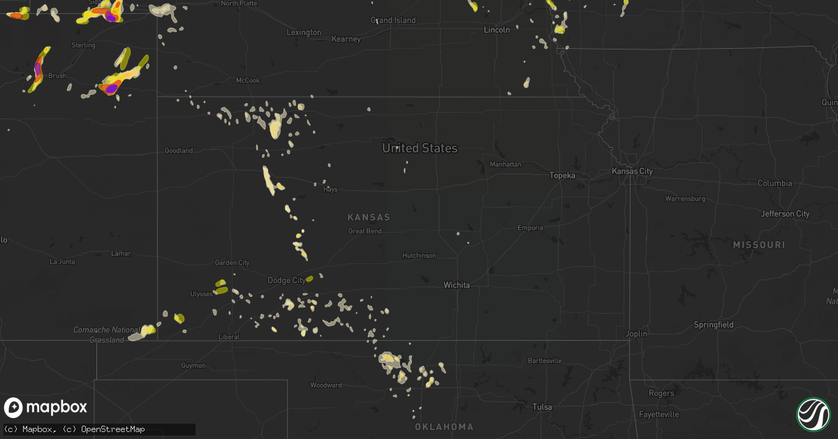
Hail Map in Kansas on June 6, 2018
Get this storm
June 6 map
$229
one time, instant access
Download today. No call, no setup
Keep the $229
Bought the map and want the full workflow? Apply the entire $229 to a subscription within 7 days. None of it is wasted.
Every map, not just this one
This buys you this map. Subscription and you get every map we run, in the markets you choose from a few cities to whole states to nationwide. Plus real-time alerts the moment a storm fires.
Contact data
Name, contact info, occupancy, even credit band for addresses in the footprint. You go from where it hit to who to call.
Become the source they trust
Unlimited branding weather history reports on demand. You already have the documented answer ready for the property owner, and you are the one who showed up with it.
Property data and RoofTrace estimates
Pull up any address you have got, its value and the exact code rules for that jurisdiction, straight from One Click Code. Then RoofTrace estimates the squares, pitch, and roof value, priced the way you price.
Storm reports in Kansas
Kansas
| Date | Description |
|---|---|
| 06/06/20186:01 AM CDT | At 1100 PM CDT, a severe thunderstorm was located 4 miles south of Feterita, moving east at 25 mph. HAZARD...60 mph wind gusts and half dollar size hail. SOURCE...Radar indicated. IMPACT...Hail damage to vehicles is expected. Expect wind damage to roofs, siding, and trees. This severe thunderstorm will remain over mainly rural areas of southeastern Morton and southern Stevens Counties. |
| 06/06/20185:34 AM CDT | At 1034 PM CDT, a severe thunderstorm was located 7 miles north of Rolla, moving east at 20 mph. HAZARD...Up to Golf ball size hail and 60 mph wind gusts. SOURCE...Radar indicated. IMPACT...People and animals outdoors will be injured. Expect hail damage to roofs, siding, windows, and vehicles. Expect wind damage to roofs, siding, and trees. Locations impacted include... Hugoton, Rolla, Richfield and Feterita. |
| 06/06/20184:15 AM CDT | At 914 PM MDT, severe thunderstorms were located along a line extending from 9 miles north of Enders to near Champion to 14 miles south of Lamar, moving southeast at 45 mph. HAZARD...60 mph wind gusts and quarter size hail. SOURCE...Radar indicated. IMPACT...Hail damage to vehicles is expected. Expect wind damage to roofs, siding, and trees. Locations impacted include... Benkelman, Haigler, Laird, Parks and Max. |
| 06/06/20183:26 AM CDT | At 826 PM CDT, a severe thunderstorm was located 11 miles south of Stonington, or 15 miles northwest of Elkhart, moving northeast at 20 mph. HAZARD...60 mph wind gusts and quarter size hail. SOURCE...Radar indicated. IMPACT...Hail damage to vehicles is expected. Expect wind damage to roofs, siding, and trees. Locations impacted include... Richfield. |
| 06/06/20182:48 AM CDT | Corrected to thunderstorm wind gust as some thunderstorms were still within the vicinity. |
| 06/06/20182:40 AM CDT | A local report indicates 67 MPH wind near 9 N STOCKTON |
| 06/06/20182:15 AM CDT | A local report indicates 62 MPH wind near 1 W LOGAN |
| 06/06/20182:05 AM CDT | Propane tank and grill slammed against the wall. Heavy glass patio table flipped and shattered. Chairs blown somewhere to the east. |
| 06/06/20182:01 AM CDT | A local report indicates 74 MPH wind near 1 ENE HILL CITY |
| 06/06/20182:00 AM CDT | Corrected report type to thunderstorm wind gusts as thunderstorms were still within the vicinity. |
| 06/06/20181:10 AM CDT | Tree uprooted in downtown cimarron. Roof damage also reported at this time. |
| 06/06/20181:00 AM CDT | Corrects event type to thunderstorm wind gust as thunderstorms were immediately south of observation site. Also corrected event to a time 15 min earlier per observation |
| 06/06/201812:50 AM CDT | Tin roof blown off a barn. |
| 06/06/201812:48 AM CDT | Corrects event type to thunderstorm wind gust as thunderstorms were immediately south of observation site at event time. |
| 06/06/201812:35 AM CDT | Mesonet station ks010... 1 ene garden city. |
| 06/05/201811:45 PM CDT | A local report indicates 1.00 inch wind near 6 N TICE |
| 06/05/201811:30 PM CDT | Portion of roof on new construction torn off. Several irrigation pivot systems flipped in that area as well. |
| 06/05/201811:12 PM CDT | Corrects previous tstm wnd gst report from hugoton. |
| 06/05/201811:05 PM CDT | Emergency manager reported an unoccupied trailer was destroyed 2.5 miles north of hugoton on road 12. |
| 06/05/201811:05 PM CDT | Several tree branches downed and shingles blown off homes. |
| 06/05/201811:05 PM CDT | A local report indicates 1.00 inch wind near 10 WNW MOSCOW |
| 06/05/201811:05 PM CDT | Corrects previous hail report from 10 wnw moscow to thunderstorm wind gust. |
| 06/05/201811:02 PM CDT | Airport hanger had doors blown off by wind. |
| 06/05/201811:01 PM CDT | Corrects event type to thunderstorm wind gust and report source to awos. |
| 06/05/201811:00 PM CDT | A 500 gallon fertilizer tank blown over and rolled by wind. |
| 06/05/201810:55 PM CDT | Grain bin collapsed by strong wind. |
| 06/05/201810:50 PM CDT | A local report indicates 1.00 inch wind near 8 NNE RYUS |
| 06/05/20189:10 PM CDT | At 210 AM MDT, a severe thunderstorm was located 14 miles northwest of Sharon Springs, moving northeast at 25 mph. HAZARD...Golf ball size hail and 60 mph wind gusts. SOURCE...Radar indicated. IMPACT...People and animals outdoors will be injured. Expect hail damage to roofs, siding, windows, and vehicles. Expect wind damage to roofs, siding, and trees. This severe thunderstorm will remain over mainly rural areas of northwestern Wallace and southeastern Sherman Counties.This includes Interstate 70 in Kansas between mile markers 24 and 25. |
All States Impacted by Hail Map on June 6, 2018
Cities Impacted by Hail Map on June 6, 2018
- Platte, SD
- Spalding, NE
- Anita, IA
- Casey, IA
- Exira, IA
- Adair, IA
- Menlo, IA
- Stuart, IA
- Pacific Junction, IA
- Glenwood, IA
- Madrid, IA
- Boone, IA
- Ames, IA
- Thermopolis, WY
- Maxwell, IA
- Cambridge, IA
- Vail, IA
- Westside, IA
- Manilla, IA
- Aspinwall, IA
- Arcadia, IA
- Manning, IA
- Clive, IA
- Des Moines, IA
- Grimes, IA
- Urbandale, IA
- Johnston, IA
- West Des Moines, IA
- Windsor Heights, IA
- Coffee Creek, MT
- Stanford, MT
- Crook, CO
- Sidney, NE
- Lodgepole, NE
- Webster City, IA
- East Moline, IL
- Hubbard, IA
- West Point, NE
- Maquoketa, IA
- Fonda, IA
- Newell, IA
- Jolley, IA
- Sac City, IA
- Pine Bluffs, WY
- Carpenter, WY
- Grover, CO
- Hereford, CO
- Dresden, KS
- Clayton, KS
- Selden, KS
- Jennings, KS
- Norton, KS
- Norcatur, KS
- Grundy Center, IA
- Peetz, CO
- Laramie, WY
- Kremlin, OK
- Enid, OK
- Fowler, KS
- Kadoka, SD
- Cherokee, OK
- Clearmont, WY
- Banner, WY
- Wyarno, WY
- Radcliffe, IA
- Ainsworth, NE
- Whitman, NE
- Jetmore, KS
- Ransom, KS
- Ashland, KS
- Goltry, OK
- Helena, OK
- Hunter, OK
- Mapleton, IA
- Castana, IA
- San Simon, AZ
- Linwood, NE
- Prague, NE
- Bushnell, NE
- Ashby, NE
- Oshkosh, NE
- Ogallala, NE
- Rockwell City, IA
- Burke, SD
- Duncombe, IA
- Clarks, NE
- Padroni, CO
- Eckley, CO
- Wray, CO
- Yuma, CO
- Otis, CO
- Hanston, KS
- Minneola, KS
- Ogden, IA
- Perry, IA
- Woodward, IA
- Bouton, IA
- Quinter, KS
- Oakland, NE
- Craig, NE
- Campo, CO
- Walsh, CO
- Traer, IA
- Lewistown, MT
- Buffalo, WY
- Ankeny, IA
- Sedgwick, CO
- Chappell, NE
- Dallas Center, IA
- Adel, IA
- Waukee, IA
- Denton, MT
- Collyer, KS
- Liscomb, IA
- Chinook, MT
- Lloyd, MT
- Humbird, WI
- Fairchild, WI
- Penokee, KS
- Hill City, KS
- Pilger, NE
- Beemer, NE
- Wisner, NE
- Dodge, NE
- Winner, SD
- Gordon, NE
- Fontanelle, IA
- Columbus, NE
- Irwin, IA
- Atwood, KS
- Eagle Grove, IA
- Goldfield, IA
- Clarion, IA
- Howells, NE
- Eldora, IA
- Rippey, IA
- Jamaica, IA
- Jefferson, IA
- Lake City, IA
- Farnhamville, IA
- Paton, IA
- Churdan, IA
- Lohrville, IA
- Pomeroy, IA
- Marathon, TX
- Bingham, NE
- Ellsworth, NE
- Hillsboro, KS
- Audubon, IA
- Fort Morgan, CO
- Weldona, CO
- Bosler, WY
- Emerson, IA
- Red Oak, IA
- Fort Dodge, IA
- Manson, IA
- Gilmore City, IA
- Palmer, IA
- Clare, IA
- Barnum, IA
- Dwight, NE
- Bee, NE
- Livingston, MT
- Bassett, NE
- Morland, KS
- Bucklin, KS
- Granger, IA
- Nashville, KS
- Sharon, KS
- Medicine Lodge, KS
- Sublette, KS
- Newman Grove, NE
- Albion, NE
- Cedar Rapids, NE
- Holyoke, CO
- North Bend, NE
- Morse Bluff, NE
- Corning, IA
- Conrad, IA
- Petersburg, NE
- Ericson, NE
- Greeley, NE
- Norfolk, NE
- Hoskins, NE
- Stanton, NE
- Bellwood, NE
- Geraldine, MT
- Humphrey, NE
- Ness City, KS
- Ellis, KS
- Randall, IA
- Ellsworth, IA
- Story City, IA
- Stratford, IA
- Stanhope, IA
- Jewell, IA
- Reinbeck, IA
- Toledo, IA
- Clutier, IA
- Buckingham, IA
- Dysart, IA
- Gladbrook, IA
- Ten Sleep, WY
- Montour, IA
- Tama, IA
- Atkinson, NE
- Clarkson, NE
- Leigh, NE
- Primrose, NE
- Port Byron, IL
- Geneseo, IL
- Hillsdale, IL
- Syracuse, NE
- Talmage, NE
- Almena, KS
- Moscow, KS
- Lehigh, IA
- Otho, IA
- David City, NE
- Angora, NE
- Alliance, NE
- Bridgewater, IA
- Massena, IA
- New Raymer, CO
- Otter, MT
- Birney, MT
- Earlham, IA
- Lenora, KS
- Carroll, IA
- Haxtun, CO
- Bazine, KS
- Saint Edward, NE
- Fullerton, NE
- Belgrade, NE
- Genoa, NE
- Atlantic, IA
- Brayton, IA
- Plains, KS
- Otley, IA
- Lyons, NE
- Scribner, NE
- Minburn, IA
- Yale, IA
- Slater, IA
- Polk City, IA
- Alleman, IA
- Linden, IA
- Scranton, IA
- Redfield, IA
- Grand Junction, IA
- Dawson, IA
- Huxley, IA
- Panora, IA
- Omaha, NE
- Hoxie, KS
- Beaman, IA
- Lincoln, IA
- Pittsville, WI
- Bancroft, IA
- Preston, IA
- Malvern, IA
- White River, SD
- Eagle, NE
- Alvo, NE
- McDonald, KS
- Ludell, KS
- Somers, IA
- Schuyler, NE
- Percival, IA
- Thurman, IA
- Tabor, IA
- Sidney, IA
- Silver Creek, NE
- Niobrara, NE
- Cody, WY
- Kamrar, IA
- Garden City, IA
- Pilot Mound, IA
- Big Springs, NE
- Gilbert, IA
- Luther, IA
- Meadow Grove, NE
- Tilden, NE
- Copeland, KS
- Madison, NE
- Snyder, NE
- Wall, SD
- Greenfield, IA
- Winterset, IA
- Orient, IA
- Bridgeport, NE
- Lindsay, NE
- Haviland, KS
- Wilmore, KS
- Sun City, KS
- Kelley, IA
- Nevada, IA
- Dexter, IA
- Coldwater, KS
- Brule, NE
- Venango, NE
- Grant, NE
- Julesburg, CO
- Kimball, SD
- Pukwana, SD
- Oberlin, KS
- Park, KS
- Thor, IA
- Meade, KS
- Rushville, NE
- Pawnee City, NE
- Steinauer, NE
- Burchard, NE
- Morrison, IA
- Garwin, IA
- Marshalltown, IA
- Rock Port, MO
- Hamburg, IA
- Mullinville, KS
- Glen Elder, KS
- Richfield, KS
- Camp Douglas, WI
- Tekamah, NE
- Hennessey, OK
- Worland, WY
- Carmen, OK
- Cascade, IA
- Denison, IA
- Monroe, IA
- Silver City, IA
- Hay Springs, NE
- Bryant, IA
- Goose Lake, IA
- Hardy, IA
- Albion, IA
- Lahoma, OK
- Meno, OK
- Madrid, NE
- Peabody, KS
- New Providence, IA
- Union, IA
- Whitten, IA
- Ottosen, IA
- Geddes, SD
- Rutland, IA
- Humboldt, IA
- Elberon, IA
- Chelsea, IA
- Plainville, KS
- Hardtner, KS
- Wisconsin Dells, WI
- Dacoma, OK
- Alva, OK
- Burlington, OK
- Burwell, NE
- Pritchett, CO
- Broadwater, NE
- Lehigh, KS
- Wakeeney, KS
- Dallas, SD
- Nebraska City, NE
- Ideal, SD
- Gretna, NE
- Springfield, NE
- Vincent, IA
- Sheridan, WY
- Bellevue, NE
- Offutt Afb, NE
- Whitehall, WI
- Belvidere, SD
- Davenport, IA
- Meeteetse, WY
- Gilman, IA
- Newton, IA
- Guthrie Center, IA
- Louisville, NE
- Weeping Water, NE
- Manley, NE
- Murdock, NE
- Reedsburg, WI
- Lyndon Station, WI
- Baraboo, WI
- Moorhead, IA
- Homestead, FL
- Rogers, NE
- Kimball, NE
- Mount Horeb, WI
- Algona, IA
- Whittemore, IA
- West Bend, IA
- Decatur, NE
- Purdum, NE
- Brewster, NE
- Lincoln, KS
- Decker, MT
- Danbury, IA
- Blair, WI
- Ismay, MT
- Big Sandy, MT
- Arthur, NE
- Holmen, WI
- Woolstock, IA
- Badger, IA
- Ulysses, NE
- Brainard, NE
- Creston, NE
- Bruno, NE
- Stockton, KS
- Arena, WI
- Hays, MT
- Sterling, NE
- Ringwood, OK
- Jet, OK
- Spring Green, WI
- Johnstown, NE
- Scotia, NE
- Griswold, IA
- Hyannis, NE
- Macedonia, IA
- Carson, IA
- Montezuma, KS
- Pond Creek, OK
- Akron, CO
- Offerle, KS
- Kinsley, KS
- Volborg, MT
- Sawyer, KS
- Thedford, NE
- New Lisbon, WI
- Mauston, WI
- Renwick, IA
- Bradgate, IA
- Dell Rapids, SD
- Garretson, SD
- Reasnor, IA
- Barnard, KS
- Chamberlain, SD
- Laurel, IA
- Haverhill, IA
- Ford, KS
- Elkhart, KS
- Mazomanie, WI
- Sauk City, WI
- Smith Center, KS
- Bird City, KS
- Champion, NE
- Monroe, NE
- Rock River, WY
- Council Bluffs, IA
- Wiggins, CO
- Lamont, OK
- Garden City, KS
- Gregory, SD
- Protection, KS
- Cleo Springs, OK
- Le Grand, IA
- Summerland Key, FL
- Valparaiso, NE
- Jupiter, FL
- Hazelton, KS
- Verdigre, NE
- Princeton, IA
- Montezuma, IA
- Brodhead, WI
- Monroe, WI
- Albany, WI
- Soldier, IA
- Rising City, NE
- Ulysses, KS
- Satanta, KS
- Ames, OK
- Kaycee, WY
- Callender, IA
- Gowrie, IA
- Benkelman, NE
- Coon Rapids, IA
- Walcott, IA
- Wellsburg, IA
- Steamboat Rock, IA
- Holland, IA
- Iowa Falls, IA
- Garber, OK
- Byers, CO
- Tryon, NE
- Hemingford, NE
- Stamford, NE
- Long Island, KS
- Knoxville, IA
- Brooklyn, IA
- Liberty, NE
- Wymore, NE
- Kismet, KS
- Winside, NE
- Platte Center, NE
- Tomah, WI
- Saint Francis, KS
- Otoe, NE
- Dunbar, NE
- Lordsburg, NM
- Rolla, KS
- Wonewoc, WI
- La Valle, WI
- Wood River, NE
- Nash, OK
- Randolph, IA
- Albert City, IA
- Kiowa, KS
- Hustler, WI
- Hamlin, IA
- Elk Horn, IA
- Kimballton, IA
- Prescott, IA
- Coats, KS
- Hays, KS
- Witten, SD
- Abie, NE
- Dannebrog, NE
- Boelus, NE
- Manchester, OK
- Bennett, CO
- Strasburg, CO
- Drummond, OK
- Ute, IA
- Onawa, IA
- Mullen, NE
- Spearville, KS
- Pocahontas, IA
- Blairsburg, IA
- Vinton, IA
- Mount Auburn, IA
- Bussey, IA
- Tracy, IA
- Hooppole, IL
- Prophetstown, IL
- Kenneth, MN
- Wilmont, MN
- Lismore, MN
- Adrian, MN
- Rushmore, MN


