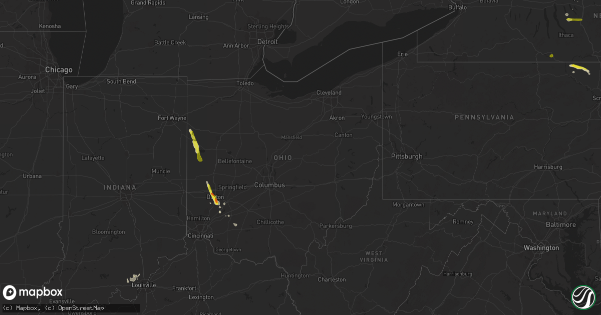
Hail Map in Ohio on June 5, 2017
Get this storm
June 5 map
$229
one time, instant access
Download today. No call, no setup
Keep the $229
Bought the map and want the full workflow? Apply the entire $229 to a subscription within 7 days. None of it is wasted.
Every map, not just this one
This buys you this map. Subscription and you get every map we run, in the markets you choose from a few cities to whole states to nationwide. Plus real-time alerts the moment a storm fires.
Contact data
Name, contact info, occupancy, even credit band for addresses in the footprint. You go from where it hit to who to call.
Become the source they trust
Unlimited branding weather history reports on demand. You already have the documented answer ready for the property owner, and you are the one who showed up with it.
Property data and RoofTrace estimates
Pull up any address you have got, its value and the exact code rules for that jurisdiction, straight from One Click Code. Then RoofTrace estimates the squares, pitch, and roof value, priced the way you price.
Storm reports in Ohio
Ohio
| Date | Description |
|---|---|
| 06/05/20175:30 PM CDT | A local report indicates 1.00 inch wind near ENE CENTERVILLE |
| 06/05/20175:27 PM CDT | Large tree downed in village south park. Time estimated by radar. |
| 06/05/20175:25 PM CDT | Based on photo from social media. Time estimated by radar. |
| 06/05/20175:24 PM CDT | Time estimated by radar. |
| 06/05/20175:22 PM CDT | Large tree downed in kettering. Time estimated by radar. |
| 06/05/20175:22 PM CDT | A tree snapped and a few large limbs down near irelan park near marshall rd. Time estimated by radar. |
| 06/05/20175:12 PM CDT | Hail estimated from social media photo. Time estimated by radar. |
| 06/05/20175:04 PM CDT | Large tree down on redder ave. Time estimated by radar. |
| 06/05/20174:59 PM CDT | Time estimated by radar. |
| 06/05/20174:51 PM CDT | A local report indicates 1.25 inch wind near ENGLEWOOD |
| 06/05/20174:33 PM CDT | Large tree split in half. Time estimated by radar. |
| 06/05/20174:31 PM CDT | Several large trees and powerpoles down near horseshoe bend rd. Barn heavily damaged. Additional powerlines downed near ellemen rd. Time estimated by radar. |
| 06/05/20174:09 PM CDT | Several trees downed and a barn damaged in camp creek township. Time estimated by radar. |
| 06/05/20173:40 PM CDT | A local report indicates 1.00 inch wind near MARIA STEIN |
| 06/05/20173:11 PM CDT | Report from mercer county emergency management. |
| 06/05/20173:03 PM CDT | Tree down across the road at oregon road and township line road. Time estimated by radar. |
| 06/05/20172:53 PM CDT | Several tree limbs 7 to 8 inches in diameter downed in rockford area. Time estimated by radar. |
| 06/05/20172:50 PM CDT | Tree limb down. |
| 06/05/20172:40 PM CDT | Telephone poles snapped and lines down. |
| 06/05/20172:30 PM CDT | Also reported torrential rain. Location was on foster school road |
| 06/05/20172:17 PM CDT | Tree limb down near intersection of w. Taylor school road and brooks rd. Time estimated by radar. |
| 06/05/20172:15 PM CDT | A local report indicates 1.00 inch wind near 2 NNW CONVOY |
All States Impacted by Hail Map on June 5, 2017
Cities Impacted by Hail Map on June 5, 2017
- Ralph, SD
- Model, CO
- Branson, CO
- Trinidad, CO
- Douglas, WY
- San Perlita, TX
- Los Fresnos, TX
- Rio Hondo, TX
- Dayton, OH
- Friendsville, PA
- Montrose, PA
- New Raymer, CO
- Huggins, MO
- Graff, MO
- Mountain Grove, MO
- Plato, MO
- Tilden, TX
- Elida, NM
- Crosby, ND
- Armstrong, TX
- Chadron, NE
- Lead, SD
- Roma, TX
- Perryville, MO
- Rawlins, WY
- Rockport, TX
- Gatesville, TX
- Strasburg, CO
- Roggen, CO
- Waynesville, OH
- Mud Butte, SD
- Linn, TX
- Ten Sleep, WY
- Rio Grande City, TX
- Casper, WY
- Mora, NM
- Hulett, WY
- Deadwood, SD
- Moravia, NY
- Locke, NY
- New Vienna, OH
- Martinsville, OH
- Hillsboro, OH
- Lynchburg, OH
- Refugio, TX
- Goliad, TX
- Hill City, SD
- Custer, SD
- Newcastle, WY
- Raymondville, TX
- Falfurrias, TX
- Premont, TX
- Kilmichael, MS
- Cuero, TX
- Three Rivers, TX
- Realitos, TX
- Alcova, WY
- Upton, WY
- Mirando City, TX
- Laredo, TX
- Orange Grove, TX
- Rome, PA
- Englewood, OH
- Borden, IN
- Oelrichs, SD
- Oilton, TX
- Hay Springs, NE
- Sundance, WY
- Floyds Knobs, IN
- Woodsboro, TX
- Aransas Pass, TX
- Jonesboro, TX
- Warren Center, PA
- Le Raysville, PA
- Athens, PA
- Little Meadows, PA
- Bayside, TX
- Ingleside, TX
- Taft, TX
- Skaneateles, NY
- Grover, CO
- Mendon, OH
- Celina, OH
- Rockford, OH
- Lance Creek, WY
- Gillette, WY
- Coldwater, OH
- Alice, TX
- Watkins, CO
- Cuervo, NM
- Chugwater, WY
- Ohio City, OH
- Wilmington, OH
- Clarksville, OH
- Buffalo, SD
- Wiggins, CO
- Evansville, WY
- Van Wert, OH
- Convoy, OH
- Encino, TX
- Corpus Christi, TX
- Bishop, TX
- Robstown, TX
- Bellbrook, OH
- Spring Valley, OH
- Rociada, NM
- Sapello, NM
- Buena Vista, NM
- Sentinel Butte, ND
- Keystone, SD
- Jefferson, NY
- Syracuse, NY
- Bennett, CO
- Chester, IL
- Rockwood, IL
- Edgemont, SD
- West Milton, OH
- Rapid City, SD
- Sumter, SC
- Jourdanton, TX
- Hot Springs, SD
- Glenrock, WY
- Crandall, IN
- New Salisbury, IN
- Palmyra, IN
- Gonzales, TX
- Prairie City, SD
- Guffey, CO
- Cherry Creek, SD
- Alva, WY
- Bassett, NE
- Greenfield, OH
- Buda, TX
- Manchaca, TX
- Hermosa, SD
- Greenville, IN
- Georgetown, IN
- Lyford, TX
- Ludlow Falls, OH
- Bushnell, NE
- Weldona, CO
- Orchard, CO
- Riviera, TX
- Calliham, TX
- George West, TX
- Ludlow, SD
- Summit, NY
- Stamford, NY
- Roswell, NM
- Seguin, TX
- Timberon, NM
- Las Vegas, NM
- Osage, WY
- Vaughn, NM
- Bowman, ND
- Clayton, OH
- Xenia, OH
- Aurora, CO
- Thermopolis, WY
- Cloudcroft, NM
- Ulster, PA
- Miamisburg, OH
- Scandia, KS
- Weston, CO
- Carrizozo, NM
- Floresville, TX
- Gordon, NE
- Faith, SD
- Harrisburg, NE
- Trinchera, CO
- Bruni, TX
- Concepcion, TX
- Kingsville, TX
- Willshire, OH
- Springer, NM
- Poteet, TX
- Reva, SD
- Leesburg, OH
- Wysox, PA
- Yorktown, TX
- Alamo, ND
- Garita, NM
- Ainsworth, NE
- Montezuma, OH
- Saint Henry, OH
- Maria Stein, OH
- Vandalia, OH
- Troy, OH
- Sarita, TX
- Rhame, ND
- Camp Crook, SD
- Homer, NY
- Little York, NY
- Cortland, NY
- Elmira, NY


