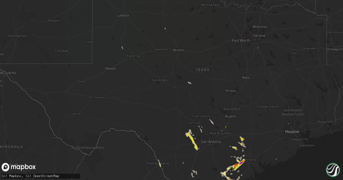
Hail Map in Texas on June 4, 2017
Get this storm
June 4 map
$229
one time, instant access
Download today. No call, no setup
Keep the $229
Bought the map and want the full workflow? Apply the entire $229 to a subscription within 7 days. None of it is wasted.
Every map, not just this one
This buys you this map. Subscription and you get every map we run, in the markets you choose from a few cities to whole states to nationwide. Plus real-time alerts the moment a storm fires.
Contact data
Name, contact info, occupancy, even credit band for addresses in the footprint. You go from where it hit to who to call.
Become the source they trust
Unlimited branding weather history reports on demand. You already have the documented answer ready for the property owner, and you are the one who showed up with it.
Property data and RoofTrace estimates
Pull up any address you have got, its value and the exact code rules for that jurisdiction, straight from One Click Code. Then RoofTrace estimates the squares, pitch, and roof value, priced the way you price.
Storm reports in Texas
Texas
| Date | Description |
|---|---|
| 06/04/20176:18 PM CDT | Quarter size hail falling in goliad |
| 06/04/20176:17 PM CDT | A local report indicates 2.75 inch wind near 7 NE GOLIAD |
| 06/04/20176:11 PM CDT | Images submitted of wooden gazebo destroyed and blown into road |
| 06/04/20176:09 PM CDT | Images submitted of a large tree blown onto and heavily damaging a car |
| 06/04/20176:06 PM CDT | Alameda and airline intersection |
| 06/04/20176:03 PM CDT | Alameda and airline intersection. Corrected for location and time |
| 06/04/20175:55 PM CDT | Relayed to emc by westoff fire dept officials. |
| 06/04/20175:55 PM CDT | Photos reveal a large metal storage roof was ripped from its structure and wrapped around a nearby large tree. Large tree branches torn off. |
| 06/04/20175:54 PM CDT | Images submitted of large tree blown down next to house |
| 06/04/20175:23 PM CDT | A local report indicates 60 MPH wind near CORPUS CHRISTI |
| 06/03/201710:45 PM CDT | Brooks county so reported golf ball size hail 5 miles east of highway 281 on e 285. |
| 06/03/201710:45 PM CDT | Brooks county sheriffs office reported golf ball size hail 5 miles east of us 281 along sr 285. |
| 06/03/201710:24 PM CDT | High thunderstorm wind gusts near hwy 173 and fm1343 during travel to devine. |
| 06/03/201710:06 PM CDT | Several people trapped in an overturned mobile home or trailer. Injuries unknown |
| 06/03/201710:06 PM CDT | Several people trapped in an overturned mobile home or trailer. Injuries unknown |
| 06/03/20179:47 PM CDT | Asos peak wind gust from the north. Fastest 2-minute wind speed was 54 mph from the north. |
| 06/03/20178:55 PM CDT | Pea size hail occurred along with high wind gusts. |
| 06/03/20178:50 PM CDT | A local report indicates 70 MPH wind near 4 SW CHRISTOVAL |
| 06/03/20178:25 PM CDT | A local report indicates 1.00 inch wind near GOLIAD |
| 06/03/20178:25 PM CDT | A local report indicates 60 MPH wind near GOLIAD |
| 06/03/20177:12 PM CDT | Quarter to half dollar size hail in pic |
All States Impacted by Hail Map on June 4, 2017
Cities Impacted by Hail Map on June 4, 2017
- Corpus Christi, TX
- Terrell, NC
- Denver, NC
- Davidson, NC
- Cornelius, NC
- Mooresville, NC
- Woodville, AL
- Mountain, WI
- White Lake, WI
- Townsend, WI
- Goliad, TX
- Odem, TX
- Mathis, TX
- Sinton, TX
- Devine, TX
- Lohn, TX
- Falfurrias, TX
- Eagle Pass, TX
- Beeville, TX
- Suffolk, VA
- Henderson, NC
- Nathalie, VA
- Caro, MI
- Great Falls, MT
- Pickerel, WI
- Columbus, MT
- Gonzales, TX
- Crystal City, TX
- Bishop, TX
- Nova, OH
- Sullivan, OH
- Shiner, TX
- Yoakum, TX
- Medina, TX
- Blanco, TX
- Locust, NC
- Mount Pleasant, NC
- Concord, NC
- San Diego, TX
- Smiley, TX
- East Alton, IL
- Cottage Hills, IL
- Wood River, IL
- Taft, TX
- Concepcion, TX
- Victoria, TX
- Hartford, IL
- Cuero, TX
- George West, TX
- Encino, TX
- Comfort, TX
- Wentzville, MO
- Thomasville, NC
- Riviera, TX
- Rockport, TX
- Hondo, TX
- Kannapolis, NC
- Pound, WI
- Denton, MT
- Stockett, MT
- Cut Bank, MT
- Realitos, TX
- New Braunfels, TX
- D Hanis, TX
- Bonaire, GA
- Kathleen, GA
- Alice, TX
- Bandera, TX
- Fitzgerald, GA
- Kingsville, TX
- East Glacier Park, MT
- Glade Hill, VA
- Boerne, TX
- Pipe Creek, TX
- Taylorsville, NC
- Aspermont, TX
- South Range, WI
- Superior, WI
- Littleton, NC
- Macon, NC
- Churubusco, IN
- Perry, GA
- Armstrong, TX
- Denton, GA
- West Green, GA
- Highwood, MT
- Premont, TX
- Utopia, TX
- Tarpley, TX
- Sand Coulee, MT
- Belt, MT
- Bellefontaine, OH
- Emmett, ID
- Lyman, SC
- Inman, SC
- Campobello, SC
- Moore, TX
- Drummond, MT
- Clinton, MT
- Huntersville, NC
- Cotulla, TX
- Sandia, TX
- Robstown, TX
- Albion, IN
- Continental, OH
- Leipsic, OH
- Spring, TX
- Union Hall, VA
- Ferris, TX
- San Perlita, TX
- Nashville, NC
- Spring Hope, NC
- Monroe, NC
- Runge, TX
- Nordheim, TX
- North Manchester, IN
- Huntington, IN
- Bay City, TX
- Java, VA
- Gretna, VA
- Yorktown, TX
- Nixon, TX
- Midland, NC
- Lyford, TX
- Bonner, MT
- Elk City, ID
- Skidmore, TX
- Woodsboro, TX
- Tynan, TX
- Three Rivers, TX
- Meyersville, TX
- Refugio, TX
- Rocky Mount, VA
- Encinal, TX
- Mansfield, OH
- Lamesa, TX
- Sarah, MS
- Bourbon, IN
- Greer, SC
- Etna Green, IN
- Crestline, OH
- Shelby, OH
- Aransas Pass, TX
- Plymouth, IN
- Argos, IN
- Westhoff, TX
- Tarzan, TX
- Lenorah, TX
- Akron, MI
- Cass City, MI
- Raymondville, TX
- Warrenton, NC
- Floweree, MT
- San Marcos, TX


