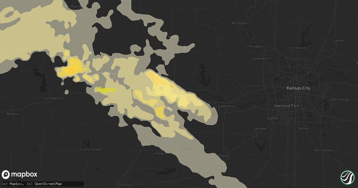
Hail Map in Topeka, KS on June 4, 2015
Get this storm
June 4 map
$229
one time, instant access
Download today. No call, no setup
Keep the $229
Bought the map and want the full workflow? Apply the entire $229 to a subscription within 7 days. None of it is wasted.
Every map, not just this one
This buys you this map. Subscription and you get every map we run, in the markets you choose from a few cities to whole states to nationwide. Plus real-time alerts the moment a storm fires.
Contact data
Name, contact info, occupancy, even credit band for addresses in the footprint. You go from where it hit to who to call.
Become the source they trust
Unlimited branding weather history reports on demand. You already have the documented answer ready for the property owner, and you are the one who showed up with it.
Property data and RoofTrace estimates
Pull up any address you have got, its value and the exact code rules for that jurisdiction, straight from One Click Code. Then RoofTrace estimates the squares, pitch, and roof value, priced the way you price.
Storm reports in Topeka, KS
Topeka, KS
| Date | Description |
|---|---|
| 06/03/201510:02 PM CDT | Report of a 72 mph wind gust measured by an anemometer |
| 06/03/20159:45 PM CDT | Spotter called to report he did have 18 inch tree limbs broken off of a huckleberry tree that was a healthy tree. |
| 06/03/20159:42 PM CDT | A local report indicates 1.25 inch wind near 3 W TOPEKA |
| 06/03/20159:34 PM CDT | A local report indicates 1.00 inch wind near 4 WSW TOPEKA |
| 06/03/20159:24 PM CDT | 27th and wanamaker. |
| 06/03/20159:18 PM CDT | A local report indicates 60 MPH wind near 3 SSE SILVER LAKE |
All States Impacted by Hail Map on June 4, 2015
All Cities Impacted by Hail Map on June 4, 2015
- Selden, KS
- Pecos, TX
- Dalhart, TX
- Texhoma, OK
- Randolph, KS
- Ramah, CO
- Clyde, KS
- Clay Center, KS
- Clifton, KS
- Miltonvale, KS
- Leonardville, KS
- Green, KS
- Linn, KS
- Greenleaf, KS
- Barnes, KS
- Palmer, KS
- Morganville, KS
- Riley, KS
- Ward, CO
- Colorado Springs, CO
- Lyons, CO
- Longmont, CO
- Berthoud, CO
- Rossville, KS
- Tecumseh, KS
- Topeka, KS
- Silver Lake, KS
- Doniphan, NE
- Auburn, NE
- Humboldt, NE
- Phillipsburg, KS
- Benedict, NE
- Marquette, NE
- Waco, NE
- Beaver Crossing, NE
- Bradshaw, NE
- Henderson, NE
- Seward, NE
- Polk, NE
- Hordville, NE
- Utica, NE
- York, NE
- Gresham, NE
- Hampton, NE
- Stromsburg, NE
- Holton, KS
- Richlands, NC
- Dighton, KS
- Quinter, KS
- Gove, KS
- Hartley, TX
- Denver, CO
- Aurora, CO
- Commerce City, CO
- Littleton, CO
- Englewood, CO
- Danbury, NE
- Harvard, NE
- Simla, CO
- Agate, CO
- Goff, KS
- Central City, NE
- Chapman, NE
- Taiban, NM
- House, NM
- Wilsonville, NE
- Hendley, NE
- Norton, KS
- Saint Marys, KS
- Emmett, KS
- Belvue, KS
- Wamego, KS
- Niwot, CO
- Friend, NE
- Dorchester, NE
- Crete, NE
- Atlanta, NE
- Holdrege, NE
- Burlingame, KS
- Scranton, KS
- Flagler, CO
- Salem, NE
- Morrill, KS
- Loma, MT
- Hoxie, KS
- Atwood, KS
- Kiowa, CO
- Van Horn, TX
- Salt Flat, TX
- Stratford, TX
- Gruver, TX
- Shelton, NE
- Bard, NM
- San Jon, NM
- Anton, CO
- Auburn, KS
- Douglas, WY
- Big Sandy, MT
- Olsburg, KS
- Waterville, KS
- Manhattan, KS
- Blue Rapids, KS
- Saint George, KS
- Hastings, NE
- Table Rock, NE
- Arvada, CO
- Golden, CO
- Weskan, KS
- Centralia, KS
- Wheatland, WY
- Sutton, NE
- Edgar, NE
- Westminster, CO
- Channing, TX
- Hill City, KS
- Hartville, WY
- Glendo, WY
- Jay Em, WY
- Minneapolis, KS
- Unadilla, NE
- Palmyra, NE
- Wellington, CO
- Fort Collins, CO
- Houstonia, MO
- Alda, NE
- Wood River, NE
- Platteville, CO
- Loveland, CO
- Boulder, CO
- Milliken, CO
- Johnstown, CO
- Mead, CO
- Dodge City, KS
- Lawrence, NE
- Lebanon, NE
- Concordia, KS
- Aurora, KS
- Morrowville, KS
- Endicott, NE
- Haddam, KS
- Odell, NE
- Cuba, KS
- Narka, KS
- Marysville, KS
- Fairbury, NE
- Hollenberg, KS
- Hanover, KS
- Steele City, NE
- Bremen, KS
- Belleville, KS
- Liberty, NE
- Washington, KS
- Mahaska, KS
- Diller, NE
- Barneston, NE
- Wymore, NE
- Bosler, WY
- Meeteetse, WY
- Geneva, NE
- Herndon, KS
- Vernon, CO
- Grainfield, KS
- Crab Orchard, NE
- Tecumseh, NE
- Osage City, KS
- Harveyville, KS
- Saint Joseph, MO
- Rushville, MO
- Eskridge, KS
- Broomfield, CO
- Matheson, CO
- Ludell, KS
- Fort Benton, MT
- Chester, MT
- Copeland, KS
- McDonald, KS
- Thermopolis, WY
- Pavillion, WY
- Riverton, WY
- Alexandria, NE
- Daykin, NE
- Trumbull, NE
- Quenemo, KS
- Pomona, KS
- Williamsburg, KS
- Melvern, KS
- Dawson, NE
- Stella, NE
- Shubert, NE
- Peru, NE
- Verdon, NE
- Nemaha, NE
- Johnson, NE
- Brownville, NE
- Fortuna, MO
- Versailles, MO
- Bogue, KS
- Stockton, KS
- Milford, NE
- Blue Hill, NE
- Elbert, CO
- Calhan, CO
- Adams, NE
- Sterling, NE
- Cheyenne, WY
- Grand Island, NE
- Jamestown, KS
- Arriba, CO
- Axtell, NE
- Latham, MO
- Loup City, NE
- Florence, MO
- Syracuse, MO
- Berryton, KS
- Delia, KS
- Lecompton, KS
- Seibert, CO
- Park, KS
- Ottawa, KS
- Logan, KS
- Lane, KS
- Richmond, KS
- Greeley, KS
- Garnett, KS
- Iberia, MO
- Morland, KS
- Kinnear, WY
- Onaga, KS
- Artesia, NM
- Lake Arthur, NM
- Kirk, CO
- Laramie, WY
- Belle, MO
- Hays, KS
- Alpine, TX
- Concordia, MO
- Wilber, NE
- Clatonia, NE
- Aurora, NE
- Yeso, NM
- Gibbon, NE
- Eldon, MO
- Kenesaw, NE
- Holstein, NE
- Grafton, NE
- Montezuma, KS
- Beloit, KS
- Delphos, KS
- Glasco, KS
- Lenora, KS
- Franklin, NE
- Otterville, MO
- Garrett, WY
- Hebron, NE
- Hubbell, NE
- Alma, KS
- Sharon Springs, KS
- Agenda, KS
- Spearville, KS
- Offerle, KS
- Dixon, MO
- Beatrice, NE
- Frankfort, KS
- Vona, CO
- Stratton, CO
- Scandia, KS
- Carbondale, KS
- Wathena, KS
- De Kalb, MO
- Troy, KS
- Atchison, KS
- Hazard, NE
- Pleasanton, NE
- Ravenna, NE
- Wray, CO
- Bell, FL
- Maple Hill, KS
- Westmoreland, KS
- Saint Charles, MO
- Saint Peters, MO
- O'Fallon, MO
- Goodwell, OK
- Boise City, OK
- Mcalister, NM
- Arcadia, NE
- Parker, CO
- Elizabeth, CO
- Hildreth, NE
- Minden, NE
- Culbertson, NE
- Bertrand, NE
- Centerview, MO
- Warrensburg, MO
- Callaway, NE
- Ensign, KS
- Limon, CO
- Filley, NE
- Blue Springs, NE
- Lyndon, KS
- Sedalia, MO
- Fairmont, NE
- Paxico, KS
- Tuscumbia, MO
- Campbell, NE
- Roseland, NE
- Juniata, NE
- Osceola, NE
- Grady, NM
- Wilcox, NE
- Arapahoe, NE
- Valley Falls, KS
- Princeton, KS
- McFarland, KS
- Jewell, KS
- Ogden, KS
- Wetmore, KS
- Longford, KS
- Norway, KS
- Hoyt, KS
- Grantville, KS
- Home, KS
- Jansen, NE
- Mayetta, KS
- Soldier, KS
- Corning, KS
- Parker, KS
- Overbrook, KS
- Oketo, KS
- Reading, KS
- Havensville, KS
- Circleville, KS
- Denison, KS
- Allen, KS
- Seneca, KS
- Wakarusa, KS
- Vermillion, KS
- Lawrence, KS
- Hosford, FL
- Grinnell, KS
- Talmage, NE
- Giltner, NE
- Phillips, NE
- Firestone, CO
- Dacono, CO
- Frederick, CO
- Steinauer, NE
- Oberlin, KS
- Wakefield, KS
- Tribune, KS
- Clovis, NM
- Genoa, CO
- Ansley, NE
- Fort Davis, TX
- Carleton, NE
- Bruning, NE
- Belvidere, NE
- Pickrell, NE
- Cortland, NE
- Eustis, NE
- Bellvue, CO
- Shoshoni, WY
- Norcatur, KS
- Saint Francis, KS
- Saint Libory, NE
- Livermore, CO
- Cope, CO
- Ellis, KS
- Fairfield, NE
- Sweet Springs, MO
- Hughesville, MO
- Bladen, NE
- Barnett, MO
- Joes, CO
- Larkspur, CO
- Beaver City, NE
- Henderson, CO
- Wheat Ridge, CO
- Prairie View, KS
- Cairo, NE
- Chipley, FL
- Pineland, SC
- Syracuse, NE
- Glenvil, NE
- Ayr, NE
- Shickley, NE
- Byers, CO
- Holbrook, NE
- McCool Junction, NE
- Indianola, NE
- McCook, NE
- Elwood, NE
- Firth, NE
- Holden, MO
- Odessa, MO
- Birch Tree, MO
- Smithton, MO
- Tipton, MO
- Salina, KS
- Matfield Green, KS
- Exeter, NE
- Lodge Grass, MT
- Miller, NE
- Falls City, NE
- Clayton, NM
- Beverly, KS
- Brookville, KS
- Nelson, NE
- Davenport, NE
- Oak, NE
- Beattie, KS
- Edison, NE
- Clyo, GA
- Clarks, NE
- Deer Trail, CO
- Colby, KS
- Idalia, CO
- Penokee, KS
- Cook, NE
- Gothenburg, NE
- Brady, NE
- Plymouth, NE
- Mosquero, NM
- Guyton, GA
- Rincon, GA
- Bridgeton, MO
- Maryland Heights, MO
- Earth City, MO
- Saint Louis, MO
- Saint Ann, MO
- Rockville, NE
- Oconto, NE
- Fort Stockton, TX
- Elk Creek, NE
- Brock, NE
- Blackburn, MO
- Upland, NE
- Riverton, NE
- Bonifay, FL
- Netawaka, KS
- Heartwell, NE
- Junction City, KS
- Kanopolis, KS
- Ellsworth, KS
- Amherst, NE
- Clay Center, NE
- Whiting, KS
- Lebanon, MO
- Sumner, NE
- Denton, NE
- Garryowen, MT
- Swanton, NE
- De Witt, NE
- Tillman, SC
- Burr, NE
- Douglas, NE
- Worland, WY
- Stover, MO
- Bates City, MO
- Oak Grove, MO
- Benkelman, NE
- Staplehurst, NE
- Ulysses, NE
- Shelby, NE
- Cordova, NE
- Sublette, KS
- Carlsbad, NM
- Milligan, NE
- Inland, NE
- Surprise, NE
- Peyton, CO
- Fountain, CO
- Fort Morgan, CO
- Monument, CO
- Granite Canon, WY


