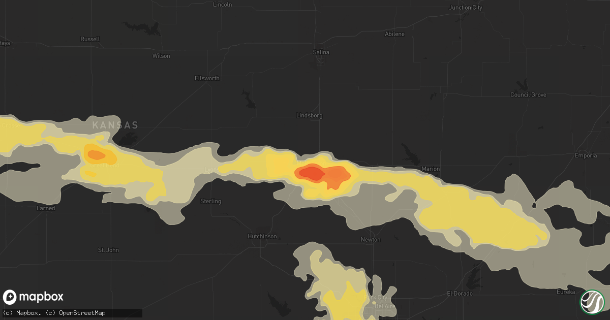
Hail Map in Mcpherson, KS on June 4, 2014
Get this storm
June 4 map
$229
one time, instant access
Download today. No call, no setup
Keep the $229
Bought the map and want the full workflow? Apply the entire $229 to a subscription within 7 days. None of it is wasted.
Every map, not just this one
This buys you this map. Subscription and you get every map we run, in the markets you choose from a few cities to whole states to nationwide. Plus real-time alerts the moment a storm fires.
Contact data
Name, contact info, occupancy, even credit band for addresses in the footprint. You go from where it hit to who to call.
Become the source they trust
Unlimited branding weather history reports on demand. You already have the documented answer ready for the property owner, and you are the one who showed up with it.
Property data and RoofTrace estimates
Pull up any address you have got, its value and the exact code rules for that jurisdiction, straight from One Click Code. Then RoofTrace estimates the squares, pitch, and roof value, priced the way you price.
Storm reports in Mcpherson, KS
Mcpherson, KS
| Date | Description |
|---|---|
| 06/04/20145:52 AM CDT | A local report indicates 64 MPH wind near MCPHERSON AIRPORT |
| 06/04/20145:50 AM CDT | Amateur radio reports damage to a garage door and tree at exit 60 of interstate 135. Time is estimated from radar. |
| 06/04/20144:55 AM CDT | Law enforcement estimating winds of 60 to 70 mph. |
| 06/04/20144:55 AM CDT | Trained spotter located in the 1700 block of limestone reporting 3.25 inch hail. Time is based on radar. |
| 06/04/20144:30 AM CDT | A local report indicates 2.00 inch wind near 7 WNW MCPHERSON |
All States Impacted by Hail Map on June 4, 2014
All Cities Impacted by Hail Map on June 4, 2014
- Gillette, WY
- Shell Knob, MO
- Lampe, MO
- Latham, KS
- Hugo, CO
- Genoa, CO
- Arriba, CO
- Agate, CO
- Deer Trail, CO
- Limon, CO
- Sheridan, WY
- Hopkinsville, KY
- Pembroke, KY
- Parker, CO
- Wallingford, KY
- Flemingsburg, KY
- Webbville, KY
- Louisa, KY
- Vale, SD
- Sturgis, SD
- Olpe, KS
- Hartford, KS
- Madison, KS
- Morganfield, KY
- Brush, CO
- Woodrow, CO
- Pierce City, MO
- Monett, MO
- Verona, MO
- Galena, MO
- Martin, TN
- Belle Fourche, SD
- Alliance, NE
- Hendersonville, TN
- Spearfish, SD
- Saint Onge, SD
- Le Roy, KS
- Bunker Hill, KS
- Booneville, KY
- Hays, KS
- Neosho Falls, KS
- Gridley, KS
- Summertown, TN
- Ethridge, TN
- Lawrenceburg, TN
- Pulaski, TN
- Ellsworth, NE
- Springfield, MO
- Nixa, MO
- Rogersville, MO
- Brookline, MO
- Ozark, MO
- Saint Mary, MO
- Madison, WV
- Dorrance, KS
- Bridger, MT
- Ponca City, OK
- Newkirk, OK
- Blackwell, OK
- Somerset, KY
- Eskdale, WV
- Dingess, WV
- Breeden, WV
- Chapmanville, WV
- Stollings, WV
- Logan, WV
- Amherstdale, WV
- Yolyn, WV
- Harts, WV
- Cyclone, WV
- Bridgeport, NE
- Ashby, NE
- Oshkosh, NE
- Lakeside, NE
- Bingham, NE
- Pikeville, KY
- Varney, KY
- Byers, CO
- Formoso, KS
- Eureka, KS
- Fulton, KY
- Water Valley, KY
- Otter, MT
- Aurora, MO
- La Crosse, KS
- Bison, KS
- Rush Center, KS
- Nekoma, KS
- Elkton, KY
- Trenton, KY
- Hammond, MT
- Alzada, MT
- Aurora, CO
- Berryville, AR
- Dighton, KS
- Weston, WY
- Gordon, NE
- Green Forest, AR
- Akron, CO
- Anton, CO
- Lindon, CO
- Albert, KS
- Medford, OK
- Burns, KS
- Hanston, KS
- Jetmore, KS
- Gays Creek, KY
- Chavies, KY
- Jackson, KY
- Buckhorn, KY
- Lesterville, MO
- Braman, OK
- Lexington, KY
- Nicholasville, KY
- Chandler, IN
- Evansville, IN
- Larned, KS
- Flagler, CO
- Benton, KY
- Brewster, KS
- Oakley, KS
- Monument, KS
- Colby, KS
- Levant, KS
- Murphysboro, IL
- Carbondale, IL
- Sarcoxie, MO
- Avilla, MO
- Jasper, MO
- Carthage, MO
- Reeds, MO
- La Russell, MO
- Hollister, MO
- Ridgedale, MO
- Irvington, KY
- Guston, KY
- Arthur, NE
- Hulett, WY
- Aladdin, WY
- Kyle, SD
- Manderson, SD
- Porcupine, SD
- Pine Ridge, SD
- Crane, MO
- Ullin, IL
- Pulaski, IL
- Fountain Run, KY
- Morgantown, KY
- Bowling Green, KY
- Rochester, KY
- Scottsville, KY
- Austin, KY
- Oakland, KY
- Voltaire, ND
- Velva, ND
- Utica, KS
- Rocklake, ND
- Hansboro, ND
- Belcourt, ND
- Saint John, ND
- Calvin, ND
- Sarles, ND
- Rolla, ND
- Clarksville, TN
- Adams, TN
- Derby, KS
- Decker, MT
- Ewing, KY
- Hickman, KY
- Union City, TN
- Seibert, CO
- Kiowa, CO
- Elizabeth, CO
- Rushville, NE
- Hay Springs, NE
- Scott City, KS
- Marienthal, KS
- Arapahoe, CO
- Cheyenne Wells, CO
- Kit Carson, CO
- Watkins, CO
- Strasburg, CO
- Bennett, CO
- Winona, MO
- Alton, MO
- Birch Tree, MO
- Fremont, MO
- Eminence, MO
- Cadiz, KY
- Sturgis, KY
- Providence, KY
- Shawneetown, IL
- Ridgway, IL
- Junction, IL
- Clay, KY
- Ekalaka, MT
- Equality, IL
- Eldorado, IL
- Omaha, IL
- Anna, IL
- Dongola, IL
- Jonesboro, IL
- Springfield, TN
- Clinton, KY
- Wadesville, IN
- Camp Crook, SD
- Capitol, MT
- Franklin, TN
- Sheridan Lake, CO
- Cassoday, KS
- Matfield Green, KS
- Cedar Point, KS
- Florence, KS
- Turtle Creek, WV
- Danville, WV
- Kinsley, KS
- Gallipolis, OH
- Crown City, OH
- Walnut Grove, MO
- Mcconnell Afb, KS
- Wichita, KS
- Lenzburg, IL
- Union Center, SD
- Mosquero, NM
- Nara Visa, NM
- Logan, NM
- Lehigh, KS
- Bazine, KS
- Cottonwood Falls, KS
- Little River, KS
- Lyons, KS
- Otis, KS
- Alexander, KS
- Galva, KS
- Peabody, KS
- Inman, KS
- Brownell, KS
- Raymond, KS
- Ness City, KS
- Marion, KS
- Chase, KS
- Hoisington, KS
- Windom, KS
- Hillsboro, KS
- Hudson, KS
- Alden, KS
- Mcpherson, KS
- Ellinwood, KS
- Great Bend, KS
- Olmitz, KS
- Moundridge, KS
- Canton, KS
- Moorcroft, WY
- Broadus, MT
- Franktown, CO
- Garden City, KS
- Lakin, KS
- Cope, CO
- Holcomb, KS
- Syracuse, KS
- Deerfield, KS
- Tribune, KS
- Kendall, KS
- Leoti, KS
- Vona, CO
- Mulvane, KS
- Belle Plaine, KS
- Healy, KS
- Crawford, NE
- Chrisney, IN
- Tennyson, IN
- Gentryville, IN
- West Liberty, KY
- Bentley, KS
- Sedgwick, KS
- Newell, SD
- Boyes, MT
- Garfield, KS
- Mohall, ND
- Max, ND
- Douglas, ND
- Minot, ND
- Seth, WV
- Pineville, KY
- Miracle, KY
- Nisland, SD
- Petersburg, TN
- Fayetteville, TN
- Bayard, NE
- Angora, NE
- Pinckneyville, IL
- Tamaroa, IL
- Manchester, OH
- Aberdeen, OH
- Ripley, OH
- Shelbyville, KY
- Blue Eye, MO
- Cassville, MO
- Oak Grove, AR
- Purdy, MO
- Gering, NE
- Minatare, NE
- Melbeta, NE
- Augusta, KS
- Waterloo, IL
- New Athens, IL
- Collyer, KS
- Owensboro, KY
- Reed, KY
- Mount Vernon, MO
- Piqua, KS
- Goddard, KS
- Clearwater, KS
- Chadron, NE
- Birney, MT
- Herndon, KY
- Strong City, KS
- Morehead, KY
- Clearfield, KY
- Lynnville, IN
- Oakland City, IN
- Elberfeld, IN
- Boonville, IN
- Metropolis, IL
- West Paducah, KY
- Paducah, KY
- Haysville, KS
- Peck, KS
- Enning, SD
- Mayfield, KS
- Wellington, KS
- Caldwell, KS
- Springerton, IL
- Enfield, IL
- Lincolnville, KS
- Beeler, KS
- Lewis, KS
- Cimarron, KS
- Spearville, KS
- Eddyville, KY
- Kuttawa, KY
- Bardwell, KY
- Arlington, KY
- Charleston, MO
- Columbus, KY
- East Prairie, MO
- Salt Lick, KY
- Wellington, KY
- Greenbrier, TN
- Burlington, ND
- Des Lacs, ND
- Crofton, KY
- Conway Springs, KS
- Hurricane Mills, TN
- Waverly, TN
- Newton, KS
- Pawnee Rock, KS
- Walton, KS
- Ellington, MO
- Quinter, KS
- Salina, KS
- Winona, KS
- Dahlgren, IL
- Belle Rive, IL
- Lodge Grass, MT
- Williamsport, TN
- Mount Pleasant, TN
- Duck River, TN
- Hampshire, TN
- Lewisburg, TN
- Belfast, TN
- Murray, KY
- Richmond, KY
- Golden City, MO
- Lockwood, MO
- Miller, MO
- Hoxie, KS
- Matheson, CO
- Simla, CO
- South Fulton, TN
- Eads, CO
- Goodlettsville, TN
- Oxford, KS
- Gove, KS
- Grinnell, KS
- Earlington, KY
- Madisonville, KY
- Harrisburg, NE
- Kimball, NE
- Brookville, KS
- Rives, TN
- Troy, TN
- Rapid City, SD
- Keystone, SD
- Hill City, SD
- Princeton, KY
- Dawson Springs, KY
- Waldo, KS
- Luray, KS
- Colwich, KS
- Raleigh, IL
- McKenzie, TN
- Bradford, TN
- Rutherford, TN
- Greenfield, TN
- Gordon, WV
- Hewett, WV
- Spurlockville, WV
- Big Creek, WV
- Jeffrey, WV
- Douglass, KS
- Rose Hill, KS
- Harrison, NE
- Pittsburg, KS
- Mindenmines, MO
- Huntingdon, TN
- Fort Lupton, CO
- Lynnville, TN
- Fredericktown, MO
- Udall, KS
- Winfield, KS
- Sawyer, ND
- Andover, KS
- Bonnie, IL
- Opdyke, IL
- South Haven, KS
- Bear Branch, KY
- Fort Gay, WV
- Olive Hill, KY
- Hillsboro, KY
- Owingsville, KY
- Oral, SD
- Waltonville, IL
- Mount Vernon, IL
- Fancy Farm, KY
- Anniston, MO
- Ona, WV
- Sainte Genevieve, MO
- Dunseith, ND
- Hutchinson, KS
- Valley Center, KS
- Broughton, IL
- Burrton, KS
- Hohenwald, TN
- Whitewood, SD
- Centerville, TN
- Hot Springs, SD
- Edgemont, SD
- Kevil, KY
- Karnak, IL
- Grand Chain, IL
- Brookport, IL
- Beverly, KS
- Douglas, WY
- Columbia, TN
- Culleoka, TN
- Stratton, CO
- Henry, TN
- Bruceton, TN
- Mansfield, TN
- Hollow Rock, TN
- Ellsinore, MO
- Hazel, KY
- Buchanan, TN
- New Concord, KY
- Viola, KS
- Kechi, KS
- Garden Plain, KS
- Maize, KS
- Rock, KS
- Andale, KS
- Argonia, KS
- Leon, KS
- Atlanta, KS
- Haven, KS
- Halstead, KS
- Milan, KS
- Cambridge, KS
- Mount Hope, KS
- Geuda Springs, KS
- Burden, KS
- Arkansas City, KS
- Sandy Hook, KY
- Guthrie, KY
- Greenfield, MO
- Dadeville, MO
- Leoma, TN
- Frankfort, KY
- Waddy, KY
- Bagdad, KY
- South Webster, OH
- Wheelersburg, OH
- Beattyville, KY
- Irvine, KY
- Dresden, TN
- Gleason, TN
- Saco, MT
- Ellis, KS
- Lance Creek, WY
- Rozel, KS
- Morristown, SD
- St John, KS
- Festus, MO
- De Soto, MO
- McLeansboro, IL
- Moorefield, KY
- Carlisle, KY
- Everton, MO
- McEwen, TN
- Woodlawn, TN
- Ogallah, KS
- Ironton, MO
- Park, KS
- Nunnelly, TN
- Burlington, CO
- Wyola, MT
- Palmyra, TN
- Arcadia, MO
- Jadwin, MO
- Salem, MO
- Glenburn, ND
- Manville, WY
- Sedalia, CO
- Watauga, SD
- Milton, WV
- Lesage, WV
- Thompsons Station, TN
- Elmdale, KS
- Clearmont, WY
- Wayne, WV
- Lavalette, WV
- Towanda, KS
- El Dorado, KS
- Griffithsville, WV
- Alkol, WV
- Sumerco, WV
- Julian, WV
- Yawkey, WV
- Carmi, IL
- White Owl, SD
- New England, ND
- Toronto, KS
- South Portsmouth, KY
- West Portsmouth, OH
- South Shore, KY
- Vanleer, TN
- Charlotte, TN
- Dickson, TN
- Goodland, KS
- Orgas, WV
- Comfort, WV
- Norwich, ND
- Patton, MO
- Marquand, MO
- Fargo, OK
- Melber, KY
- Martin, KY
- Allen, KY
- Prestonsburg, KY
- Lincoln, KS
- Wounded Knee, SD
- Flintville, TN
- Du Bois, IL
- Ashley, IL
- Aldrich, MO
- Franklin, KY
- Perryville, MO
- West Frankfort, IL
- Puryear, TN
- Mayfield, KY
- Sedalia, KY
- Lucas, KS
- Boaz, KY
- Gorham, KS
- Russell, KS
- Goreville, IL
- Makanda, IL
- Henderson, KY
- Corydon, KY
- East Point, KY
- Oil Springs, KY
- Hagerhill, KY
- Elizabethtown, KY
- Morland, KS
- Sharon Springs, KS
- Ash Grove, MO
- Victoria, KS
- Stout, OH
- Blue Creek, OH
- Springville, TN
- Paris, TN
- Buhler, KS
- Meriden, WY
- Cheyenne, WY
- De Soto, IL
- Pine Bluffs, WY
- Albin, WY
- Fort Campbell, KY
- Chapmansboro, TN
- Arcola, MO
- Sylvan Grove, KS
- Calvert City, KY
- Tolley, ND
- White Plains, KY
- Buffalo, SD
- Lost Springs, KS
- Philpot, KY
- Sharon, TN
- Raymondville, MO
- Junction City, KS
- Cypress, IL
- Arnold, KS
- Salyersville, KY
- De Mossville, KY
- Falmouth, KY
- Cape Fair, MO
- Kimberling City, MO
- Freistatt, MO
- Alpena, AR
- Marionville, MO
- Stotts City, MO
- Branson, MO
- Wentworth, MO
- Reeds Spring, MO
- Salem, KY
- Marion, KY
- New Johnsonville, TN
- Emporia, KS
- Council Grove, KS
- Bucyrus, MO
- Success, MO
- Cornersville, TN
- Dellrose, TN
- Frankewing, TN
- Cottage Grove, TN
- Allensville, KY
- Oak Grove, KY
- Cerulean, KY
- Olmstead, KY
- Gracey, KY
- Boss, MO
- Trezevant, TN
- Summersville, MO
- Yeaddiss, KY
- Big Laurel, KY
- Ellsworth, KS
- Wingo, KY
- Bethune, CO
- Lobelville, TN
- Quincy, KY
- Kenton, TN
- Nardin, OK
- Shields, ND
- Carson, ND
- Selfridge, ND
- West Union, OH
- Winchester, OH
- Russellville, OH
- Frenchburg, KY
- Alto Pass, IL
- Cobden, IL
- Couch, MO
- Allen, SD
- Sundance, WY
- Hickory, KY
- Wickliffe, KY
- Barlow, KY
- Cunningham, KY
- La Center, KY
- Olaton, KY
- Hartford, KY
- Wallace, KS
- Buena Vista, TN
- Westport, TN
- Bloomsdale, MO
- Ransom, KS
- Paradise, KS
- Piedmont, KS
- Westmoreland, TN
- Fort Branch, IN
- Grandview, IN
- Francisco, IN
- Princeton, IN
- Dale, IL
- Macedonia, IL
- Patriot, OH
- Gallipolis Ferry, WV
- Apple Grove, WV
- Yoder, WY
- Hawk Springs, WY
- Only, TN
- Waco, KY
- Clay Center, KS
- Golconda, IL
- Ozark, IL
- Simpson, IL
- Eddyville, IL
- Neal, KS
- Severy, KS
- Colony, KS
- Whitewater, KS
- Virgil, KS
- Goessel, KS
- Potwin, KS
- Sylvia, KS
- Hesston, KS
- Hamilton, KS
- Sterling, KS
- Yates Center, KS
- Ridgeview, WV
- Nellis, WV
- Racine, WV
- Foster, WV
- Peytona, WV
- Costa, WV
- Farmington, KY
- Kirksey, KY
- Santa Fe, TN
- Cunningham, TN
- Cumberland Furnace, TN
- Beloit, KS
- White House, TN
- Wakeeney, KS
- Benton, KS
- Thompsonville, IL
- Mud Butte, SD
- Ricetown, KY
- Perth, ND
- Sutherland, NE
- Kanopolis, KS
- Hernshaw, WV
- Tescott, KS
- Palmersville, TN
- Dukedom, TN
- Fredonia, KY
- Fort Morgan, CO
- Vincent, KY
- Newburgh, IN
- Doniphan, MO
- Maynard, AR
- Genoa, WV
- Scottown, OH
- Chesapeake, OH
- Proctorville, OH
- Woodlawn, IL
- Livermore, KY
- Calhoun, KY
- Portland, TN
- Bethpage, TN
- Grainfield, KS
- Millersville, MO
- Marble Hill, MO
- Lansford, ND
- Licking, MO
- Isonville, KY
- Whitney, NE
- Hampton, KY
- Bois D Arc, MO
- Hazard, KY
- Burna, KY
- Lyles, TN
- Cottontown, TN
- Iola, KS
- Castle Rock, CO
- Opolis, KS
- Asbury, MO
- Verona, KY
- Butler, KY
- Crittenden, KY
- West Plains, MO
- Eva, TN
- Camden, TN
- Big Sandy, TN
- Raywick, KY
- Viper, KY
- Willard, MO
- Weskan, KS
- Grand Rivers, KY
- Smithland, KY
- Harrisburg, IL
- Galatia, IL
- Mound City, IL
- Tamms, IL
- Mounds, IL
- Thebes, IL
- Olive Branch, IL
- Cairo, IL
- Oceana, WV
- Penokee, KS
- Van Buren, MO
- Monroe, NY
- Washingtonville, NY
- Craryville, NY
- Hudson, NY


