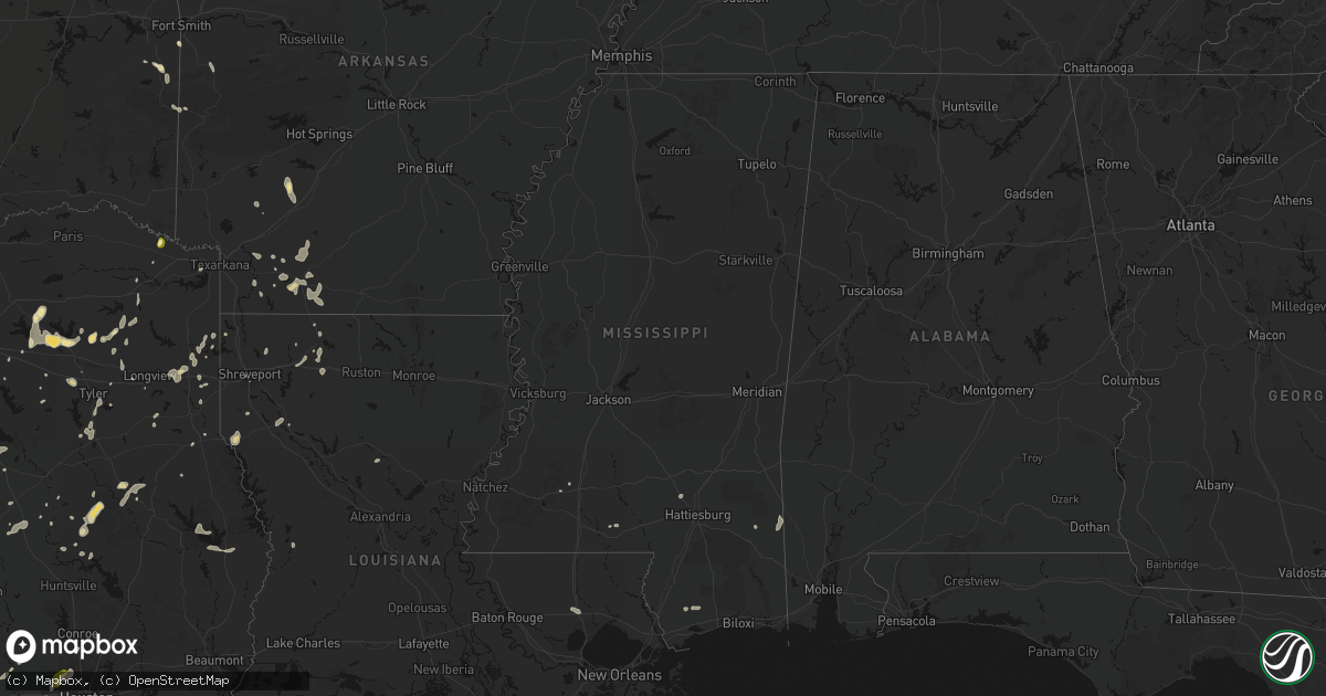
Hail Map in Mississippi on June 2, 2026
Get this storm
June 2 map
$229
one time, instant access
Download today. No call, no setup
Keep the $229
Bought the map and want the full workflow? Apply the entire $229 to a subscription within 7 days. None of it is wasted.
Every map, not just this one
This buys you this map. Subscription and you get every map we run, in the markets you choose from a few cities to whole states to nationwide. Plus real-time alerts the moment a storm fires.
Contact data
Name, contact info, occupancy, even credit band for addresses in the footprint. You go from where it hit to who to call.
Become the source they trust
Unlimited branding weather history reports on demand. You already have the documented answer ready for the property owner, and you are the one who showed up with it.
Property data and RoofTrace estimates
Pull up any address you have got, its value and the exact code rules for that jurisdiction, straight from One Click Code. Then RoofTrace estimates the squares, pitch, and roof value, priced the way you price.
Storm reports in Mississippi
Mississippi
| Date | Description |
|---|---|
| 06/02/20266:14 PM CDT | Tree downed on jasper county near hwy 15 and county rd 1553. |
| 06/02/20266:09 PM CDT | Law enforcement reported couple of trees down on dry grove in hinds county. |
| 06/02/20266:06 PM CDT | Law enforcement reported couple of trees down on neil collins rd in hinds county. |
| 06/02/20265:40 PM CDT | Tree downed near the intersection of mullican rd and hickory ridge rd. |
| 06/02/20265:35 PM CDT | Tree downed near the 180 block of hayes place. |
| 06/02/20265:35 PM CDT | Tree downed on smith county rd 106. |
| 06/02/20265:31 PM CDT | Tree downed on smith county rd 114. |
| 06/02/20265:23 PM CDT | Trees downed on smith county rd 77 and county rd 121. |
| 06/02/20265:17 PM CDT | Tree downed on smith county rd 540/2. |
| 06/02/20265:15 PM CDT | Tree downed on jasper county near hwy 15 and county rd 1553. |
| 06/02/20265:12 PM CDT | Tree downed on jasper county near hwy 15 and county rd 20. |
All States Impacted by Hail Map on June 2, 2026
Cities Impacted by Hail Map on June 2, 2026
- Bunch, OK
- Rolla, KS
- Chester, AR
- Natural Dam, AR
- Pocola, OK
- Fort Smith, AR
- Stilwell, OK
- Mountainburg, AR
- Goodwell, OK
- Booneville, AR
- Mansfield, AR
- Waldron, AR
- Heavener, OK
- Poteau, OK
- Mena, AR
- Shady Point, OK
- Sanborn, ND
- Rogers, ND
- Howe, OK
- Guymon, OK
- Hooker, OK
- Cooperstown, ND
- Aneta, ND
- Edmore, ND
- Conchas Dam, NM
- Milton, ND
- Osnabrock, ND
- Fairdale, ND
- Mescalero, NM
- Santa Rosa, NM
- McGregor, TX
- Richwood, WV
- Langdon, ND
- De Kalb, TX
- Cavalier, ND
- Walhalla, ND
- Mountain, ND
- Magnolia, AR
- Mosquero, NM
- Willow City, ND
- Oglesby, TX
- Mineral Springs, AR
- Moody, TX
- McCaskill, AR
- Emerson, AR
- Newkirk, NM
- Rolette, ND
- Hebron, NE
- Dunseith, ND
- Carleton, NE
- Athens, TX
- Okolona, AR
- Blevins, AR
- Reva, SD
- Tyler, TX
- Homer, LA
- Gatesville, TX
- Neche, ND
- Belcourt, ND
- Texarkana, TX
- Rugby, ND
- De Berry, TX
- Fort Hood, TX
- Waldo, AR
- Saint John, ND
- Belle Fourche, SD
- Whitehouse, TX
- Souris, ND
- Garita, NM
- Athens, LA
- Hope, AR
- Fairmont, NE
- Marshall, TX
- Minden, LA
- Haynesville, LA
- Troup, TX
- Overton, TX
- Hallsville, TX
- Newell, SD
- Rolla, ND
- Bottineau, ND
- Garland City, AR
- Gibsland, LA
- Lindale, TX
- Cookville, TX
- Mount Pleasant, TX
- Buffalo, SD
- Grafton, NE
- Jonesboro, TX
- Taylor, AR
- Nara Visa, NM
- Omaha, TX
- Pittsburg, TX
- Rosston, AR
- Jacksonville, TX
- Mayhill, NM
- Arcadia, LA
- West Palm Beach, FL
- Stamps, AR
- Benton, LA
- Max, ND
- Sibley, LA
- Bullard, TX
- Lewisville, AR
- Garrison, ND
- Buckner, AR
- Mount Calm, TX
- Hubbard, TX
- Coolidge, TX
- Canton, TX
- Vaughn, NM
- Mart, TX
- Riesel, TX
- Waco, TX
- Perth, ND
- Cloudcroft, NM
- Ben Wheeler, TX
- La Luz, NM
- Cranfills Gap, TX
- Meridian, TX
- Minot, ND
- Oelrichs, SD
- Rocklake, ND
- Hansboro, ND
- Bisbee, ND
- Sawyer, ND
- Mcclusky, ND
- Stephens, AR
- Kadoka, SD
- Pine Ridge, SD
- Jefferson, TX
- Henderson, TX
- Shreveport, LA
- Kemp, TX
- Winnsboro, TX
- Como, TX
- Quitman, TX
- Axtell, TX
- Gilmer, TX
- Norwich, ND
- Fort Davis, TX
- Interior, SD
- Butte, ND
- Vivian, LA
- Oglala, SD
- Surrey, ND
- Iredell, TX
- Scurry, TX
- Bent, NM
- Point, TX
- Lone Oak, TX
- Hannah, ND
- McNeil, AR
- Kyle, SD
- Kaufman, TX
- Wills Point, TX
- Joaquin, TX
- Tenaha, TX
- Gloster, LA
- Mercer, ND
- Drake, ND
- Philip, SD
- Karnack, TX
- Mineola, TX
- Nevada, TX
- Conroe, TX
- Ennis, TX
- Tularosa, NM
- Emory, TX
- Palm Beach Gardens, FL
- Big Sandy, TX
- Deering, ND
- Timpson, TX
- Sarles, ND
- Lavon, TX
- Alba, TX
- Cumby, TX
- Logansport, LA
- Grand Cane, LA
- Houston, TX
- Coushatta, LA
- Gladewater, TX
- Stephenville, TX
- Edgewood, TX
- Granville, ND
- Kiln, MS
- Dawson, TX
- Weed, NM
- Egeland, ND
- Corsicana, TX
- Fairfield, TX
- Streetman, TX
- Rosser, TX
- Cleburne, TX
- Spring, TX
- Calvin, ND
- Adrian, TX
- Bluff Dale, TX
- Daytona Beach, FL
- Anamoose, ND
- Wanblee, SD
- Mansfield, LA
- Barry, TX
- Leakesville, MS
- Neely, MS
- Devils Lake, ND
- Manderson, SD
- State Line, MS
- Fruitdale, AL
- Center, TX
- Pass Christian, MS
- Saucier, MS
- Gulfport, MS
- Alamogordo, NM
- Munich, ND
- Channing, TX
- Crandall, TX
- Seagoville, TX
- Tylertown, MS
- Van Horn, TX
- Holloman Air Force Base, NM
- Alto, TX
- Webster, ND
- Port Orange, FL
- Ferris, TX
- Porcupine, SD
- Cypress, TX
- Nacogdoches, TX
- Terrell, TX
- Forney, TX
- Lance Creek, WY
- Flagler Beach, FL
- Palm Coast, FL
- Purdon, TX
- Tolar, TX
- Douglass, TX
- Waller, TX
- Hockley, TX
- Saint Stephens, AL
- Leroy, AL
- New Smyrna Beach, FL
- Italy, TX
- Kilgore, TX
- Prairie View, TX
- Hempstead, TX
- Starkweather, ND
- Katy, TX
- Tolna, ND
- Warwick, ND
- Zolfo Springs, FL
- Ormond Beach, FL
- Brookhaven, MS
- Pinon, NM
- Miami, FL
- Kennard, TX
- Crockett, TX
- Irving, TX
- Grapeland, TX
- Sierra Blanca, TX
- Edgewater, FL
- Blooming Grove, TX
- Hope, NM
- Maddock, ND
- Allen, SD
- Hartley, TX
- Dalhart, TX
- Midlothian, TX
- Oak Hill, FL
- Osteen, FL
- Mesquite, TX
- Dallas, TX
- Buffalo, TX
- Crary, ND
- San Jon, NM
- Bard, NM
- Mansfield, TX
- Arlington, TX
- Bellville, TX
- Venus, TX
- Centerville, TX
- Grand Prairie, TX
- Lakota, ND
- Wells, TX
- Hammond, LA
- Valentine, TX
- Lawton, ND
- Buffalo Gap, SD
- Chacon, NM
- Mora, NM
- Esmond, ND
- Lovelady, TX
- Burleson, TX
- Pollok, TX
- Georgetown, LA
- Alvarado, TX
- Alsen, ND
- Douglas, WY
- Jasper, TX
- Richmond, TX
- Logan, NM
- Fulshear, TX
- Brookshire, TX
- Coppell, TX
- Hoven, SD
- Java, SD
- Harvey, ND
- Grapevine, TX
- Euless, TX
- White River, SD
- Selby, SD
- Broaddus, TX
- Lorida, FL
- Brocket, ND
- Bedford, TX
- Wales, ND
- Truth Or Consequences, NM
- Carrizozo, NM
- Grandview, TX
- Jewett, TX
- Plano, TX
- Fort Sumner, NM
- Fort Worth, TX
- Steele, ND
- Trinity, TX
- Hurst, TX
- Colleyville, TX
- Rosenberg, TX
- Fairburn, SD
- Oakwood, TX
- Marquez, TX
- Okeechobee, FL
- Hurdsfield, ND
- Chaseley, ND
- Sealy, TX
- Wallis, TX
- Cimarron, NM
- Chamisal, NM
- Bowdle, SD
- Normangee, TX
- Carrollton, TX
- Robinson, ND
- Dawson, ND
- Aledo, TX
- Adams, ND
- Hot Springs, SD
- Edgemont, SD
- Linton, ND
- Oral, SD
- Martin, SD
- Kintyre, ND
- Haltom City, TX
- Hampden, ND
- Hensel, ND
- Caldwell, TX
- Leesville, LA
- Cuervo, NM
- Frisco, TX
- Weatherford, TX
- The Colony, TX
- Eureka, SD
- Tappen, ND
- Dime Box, TX
- Napoleon, ND
- Balch Springs, TX
- Herreid, SD
- Upton, WY
- Godley, TX
- Cresson, TX
- Gause, TX
- Pettibone, ND
- Leander, TX
- Sundance, WY
- McLaughlin, SD
- Lexington, TX
- Tuthill, SD
- Schulenburg, TX
- Azle, TX
- Moorcroft, WY
- Selfridge, ND
- Murdo, SD
- Granbury, TX
- Dell City, TX
- Custer, SD
- Clewiston, FL
- Weimar, TX
- Lipan, TX
- Moore Haven, FL
- Draper, SD
- Rockdale, TX
- Cameron, TX
- Bathgate, ND
- Woodworth, ND
- Lehr, ND
- Milano, TX
- Gackle, ND
- Paige, TX
- Devils Tower, WY
- Hamilton, ND
- Fredonia, ND
- Hearne, TX
- Wood, SD
- Streeter, ND
- Seminary, MS
- Alva, WY
- Hammond, MT
- Lead, SD
- Hulett, WY
- Austin, TX
- Gillette, WY
- Mission, SD
- Vivian, SD
- Thrall, TX
- Thorndale, TX
- Del Valle, TX
- Presho, SD
- Okreek, SD
- Ekalaka, MT
- Michigan, ND
- Spearfish, SD
- Chadron, NE
- Cleveland, ND
- Medina, ND
- Edinburg, ND
- Harwood, TX
- Luling, TX
- Breckenridge, TX
- Coleman, TX
- Santa Anna, TX
- Brady, TX
- Buchanan, ND
- El Paso, TX
- Buda, TX
- Montpelier, ND
- Johnson City, TX
- Lankin, ND
- Kensal, ND
- Courtenay, ND
- Kyle, TX
- Hoople, ND
- Gonzales, TX
- Pingree, ND
- Park River, ND
- Glenfield, ND
- Voca, TX
- Jamestown, ND
- Alzada, MT
- Boyes, MT
- Nixon, TX
- Fort Bliss, TX
- Wimberley, TX
- Tuttle, ND
- Blanco, TX
- Dripping Springs, TX
- Hannaford, ND
- Sutton, ND
- Binford, ND
- Spiritwood, ND
- Fordville, ND
- Mason, TX
- Tahlequah, OK
- Seguin, TX
- Petersburg, ND
- Broken Arrow, OK
- Tulsa, OK
- Wimbledon, ND
- San Marcos, TX
- Baker, MT
- Martindale, TX
- Maxwell, TX
- Melrose, NM
- Mcville, ND
- Wounded Knee, SD
- Dazey, ND
- Roswell, NM
- Smiley, TX
- Hay Springs, NE
- Stockdale, TX
- Whitney, NE
- Dahlen, ND
- Finley, ND
- Jessie, ND
- Sharon, ND
- Niagara, ND
- Gillett, TX
- Rushville, NE
- Menard, TX
- Hext, TX
- Saint Francis, SD
- Batesland, SD
- Roscoe, TX
- Rhame, ND
- Fort Pierre, SD
- Maryneal, TX
- Norris, SD
- Mandan, ND
- Harrold, SD
- Amidon, ND
- Bowman, ND
- Lower Brule, SD
- Bismarck, ND
- Kennebec, SD
- Pierre, SD
- Post, TX
- Reliance, SD
- Snyder, TX
- Hermleigh, TX
- Highmore, SD
- Holabird, SD
- Ira, TX
- Tahoka, TX
- Parmelee, SD
- Wilson, TX
- Muskogee, OK
- Fluvanna, TX
- Hermosa, SD
- Gordon, NE
- Gail, TX
- Clovis, NM
- Larimore, ND
- Merriman, NE
- Odonnell, TX
- Cody, NE
- Nenzel, NE
- Kilgore, NE
- Ackerly, TX
- Fessenden, ND
- Kress, TX
- Wood Lake, NE
- Springview, NE
- Silverton, TX
- Howes, SD
- Hialeah, FL
- Dexter, NM
- Hagerman, NM
- Artesia, NM
- Lake Arthur, NM
- Loving, NM
- Carlsbad, NM
- Taiban, NM
- Stratford, TX
- Zeeland, ND
- Ashley, ND


