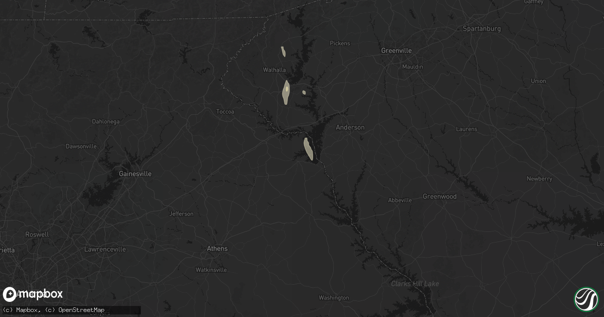
Hail Map in Hartwell, GA on June 1, 2026
Get this storm
June 1 map
$229
one time, instant access
Download today. No call, no setup
Keep the $229
Bought the map and want the full workflow? Apply the entire $229 to a subscription within 7 days. None of it is wasted.
Every map, not just this one
This buys you this map. Subscription and you get every map we run, in the markets you choose from a few cities to whole states to nationwide. Plus real-time alerts the moment a storm fires.
Contact data
Name, contact info, occupancy, even credit band for addresses in the footprint. You go from where it hit to who to call.
Become the source they trust
Unlimited branding weather history reports on demand. You already have the documented answer ready for the property owner, and you are the one who showed up with it.
Property data and RoofTrace estimates
Pull up any address you have got, its value and the exact code rules for that jurisdiction, straight from One Click Code. Then RoofTrace estimates the squares, pitch, and roof value, priced the way you price.
Storm reports in Hartwell, GA
Hartwell, GA
| Date | Description |
|---|---|
| 06/01/20263:16 PM CDT | Firefighter reported trees and powerlines down on montevideo road. |
| 06/01/20263:15 PM CDT | County official reported roof of a church was blown off. |
| 06/01/20263:07 PM CDT | Tree down in 4300 block of cokesbury hwy. |
| 06/01/20263:04 PM CDT | Firefighter reported trees down on anderson highway. |
| 06/01/20263:04 PM CDT | Firefighter reported trees and powerlines down on milford road. |
| 06/01/20263:00 PM CDT | Firefighter reported trees down on old 29 highway. |
| 06/01/20262:55 PM CDT | A severe thunderstorm produced a swath of 60-75 mph wind extending from just east of hartwell to far northeast elbert county. The damaging wind swath began near hart st |
| 06/01/20262:47 PM CDT | Numerous social media reports of downed and uprooted trees in reed creek. Time estimated from radar. |
All States Impacted by Hail Map on June 1, 2026
All Cities Impacted by Hail Map on June 1, 2026
- Sainte Genevieve, MO
- Calvert City, KY
- Burlington, CO
- Farmington, MO
- Saint Mary, MO
- Vergennes, IL
- Du Quoin, IL
- Gilbertsville, KY
- Benton, KY
- Idalia, CO
- Gorham, IL
- Murphysboro, IL
- Ava, IL
- Memphis, TN
- Kirksey, KY
- Mayfield, KY
- Dover, TN
- Symsonia, KY
- Utica, KS
- Ullin, IL
- Dongola, IL
- Kanorado, KS
- Smithland, KY
- Goodland, KS
- Grand Rivers, KY
- Marble Hill, MO
- Karnak, IL
- Grand Chain, IL
- Cypress, IL
- Hardin, KY
- Almo, KY
- Cobden, IL
- Anna, IL
- Olmsted, IL
- Vienna, IL
- Belknap, IL
- Dexter, KY
- La Center, KY
- Barlow, KY
- Metropolis, IL
- Mound City, IL
- Kevil, KY
- Wickliffe, KY
- Clinton, KY
- East Prairie, MO
- Charleston, MO
- Columbus, KY
- Bardwell, KY
- Cunningham, KY
- Arlington, KY
- Fancy Farm, KY
- Wingo, KY
- Hickory, KY
- Boaz, KY
- Farmington, KY
- Fulton, KY
- Sedalia, KY
- Union City, TN
- McKenzie, TN
- Gleason, TN
- Mount Pleasant, TN
- Columbia, TN
- Culleoka, TN
- Lynnville, TN
- Sherburn, MN
- Welcome, MN
- Lewisburg, TN
- Belfast, TN
- Cornersville, TN
- Petersburg, TN
- Pulaski, TN
- Ceylon, MN
- Fairmont, MN
- Decaturville, TN
- Waynesboro, TN
- Clifton, TN
- Dolliver, IA
- Linden, TN
- Armstrong, IA
- Corinth, MS
- Fayetteville, TN
- Ripley, MS
- Burnsville, MS
- Glen, MS
- Iuka, MS
- Ringsted, IA
- Kelso, TN
- Flintville, TN
- Mulberry, TN
- Frankewing, TN
- Ardmore, TN
- Dellrose, TN
- Prospect, TN
- Booneville, MS
- Rienzi, MS
- Belvidere, TN
- Huntland, TN
- Elora, TN
- Baldwyn, MS
- Goodspring, TN
- Minor Hill, TN
- Tishomingo, MS
- Taft, TN
- Savannah, TN
- Estillfork, AL
- Marietta, MS
- Ardmore, AL
- Killen, AL
- Florence, AL
- Elkmont, AL
- New Site, MS
- Dennis, MS
- Belmont, MS
- Blue Mountain, MS
- Guntown, MS
- Mantachie, MS
- Athens, AL
- Dumas, MS
- Gurley, AL
- Toney, AL
- Huntsville, AL
- Meridianville, AL
- Chalmette, LA
- Saltillo, MS
- Harvest, AL
- Madison, AL
- Amory, MS
- Golden, MS
- Red Bay, AL
- Paint Rock, AL
- Woodville, AL
- Scottsboro, AL
- Trinity, AL
- Moulton, AL
- Aberdeen, MS
- Russellville, AL
- Brownsboro, AL
- Fulton, MS
- Tremont, MS
- Decatur, AL
- Grant, AL
- Smithville, MS
- Hartselle, AL
- Houston, AL
- Somerville, AL
- Nettleton, MS
- Danville, AL
- Hamilton, AL
- Mount Hope, AL
- Greenwood Springs, MS
- Langston, AL
- Guntersville, AL
- Detroit, AL
- Logan, AL
- Cullman, AL
- Vinemont, AL
- Addison, AL
- Tupelo, MS
- Hamilton, MS
- Nauvoo, AL
- Beaverton, AL
- Falkville, AL
- Shannon, MS
- Union Grove, AL
- Arab, AL
- Vanzant, MO
- Albertville, AL
- Groveoak, AL
- Crane Hill, AL
- Arley, AL
- Caledonia, MS
- Haleyville, AL
- Winfield, AL
- Brilliant, AL
- Carbon Hill, AL
- Crossville, AL
- Colorado Springs, CO
- Hanceville, AL
- Lynn, AL
- Jasper, AL
- Double Springs, AL
- Altoona, AL
- Boaz, AL
- Geraldine, AL
- Denver, CO
- Blountsville, AL
- Fayette, AL
- Columbus, MS
- Vernon, AL
- Sulligent, AL
- Seneca, SC
- Walhalla, SC
- Eldridge, AL
- Oneonta, AL
- Horton, AL
- Bremen, AL
- Larkspur, CO
- Franktown, CO
- Gallant, AL
- Attalla, AL
- Steele, AL
- Cordova, AL
- Oldfield, MO
- Garrison, MO
- Millport, AL
- Parrish, AL
- Gadsden, AL
- West Plains, MO
- Berry, AL
- Oakman, AL
- Townley, AL
- Steens, MS
- Bankston, AL
- Rainbow City, AL
- Aurora, CO
- Commerce City, CO
- Dora, MO
- Wheatland, WY
- Drury, MO
- Littleton, CO
- Ethelsville, AL
- Northport, AL
- Quinton, AL
- Ashville, AL
- Bradleyville, MO
- Reform, AL
- Collinsville, AL
- Guernsey, WY
- Englewood, CO
- Wellington, AL
- Ohatchee, AL
- Fort Davis, TX
- Peyton, CO
- Brooksville, MS
- Lone Tree, CO
- Norwood, MO
- Caulfield, MO
- Pottersville, MO
- Elbert, CO
- Springfield, CO
- Talladega, AL
- Lincoln, AL
- Taneyville, MO
- Fort Laramie, WY
- Yoder, WY
- Lingle, WY
- Hartwell, GA
- Jacksonville, AL
- Alexandria, AL
- Weaver, AL
- Veteran, WY
- Torrington, WY
- Cedarcreek, MO
- Columbiana, AL
- Chelsea, AL
- Ava, MO
- Alpine, AL
- Heflin, AL
- Macon, MS
- Anniston, AL
- Watkins, CO
- Bennett, CO
- Moody, MO
- Aliceville, AL
- Wilsonville, AL
- Sylacauga, AL
- Menlo, IA
- Stuart, IA
- Goodwater, AL
- Centreville, AL
- Squires, MO
- Rueter, MO
- Mammoth Spring, AR
- Rockford, AL
- Alpine, TX
- Lodge Grass, MT
- Childersburg, AL
- Randolph, AL
- Lead Hill, AR
- Brixey, MO
- Strasburg, CO
- Scott City, KS
- Fort Morgan, CO
- Kellyton, AL
- West Blocton, AL
- Weogufka, AL
- Ackerman, MS
- Woodland, AL
- Roanoke, AL
- Boligee, AL
- Hardy, AR
- Deer Trail, CO
- Byers, CO
- Gainesville, MO
- Parker, CO
- Oil Trough, AR
- Healy, KS
- Woodrow, CO
- Edgemont, SD
- Louisville, MS
- Brookhaven, MS
- Billings, MT
- Williford, AR
- Five Points, AL
- Lamar, CO
- Harrison, AR
- Wesson, MS
- Lagrange, GA
- Montgomery, AL
- Ash Flat, AR
- Wiggins, CO
- Dighton, KS
- Woodland Park, CO
- Garryowen, MT
- Gallion, AL
- Forkland, AL
- West Point, GA
- Livingston, AL
- Alexander City, AL
- Ramer, AL
- Cherokee Village, AR
- Wellington, CO
- Laporte, CO
- Fort Collins, CO
- Carr, CO
- Cheyenne, WY
- Harrison, NE
- Morrill, NE
- Lance Creek, WY
- Big Flat, AR
- Harriet, AR
- Jefferson, IA
- Newark, AR
- Flippin, AR
- Lindon, CO
- Akron, CO
- Paton, IA
- Churdan, IA
- Pine Mountain, GA
- Panora, IA
- Clarendon, TX
- Claude, TX
- Kit Carson, CO
- Yellville, AR
- Everton, AR
- Saint Joe, AR
- De Kalb, MS
- Ruth, MS
- Tallulah, LA
- Onia, AR
- Marshall, AR
- Timbo, AR
- Philadelphia, MS
- Evening Shade, AR
- Newport, AR
- Holly, CO
- Granada, CO
- Noxapater, MS
- Dana, IA
- Horseshoe Bend, AR
- Valley Springs, AR
- Hattiesburg, MS
- Batesville, AR
- Bogue Chitto, MS
- Winona, KS
- Kendall, KS
- Chugwater, WY
- Saint Francis, KS
- Monument, CO
- Elizabeth, CO
- Gainestown, AL
- Byhalia, MS
- Sumrall, MS
- Cheyenne Wells, CO
- Sulphur Rock, AR
- Simla, CO
- Bethune, CO
- Tuckerman, AR
- Leslie, AR
- McCrory, AR
- Jamaica, IA
- Walnut Ridge, AR
- Madison, MS
- Ward, AL
- Pennington, AL
- Butler, AL
- Gilbert, AR
- Wallace, KS
- Fox, AR
- Walsh, CO
- Hurtsboro, AL
- Stinnett, TX
- Palmer Lake, CO
- Rosie, AR
- Midland, GA
- Busby, MT
- Brandon, MS
- Ridgeland, MS
- Smithdale, MS
- Morse, TX
- Thomasville, AL
- Compton, AR
- Marble Falls, AR
- Green Forest, AR
- Clinton, AR
- Tchula, MS
- Sweet Water, AL
- Olive Branch, MS
- Kiowa, CO
- Matheson, CO
- Alpena, AR
- Manter, KS
- Shirley, AR
- Tulsa, OK
- Pleasant Plains, AR
- Desha, AR
- Dennard, AR
- Thida, AR
- Alzada, MT
- Meadville, MS
- Holly Springs, MS
- Cusseta, GA
- Witts Springs, AR
- Hinton, OK
- Monument, KS
- Concord, AR
- Pine Hill, AL
- Lower Peach Tree, AL
- Edson, KS
- Jasper, AR
- Bradford, AR
- Floral, AR
- Ramah, CO
- Buffalo, SD
- Jackson, MS
- Belle Fourche, SD
- Nisland, SD
- Newell, SD
- Augusta, AR
- Mangham, LA
- Otis, CO
- Elkhart, KS
- Linden, AL
- Moorcroft, WY
- Wray, CO
- Tougaloo, MS
- Jonesboro, AR
- Lyman, NE
- Mitchell, NE
- Gering, NE
- Scottsbluff, NE
- Minatare, NE
- Angora, NE
- Bayard, NE
- Beeler, KS
- Garden City, KS
- Mount Judea, AR
- Tilly, AR
- Hector, AR
- Parthenon, AR
- Forsyth, MT
- Jackson, AL
- Rayville, LA
- Ness City, KS
- Bridgeport, NE
- Borger, TX
- Red Banks, MS
- Chunky, MS
- Hickory, MS
- Johnson, KS
- Newton, MS
- Lawrence, MS
- Louin, MS
- Pelsor, AR
- Rose Hill, MS
- Whitewood, SD
- Water Valley, MS
- Bruce, MS
- Drasco, AR
- Colby, KS
- Pangburn, AR
- Judsonia, AR
- Yuma, CO
- Bald Knob, AR
- Russell, AR
- Jetmore, KS
- Deer, AR
- Alicia, AR
- Vale, SD
- Cimarron, KS
- Banner, MS
- Frankville, AL
- Millry, AL
- Lamar, MS
- Mount Pleasant, AR
- Guion, AR
- Spring, TX
- Tomball, TX
- Dover, AR
- Pearl, MS
- Richland, MS
- Ida, AR
- Collierville, TN
- Eckley, CO
- Byram, MS
- Melbourne, AR
- Lindsay, MT
- Swifton, AR
- Cash, AR
- Wilburn, AR
- Raleigh, MS
- Marianna, FL
- Cottondale, FL
- Raymond, MS
- Bono, AR
- Pierceville, KS
- Pleasant Grove, AR
- Hagarville, AR
- Searcy, AR
- Bloomfield, MT
- Glendive, MT
- Ingalls, KS
- Lakeside, NE
- Oshkosh, NE
- Lake Cormorant, MS
- Senatobia, MS
- Richfield, KS
- Scotland, AR
- Marcella, AR
- Hernando, MS
- Nesbit, MS
- Ellsworth, NE
- Holyoke, CO
- Oakwood, OK
- Taloga, OK
- North Little Rock, AR
- Thomas, OK
- Carrollton, MS
- Holcomb, MS
- Jacksonville, AR
- Monroe, LA
- Sterlington, LA
- Mountain View, AR
- Jessieville, AR
- Champion, NE
- Haigler, NE
- Fay, OK
- Dodge City, KS
- Little Rock, AR
- Roland, AR
- Rolla, KS
- Sidney, AR
- Cave City, AR
- Little Rock Air Force Base, AR
- Cabot, AR
- Russellville, AR
- Coldwater, MS
- Clayton, LA
- Fisher, AR
- Hagerman, NM
- Sherwood, AR
- Wright, KS
- Putnam, OK
- Custer City, OK
- Indianola, MS
- Clarksville, AR
- Lamar, AR
- Sicily Island, LA
- Mountain Pine, AR
- Hot Springs Village, AR
- Batesville, MS
- Courtland, MS
- Alexander, AR
- Brickeys, AR
- Hughes, AR
- Gilmore, AR
- Scott, AR
- Benton, AR
- Montezuma, KS
- Harrisonburg, LA
- West Monroe, LA
- Marianna, AR
- Hensley, AR
- England, AR
- Spearville, KS
- Sheridan, AR
- Redfield, AR
- West Memphis, AR
- Leland, MS
- Ensign, KS
- Marion, AR
- Morland, KS
- Mabelvale, AR
- Hot Springs National Park, AR
- Wynne, AR
- Bauxite, AR
- Jefferson, AR
- White Hall, AR
- Minneola, KS
- Ford, KS
- Winona, MS
- McCarley, MS
- Tunica, MS
- McCracken, KS
- Brownell, KS
- Elsie, NE
- Hayes Center, NE
- Lisco, NE
- Sarah, MS
- Calhan, CO
- Fowler, KS
- Englewood, KS
- Limon, CO
- Widener, AR
- Heth, AR
- Mount Ida, AR
- Southaven, MS
- Vaiden, MS
- Coila, MS
- Royal, AR
- Grapevine, AR
- Hanston, KS
- Offerle, KS
- Bucklin, KS
- Ashland, KS
- Walls, MS
- Horn Lake, MS
- Proctor, AR
- Bazine, KS
- Meade, KS
- Edmondson, AR
- West, MS
- Forrest City, AR
- Cascilla, MS
- Story, AR
- Hugoton, KS
- Greensburg, KS
- Mullinville, KS
- Kinsley, KS
- Gate, OK
- Norman, AR
- Alexander, KS
- Caddo Gap, AR
- Bonnerdale, AR
- Rosston, OK
- El Dorado, AR
- Strong, AR
- Belzoni, MS
- Stapleton, NE
- Hollandale, MS
- Robinsonville, MS
- Burdett, KS
- Protection, KS
- Haviland, KS
- Overton, NE
- Benoit, MS
- Rozel, KS
- Larned, KS
- Ekalaka, MT
- Fountain Hill, AR
- Wilmar, AR
- Coldwater, KS
- Itta Bena, MS
- Greenville, MS
- Belpre, KS
- Lewis, KS
- Garfield, KS
- Hammond, MT
- Wilmore, KS
- Artesia, NM
- Brinkley, AR
- Hermitage, AR
- Buffalo, OK
- Macksville, KS
- Freedom, OK
- Mooreland, OK
- Pratt, KS
- Byers, KS
- St John, KS
- Alva, OK
- Coats, KS
- Louise, MS
- Silver City, MS
- Iuka, KS
- Sun City, KS
- Lake City, KS
- Sawyer, KS
- Medicine Lodge, KS
- Waynoka, OK
- Moro, AR
- Casscoe, AR
- Stuttgart, AR
- Roe, AR
- Inverness, MS
- Holly Grove, AR
- Decker, MT
- Fallon, MT
- Isola, MS
- Clarendon, AR
- Birney, MT
- Hardtner, KS
- Crocketts Bluff, AR
- Emerson, AR
- Stafford, KS
- Turon, KS
- Kiowa, KS
- Dacoma, OK
- Cherokee, OK
- Burlington, OK
- Isabel, KS
- Cunningham, KS
- Sharon, KS
- De Witt, AR
- Nashville, KS
- Hazelton, KS
- Carmen, OK
- Ethel, AR
- Spivey, KS
- Zenda, KS
- Attica, KS
- Waldron, KS
- Spearsville, LA
- Farmerville, LA
- Otter, MT
- Amorita, OK
- Kingman, KS
- Arlington, KS
- Harper, KS
- West Point, MS
- Snow Lake, AR
- Mellwood, AR
- Emelle, AL
- Crumrod, AR
- Carrollton, AL
- Pretty Prairie, KS
- Anthony, KS
- Goltry, OK
- Jet, OK
- Helena, OK
- Murdock, KS
- Manchester, OK
- Nash, OK
- Wakita, OK
- Kremlin, OK
- Bluff City, KS
- Enid, OK
- Pond Creek, OK
- Tichnor, AR
- Cleo Springs, OK
- Wolbach, NE
- Norwich, KS
- Cheney, KS
- Danville, KS
- Freeport, KS
- Medford, OK
- Argonia, KS
- Milton, KS
- Garden Plain, KS
- Haven, KS
- Conway Springs, KS
- Caldwell, KS
- Broadus, MT
- Gunnison, MS
- Ringwood, OK
- Tobias, NE
- Milligan, NE
- McGehee, AR
- Tillar, AR
- Minneapolis, KS
- Rosedale, MS
- Lamont, OK
- Almyra, AR
- Beulah, MS
- Exeter, NE
- Crete, NE
- Denton, NE
- Friend, NE
- Milan, KS
- Viola, KS
- Wellington, KS
- Mayfield, KS
- Clearwater, KS
- South Haven, KS
- Nardin, OK
- Braman, OK
- Deer Creek, OK
- Hunter, OK
- Geuda Springs, KS
- Blackwell, OK
- Lincoln, NE
- Martell, NE
- Fairmont, OK
- Douglas, OK
- Seward, NE
- Milford, NE
- Rohwer, AR
- Pleasant Dale, NE
- Waukomis, OK
- Billings, OK
- Preston, MS
- Beaver, IA
- Ogden, IA
- Grand Junction, IA
- Waverly, NE
- Yale, IA
- Bagley, IA
- Perry, OK
- Ceresco, NE
- Newkirk, OK
- Arkansas City, KS
- Ponca City, OK
- Tonkawa, OK
- Kaw City, OK
- Burbank, OK
- Red Rock, OK
- Marland, OK
- Fairfax, OK
- Garber, OK
- Ralston, OK
- Pawnee, OK
- Bellwood, NE
- Eagle, NE
- Alvo, NE
- Athens, LA
- Arcadia, LA
- Sutton, NE
- Greenwood, NE
- Henderson, NE
- Malcolm, NE
- Bastrop, LA
- Collinston, LA
- Ong, NE
- Woodward, OK
- Fort Supply, OK
- Raymond, NE
- Claremore, OK
- Davenport, NE
- Shickley, NE
- Edgar, NE
- Broken Arrow, OK
- Garland, NE
- Catoosa, OK
- Oak, NE
- Boynton, OK
- Owasso, OK
- Council Hill, OK
- Inola, OK
- Aline, OK
- Nowata, OK
- Checotah, OK
- Wagoner, OK
- Chouteau, OK
- Hulbert, OK
- Braggs, OK
- Muskogee, OK
- Pryor, OK
- Stanley, ND
- Powers Lake, ND
- Pana, IL
- Oconee, IL
- Elberton, GA


