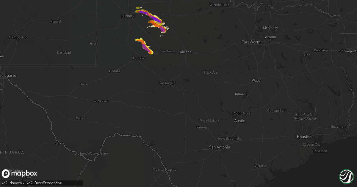
Hail Map in Texas on June 1, 2018
Get this storm
June 1 map
$229
one time, instant access
Download today. No call, no setup
Keep the $229
Bought the map and want the full workflow? Apply the entire $229 to a subscription within 7 days. None of it is wasted.
Every map, not just this one
This buys you this map. Subscription and you get every map we run, in the markets you choose from a few cities to whole states to nationwide. Plus real-time alerts the moment a storm fires.
Contact data
Name, contact info, occupancy, even credit band for addresses in the footprint. You go from where it hit to who to call.
Become the source they trust
Unlimited branding weather history reports on demand. You already have the documented answer ready for the property owner, and you are the one who showed up with it.
Property data and RoofTrace estimates
Pull up any address you have got, its value and the exact code rules for that jurisdiction, straight from One Click Code. Then RoofTrace estimates the squares, pitch, and roof value, priced the way you price.
Storm reports in Texas
Texas
| Date | Description |
|---|---|
| 06/01/20186:30 PM CDT | West texas mesonet |
| 06/01/20186:18 PM CDT | Golfball size hail covering the ground. |
| 06/01/20185:55 PM CDT | West texas mesonet |
| 06/01/20185:51 PM CDT | Picture of hail next to a quarter via social media. |
| 06/01/20185:45 PM CDT | West texas mesonet |
| 06/01/20185:45 PM CDT | Powerlines down. Reported by crosby county sheriff's office. |
| 06/01/20183:55 AM CDT | At 854 PM CDT, a severe thunderstorm was located 8 miles southeast of J B Thomas Reservoir, or 14 miles west of Colorado City, moving southeast at 20 mph. This is a very dangerous storm. HAZARD...80 mph wind gusts and baseball size hail. SOURCE...Radar indicated. IMPACT...Flying debris will be dangerous to those caught without shelter. Mobile homes will be heavily damaged. Expect considerable damage to roofs, windows, and vehicles. Extensive tree damage and power outages are likely. Locations impacted include... Colorado City, Colorado City Airport, J B Thomas Reservoir, Lake Colorado City, Lake Colorado City State Park, Champion Creek Reservoir, Westbrook, Vincent, Cuthbert and Buford.This includes Interstate 20 between mile markers 195 and 223. |
| 06/01/20183:52 AM CDT | At 852 PM CDT, a severe thunderstorm was located near Peacock, or 8 miles southeast of Jayton, moving southeast at 30 mph. HAZARD...Two inch hail and 70 mph wind gusts. SOURCE...Radar indicated. IMPACT...People and animals outdoors will be injured. Expect hail damage to roofs, siding, windows, and vehicles. Expect considerable tree damage. Wind damage is also likely to mobile homes, roofs, and outbuildings. Locations impacted include... Aspermont, Jayton, Peacock and Swenson. |
| 06/01/20183:41 AM CDT | At 841 PM CDT, a severe thunderstorm was located 7 miles south of Jayton, moving southeast at 30 mph. HAZARD...Tennis ball size hail and 70 mph wind gusts. SOURCE...Radar indicated. IMPACT...People and animals outdoors will be injured. Expect hail damage to roofs, siding, windows, and vehicles. Expect considerable tree damage. Wind damage is also likely to mobile homes, roofs, and outbuildings. Locations impacted include... Aspermont, Jayton, Peacock and Swenson. |
| 06/01/20183:11 AM CDT | At 811 PM CDT, a severe thunderstorm was located 7 miles northwest of J B Thomas Reservoir, or 13 miles southeast of Gail, moving southeast at 15 mph. This is a very dangerous storm. HAZARD...80 mph wind gusts and three inch hail. SOURCE...Radar indicated. IMPACT...Flying debris will be dangerous to those caught without shelter. Mobile homes will be heavily damaged. Expect considerable damage to roofs, windows, and vehicles. Extensive tree damage and power outages are likely. Locations impacted include... Snyder, J B Thomas Reservoir, Westbrook, Dunn, Vincent, Randalls Corner, Winston Field, Ira, Cuthbert and Knapp.This includes Interstate 20 between mile markers 201 and 206. |
| 06/01/20183:08 AM CDT | At 808 PM CDT, a severe thunderstorm was located 8 miles southeast of White River Lake, moving northeast at 25 mph. HAZARD...70 mph wind gusts and half dollar size hail. SOURCE...Radar indicated. IMPACT...Hail damage to vehicles is expected. Expect considerable tree damage. Wind damage is also likely to mobile homes, roofs, and outbuildings. Locations impacted include... Spur, Dickens and Mcadoo. |
| 06/01/20183:02 AM CDT | At 801 PM CDT, a severe thunderstorm was located near Girard, or near Jayton, moving southeast at 20 mph. A second storm was located 7 miles northwest of Claremont moving northeast near 30 mph. HAZARD...70 mph wind gusts and quarter size hail. SOURCE...Radar indicated. IMPACT...Hail damage to vehicles is expected. Expect considerable tree damage. Wind damage is also likely to mobile homes, roofs, and outbuildings. Locations impacted include... Jayton and Girard. |
| 06/01/20182:27 AM CDT | At 727 PM CDT, a severe thunderstorm was located 7 miles east of Gail, moving east at 15 mph. This is a very dangerous storm. HAZARD...80 mph wind gusts and baseball size hail. SOURCE...Radar indicated. IMPACT...Flying debris will be dangerous to those caught without shelter. Mobile homes will be heavily damaged. Expect considerable damage to roofs, windows, and vehicles. Extensive tree damage and power outages are likely. Locations impacted include... Gail, Fluvanna, Knapp and Randalls Corner. |
| 06/01/20182:11 AM CDT | At 710 PM CDT, a severe thunderstorm was located over Spur, moving southeast at 25 mph. This storm has a history of large hail and damaging winds. HAZARD...70 mph wind gusts and quarter size hail. SOURCE...Radar indicated. IMPACT...Hail damage to vehicles is expected. Expect considerable tree damage. Wind damage is also likely to mobile homes, roofs, and outbuildings. Locations impacted include... Spur, Jayton, Dickens and Girard. |
| 06/01/20181:43 AM CDT | At 642 PM CDT, a severe thunderstorm was located near Gail, moving northeast at 10 mph. HAZARD...70 mph wind gusts and quarter size hail. SOURCE...Radar indicated. IMPACT...Hail damage to vehicles is expected. Expect considerable tree damage. Wind damage is also likely to mobile homes, roofs, and outbuildings. Locations impacted include... Gail. |
| 06/01/20181:29 AM CDT | At 628 PM CDT, a severe thunderstorm was located near White River Lake, moving east at 25 mph. This storm has a history of damaging winds and large hail. HAZARD...70 mph wind gusts and quarter size hail. SOURCE...Radar indicated. IMPACT...Hail damage to vehicles is expected. Expect considerable tree damage. Wind damage is also likely to mobile homes, roofs, and outbuildings. Locations impacted include... Spur, Dickens and White River Lake. |
| 06/01/201812:46 AM CDT | At 545 PM CDT, a severe thunderstorm was located over Ralls, or near Crosbyton, moving east at 30 mph. Downed power lines were reported near Ralls at 545 pm. HAZARD...Two inch hail. SOURCE...Radar indicated. IMPACT...People and animals outdoors will be injured. Expect damage to roofs, siding, windows, and vehicles. Locations impacted include... Crosbyton and Ralls. |
| 06/01/201812:15 AM CDT | At 514 PM CDT, a severe thunderstorm was located near Cone, or 15 miles southwest of Floydada, moving northeast at 40 mph. HAZARD...Ping pong ball size hail and 60 mph wind gusts. SOURCE...Radar indicated. IMPACT...People and animals outdoors will be injured. Expect hail damage to roofs, siding, windows, and vehicles. Expect wind damage to roofs, siding, and trees. Locations impacted include... Floydada and Cone. |
| 05/31/201810:51 PM CDT | At 350 PM CDT, a severe thunderstorm was located 9 miles northwest of Marathon, or 17 miles east of Alpine, moving east at 10 mph. HAZARD...70 mph wind gusts and half dollar size hail. SOURCE...Radar indicated. IMPACT...Hail damage to vehicles is expected. Expect considerable tree damage. Wind damage is also likely to mobile homes, roofs, and outbuildings. Locations impacted include... Marathon. |
| 05/31/20189:31 PM CDT | A local report indicates 1.00 inch wind near 1 W WESTBROOK |
| 05/31/20189:07 PM CDT | A local report indicates 1.75 inch wind near 3 NW CUTHBERT |
| 05/31/20189:00 PM CDT | A local report indicates 1.50 inch wind near 5 WNW PEACOCK |
| 05/31/20188:56 PM CDT | A local report indicates 70 MPH wind near 5 ESE JAYTON |
| 05/31/20188:16 PM CDT | Public report near jb thomas. |
| 05/31/20188:14 PM CDT | Reported by coop observer. |
| 05/31/20187:30 PM CDT | A local report indicates 1.75 inch wind near 1 ESE GAIL |
| 05/31/20187:30 PM CDT | Power poles down along willow valley rd. |
| 05/31/20187:20 PM CDT | A local report indicates 69 MPH wind near 2 ESE GAIL |
| 05/31/20187:03 PM CDT | Report relayed by dickens county so |
All States Impacted by Hail Map on June 1, 2018
Cities Impacted by Hail Map on June 1, 2018
- Devils Tower, WY
- Java, SD
- Selby, SD
- Gillette, WY
- Wakpala, SD
- Lambert, MT
- Ashton, NE
- Lodge Grass, MT
- Busby, MT
- Decker, MT
- Saint Paul, NE
- Bassett, NE
- Crosby, ND
- Noonan, ND
- Columbus, ND
- Glencross, SD
- McLaughlin, SD
- Trail City, SD
- Timber Lake, SD
- Carson, ND
- Beulah, ND
- Roseglen, ND
- Ryder, ND
- Garrison, ND
- Zap, ND
- Berthold, ND
- Plaza, ND
- Makoti, ND
- Hazen, ND
- Loup City, NE
- Arcadia, NE
- Ord, NE
- Stickney, SD
- Elwood, NE
- Smithfield, NE
- Williston, ND
- Mandaree, ND
- Des Lacs, ND
- Newell, SD
- Belle Fourche, SD
- Selfridge, ND
- Watford City, ND
- Burwell, NE
- Snyder, TX
- Spur, TX
- Girard, TX
- New Salem, ND
- Overton, NE
- Elm Creek, NE
- Lexington, NE
- Bertrand, NE
- Farwell, NE
- Hazard, NE
- Rockville, NE
- Kearney, NE
- Boelus, NE
- Dannebrog, NE
- Pleasanton, NE
- Litchfield, NE
- Ravenna, NE
- Riverdale, NE
- Almont, ND
- Elgin, ND
- New Leipzig, ND
- Glen Ullin, ND
- Eagle Butte, SD
- Sundance, WY
- Newport, NE
- Rotan, TX
- Nisland, SD
- Winner, SD
- Colome, SD
- Alva, WY
- Hulett, WY
- Moorcroft, WY
- Ansley, NE
- Oconto, NE
- Broken Bow, NE
- Westerville, NE
- Fairview, MT
- Culbertson, MT
- Ray, ND
- Ainsworth, NE
- Bullhead, SD
- Sidney, MT
- Bainville, MT
- Mission, SD
- Keene, ND
- Lignite, ND
- Flaxton, ND
- Powers Lake, ND
- Taylor, NE
- Sargent, NE
- Dickens, TX
- Crosbyton, TX
- Ralls, TX
- Golden Valley, ND
- Lindsay, MT
- Jayton, TX
- Comstock, NE
- Ericson, NE
- Elyria, NE
- Cozad, NE
- Parshall, ND
- Charleston, MS
- Oakland, MS
- Valentine, NE
- Alpine, TX
- Killdeer, ND
- Elba, NE
- Miller, NE
- Gail, TX
- Oneill, NE
- Aladdin, WY
- Flasher, ND
- Dunn Center, ND
- Halliday, ND
- Epping, ND
- Fort Pierre, SD
- Grassy Butte, ND
- Richey, MT
- Forsyth, MT
- Long Pine, NE
- Ten Sleep, WY
- Circle, MT
- Garryowen, MT
- Chambers, NE
- Floydada, TX
- Aspermont, TX
- North Loup, NE
- Colorado City, TX
- Wyola, MT
- Zahl, ND
- Linton, ND
- Tioga, ND
- Ira, TX
- Westbrook, TX
- Coahoma, TX
- Johnstown, NE
- Ingraham, IL
- Noble, IL
- Amelia, NE
- Justiceburg, TX
- Lenoir, NC
- Little Eagle, SD
- Crow Agency, MT
- Hardin, MT
- Meadow Grove, NE
- Madison, NE
- Lindsay, NE
- Newman Grove, NE
- Billings, MT
- Glenham, SD
- Lorenzo, TX
- Hague, ND
- Sumner, NE
- Strasburg, ND
- Fluvanna, TX
- Sturgis, SD
- Ewing, NE
- Clearwater, NE
- Murdo, SD
- Draper, SD
- Shields, ND
- Anderson, SC
- Springview, NE
- Angela, MT
- Kinsey, MT
- Mason City, NE
- Merna, NE
- Anselmo, NE
- McIntosh, SD
- Terry, MT
- Atkinson, NE
- Saint Augustine, FL
- Brockton, MT
- Wood Lake, NE
- Amherst, NE
- Gibbon, NE
- Cairo, NE
- New Town, ND
- Courtland, MS
- Batesville, MS
- Broadus, MT
- Recluse, WY
- Bighorn, MT
- Arapahoe, NE
- Newton, IL
- Minot, ND
- Saint Xavier, MT
- Turtle Lake, ND
- Ruso, ND
- Clearmont, WY
- Columbus, IN
- Edinburgh, IN
- Shelbyville, IN
- Pope, MS
- White Owl, SD
- Clay City, IL
- Kenmare, ND
- Stanley, ND
- Union Center, SD
- Raleigh, ND
- Mobridge, SD
- Riverdale, ND
- Coleharbor, ND
- Gettysburg, SD
- Napoleon, ND
- Prairie View, KS
- Phillipsburg, KS
- Wishek, ND
- Tillatoba, MS
- Enid, MS
- Scobey, MS
- Cascilla, MS
- Mills, NE
- Post, TX
- Bemidji, MN
- Bagley, MN
- Neligh, NE
- Saint Onge, SD
- West Liberty, IL
- Custer, MT
- Thermopolis, WY
- Donnybrook, ND
- Ponte Vedra Beach, FL
- Jacksonville, FL
- Menahga, MN
- Bloomfield, MT
- Hebron, ND
- Streeter, ND
- Elkton, FL
- Brewster, NE
- Callaway, NE
- Oakdale, NE
- Elgin, NE
- Genoa, NE
- Saint Edward, NE
- Battle Creek, NE
- Humphrey, NE
- Monroe, NE


