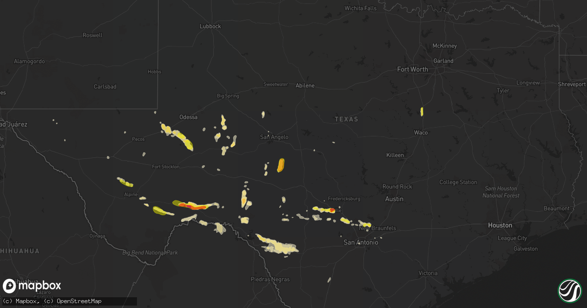
Hail Map in Texas on June 1, 2016
Get this storm
June 1 map
$229
one time, instant access
Download today. No call, no setup
Keep the $229
Bought the map and want the full workflow? Apply the entire $229 to a subscription within 7 days. None of it is wasted.
Every map, not just this one
This buys you this map. Subscription and you get every map we run, in the markets you choose from a few cities to whole states to nationwide. Plus real-time alerts the moment a storm fires.
Contact data
Name, contact info, occupancy, even credit band for addresses in the footprint. You go from where it hit to who to call.
Become the source they trust
Unlimited branding weather history reports on demand. You already have the documented answer ready for the property owner, and you are the one who showed up with it.
Property data and RoofTrace estimates
Pull up any address you have got, its value and the exact code rules for that jurisdiction, straight from One Click Code. Then RoofTrace estimates the squares, pitch, and roof value, priced the way you price.
Storm reports in Texas
Texas
| Date | Description |
|---|---|
| 06/01/20166:22 PM CDT | A local report indicates 1.00 inch wind near 5 NW BOERNE |
| 06/01/20166:10 PM CDT | A local report indicates 2.50 inch wind near 2 SE SANDERSON |
| 06/01/20166:04 PM CDT | A local report indicates 1.25 inch wind near SANDERSON |
| 06/01/20165:45 PM CDT | Reported on hwy 90 west of sanderson |
| 06/01/20165:38 PM CDT | A local report indicates 1.50 inch wind near KERRVILLE |
| 06/01/20165:18 PM CDT | A local report indicates 2.00 inch wind near 2 NW KERRVILLE |
| 06/01/20165:15 PM CDT | Quarter sized hail nearly covering the ground |
| 06/01/20165:11 PM CDT | A local report indicates 1.00 inch wind near 2 NW KERRVILLE |
| 06/01/20165:10 PM CDT | A local report indicates 1.25 inch wind near 1 WNW KERRVILLE |
| 06/01/20165:07 PM CDT | A local report indicates 1.00 inch wind near 1 NW KERRVILLE |
| 06/01/20165:00 PM CDT | Pea to ping pong ball size hail with mostly dime to quarter size. |
| 06/01/20164:13 PM CDT | A local report indicates 1.00 inch wind near KERR WILDLIFE MGMT AREA |
| 06/01/20162:50 PM CDT | A local report indicates 1.00 inch wind near 1 NE FORT DAVIS |
| 05/31/201611:22 PM CDT | A local report indicates 67 MPH wind near LAUGHLIN AFB |
| 05/31/201611:18 PM CDT | Tree limbs blown down |
| 05/31/201610:25 PM CDT | Nickel to quarter size hail observed for around 20 minutes |
| 05/31/20168:48 PM CDT | A local report indicates 1.00 inch wind near HILLSBORO |
| 05/31/20167:20 PM CDT | Ping pong to golfball size hail just off of highway 349. Time estimated from radar. |
All States Impacted by Hail Map on June 1, 2016
Cities Impacted by Hail Map on June 1, 2016
- Crane, TX
- Garden City, TX
- Calhoun Falls, SC
- Ozona, TX
- Barksdale, TX
- Rocksprings, TX
- Comstock, TX
- Dryden, TX
- Seney, MI
- Sanderson, TX
- Stevenson, AL
- Bradford, TN
- Eldorado, TX
- Christoval, TX
- Cordele, GA
- Ellaville, GA
- Hunt, TX
- Ingram, TX
- Big Lake, TX
- Union Point, GA
- Greensboro, GA
- Midkiff, TX
- Piedmont, MO
- Melvin, TX
- Lutts, TN
- Grantville, GA
- San Angelo, TX
- Abbott, TX
- Hillsboro, TX
- Pope, MS
- Enid, MS
- Robert Lee, TX
- Mountain Home, TX
- Kerrville, TX
- New Braunfels, TX
- San Antonio, TX
- Spring Branch, TX
- Bulverde, TX
- Cumming, GA
- Batesville, MS
- Alachua, FL
- Clayton, GA
- Del Rio, TX
- Brackettville, TX
- Hogansville, GA
- Lagrange, GA
- Cedartown, GA
- Uvalde, TX
- Boerne, TX
- Monahans, TX
- Lake Panasoffkee, FL
- Newberry, MI
- Stone Mountain, GA
- Lilburn, GA
- Jacksonville, FL
- Charleston, MO
- Marathon, TX
- Pecos, TX
- Lyons, GA
- Flat Rock, AL
- Greer, SC
- Rapid River, MI
- Rosiclare, IL
- Golconda, IL
- Kermit, TX
- McCamey, TX
- Rochelle, TX
- Sandersville, GA
- Elkmont, AL
- Sierra Blanca, TX
- Mount Vernon, GA
- Sparta, GA
- Buena Vista, GA
- Americus, GA
- Comfort, TX
- Patterson, MO
- Crossville, TN
- Gould City, MI
- Perronville, MI
- Ishpeming, MI
- Cynthiana, KY
- Fancy Farm, KY
- Fort Davis, TX
- Quincy, FL
- Courtland, MS
- Mount Juliet, TN
- Jasper, GA
- Hickory, KY
- Melber, KY
- Merigold, MS
- Cleveland, MS
- Pitts, GA
- Wilmot, AR
- Parkdale, AR
- Bergheim, TX
- Eddyville, KY
- Portland, AR
- Hamburg, AR
- Townsend, GA
- Balmorhea, TX
- Kingsland, AR
- Grand Marais, MI
- Salvisa, KY
- Lawrenceburg, KY
- Medina, TX
- Naples, FL
- Immokalee, FL
- Blackshear, GA
- Patterson, GA
- Tiline, KY
- Orlando, FL
- Leakey, TX
- Ardmore, AL
- Athens, AL
- Salt Flat, TX
- Madisonville, KY
- Baxley, GA
- Abbeville, SC
- Lithonia, GA
- Eddyville, IL
- Bandera, TX
- Benoit, MS
- Deltona, FL
- Box Springs, GA
- Vanderpool, TX
- Iraan, TX
- Hustonville, KY
- Bardwell, KY
- Albuquerque, NM
- Grand Rivers, KY
- Smithland, KY
- Dell City, TX
- Newberry, FL
- Gainesville, FL
- Mill Spring, MO
- Stewart, TN
- Mico, TX
- Rowesville, SC
- Cunningham, KY
- Marion, TX
- Scobey, MS
- Vernon, AL
- Stonefort, IL
- Boaz, KY
- Midland, TX
- Hollywood, AL
- Fackler, AL
- Savannah, TN
- Osceola, AR
- Fort Myers, FL
- Seguin, TX
- Stanford, KY
- Harper, TX
- Cobbtown, GA
- Collins, GA
- Woodville, AL
- Scottsboro, AL
- Fort Stockton, TX
- Glenwood, GA
- Gunnison, MS
- Puxico, MO
- Bloomfield, MO
- Gulliver, MI
- Ludowici, GA
- Bertrand, MO
- Cherokee, AL
- Tarpon Springs, FL
- Odessa, FL
- Orange City, FL
- Van Horn, TX
- Dilley, TX
- Cotulla, TX
- Brussels, WI
- Sturgeon Bay, WI
- Petersburg, TN
- Centerville, TN
- Saint George, SC
- Bowman, SC
- Norwood, GA
- Alpine, TX


