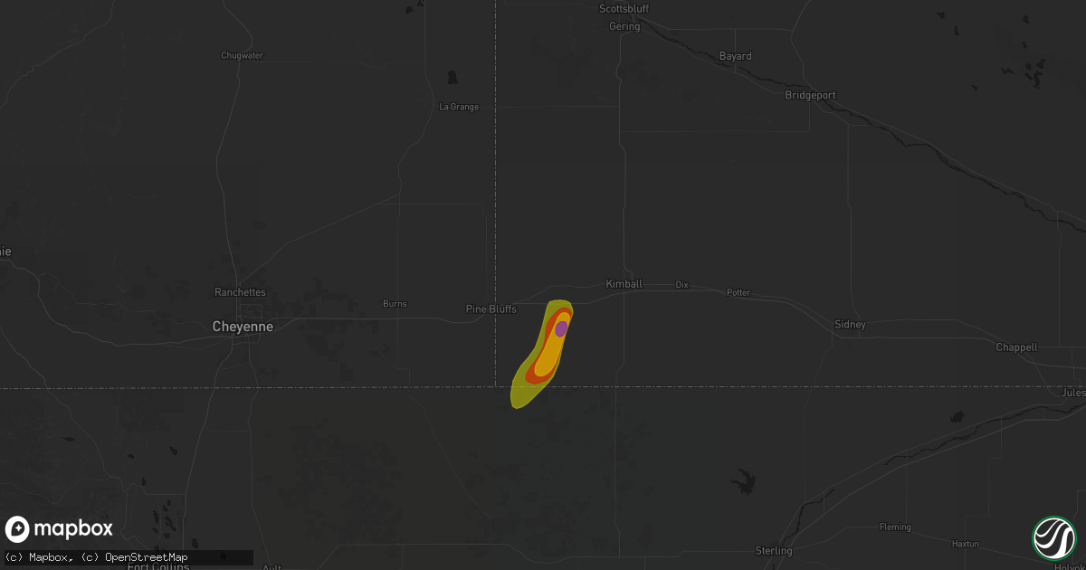
Hail Map in Bushnell, NE on May 30, 2026
Get this storm
May 30 map
$229
one time, instant access
Download today. No call, no setup
Keep the $229
Bought the map and want the full workflow? Apply the entire $229 to a subscription within 7 days. None of it is wasted.
Every map, not just this one
This buys you this map. Subscription and you get every map we run, in the markets you choose from a few cities to whole states to nationwide. Plus real-time alerts the moment a storm fires.
Contact data
Name, contact info, occupancy, even credit band for addresses in the footprint. You go from where it hit to who to call.
Become the source they trust
Unlimited branding weather history reports on demand. You already have the documented answer ready for the property owner, and you are the one who showed up with it.
Property data and RoofTrace estimates
Pull up any address you have got, its value and the exact code rules for that jurisdiction, straight from One Click Code. Then RoofTrace estimates the squares, pitch, and roof value, priced the way you price.
Storm reports in Bushnell, NE
Bushnell, NE
| Date | Description |
|---|---|
| 05/30/20265:55 PM CDT | Video confirmation of ground circulation being tilted and stretched into thunderstorm updraft. Tiny condensation funnel attached to cloud base above the ground circulat |
| 05/30/20265:55 PM CDT | Corrects previous tornado report from 9 sse bushnell. Video confirmation of ground circulation being tilted and stretched into thunderstorm updraft. Tiny condensation f |
| 05/30/20265:53 PM CDT | Corrects previous hail report from 6.3 se bushnell. Delayed report of baseball sized hail approximately 6.3 miles southeast of bushnell. Time was estimated from radar r |
| 05/30/20265:33 PM CDT | Delayed report of baseball sized hail approximately 6.3 miles southeast of bushnell. Time was estimated from radar reflectivity. Multiple windows were destroyed. |
| 05/30/20265:25 PM CDT | Kimball county em reported an ongoing tornado with debris. Was also indicated via radar imagery. |
| 05/30/20265:25 PM CDT | Corrects previous tornado report from 10 sse bushnell. Kimball county em reported an ongoing tornado. Was also indicated via radar imagery. No damage has been reported. |
| 05/30/20265:00 PM CDT | Kimball county em reported golf ball sized hail within accumulating hail... Leading to localized flash flooding in rural areas of kimball county. |
| 05/29/20269:45 PM CDT | Delayed report of around 2.5 inches of precipitation throughout the duration of the storm event near bushnell. |
All States Impacted by Hail Map on May 30, 2026
All Cities Impacted by Hail Map on May 30, 2026
- Lockwood, MO
- Oxford, KS
- Winfield, KS
- El Dorado, KS
- Arkansas City, KS
- Eureka, KS
- Junction City, KS
- Cassoday, KS
- Chapman, KS
- Maple City, KS
- Dexter, KS
- Cedar Vale, KS
- Hillsboro, KS
- Pawhuska, OK
- Latham, KS
- Florence, KS
- Cedar Point, KS
- Wann, OK
- Copan, OK
- Cabool, MO
- Houston, MO
- Willow Springs, MO
- Mountain View, MO
- Pomona, MO
- S Coffeyville, OK
- Bartlett, KS
- Deerfield, MO
- Leslie, AR
- Moundville, MO
- Bronaugh, MO
- Yates Center, KS
- Fall River, KS
- Chetopa, KS
- Clinton, AR
- Columbus, KS
- Nevada, MO
- Harrison, NE
- Jasper, AR
- Fredonia, KS
- Danville, AR
- Bee Branch, AR
- Walker, MO
- Mindenmines, MO
- Asbury, MO
- Freedom, OK
- Choctaw, AR
- Omaha, AR
- Alpena, AR
- Green Forest, AR
- Richards, MO
- Chanute, KS
- Buffalo, KS
- Harrison, AR
- Benedict, KS
- Jetmore, KS
- Liberal, MO
- Jasper, MO
- Oronogo, MO
- Torrington, WY
- Vendor, AR
- Coldwater, KS
- Edgemont, SD
- Chadron, NE
- Humboldt, KS
- Erie, KS
- Rover, AR
- Dodge City, KS
- Wright, KS
- Damascus, AR
- Lamar, MO
- Sheldon, MO
- Mount Judea, AR
- Ness City, KS
- Hanston, KS
- Hot Springs, SD
- Custer, SD
- Savonburg, KS
- Van Tassell, WY
- Hulett, WY
- Jay Em, WY
- Quitman, AR
- Benton, AR
- Lusk, WY
- Elsmore, KS
- Hollister, MO
- Kirbyville, MO
- Bazine, KS
- Western Grove, AR
- Everton, AR
- Dardanelle, AR
- Sharon, KS
- Nunn, CO
- Attica, KS
- Saint Paul, KS
- Galesburg, KS
- Stark, KS
- Brownell, KS
- Marshall, AR
- Uniontown, KS
- Fort Scott, KS
- Arma, KS
- Girard, KS
- Pittsburg, KS
- Carthage, MO
- Buffalo, SD
- Alzada, MT
- Cedarcreek, MO
- Alexander, KS
- Spearville, KS
- Medicine Lodge, KS
- Zenda, KS
- Hepler, KS
- Walnut, KS
- Spivey, KS
- Nashville, KS
- Bushnell, NE
- Isabel, KS
- Witts Springs, AR
- Manchester, OK
- Wakita, OK
- Rozel, KS
- Burdett, KS
- La Salle, CO
- Kersey, CO
- Larned, KS
- Lead, SD
- Kingman, KS
- Murdock, KS
- McCracken, KS
- Medford, OK
- Bluff City, KS
- Spearfish, SD
- Cunningham, KS
- Harper, KS
- Morrilton, AR
- Arcadia, KS
- Nekoma, KS
- Atkins, AR
- Pottsville, AR
- Anthony, KS
- Grover, CO
- Pretty Prairie, KS
- Cheney, KS
- Hays, KS
- Capitol, MT
- Rush Center, KS
- Bryant, AR
- Alexander, AR
- Briggsdale, CO
- Avilla, MO
- Reeds, MO
- Hermosa, SD
- Keystone, SD
- Belle Fourche, SD
- Ellis, KS
- Golden City, MO
- Pine Bluffs, WY
- Wray, CO
- Haigler, NE
- Argonia, KS
- Conway Springs, KS
- Farlington, KS
- Russellville, AR
- Kimball, NE
- Hay Springs, NE
- Turon, KS
- Franklin, KS
- Arlington, KS
- Carpenter, WY
- Caldwell, KS
- Freeport, KS
- Sarcoxie, MO
- Danville, KS
- Norwich, KS
- Greenfield, MO
- South Greenfield, MO
- Lamar, AR
- Clarksville, AR
- Saint Onge, SD
- Cherryvale, KS
- Wakeeney, KS
- Plainville, KS
- Milan, KS
- Viola, KS
- Milton, KS
- Hill City, SD
- La Russell, MO
- Everton, MO
- La Crosse, KS
- Bison, KS
- Albert, KS
- Otis, KS
- Pawnee Rock, KS
- Pringle, SD
- Hill City, KS
- Hagarville, AR
- Palisade, NE
- Miller, MO
- Pine Ridge, SD
- Rapid City, SD
- Champion, NE
- Morland, KS
- Aurora, MO
- Crane, MO
- Hayes Center, NE
- Bauxite, AR
- Paducah, TX
- Harrisburg, NE
- Mount Vernon, MO
- Marionville, MO
- Billings, MO
- Penokee, KS
- Ash Grove, MO
- Garden Plain, KS
- Oglala, SD
- Imperial, NE
- Haven, KS
- Andale, KS
- Colwich, KS
- Mount Hope, KS
- Lenora, KS
- Norton, KS
- Bois D Arc, MO
- Iraan, TX
- Holyoke, CO
- Republic, MO
- Sheridan, AR
- Oelrichs, SD
- Bogue, KS
- Ramah, CO
- Stotts City, MO
- Deadwood, SD
- Sheffield, TX
- Black Hawk, SD
- Walnut Grove, MO
- Olmitz, KS
- Hoisington, KS
- Agate, CO
- Inman, KS
- Springfield, MO
- Childress, TX
- Hays, MT
- Whitewood, SD
- Sturgis, SD
- Russell, KS
- Paradise, KS
- Stockton, KS
- Brookline, MO
- Willard, MO
- Halltown, MO
- Hutchinson, KS
- Burrton, KS
- Buhler, KS
- Halstead, KS
- Sedgwick, KS
- Bentley, KS
- Valley Center, KS
- Newton, KS
- Wilsonville, NE
- Cambridge, NE
- Hendley, NE
- Wallace, NE
- Elsie, NE
- Dickens, NE
- Great Bend, KS
- Lewellen, NE
- Arthur, NE
- Indianola, NE
- Bartley, NE
- Lemoyne, NE
- Glade, KS
- Pierce City, MO
- Monett, MO
- Maywood, NE
- Grant, NE
- Clayton, KS
- Verona, MO
- Phillipsburg, KS
- Bunker Hill, KS
- Freistatt, MO
- Nisland, SD
- Akron, CO
- Camp Crook, SD
- Fort Stockton, TX
- Beaver City, NE
- Ogallala, NE
- Keystone, NE
- Dorrance, KS
- Dryden, TX
- Grapevine, AR
- White Hall, AR
- Neosho, MO
- Brule, NE
- Paxton, NE
- Sutherland, NE
- Yuma, CO
- Wellfleet, NE
- Huntsville, AR
- Arapahoe, NE
- Holbrook, NE
- Claflin, KS
- Lucas, KS
- Moorefield, NE
- Stockville, NE
- Eustis, NE
- Tryon, NE
- Sylvan Grove, KS
- Wilson, KS
- Gorham, KS
- Pfeifer, KS
- Kensington, KS
- Riverton, NE
- Bloomington, NE
- Agra, KS
- Franklin, NE
- Naponee, NE
- Madrid, NE
- Hunter, KS
- Elwood, NE
- Mullen, NE
- Hyannis, NE
- Whitman, NE
- Decker, MT
- Ismay, MT
- Goddard, KS
- North Platte, NE
- Partridge, KS
- Downs, KS
- Galena, MO
- Haxtun, CO
- Gaylord, KS
- Rogers, AR
- Hindsville, AR
- Bushton, KS
- North Newton, KS
- Peabody, KS
- Walton, KS
- Lexington, NE
- Curtis, NE
- Fallon, MT
- Manderson, SD
- Ponce De Leon, MO
- Highlandville, MO
- Spokane, MO
- Abbyville, KS
- Rushville, NE
- Esbon, KS
- Lebanon, KS
- Holyrood, KS
- Lorraine, KS
- Oshkosh, NE
- Maxwell, NE
- Farnam, NE
- Smithfield, NE
- Maize, KS
- Bertrand, NE
- Overton, NE
- Cozad, NE
- Seneca, NE
- Brady, NE
- Gothenburg, NE
- Willow Island, NE
- Callaway, NE
- Oconto, NE
- Eddyville, NE
- Sumner, NE
- Arnold, NE
- Scenic, SD
- Kyle, SD
- Fordyce, AR
- Garfield, AR
- Mankato, KS
- Reeds Spring, MO
- Miller, NE
- Merriman, NE
- Campbell, NE
- Upland, NE
- Holstein, NE
- Burr Oak, KS
- Guide Rock, NE
- Red Cloud, NE
- Burns, KS
- Bearden, AR
- Eureka Springs, AR
- Hershey, NE
- Amity, AR
- Hampton, AR
- Caputa, SD
- Belfield, ND
- Ellsworth, NE
- Chestnutridge, MO
- Batesland, SD
- Thornton, AR
- Bentonville, AR
- Valentine, NE
- Thedford, NE
- Stapleton, NE
- Whitewater, KS
- Broken Bow, NE
- Mason City, NE
- Manhattan, KS
- Alta Vista, KS
- Kissee Mills, MO
- Birney, MT
- Medora, ND
- Wichita, KS
- Minden, NE
- Alliance, NE
- Taneyville, MO
- Forsyth, MO
- Ridgedale, MO
- Roseland, NE
- Bladen, NE
- Branson, MO
- Walnut Shade, MO
- Powersite, MO
- Rockaway Beach, MO
- Benton, KS
- Olsburg, KS
- Bradleyville, MO
- Greenwich, KS
- Kechi, KS
- Jersey, AR
- Banks, AR
- Belleville, KS
- New Underwood, SD
- Ansley, NE
- Andover, KS
- Waldo, KS
- Wall, SD
- Loup City, NE
- Litchfield, NE
- Geneseo, KS
- Lyons, KS
- Chester, NE
- Hebron, NE
- Hubbell, NE
- Comstock, NE
- Otter, MT
- Potwin, KS
- Arcadia, NE
- Towanda, KS
- Lindsay, MT
- Luray, KS
- Augusta, KS
- Juniata, NE
- Kenesaw, NE
- Blue Hill, NE
- Glendive, MT
- Ord, NE
- Ellsworth, KS
- Frankfort, KS
- Circle, MT
- Martin, SD
- Cottonwood Falls, KS
- Osborne, KS
- Matfield Green, KS
- Onaga, KS
- Havensville, KS
- Elyria, NE
- Strong City, KS
- Emporia, KS
- Amherst, NE
- Pleasanton, NE
- Wanblee, SD
- Rosalia, KS
- Soldier, KS
- Dorchester, NE
- Leon, KS
- Burwell, NE
- Halsey, NE
- Dunning, NE
- Kanopolis, KS
- Olpe, KS
- Council Grove, KS
- Allen, KS
- Interior, SD
- Seward, NE
- Milford, NE
- Beaver Crossing, NE
- Madison, KS
- Filley, NE
- Utica, NE
- Waco, NE
- Gresham, NE
- Martell, NE
- Roca, NE
- Hickman, NE
- Sterling, NE
- Natoma, KS
- Ainsworth, NE
- Hartford, KS
- Malcolm, NE
- Brookville, KS
- Pleasant Dale, NE
- Quinn, SD
- Hamilton, KS
- Neosho Rapids, KS
- Chambers, NE
- Lincoln, KS
- Murdo, SD
- Philip, SD
- Draper, SD
- Faith, SD
- Midland, SD
- Waverly, KS
- Burlington, KS
- Elmdale, KS
- Le Roy, KS
- Colony, KS
- Piqua, KS
- Milesville, SD
- Fort Pierre, SD
- Williamsburg, KS
- Richmond, KS
- Garnett, KS
- Westphalia, KS
- Salina, KS
- Omaha, NE
- Mineola, IA
- Silver City, IA
- Stanton, NE
- Clarkson, NE
- Neosho Falls, KS
- Blair, NE
- Presho, SD
- Welda, KS
- Kennebec, SD
- Fort Calhoun, NE
- Vivian, SD
- Pilger, NE
- Assaria, KS
- New Cambria, KS
- Hayes, SD
- Reading, KS
- Kirwin, KS
- Cedar, KS
- Abilene, KS
- Solomon, KS
- Mound City, MO
- Melvern, KS
- Admire, KS
- Eagle Butte, SD
- Blue Mound, KS
- Centerville, KS
- Quenemo, KS
- Pomona, KS
- Osage City, KS
- Woodbine, KS
- Dwight, KS
- Bedford, IA
- Lyndon, KS
- Ottawa, KS
- Herington, KS
- White City, KS
- Alma, KS
- Hope, KS
- Wellsville, KS
- Clinton, MO
- Rantoul, KS
- Paola, KS
- Paxico, KS
- Parker, KS
- Lane, KS
- Greeley, KS
- Osawatomie, KS
- Spring Hill, KS
- McFarland, KS
- Drexel, MO
- Amsterdam, MO
- Blairstown, MO
- Chilhowee, MO
- Warrensburg, MO
- Leeton, MO
- La Monte, MO
- Calhoun, MO
- Sweet Springs, MO
- Houstonia, MO
- Hughesville, MO
- Cole Camp, MO
- Lincoln, MO
- Marshall, MO
- Greenbrier, AR


