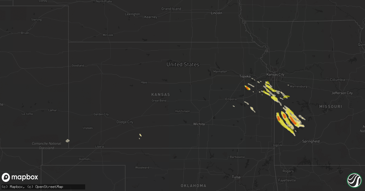
Hail Map in Kansas on May 30, 2017
Get this storm
May 30 map
$229
one time, instant access
Download today. No call, no setup
Keep the $229
Bought the map and want the full workflow? Apply the entire $229 to a subscription within 7 days. None of it is wasted.
Every map, not just this one
This buys you this map. Subscription and you get every map we run, in the markets you choose from a few cities to whole states to nationwide. Plus real-time alerts the moment a storm fires.
Contact data
Name, contact info, occupancy, even credit band for addresses in the footprint. You go from where it hit to who to call.
Become the source they trust
Unlimited branding weather history reports on demand. You already have the documented answer ready for the property owner, and you are the one who showed up with it.
Property data and RoofTrace estimates
Pull up any address you have got, its value and the exact code rules for that jurisdiction, straight from One Click Code. Then RoofTrace estimates the squares, pitch, and roof value, priced the way you price.
Storm reports in Kansas
Kansas
| Date | Description |
|---|---|
| 05/30/20176:57 PM CDT | Miami county sheriff's dept reported quarter size hail. |
| 05/30/20176:56 PM CDT | Dime to quarter size hail in downtown paola. Via twitter. |
| 05/30/20176:47 PM CDT | Quarter size hail reported at the intersection of 287th st and osawatomie rd. Via twitter. |
| 05/30/20176:39 PM CDT | Nickel to quarter size hail reported at casey's general store. |
| 05/30/20176:06 PM CDT | Nickel to quarter size hail reported in olathe via twitter. |
| 05/29/20177:44 PM CDT | A local report indicates 1.00 inch wind near 6 S OVERBROOK |
| 05/29/20177:43 PM CDT | Lots of quarter size hail and some up to golf ball size covering the ground. |
| 05/29/20177:40 PM CDT | Spotter didn't get to actually observe any hail size. But... Did find extensive crop damage north of the location about 1 mile which is about 4.5 miles sw of overbrook. |
All States Impacted by Hail Map on May 30, 2017
Cities Impacted by Hail Map on May 30, 2017
- Lockwood, MO
- Pueblo, CO
- Moore Haven, FL
- Clewiston, FL
- Jeffersonton, VA
- Rixeyville, VA
- Remington, VA
- Bucyrus, KS
- Louisburg, KS
- Hilliard, FL
- Garden City, MO
- Nevada, MO
- Lamar, MO
- Greenfield, MO
- South Greenfield, MO
- Sheldon, MO
- Deerfield, MO
- Richards, MO
- Rich Hill, MO
- Hume, MO
- Moundville, MO
- Jerico Springs, MO
- Milo, MO
- Brockway, PA
- Lonoke, AR
- Wauchula, FL
- Zolfo Springs, FL
- Stanley, NY
- Clifton Springs, NY
- Windermere, FL
- Adrian, MO
- Berryville, VA
- Drexel, MO
- Butler, MO
- La Cygne, KS
- Amsterdam, MO
- Sparta, TN
- Penfield, PA
- Du Bois, PA
- Reynoldsville, PA
- Rockton, PA
- El Dorado Springs, MO
- Stockton, MO
- Colony, KS
- Westphalia, KS
- Eutaw, AL
- Knoxville, AL
- Osceola, MO
- James Creek, PA
- Saxton, PA
- Dudley, PA
- Sonora, TX
- Ozona, TX
- Olathe, KS
- Gardner, KS
- Hohenwald, TN
- Ragland, AL
- Ohatchee, AL
- Dunnegan, MO
- Fair Play, MO
- Warrenton, VA
- Marshall, VA
- King George, VA
- Monticello, GA
- Hillsboro, GA
- Eatonton, GA
- Mahaffey, PA
- Punxsutawney, PA
- Big Run, PA
- Luthersburg, PA
- Clearfield, PA
- Curwensville, PA
- Grampian, PA
- Protection, KS
- Needmore, PA
- Warfordsburg, PA
- Woodbury, PA
- Martinsburg, PA
- Broad Top, PA
- Oliver Springs, TN
- Wartburg, TN
- Paola, KS
- Stafford, VA
- Harrisonville, MO
- Alexandria, PA
- Huntingdon, PA
- Tyrone, PA
- Hollidaysburg, PA
- Williamsburg, PA
- Altoona, PA
- Petersburg, PA
- Ashville, PA
- Dysart, PA
- Del Rio, TX
- Fredericksburg, VA
- Pottersdale, PA
- Kylertown, PA
- Karthaus, PA
- Beech Creek, PA
- Orviston, PA
- Lanse, PA
- Philipsburg, PA
- Bellefonte, PA
- Snow Shoe, PA
- Clarence, PA
- Drifting, PA
- Moshannon, PA
- Frenchville, PA
- Grassflat, PA
- Morrisdale, PA
- Floresville, TX
- El Paso, TX
- Montevallo, AL
- Townsend, GA
- Manns Choice, PA
- Bedford, PA
- Quenemo, KS
- Overbrook, KS
- Pomona, KS
- Scranton, KS
- Vassar, KS
- Waverly, KS
- Smyrna, NC
- Beaufort, NC
- Stephenson, VA
- Jenkinsburg, GA
- Flovilla, GA
- Jackson, GA
- Griffin, GA
- Locust Grove, GA
- Brunswick, GA
- Hartsville, TN
- Golden Meadow, LA
- North Little Rock, AR
- Woodbine, GA
- Yulee, FL
- Kingsland, GA
- Luray, TN
- Labelle, FL
- Schell City, MO
- Linden, TN
- Springville, TN
- Big Sandy, TN
- Paris, TN
- Rockville, MO
- Dadeville, MO
- Harriman, TN
- Saint Johns, FL
- Saint Augustine, FL
- Green Cove Springs, FL
- Alexandria, TN
- Covington, TN
- Mason, TN
- Brighton, TN
- Boston, VA
- Bealeton, VA
- Catlett, VA
- Castleton, VA
- Brandy Station, VA
- Midland, VA
- Stacy, NC
- Marshallberg, NC
- Davis, NC
- Morehead City, NC
- Gloucester, NC
- Jacksonville, FL
- Walkerton, VA
- Saint Stephens Church, VA
- Bruington, VA
- Rexville, NY
- Harrison Valley, PA
- Ulysses, PA
- Whitesville, NY
- Genesee, PA
- Bessemer, AL
- Elkton, FL
- Kittanning, PA
- Carbondale, KS
- Harper, TX
- Spring Hill, KS
- Edgerton, KS
- Cleveland, MO
- New Century, KS
- Harwood, MO
- McEwen, TN
- Dickson, TN
- Oak Grove, LA
- Sorrento, FL
- Longwood, FL
- Apopka, FL
- Lake Mary, FL
- Immokalee, FL
- Walsh, CO
- Elkhart, KS
- Humansville, MO
- Collins, MO
- Bolivar, MO
- Appleton City, MO
- Walker, MO
- Rappahannock Academy, VA
- Colonial Beach, VA
- Bunnell, FL
- Amissville, VA
- Quantico, VA
- Woodville, VA
- Culpeper, VA
- Triangle, VA
- Centerville, TN
- Winchester, VA
- Darien, GA
- Burlington, KS
- Arkport, NY
- Hornell, NY
- Riceboro, GA
- Nunnelly, TN
- Almond, NY
- Steens, MS
- Columbus, MS
- Polk City, FL
- Lafayette, TN
- Theriot, LA
- Lebanon, TN
- Watertown, TN
- Jacksonville, AR
- Birmingham, AL
- Lawrence, KS
- Baldwin City, KS
- Eudora, KS
- Beech Bluff, TN
- Weaubleau, MO
- Pleasant Plains, AR
- Newark, NY
- Shortsville, NY
- Lyons, NY
- Phelps, NY
- Canandaigua, NY
- Geneva, NY
- Valier, PA
- Hamilton, PA
- Freeman, MO
- Archie, MO
- Elmendorf, TX
- Troutville, PA
- Walston, PA
- Smicksburg, PA
- San Antonio, TX
- Adkins, TX
- Bluemont, VA
- Clear Brook, VA
- West Blocton, AL
- Auburndale, FL
- Floral, AR
- White Oak, GA
- Las Cruces, NM
- Mesilla Park, NM
- Warriors Mark, PA
- Orlando, FL
- La Mesa, NM
- Chamberino, NM
- Baxter, TN
- Roopville, GA
- Franklin, GA
- Purcellville, VA
- Harpers Ferry, WV
- Charles Town, WV
- Round Hill, VA
- Lyles, TN
- Duck River, TN
- Willcox, AZ
- Milledgeville, GA
- Sparta, GA
- Hartford, KS
- Madison, KS
- Newberry, FL
- Dulac, LA
- Chauvin, LA
- Callahan, FL
- Flemington, MO
- Brookville, PA
- Port Sulphur, LA
- Jackson, TN
- Kenton, OK
- Monticello, KY
- Waverly, TN
- Sproul, PA
- Roaring Spring, PA
- Queen, PA
- Imler, PA
- Claysburg, PA
- Culleoka, TN
- Columbia, TN
- Grand Island, FL
- Galliano, LA
- Cut Off, LA
- Sumerduck, VA
- Palatka, FL
- Mount Juliet, TN
- Alachua, FL
- Arcola, MO
- Augusta, AR
- Farmington, PA
- Ohiopyle, PA
- Howard, PA
- Kingsville, MO
- Columbia, KY
- Sykesville, PA
- Summit Point, WV
- Bunker Hill, WV
- Kearneysville, WV
- Dixon Springs, TN
- Newport, AR
- Wellsville, KS
- Leechburg, PA
- Smithville, TN
- Silver Point, TN
- Coolspring, PA
- Woodland, PA
- Stump Creek, PA
- Dayton, PA
- Summerville, PA
- Mayport, PA
- Northpoint, PA
- Worthville, PA
- Sprankle Mills, PA
- La Harpe, KS
- Jones, LA
- Lancing, TN
- Fleming Island, FL
- Orange Park, FL
- Bradford, AR
- Pearce, AZ
- Kings Bay, GA
- Bloomington Springs, TN
- Austin, PA
- Roulette, PA
- Amagon, AR
- Ottawa, KS
- Rantoul, KS
- Morriston, FL
- Pleasant Hill, MO
- Elkwood, VA
- Olive Branch, MS
- Osawatomie, KS
- Coudersport, PA
- Greenwood, NY
- Springfield, CO
- Hastings, FL
- Huntly, VA
- Flint Hill, VA
- Roswell, NM
- Cassville, PA
- Todd, PA
- Winburne, PA
- Scott, AR
- Andover, NY
- Alfred Station, NY
- Lobelville, TN
- Hortense, GA
- Lecompton, KS
- Clifton, TN
- Decaturville, TN
- Bath Springs, TN
- Nokesville, VA
- Washington, VA
- Woodford, VA
- Goldvein, VA
- Mount Dora, FL
- Jasper, NY
- Cameron, NY
- Canisteo, NY
- Spring Hill, TN
- Saint Marys, GA
- Creighton, MO
- Lyndon, KS
- Bronaugh, MO


