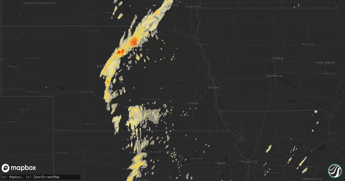
Hail Map in Kansas on May 30, 2011
Get this storm
May 30 map
$229
one time, instant access
Download today. No call, no setup
Keep the $229
Bought the map and want the full workflow? Apply the entire $229 to a subscription within 7 days. None of it is wasted.
Every map, not just this one
This buys you this map. Subscription and you get every map we run, in the markets you choose from a few cities to whole states to nationwide. Plus real-time alerts the moment a storm fires.
Contact data
Name, contact info, occupancy, even credit band for addresses in the footprint. You go from where it hit to who to call.
Become the source they trust
Unlimited branding weather history reports on demand. You already have the documented answer ready for the property owner, and you are the one who showed up with it.
Property data and RoofTrace estimates
Pull up any address you have got, its value and the exact code rules for that jurisdiction, straight from One Click Code. Then RoofTrace estimates the squares, pitch, and roof value, priced the way you price.
Storm reports in Kansas
Kansas
| Date | Description |
|---|---|
| 05/30/20116:13 PM CDT | Blowing dust reducing visibility to a few miles. |
| 05/29/201111:30 PM CDT | Also received 1/2 inch diameter hail. |
| 05/29/201111:27 PM CDT | A local report indicates 60 MPH wind near 9 SSE BELLEVILLE |
| 05/29/201111:22 PM CDT | A local report indicates 1.00 inch wind near SYLVAN GROVE |
| 05/29/201111:22 PM CDT | A local report indicates 58 MPH wind near 6 N SYLVAN GROVE |
| 05/29/201111:22 PM CDT | A local report indicates 65 MPH wind near SYLVAN GROVE |
| 05/29/201111:20 PM CDT | A local report indicates 60 MPH wind near PAWNEE ROCK |
| 05/29/201111:18 PM CDT | A local report indicates 60 MPH wind near BUNKER HILL |
| 05/29/201111:17 PM CDT | A local report indicates 1.00 inch wind near BUNKER HILL |
| 05/29/201111:12 PM CDT | A local report indicates 60 MPH wind near 3 ESE JAMESTOWN |
| 05/29/201111:02 PM CDT | A local report indicates 60 MPH wind near WILSON LAKE |
| 05/29/201110:55 PM CDT | A local report indicates 60 MPH wind near SUSANK |
| 05/29/201110:55 PM CDT | A local report indicates 1.00 inch wind near W BISON |
| 05/29/201110:49 PM CDT | A local report indicates 60 MPH wind near TIPTON |
| 05/29/201110:45 PM CDT | A local report indicates 65 MPH wind near MILBERGER |
| 05/29/201110:44 PM CDT | Public report was relayed by law enforcement. |
| 05/29/201110:37 PM CDT | Measured at home weather station. Reported from media. |
| 05/29/201110:34 PM CDT | A local report indicates 63 MPH wind near MILBERGER |
| 05/29/201110:25 PM CDT | A local report indicates 60 MPH wind near 10 N RUSSELL |
| 05/29/201110:10 PM CDT | A local report indicates 60 MPH wind near 6 NE VICTORIA |
| 05/29/201110:10 PM CDT | A local report indicates 60 MPH wind near BURR OAK |
| 05/29/201110:09 PM CDT | A local report indicates 1.00 inch wind near 6 N ESBON |
| 05/29/201110:05 PM CDT | A local report indicates 1.00 inch wind near 2 W PARADISE |
| 05/29/20119:53 PM CDT | 60kt wind gusts at airport |
| 05/29/20119:44 PM CDT | A local report indicates 1.00 inch wind near ALTON |
| 05/29/20118:58 PM CDT | Measured at phillipsburg airport |
All States Impacted by Hail Map on May 30, 2011
Cities Impacted by Hail Map on May 30, 2011
- Ipswich, SD
- Cresbard, SD
- Phillipsburg, KS
- Crosbyton, TX
- Lebo, KS
- Melvern, KS
- Waverly, KS
- Remer, MN
- Spring Valley, WI
- Creighton, NE
- Wannaska, MN
- Superior, NE
- Olsburg, KS
- Britton, SD
- Hamill, SD
- Winner, SD
- Gregory, SD
- Colome, SD
- Donnelly, MN
- Abilene, KS
- Wessington, SD
- Paducah, TX
- Arbela, MO
- Kimball, SD
- Henning, MN
- Bassett, NE
- Purdum, NE
- Long Pine, NE
- Newport, NE
- Burwell, NE
- Ainsworth, NE
- Brewster, NE
- Dunning, NE
- Upland, NE
- Comstock, NE
- Westerville, NE
- Broken Bow, NE
- Ansley, NE
- Oneill, NE
- Stuart, NE
- Atkinson, NE
- Perham, MN
- Campbell, NE
- Princeton, KS
- Williamsburg, KS
- Otis, KS
- Albert, KS
- Wellington, KS
- Mayfield, KS
- Milan, KS
- Fayette, MO
- New Franklin, MO
- Rocheport, MO
- Hanston, KS
- Spearville, KS
- Kinsley, KS
- Larned, KS
- Minneola, KS
- Bucklin, KS
- Stockton, KS
- Herman, MN
- Norcross, MN
- Osborne, KS
- Tipton, KS
- Pawnee Rock, KS
- Wagner, SD
- Lidgerwood, ND
- Axtell, NE
- Esbon, KS
- Hayti, SD
- Emery, SD
- Park Rapids, MN
- Quanah, TX
- Miller, SD
- Wessington Springs, SD
- Fort Thompson, SD
- Gann Valley, SD
- Smith Center, KS
- Riverton, NE
- New York Mills, MN
- Menahga, MN
- Stone Lake, WI
- Doland, SD
- Alton, KS
- La Crosse, KS
- Waldo, KS
- Rush Center, KS
- Paradise, KS
- Hoisington, KS
- Bison, KS
- Burdett, KS
- Rozel, KS
- Luray, KS
- Walker, KS
- Gorham, KS
- Lucas, KS
- Bunker Hill, KS
- Natoma, KS
- Russell, KS
- Nekoma, KS
- Victoria, KS
- Pfeifer, KS
- Danbury, WI
- Webster, WI
- Delmont, SD
- Parkston, SD
- Almena, KS
- Stamford, NE
- Long Island, KS
- Lake Andes, SD
- Lynch, NE
- Novelty, MO
- Childress, TX
- Deweese, NE
- Clay Center, NE
- Fairfield, NE
- Glenvil, NE
- Nelson, NE
- Colfax, WI
- Ridgeland, WI
- Somerset, WI
- Osceola, WI
- Marine On Saint Croix, MN
- Eddyville, NE
- Republican City, NE
- Naponee, NE
- Hager City, WI
- Red Wing, MN
- Welch, MN
- Goodridge, MN
- Offerle, KS
- Heartwell, NE
- Minden, NE
- Clark, MO
- Downs, KS
- Gaylord, KS
- Elbow Lake, MN
- Ashby, MN
- Bagley, MN
- Avon, SD
- Dante, SD
- Reynolds, ND
- Thompson, ND
- Fisher, MN
- Buxton, ND
- Amelia, NE
- Kenesaw, NE
- Shelton, NE
- Gibbon, NE
- Frankfort, SD
- Garfield, MN
- Kensington, MN
- Farwell, MN
- Roach, MO
- Camdenton, MO
- Macks Creek, MO
- Caldwell, KS
- Medford, OK
- South Haven, KS
- Wilber, NE
- Mason City, NE
- Oconto, NE
- Alva, OK
- Gaylord, MN
- Dallas, SD
- Protection, KS
- Rosston, OK
- Ashland, KS
- Buffalo, OK
- Oxford, NE
- Edison, NE
- Spencer, NE
- Courtland, KS
- Richville, MN
- Dent, MN
- Mullinville, KS
- Haviland, KS
- Frederic, WI
- Luck, WI
- Hopkins, MN
- Minneapolis, MN
- Elkton, SD
- Watertown, SD
- Clyde, KS
- Crete, NE
- Dorchester, NE
- Tulare, SD
- Redfield, SD
- New Ulm, MN
- Duncan, OK
- Wilcox, NE
- Holstein, NE
- Bladen, NE
- Kearney, NE
- Bloomington, NE
- Franklin, NE
- Hildreth, NE
- Marshall, MO
- Slater, MO
- Chambers, NE
- Kersey, CO
- Fort Lupton, CO
- Keenesburg, CO
- La Salle, CO
- Hudson, CO
- Reliance, SD
- Cushing, MN
- Little Falls, MN
- Randall, MN
- Kennebec, SD
- St John, KS
- Floydada, TX
- Hurley, WI
- Cushing, OK
- Stroud, OK
- Bay Minette, AL
- Sebeka, MN
- Starbuck, MN
- Cayuga, ND
- Milnor, ND
- Rutland, ND
- Naytahwaush, MN
- Ponsford, MN
- Waubun, MN
- Ellsworth, WI
- Bay City, WI
- Ontonagon, MI
- Bergland, MI
- White Pine, MI
- Siren, WI
- Backus, MN
- Pine River, MN
- Climax Springs, MO
- Arnold, NE
- Belle Plaine, MN
- Henderson, MN
- Le Sueur, MN
- Saint Peter, MN
- Pine City, MN
- Kensington, KS
- Tilden, NE
- Spur, TX
- Ralls, TX
- Summit, SD
- Sarona, WI
- Brandon, MN
- Great Bend, KS
- Centerview, MO
- Minneapolis, KS
- Solomon, KS
- Bartlett, NE
- Eldorado, OK
- Conde, SD
- Lowry, MN
- Alexandria, MN
- Mount Sterling, IA
- Keosauqua, IA
- Lexington, NE
- Battle Lake, MN
- Armour, SD
- Ethan, SD
- Dimock, SD
- Tripp, SD
- Taylor, NE
- Pickstown, SD
- Alexandria, SD
- Fairfax, SD
- Bristow, NE
- Butte, NE
- Spencer, SD
- Ault, CO
- Bridgewater, SD
- Spooner, WI
- Westphalia, KS
- Merna, NE
- Andover, SD
- East Grand Forks, MN
- Climax, MN
- Shakopee, MN
- Lorenzo, TX
- Bertrand, NE
- Wellington, TX
- Eustis, NE
- Elwood, NE
- Grantsburg, WI
- Athol, KS
- Corsica, SD
- Peever, SD
- Hazel, SD
- Lake Preston, SD
- Erwin, SD
- Bryant, SD
- Lake Norden, SD
- Ewing, NE
- Evansville, MN
- Montrose, SD
- Ford, KS
- Columbia, MO
- Jamestown, MO
- Verdigre, NE
- Salem, SD
- Belleville, KS
- Juniata, NE
- Maple Lake, MN
- Lincoln, KS
- Walters, OK
- Sheldon, ND
- Partridge, KS
- Saint James, MN
- Bonesteel, SD
- Knapp, WI
- Boyceville, WI
- Glidden, WI
- Correll, MN
- Hastings, NE
- Inland, NE
- Lawrence, NE
- Harvard, NE
- Winfred, SD
- Matador, TX
- Roaring Springs, TX
- Hancock, MN
- Brighton, CO
- Lost Springs, KS
- Herington, KS
- Frederick, OK
- Snyder, OK
- Cache, OK
- Tipton, OK
- Indiahoma, OK
- Woodston, KS
- Kirwin, KS
- Eaton, CO
- Claremont, SD
- Comanche, OK
- Portis, KS
- Funk, NE
- Belpre, KS
- Glyndon, MN
- Anselmo, NE
- Callaway, NE
- Eden Prairie, MN
- Shell Lake, WI
- Barronett, WI
- Pratt, KS
- Loup City, NE
- Lake City, KS
- Longford, KS
- Boonville, MO
- Canova, SD
- Underwood, MN
- Marlow, OK
- Orleans, NE
- Holdrege, NE
- Atlanta, NE
- Wakefield, KS
- Junction City, KS
- Naper, NE
- Shevlin, MN
- Roseland, NE
- Saronville, NE
- Cedar, MN
- Anoka, MN
- Bethel, MN
- Rush City, MN
- Burr Oak, KS
- Mankato, KS
- Doniphan, NE
- Geneva, NE
- Emmet, NE
- Cozad, NE
- Gothenburg, NE
- Stratford, SD
- Bessemer, MI
- Wakefield, MI
- Dumont, MN
- Ortonville, MN
- Chokio, MN
- Clinton, MN
- Platte, SD
- Smithfield, NE
- Cumberland, WI
- Langford, SD
- Pierpont, SD
- Morris, MN
- Monticello, MN
- Felton, MN
- Gould, OK
- Cee Vee, TX
- Tell, TX
- Norway, KS
- Jamestown, KS
- Scandia, KS
- Harrisburg, MO
- Miltonvale, KS
- Fort Ripley, MN
- Osage, MN
- Hickman, NE
- Roca, NE
- Ortley, SD
- Zenda, KS
- Salisbury, MO
- Keytesville, MO
- Hitchcock, SD
- Randolph, NE
- Carver, MN
- Glenwood, MN
- Concordia, KS
- Milaca, MN
- Pease, MN
- Coldwater, KS
- Wood River, NE
- Trego, WI
- Bennett, CO
- Jewell, KS
- Ashton, SD
- Turton, SD
- Mellette, SD
- Brentford, SD
- Hinckley, MN
- Fort Supply, OK
- Medicine Lodge, KS
- Walcott, ND
- Lower Brule, SD
- Memphis, MO
- Enderlin, ND
- Riverdale, NE
- Onaga, KS
- Vermillion, KS
- Davenport, NE
- Barrett, MN
- Wilmot, SD
- Norfolk, NE
- Frazee, MN
- Mellen, WI
- Hayward, WI
- Cable, WI
- Clam Lake, WI
- Ponca City, OK
- Eureka, KS
- Odessa, MO
- Dickens, TX
- Amorita, OK
- Marengo, WI
- Springbrook, WI
- Canistota, SD
- Burlington, OK
- Laporte, MN
- Solway, MN
- Howard Lake, MN
- Waverly, MN
- Loveland, OK
- Hollister, OK
- Garnett, KS
- Dalton, MN
- Wilson, KS
- Lebanon, KS
- Buffalo, MN
- Saint Michael, MN
- Green Isle, MN
- Arlington, MN
- Grygla, MN
- Middle River, MN
- Freedom, OK
- Western, NE
- High Bridge, WI
- Huron, SD
- Virgil, SD
- Arthur, ND
- Center, NE
- Formoso, KS
- Edgar, NE
- Sutton, NE
- Augusta, KS
- El Dorado, KS
- Clarissa, MN
- Oldham, SD
- De Smet, SD
- Norwood Young America, MN
- Hamburg, MN
- Roslyn, SD
- Stirum, ND
- Ashland, WI
- Mason, WI
- Oak, NE
- Groton, SD
- Bristol, SD
- Ferney, SD
- Adams, MN
- Taopi, MN
- Assaria, KS
- Ericson, NE
- Attica, KS
- Claire City, SD
- Big Lake, MN
- Havensville, KS
- Corning, KS
- Douglass, KS
- Crosby, MN
- Slaton, TX
- Hazelton, KS
- Waldron, KS
- Kiowa, KS
- Cogswell, ND
- Cushing, WI
- Oshkosh, NE
- Henderson, NE
- Grafton, NE
- Saint Paul, MN
- Hanska, MN
- Burns, KS
- Aurora, SD
- White, SD
- Elk River, MN
- Brunswick, NE
- Plainview, NE
- Paris, MO
- Veblen, SD
- Lake City, SD
- Lancaster, MN
- Lewis, KS
- Birchwood, WI
- Holden, MO
- Red Cloud, NE
- Howard, SD
- Chillicothe, TX
- Minto, ND
- Headrick, OK
- Altus, OK
- Elmer, OK
- Tampa, KS
- Durham, KS
- Ayr, NE
- Wolsey, SD
- Montrose, MN
- Grand Forks, ND
- Winfield, KS
- Arkansas City, KS
- Knox City, MO
- Rutledge, MO
- La Belle, MO
- Wyaconda, MO
- Chamberlain, SD
- Raymond, KS
- Hope, KS
- Hebron, NE
- Lafayette, MN
- Guide Rock, NE
- Ellsworth, KS
- Cedar, KS
- Norborne, MO
- Braymer, MO
- Richmond, MO
- Amery, WI
- Page, ND
- Clarks, NE
- Becker, MN
- Burke, SD
- Saint Charles, SD
- Deer Creek, MN
- Vining, MN
- Cyrus, MN
- Parkers Prairie, MN
- Miltona, MN
- Montreal, WI
- Braham, MN
- Stanchfield, MN
- York, NE
- Lake George, MN
- Carlos, MN
- California, MO
- Wooldridge, MO
- Loomis, NE
- New Auburn, WI
- Republic, KS
- Shickley, NE
- Wyndmere, ND
- Hardin, MO
- Lake Benton, MN
- Pierce, NE
- Oacoma, SD
- Afton, TX
- Ironwood, MI
- Kingman, KS
- Greensburg, KS
- Havana, ND
- Agra, KS
- Inavale, NE
- Blue Hill, NE
- Sylvan Grove, KS
- Raymond, SD
- Clay Center, KS
- Olmitz, KS
- Hunter, KS
- Cawker City, KS
- Dorrance, KS
- Fairmont, NE
- Ellinwood, KS
- Grandin, ND
- Hillsboro, ND
- Maiden Rock, WI
- Goodhue, MN
- Frontenac, MN
- Mount Vernon, SD
- Sabin, MN
- Bemidji, MN
- Tenstrike, MN
- Hoffman, MN
- Hugo, MN
- Stillwater, MN
- Alda, NE
- Foreston, MN
- Munden, KS
- Annandale, MN
- Niobrara, NE
- Glasgow, MO
- Wilson, TX
- Tahoka, TX
- Lisbon, ND
- Sargent, NE
- Harris, MN
- Stafford, KS
- Graceville, MN
- Roggen, CO
- Aurora, NE
- Dalbo, MN
- Princeton, MN
- Lyle, MN
- Rose Creek, MN
- Cologne, MN
- Casselton, ND
- Amenia, ND
- Marysville, KS
- Blue Rapids, KS
- Delphos, KS
- Aurora, KS
- Glasco, KS
- Macksville, KS
- Madison, MO
- Claflin, KS
- Comstock, WI
- Burdick, KS
- Milltown, WI
- Centuria, WI
- Cannon Falls, MN
- Sturgeon, MO
- Castlewood, SD
- Trout Creek, MI
- Mapleton, ND
- Springfield, SD
- Arlington, KS
- Saxon, WI
- Nielsville, MN
- Fort Ransom, ND
- Rochert, MN
- Detroit Lakes, MN
- Mills, NE
- Willow Island, NE
- Madison, SD
- Mitchell, SD
- Geddes, SD
- Sumner, NE
- Olivet, SD
- Fulton, SD
- Outing, MN
- Washington, KS
- Turtle Lake, WI
- Balsam Lake, WI
- Dresser, WI
- Martell, NE
- Vergas, MN
- Warren, MN
- Oakdale, NE
- Alvarado, MN
- Anthony, KS
- Burlington, KS
- Browerville, MN
- Saint Ansgar, IA
- Seneca, KS
- Giltner, NE
- Deshler, NE
- Sharon, KS
- Dalton, MO
- Saint Croix Falls, WI
- Nelson, MN
- Lengby, MN
- Hudson, KS
- River Falls, WI
- Geuda Springs, KS
- Mcadoo, TX
- Wilmore, KS
- Bucklin, MO
- Marceline, MO
- Coats, KS
- Appleton, MN
- Arapahoe, NE
- Lake City, MN
- Clearwater, NE
- Elgin, NE
- Gilliam, MO
- Ottawa, KS
- Richmond, KS
- Ong, NE
- Mansfield, SD
- Northville, SD
- Lamont, OK
- Clayton, WI
- Excelsior, MN
- Erhard, MN
- Horace, ND
- Fargo, ND
- Olustee, OK
- Hubbell, NE
- Inman, NE
- Barnesville, MN
- Clearwater, MN
- Clear Lake, MN
- Tunas, MO
- Chandler, OK
- Carney, OK
- Warrensburg, MO
- Foss, OK
- Memphis, TX
- Drayton, ND
- Grafton, ND
- Iuka, KS
- Beaver City, NE
- Hutchinson, KS


