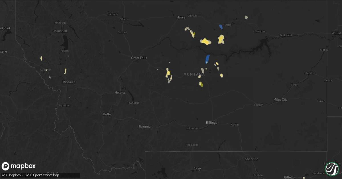
Hail Map in Montana on May 29, 2026
Get this storm
May 29 map
$229
one time, instant access
Download today. No call, no setup
Keep the $229
Bought the map and want the full workflow? Apply the entire $229 to a subscription within 7 days. None of it is wasted.
Every map, not just this one
This buys you this map. Subscription and you get every map we run, in the markets you choose from a few cities to whole states to nationwide. Plus real-time alerts the moment a storm fires.
Contact data
Name, contact info, occupancy, even credit band for addresses in the footprint. You go from where it hit to who to call.
Become the source they trust
Unlimited branding weather history reports on demand. You already have the documented answer ready for the property owner, and you are the one who showed up with it.
Property data and RoofTrace estimates
Pull up any address you have got, its value and the exact code rules for that jurisdiction, straight from One Click Code. Then RoofTrace estimates the squares, pitch, and roof value, priced the way you price.
Storm reports in Montana
Montana
| Date | Description |
|---|---|
| 05/28/202611:15 PM CDT | Mesonet station mtstm st. Marie mt-24 mp 18.0. |
| 05/28/20269:00 PM CDT | Wagm8 mesonet observation site. |
| 05/28/20268:25 PM CDT | Straight-line winds knocked down multiple tree limbs and caused the power to go out. Nearby automated sensors were gusting 35-40 mph. |
| 05/28/20267:30 PM CDT | A local report indicates 70 MPH wind near 13 ENE Roy |
All States Impacted by Hail Map on May 29, 2026
Cities Impacted by Hail Map on May 29, 2026
- Pueblo, CO
- Avondale, CO
- Colorado Springs, CO
- Peyton, CO
- Lead, SD
- Watonga, OK
- Hitchcock, OK
- Fairview, OK
- Kit Carson, CO
- Superior, MT
- Kingfisher, OK
- Okeene, OK
- Alberton, MT
- Hennessey, OK
- Ames, OK
- Waukomis, OK
- Drummond, OK
- Enid, OK
- Chinook, MT
- Geyser, MT
- Ringwood, OK
- Forest Grove, MT
- Meno, OK
- Stratton, CO
- Lahoma, OK
- Carrier, OK
- Hays, MT
- Isabella, OK
- Grass Range, MT
- Stanford, MT
- Bethune, CO
- Zortman, MT
- Hobson, MT
- Goltry, OK
- Helena, OK
- Kremlin, OK
- Clarendon, TX
- Plains, MT
- Saint Regis, MT
- Nash, OK
- Arlee, MT
- Frenchtown, MT
- Cheyenne Wells, CO
- Quitaque, TX
- Missoula, MT
- Avon Park, FL
- Silverton, TX
- Turkey, TX
- Summerfield, TX
- Hereford, TX
- Lloyd, MT
- Coffee Creek, MT
- Stevensville, MT
- Pond Creek, OK
- Rantoul, KS
- Paola, KS
- Sebring, FL
- Alva, OK
- Burlington, CO
- Hunter, OK
- Roundup, MT
- Lakeview, TX
- Oakley, KS
- Lorida, FL
- Harrisburg, NE
- Moccasin, MT
- Burlington, OK
- Medford, OK
- Memphis, TX
- Idalia, CO
- Albin, WY
- Lagrange, WY
- Dimmitt, TX
- Hawk Springs, WY
- Yoder, WY
- Spearville, KS
- Osawatomie, KS
- Winnett, MT
- Wright, KS
- Cherokee, OK
- Douglas, OK
- Yuma, CO
- Colby, KS
- Canyon, TX
- Happy, TX
- Wakita, OK
- Manchester, OK
- Torrington, WY
- Waldron, KS
- Amorita, OK
- Hazelton, KS
- Ronan, MT
- Tulia, TX
- Kiowa, KS
- Gem, KS
- Anthony, KS
- Medicine Lodge, KS
- Big Sandy, MT
- Peabody, KS
- Florence, KS
- Lingle, WY
- Atwood, KS
- Kinsley, KS
- Lewis, KS
- Mapleton, KS
- Redfield, KS
- Bronson, KS
- Ness City, KS
- Marshall, OK
- Sharon, KS
- Crescent, OK
- Attica, KS
- Clewiston, FL
- South Bay, FL
- Burdett, KS
- Belpre, KS
- Amarillo, TX
- Fort Scott, KS
- Bazine, KS
- Nashville, KS
- Hanston, KS
- Childress, TX
- Harper, KS
- Garfield, KS
- Larned, KS
- Zenda, KS
- Herndon, KS
- Rexford, KS
- Fort Stockton, TX
- Benkelman, NE
- Parks, NE
- Fontana, KS
- Belle Glade, FL
- Marion, KS
- McDonald, KS
- Wayside, TX
- Claude, TX
- Alexander, KS
- Sawyer, KS
- Isabel, KS
- Jay Em, WY
- Spivey, KS
- Kingman, KS
- Cunningham, KS
- Malta, MT
- Roy, MT
- Dix, NE
- McCracken, KS
- La Crosse, KS
- Iraan, TX
- Hays, KS
- Max, NE
- Stratton, NE
- St John, KS
- Levant, KS
- Great Bend, KS
- Macksville, KS
- Schoenchen, KS
- Victoria, KS
- Lelia Lake, TX
- Iuka, KS
- Stafford, KS
- Palisade, NE
- Potter, NE
- Hedley, TX
- Hayes Center, NE
- Ellinwood, KS
- Quail, TX
- Dalton, NE
- Gorham, KS
- Turon, KS
- McCook, NE
- Shamrock, TX
- Wellington, TX
- Selden, KS
- Oberlin, KS
- Chase, KS
- Bushton, KS
- Natoma, KS
- Paradise, KS
- Maywood, NE
- Bridgeport, NE
- Mclean, TX
- Gillette, WY
- Loring, MT
- Bunker Hill, KS
- Lyons, KS
- Russell, KS
- Geneseo, KS
- Danbury, NE
- Lebanon, NE
- Norcatur, KS
- Dorrance, KS
- Shidler, OK
- Wilsonville, NE
- Indianola, NE
- Luray, KS
- Dodson, TX
- Lucas, KS
- Hollis, OK
- Hinsdale, MT
- Cambridge, NE
- Pawhuska, OK
- Sylvan Grove, KS
- Hendley, NE
- Beaver City, NE
- Moorcroft, WY
- Arapahoe, NE
- Edison, NE
- Holbrook, NE
- Hunter, KS
- Gould, OK
- Bartlesville, OK
- Barnard, KS
- Beloit, KS
- Oxford, NE
- Bertrand, NE
- Miltonvale, KS
- Delphos, KS
- Minneapolis, KS
- Copan, OK
- Glasco, KS
- Stamford, NE
- Elwood, NE
- Duke, OK
- Dewey, OK
- Concordia, KS
- Quanah, TX
- Smithfield, NE
- Nowata, OK
- Delaware, OK
- Clay Center, KS
- Eldorado, OK
- Lexington, NE
- Clyde, KS
- Overton, NE
- Clifton, KS
- Leonardville, KS
- Randolph, KS
- Riley, KS
- Linn, KS
- Palmer, KS
- Olsburg, KS
- Saint George, KS
- Westmoreland, KS
- Burns, KS
- Frankfort, KS
- Onaga, KS
- Wamego, KS
- Adair, OK
- Pryor, OK
- Havensville, KS
- Wilson, KS
- Pickrell, NE
- Lewiston, NE
- Soldier, KS
- Lincoln, KS
- Crab Orchard, NE
- Oskaloosa, KS
- Shelby, NE
- Osceola, NE
- Leigh, NE
- Cameron, MO
- Westphalia, KS
- Colony, KS
- Lamont, OK
- Rayville, MO
- Lawson, MO
- Polo, MO
- Kincaid, KS
- Welda, KS
- Fulton, KS
- Uniontown, KS


