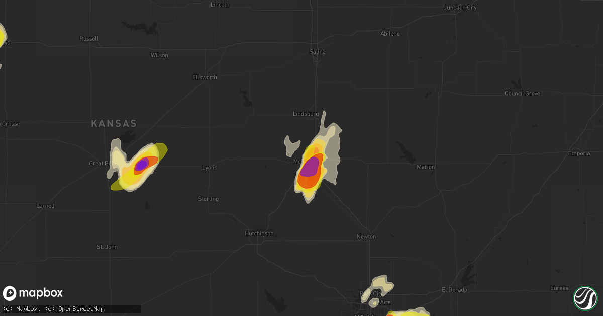
Hail Map in Mcpherson, KS on May 29, 2018
Get this storm
May 29 map
$229
one time, instant access
Download today. No call, no setup
Keep the $229
Bought the map and want the full workflow? Apply the entire $229 to a subscription within 7 days. None of it is wasted.
Every map, not just this one
This buys you this map. Subscription and you get every map we run, in the markets you choose from a few cities to whole states to nationwide. Plus real-time alerts the moment a storm fires.
Contact data
Name, contact info, occupancy, even credit band for addresses in the footprint. You go from where it hit to who to call.
Become the source they trust
Unlimited branding weather history reports on demand. You already have the documented answer ready for the property owner, and you are the one who showed up with it.
Property data and RoofTrace estimates
Pull up any address you have got, its value and the exact code rules for that jurisdiction, straight from One Click Code. Then RoofTrace estimates the squares, pitch, and roof value, priced the way you price.
Storm reports in Mcpherson, KS
Mcpherson, KS
| Date | Description |
|---|---|
| 05/29/20186:58 PM CDT | A local report indicates 1.00 inch wind near 3 S MCPHERSON |
| 05/29/20186:56 PM CDT | A local report indicates 1.75 inch wind near 6 SSE MCPHERSON |
| 05/28/20187:06 PM CDT | Golf ball to baseball size hail. |
All States Impacted by Hail Map on May 29, 2018
All Cities Impacted by Hail Map on May 29, 2018
- Freedom, OK
- Buffalo, OK
- Rosston, OK
- Grand Meadow, MN
- Dexter, MN
- Cope, CO
- Kirk, CO
- Yuma, CO
- Joes, CO
- Mooreland, OK
- Parkers Prairie, MN
- Garfield, MN
- New York Mills, MN
- Burdett, KS
- Goltry, OK
- Ensign, KS
- Dodge City, KS
- Belpre, KS
- Spearville, KS
- Offerle, KS
- Meno, OK
- Ringwood, OK
- Ostrander, MN
- Great Bend, KS
- Shamrock, TX
- Wheeler, TX
- Pampa, TX
- Miami, TX
- Mobeetie, TX
- Ness City, KS
- Hanston, KS
- Falun, KS
- Marquette, KS
- Ellsworth, KS
- Brookville, KS
- Lawton, OK
- Brownton, MN
- Ellinwood, KS
- Lorraine, KS
- Ogilvie, MN
- Onamia, MN
- Mora, MN
- Milaca, MN
- Durant, OK
- Enid, OK
- St John, KS
- Rose Creek, MN
- Echo, MN
- Vesta, MN
- Laporte, MN
- Nevis, MN
- Cass Lake, MN
- Akeley, MN
- Walker, MN
- Cawker City, KS
- Downs, KS
- Pierz, MN
- Waukomis, OK
- Covington, OK
- Fairmont, OK
- Douglas, OK
- Otho, IA
- Fort Dodge, IA
- Cimarron, KS
- Pine Island, MN
- Kasson, MN
- Hayfield, MN
- Rochester, MN
- Oronoco, MN
- Racine, MN
- Byron, MN
- Stewartville, MN
- Sebeka, MN
- Wadena, MN
- Menahga, MN
- Verndale, MN
- Lincoln, KS
- Kanopolis, KS
- Beverly, KS
- Follett, TX
- Balko, OK
- Darrouzett, TX
- Laverne, OK
- Booker, TX
- Perryton, TX
- Solway, MN
- Shevlin, MN
- Redlake, MN
- Leonard, MN
- Austin, MN
- Waltham, MN
- Waynoka, OK
- Erick, OK
- Saint Croix Falls, WI
- Hays, KS
- Ellis, KS
- Sayre, OK
- Texola, OK
- Sweetwater, OK
- Carter, OK
- Protection, KS
- Coldwater, KS
- Hutchinson, MN
- Alva, OK
- Elgin, OK
- Fort Sill, OK
- Medicine Park, OK
- Wichita, KS
- Bucklin, KS
- Minneola, KS
- Ford, KS
- Lone Wolf, OK
- Indiahoma, OK
- Cache, OK
- Roosevelt, OK
- Sentinel, OK
- Hobart, OK
- Alexandria, MN
- Sylvan Grove, KS
- Staples, MN
- Mullinville, KS
- Wright, KS
- Long Prairie, MN
- Osborne, KS
- Portis, KS
- Derby, KS
- Jetmore, KS
- Udall, KS
- Haviland, KS
- Valley Center, KS
- Manhattan, KS
- Dodge Center, MN
- West Concord, MN
- Wanamingo, MN
- Kenyon, MN
- Ingalls, KS
- Andover, KS
- Sargeant, MN
- Mantorville, MN
- Mcpherson, KS
- Catharine, KS
- Aline, OK
- Carmen, OK
- Dacoma, OK
- Greensburg, KS
- Augusta, KS
- Milroy, MN
- Lucan, MN
- Lewis, KS
- Canadian, TX
- Elk City, OK
- Venango, NE
- Limon, CO
- Delphos, KS
- Carlos, MN
- Nelson, MN
- Champion, NE
- Alton, KS
- Esbon, KS
- Plainville, KS
- Natoma, KS
- Inman, KS
- Moundridge, KS
- Galva, KS
- Glenville, MN
- Northwood, IA
- Kensett, IA
- Grant, NE
- Ogallala, NE
- Brule, NE
- Dalbo, MN
- Cambridge, MN
- Stanchfield, MN
- Princeton, MN
- Hines, OR
- Grand Rapids, MN
- Saint Paul, MN
- Walnut Grove, MN
- Wray, CO
- Haigler, NE
- Browerville, MN
- Park Rapids, MN
- Calhan, CO
- Gaylord, KS
- Albert Lea, MN
- Hollandale, MN
- Ravenna, NE
- Cheyenne, OK
- Kinsley, KS
- Macksville, KS
- Red Oak, IA
- Blooming Prairie, MN
- Beloit, KS
- Cleo Springs, OK
- Lahoma, OK
- Pequot Lakes, MN
- Pine River, MN
- Woodston, KS
- Stockton, KS
- Burlington, CO
- Renville, MN
- McCook, NE
- Indianola, NE
- Stone Lake, WI
- Birchwood, WI
- Hayward, WI
- Alamo, ND
- Osakis, MN
- Hillman, MN
- Zumbrota, MN
- Mcgregor, MN
- Burrton, KS
- Randall, MN
- Cushing, MN
- Aitkin, MN
- Palisade, MN
- Nicollet, MN
- Glencoe, MN
- Villard, MN
- Miltona, MN
- Ashland, KS
- Burtrum, MN
- Grey Eagle, MN
- Holyrood, KS
- Isanti, MN
- Saint Francis, MN
- Randolph, KS
- Logan, IA
- Mercer, MO
- Claflin, KS
- Backus, MN
- Hector, MN
- Wilmore, KS
- Claremont, MN
- Granite, OK
- Victoria, KS
- Paradise, KS
- Hutchinson, KS
- Windom, KS
- Panama, IA
- Portsmouth, IA
- Earling, IA
- Dunlap, IA
- Minneapolis, KS
- Glasco, KS
- Dow City, IA
- Boswell, OK
- Little Falls, MN
- Remer, MN
- Longville, MN
- Faribault, MN
- Noonan, ND
- Rosemount, MN
- Mendota, MN
- Inver Grove Heights, MN
- Calera, OK
- Hugo, CO
- Hackensack, MN
- Lindsborg, KS
- Assaria, KS
- Gypsum, KS
- Newton, KS
- Hillsboro, KS
- Canton, KS
- Goessel, KS
- Chase, KS
- Aldrich, MN
- Brooten, MN
- Kechi, KS
- Bokchito, OK
- Foss, OK
- Dill City, OK
- Warba, MN
- Larned, KS
- Royalton, MN
- Brandon, MN
- Cohasset, MN
- Holyoke, CO
- Brainerd, MN
- Fort Ripley, MN
- Dassel, MN
- Stewart, MN
- Crosby, ND
- South Hutchinson, KS
- Rice Lake, WI
- Babbitt, MN
- Cedar, MN
- Bethel, MN
- Wahkon, MN
- Sauk Centre, MN
- Sturgeon Lake, MN
- Kettle River, MN
- Bertha, MN
- Eagle Bend, MN
- Clarissa, MN
- Redwood Falls, MN
- Marshalltown, IA
- Mead, OK
- Kingston, OK
- Cokato, MN
- Arnegard, ND
- Glen Elder, KS
- Volborg, MT
- Powderville, MT
- Carrier, OK
- Zumbro Falls, MN
- Drummond, OK
- Kenefic, OK
- Garber, OK
- Farmington, MN
- Geneseo, KS
- Goodhue, MN
- Griswold, IA
- Helena, OK
- Alexander, KS
- Canute, OK
- Barnard, KS
- Mallard, IA
- Cherokee, OK
- Milburn, OK
- Tishomingo, OK
- Belview, MN
- Wood River, NE
- Stratton, CO
- Bethune, CO
- Villisca, IA
- Shelby, IA
- Chetek, WI
- Litchfield, MN
- Briscoe, TX
- Evansville, MN
- Solon Springs, WI
- Cordell, OK
- Towanda, KS
- Mcconnell Afb, KS
- Sterling, KS
- Bena, MN
- Tryon, NE
- Anoka, MN
- Andover, MN
- Ramah, CO
- Matheson, CO
- Rice, MN
- Bird City, KS
- Balsam Lake, WI
- Milltown, WI
- Centuria, WI
- Siren, WI
- Saint James, MN
- Pennington, MN
- Ute, IA
- Caddo, OK
- Gibbon, MN
- Wilson, KS
- Deer River, MN
- Ponemah, MN
- Clara City, MN
- Hudson, KS
- Ackley, IA
- Alden, KS
- Wakeeney, KS
- Fairmont, MN
- New Market, IA
- Clarinda, IA
- New Richland, MN
- Hartland, MN
- Frederic, WI
- Kansas City, KS
- New Auburn, MN
- Mulvane, KS
- Williston, ND
- Halstead, KS
- Wellsburg, IA
- Minden, IA
- Maple Lake, MN
- Roxbury, KS
- Peyton, CO
- Beatrice, NE
- Benton, KS
- Wildrose, ND
- Willow River, MN
- Gaylord, MN
- Anton, CO
- Neola, IA
- Akron, CO
- Geneva, IA
- Hewitt, MN
- Motley, MN
- Swanville, MN
- Rock Port, MO
- Waldo, KS
- Duluth, MN
- Elk Mound, WI
- Colfax, WI
- Chester, OK
- Mikana, WI
- Bloomer, WI
- Owatonna, MN
- Hill City, MN
- Carson, IA
- Henderson, IA
- Emerson, IA
- Elliott, IA
- Cumberland, IA
- Anita, IA
- Wiota, IA
- Montezuma, KS
- Mankato, KS
- Pawnee Rock, KS
- Simpson, KS
- Douglass, KS
- Russell, KS
- Gorham, KS
- Madrid, NE
- Mountain Park, OK
- Nash, OK
- Luck, WI
- Isle, MN
- Moose Lake, MN
- Jim Falls, WI
- Cornell, WI
- Chippewa Falls, WI
- Eau Claire, WI
- Finlayson, MN


