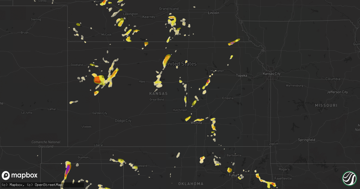
Hail Map in Kansas on May 29, 2016
Get this storm
May 29 map
$229
one time, instant access
Download today. No call, no setup
Keep the $229
Bought the map and want the full workflow? Apply the entire $229 to a subscription within 7 days. None of it is wasted.
Every map, not just this one
This buys you this map. Subscription and you get every map we run, in the markets you choose from a few cities to whole states to nationwide. Plus real-time alerts the moment a storm fires.
Contact data
Name, contact info, occupancy, even credit band for addresses in the footprint. You go from where it hit to who to call.
Become the source they trust
Unlimited branding weather history reports on demand. You already have the documented answer ready for the property owner, and you are the one who showed up with it.
Property data and RoofTrace estimates
Pull up any address you have got, its value and the exact code rules for that jurisdiction, straight from One Click Code. Then RoofTrace estimates the squares, pitch, and roof value, priced the way you price.
Storm reports in Kansas
Kansas
| Date | Description |
|---|---|
| 05/29/20166:38 PM CDT | A local report indicates 1.25 inch wind near 4 S CORNING |
| 05/29/20166:10 PM CDT | Up to quarter size hail. |
| 05/29/20165:57 PM CDT | A local report indicates 1.50 inch wind near 9 SW CONCORDIA |
| 05/29/20165:23 PM CDT | Mostly nickel size hail with some quarter size hail mixed in. Occurred at i-70 exit for levant. |
| 05/29/20165:18 PM CDT | Up to quarter size hail. Mostly pea size. |
| 05/29/20164:58 PM CDT | Up to quarter size. |
| 05/29/20164:55 PM CDT | Relayed via social media |
| 05/29/20164:45 PM CDT | Delayed report social media. A few quarter sized...mostly dimes. |
| 05/29/20164:34 PM CDT | A local report indicates 60 MPH wind near 1 W BURDEN |
| 05/29/20164:34 PM CDT | A local report indicates 1.00 inch wind near 1 W BURDEN |
| 05/29/20164:23 PM CDT | Estimated 55 mph wind |
| 05/29/20164:20 PM CDT | A local report indicates 1.50 inch wind near 10 S HARLAN COUNTY DAM |
| 05/29/20164:20 PM CDT | A local report indicates 1.00 inch wind near 5 WSW GLENDALE |
| 05/29/20164:12 PM CDT | A local report indicates 1.00 inch wind near 4 SW GLENDALE |
| 05/29/20164:10 PM CDT | Relayed via social media. |
| 05/29/20164:10 PM CDT | Ping pong to golf ball size hail. |
| 05/29/20164:08 PM CDT | Delayed report. Hail up to 2 inches reported at the rock springs 4-h center. |
| 05/29/20164:07 PM CDT | A local report indicates 1.00 inch wind near JUNCTION CITY |
| 05/29/20164:00 PM CDT | A local report indicates 1.00 inch wind near 10 S OAKLEY |
| 05/29/20163:33 PM CDT | A local report indicates 2.00 inch wind near 11 SSW JUNCTION CITY |
| 05/29/20163:30 PM CDT | A local report indicates 1.00 inch wind near 4 NE WOODBINE |
| 05/29/20163:28 PM CDT | A local report indicates 1.00 inch wind near 5 NNE WOODBINE |
| 05/29/20163:25 PM CDT | Hail up to the size of ping pong balls. Some damage to vehicles and crop fields. |
| 05/29/20163:15 PM CDT | A local report indicates 1.50 inch wind near 4 E MODOC |
| 05/29/20163:09 PM CDT | Hail covering the ground |
| 05/29/20163:05 PM CDT | Broken house windows |
| 05/29/20163:00 PM CDT | A local report indicates 1.25 inch wind near 2 NE HOPE |
| 05/29/20163:00 PM CDT | Delayed report via social media. Hail lasted 10 to 15 minutes. |
| 05/29/20162:43 PM CDT | Trained spotter reports golf ball size hail at butler state lake. Relayed via emergency management. |
| 05/29/20162:43 PM CDT | Emergency manager measured 2 inch hail and reported intense lightning that started a fire in a tree row. |
| 05/29/20162:41 PM CDT | Started at 135 pm mdt and ended at 141 pm mdt. |
| 05/29/20162:39 PM CDT | Relayed via social media. Time estimated by radar. |
| 05/29/20162:09 PM CDT | Hail is coating the ground. High winds also reported. |
| 05/29/20161:43 PM CDT | A local report indicates 1.50 inch wind near 2 W BENTON |
| 05/29/20161:30 PM CDT | Delayed report |
| 05/29/20161:28 PM CDT | A local report indicates 1.00 inch wind near 1 WNW JABARA AIRPORT |
| 05/29/20161:19 PM CDT | Majority of hailstones pea to nickel with a few quarters mixed in. |
| 05/29/201611:59 AM CDT | Picture via twitter |
| 05/29/201611:59 AM CDT | Quarter to ping pong ball size hail. |
| 05/29/201611:55 AM CDT | Picture via twitter |
| 05/28/20168:43 PM CDT | A local report indicates 1.75 inch wind near 5 S IONIA |
| 05/28/20168:27 PM CDT | Report from facebook. Estimated hail size from picture...golfball was largest in picture. |
| 05/28/20167:45 PM CDT | A local report indicates 1.00 inch wind near 1 S BUNKER HILL |
| 05/28/20167:33 PM CDT | Delayed report. Social media. |
| 05/28/20167:27 PM CDT | Delayed report. Social media. |
| 05/28/20167:07 PM CDT | A local report indicates 63 MPH wind near RUSSELL AIRPORT |
All States Impacted by Hail Map on May 29, 2016
Cities Impacted by Hail Map on May 29, 2016
- Clewiston, FL
- Lawn, TX
- Ovalo, TX
- Stilwell, OK
- Canehill, AR
- Westville, OK
- Lincoln, AR
- Llano, TX
- Hendley, NE
- Beaver City, NE
- Harrison, NE
- Crowell, TX
- Mobeetie, TX
- Canadian, TX
- Miami, TX
- Wheeler, TX
- Briscoe, TX
- Albany, TX
- Nash, OK
- Santa Anna, TX
- Abilene, TX
- Clyde, TX
- Capitan, NM
- Stinnett, TX
- Sunray, TX
- Prague, OK
- Center, KY
- Hot Springs Village, AR
- Denison, TX
- Colby, KS
- Seymour, TX
- Debary, FL
- Bard, NM
- San Jon, NM
- Turkey, TX
- New Haven, MI
- Armada, MI
- Ray, MI
- Richmond, MI
- Concordia, KS
- Glasco, KS
- Spur, TX
- Dickens, TX
- Follett, TX
- Atlanta, KS
- Latham, KS
- El Dorado, KS
- Menard, TX
- Brady, TX
- Eden, TX
- Channing, TX
- Tucumcari, NM
- Lueders, TX
- Anson, TX
- Baird, TX
- Hawley, TX
- Friona, TX
- Lovington, NM
- Ranger, TX
- Hershey, NE
- Scott City, KS
- Sumner, TX
- Brookston, TX
- Oxford, NE
- Orleans, NE
- Laverne, OK
- Plainview, TX
- Park, KS
- Quinter, KS
- Edison, NE
- Arapahoe, NE
- Avoca, TX
- Cross Plains, TX
- Sparks, OK
- Amarillo, TX
- Junction City, KS
- Munday, TX
- Goree, TX
- Throckmorton, TX
- Newcastle, TX
- Weinert, TX
- Hereford, TX
- Doniphan, NE
- Giltner, NE
- Dunning, NE
- Logan, NM
- Pep, NM
- Catoosa, OK
- Broken Arrow, OK
- Russell, KS
- Bunker Hill, KS
- Lucas, KS
- Waldo, KS
- Luray, KS
- Dorrance, KS
- Arcadia, FL
- Fairborn, OH
- Enon, OH
- Apopka, FL
- Sorrento, FL
- Oconto, NE
- Callaway, NE
- Middleburgh, NY
- Agra, KS
- Phillipsburg, KS
- Clarksville, OH
- Blanchester, OH
- Wilmington, OH
- Cambridge, KS
- Burden, KS
- North Branch, MI
- Waterford, OH
- Hope, KS
- Lincolnville, KS
- Ramona, KS
- Lost Springs, KS
- Bassett, NE
- Floyd, NM
- Sabina, OH
- New Vienna, OH
- Shamrock, TX
- Glenvil, NE
- Umpire, AR
- Langley, AR
- Hendrix, OK
- Ravenna, TX
- Mason, TX
- Brownwood, TX
- Early, TX
- Van Alstyne, TX
- Anna, TX
- Whitewright, TX
- Savoy, TX
- Bells, TX
- Talpa, TX
- Bartlett, NE
- Paris, TX
- Blossom, TX
- Eustis, FL
- Grinnell, KS
- Leon, KS
- Trumbull, NE
- Inland, NE
- Harvard, NE
- Hastings, NE
- Benkelman, NE
- Rising Star, TX
- Breckenridge, TX
- Eustis, NE
- Canton, SD
- Burr Oak, KS
- Guide Rock, NE
- Enders, NE
- Imperial, NE
- Lake Wales, FL
- Haines City, FL
- Wagner, SD
- Dante, SD
- Cedar Vale, KS
- Parks, NE
- Gove, KS
- Dawson, NE
- Stratford, TX
- Gillett, AR
- De Witt, AR
- Fairfax, OK
- Ayr, NE
- Sheridan, AR
- Redfield, AR
- Jefferson, AR
- Pampa, TX
- Burwell, NE
- Otis, CO
- Fargo, OK
- Beloit, KS
- Snyder, TX
- Marienthal, KS
- Dumas, TX
- Panhandle, TX
- Ochopee, FL
- Carbon, TX
- Comanche, TX
- Cisco, TX
- Burkett, TX
- Coleman, TX
- Gorman, TX
- Voss, TX
- Tuscola, TX
- Novice, TX
- Gouldbusk, TX
- Valera, TX
- Ballinger, TX
- Eastland, TX
- Winters, TX
- Goldsboro, TX
- Deshler, NE
- Sherrill, AR
- Elida, NM
- Gresham, NE
- Waco, NE
- Gothenburg, NE
- Cozad, NE
- Wylie, TX
- Allen, TX
- Melissa, TX
- Oakley, KS
- Monument, KS
- Winona, KS
- Masterson, TX
- San Saba, TX
- Marion, OH
- Caledonia, OH
- Seneca, KS
- Bern, KS
- Port Clinton, OH
- Claremore, OK
- Texhoma, OK
- De Leon, TX
- Valley Spring, TX
- Clarendon, TX
- Woodbine, KS
- Kennebec, SD
- Chapman, KS
- White City, KS
- Herington, KS
- Butte, NE
- Proctor, OK
- Junction, TX
- Broken Bow, NE
- Grainfield, KS
- Hazel Park, MI
- Warren, MI
- Wichita, KS
- Benton, KS
- Fort Plain, NY
- Asher, OK
- Lawrence, NE
- Deweese, NE
- Fairfield, NE
- Blue Hill, NE
- Dayton, OH
- Cawker City, KS
- Glen Elder, KS
- Palatine Bridge, NY
- Hoxie, KS
- Bokchito, OK
- Groom, TX
- Blue Ridge, TX
- Alexandria, NE
- Hamilton, TX
- Pottsville, TX
- Mullin, TX
- Goldthwaite, TX
- Priddy, TX
- Tolar, TX
- Bluff Dale, TX
- Lampasas, TX
- Sudan, TX
- Muleshoe, TX
- Haxtun, CO
- Crook, CO
- Ovid, CO
- Sedgwick, CO
- Cherokee, IA
- Olmsted Falls, OH
- Grafton, OH
- North Ridgeville, OH
- Columbia Station, OH
- Melrose, NM
- Tahlequah, OK
- Hobbs, NM
- Westerville, NE
- Comstock, NE
- Ansley, NE
- Halsey, NE
- Arnold, NE
- Stapleton, NE
- Tipton, KS
- Borger, TX
- Adrian, TX
- Labelle, FL
- Skiatook, OK
- Sand Springs, OK
- Prue, OK
- Hartley, TX
- Dalhart, TX
- Woodward, OK
- Las Vegas, NM
- Saint Regis Falls, NY
- Colton, NY
- Plano, TX
- Richardson, TX
- Lohn, TX
- Doole, TX
- Millersview, TX
- North Platte, NE
- Richland Springs, TX
- Grafton, NE
- Sutton, NE
- Skellytown, TX
- Stockbridge, MA
- Kechi, KS
- Greenwich, KS
- Selden, KS
- Paducah, TX
- Saint Cloud, FL
- Kenansville, FL
- Manhattan, KS
- Sycamore, OH
- Galion, OH
- Crestline, OH
- Tiro, OH
- Bucyrus, OH
- Nevada, OH
- Pryor, OK
- Champion, NE
- Childress, TX
- Charlotte, TX
- Pearsall, TX
- Jourdanton, TX
- Cotulla, TX
- Tilden, TX
- Calliham, TX
- Cleveland, AR
- Hattieville, AR
- Syracuse, KS
- Oneida, NY
- Shickley, NE
- Geneva, NE
- Strang, NE
- Mckinney, TX
- McDonald, KS
- Bird City, KS
- Salt Flat, TX
- Mabelvale, AR
- Little Rock, AR
- Hensley, AR
- Haskell, TX
- Gruver, TX
- White Deer, TX
- Loxahatchee, FL
- Rochelle, TX
- Brookesmith, TX
- Evansville, AR
- Downs, KS
- Lometa, TX
- Locust Grove, OK
- Hulbert, OK
- Peggs, OK
- Springfield, OH
- Yellow Springs, OH
- Tipp City, OH
- Johnstown, NY
- Kimball, SD
- Pukwana, SD
- Castell, TX
- Bronte, TX
- Ferris, TX
- Seagoville, TX
- Ennis, TX
- Mount Pleasant, TX
- Talco, TX
- Parishville, NY
- Edison, OH
- Neligh, NE
- Tilden, NE
- Moorefield, NE
- Adirondack, NY
- Pottersville, NY
- Earth, TX
- Hermleigh, TX
- Hebron, NE
- Bonham, TX
- Celina, TX
- Doss, TX
- Harper, TX
- Fredericksburg, TX
- Kissimmee, FL
- Cee Vee, TX
- Matador, TX
- Swanton, VT
- Palisade, NE
- Reliance, SD
- Lower Brule, SD
- Carlsbad, NM
- Vici, OK
- Sutherland, NE
- Dublin, TX
- Lewisport, KY
- Towanda, KS
- Olney, TX
- Rockwall, TX
- Oakland City, IN
- Francisco, IN
- Fort Branch, IN
- East China, MI
- Claude, TX
- Blanket, TX
- Hoisington, KS
- Lonsdale, AR
- Cutler, OH
- Dexter, KS
- Ponca City, OK
- Red Rock, OK
- Marland, OK
- Antlers, OK
- Oak, NE
- Nelson, NE
- Edgar, NE
- Balko, OK
- Lehigh, KS
- Durham, KS
- Brown City, MI
- Melvin, MI
- West Bloomfield, MI
- Walled Lake, MI
- Novi, MI
- Inman, KS
- Mcpherson, KS
- Clovis, NM
- Fritch, TX
- Tulsa, OK
- Knox City, TX
- Avon, SD
- Rotan, TX
- Verona, NY
- Corning, KS
- Erick, OK
- South Charleston, OH
- London, OH
- Fort Riley, KS
- Maxwell, NE
- Brady, NE
- Brookville, KS
- Lipan, TX
- Cherokee, TX
- Pontotoc, TX
- Esbon, KS
- Shattuck, OK
- Beaver, OK
- Bertrand, NE
- Quitaque, TX
- Lakeview, TX
- Trenton, TX
- Leonard, TX
- Baileyville, KS
- Andale, KS
- Mount Hope, KS
- Clay Center, NE
- Girard, TX
- Jayton, TX
- Clearwater, NE
- Elgin, NE
- Oakdale, NE
- Ewing, NE
- Ainsworth, NE
- Otwell, IN
- Sidney, NE
- Potter, NE
- May, TX
- Stephenville, TX
- Sanford, FL
- Lake Mary, FL
- Longwood, FL
- Bunch, OK
- Morrow, AR
- Mertzon, TX
- Centerville, SD
- Rogers, NM
- Housatonic, MA
- Great Barrington, MA
- West Stockbridge, MA
- Lee, MA
- Saint Clair, MI
- Schroon Lake, NY
- Lake Placid, FL
- Croswell, MI
- Stamford, TX
- Caddo Gap, AR
- Colwich, KS
- Hillsboro, KS
- Sheffield Lake, OH
- Avon Lake, OH
- Tribune, KS
- Mud Butte, SD
- Union Center, SD
- Elwood, NE
- Montpelier, ID
- Immokalee, FL
- Fairfax, SD
- Spencer, NE
- Summersville, KY
- Magnolia, KY
- Johnstown, NE
- Palm Bay, FL
- Geneseo, NY
- Lima, NY
- Avon, NY
- Livonia, NY
- Lakeville, NY
- Norman, AR
- Taylor, NE
- Davisburg, MI
- Wallace, KS
- Wood Lake, NE
- Fowlerton, TX
- Preston, ID
- Rose, OK
- Holly, CO
- Rapid City, SD
- Shidler, OK
- Eckley, CO
- Onaga, KS
- Moundridge, KS
- Goessel, KS
- Canton, KS
- Oberlin, KS
- Anselmo, NE
- Sargent, NE
- Brewster, NE
- Campbellton, TX
- Rosalia, KS
- Altamonte Springs, FL
- Orlando, FL
- Pecos, TX
- Dix, NE
- Gustine, TX
- Bend, TX
- Benton, AR
- Washington, MI
- Okeene, OK
- Lindsborg, KS
- Salina, KS
- Evansville, IN
- O'Brien, TX
- Barnsdall, OK
- Pawhuska, OK
- Au Sable Forks, NY
- Saranac, NY
- Tampa, KS
- Belpre, OH
- Little Hocking, OH
- Washington, WV
- Parkersburg, WV
- Bangs, TX
- Farnam, NE
- Miami, FL
- Lithonia, GA
- Conyers, GA
- Monticello, AR
- Roswell, NM
- Mingus, TX
- Desdemona, TX
- Meriden, IA
- Bartlesville, OK
- Newport, NE
- Stuart, NE
- Detroit, TX
- Petersburg, MI
- Sonora, TX
- Boswell, OK
- Atoka, OK
- Cedar Rapids, NE
- Mankato, KS
- Fairview, SD
- Hudson, SD
- Jewell, KS
- Lancaster, TX
- Salem, NE
- Brooksville, FL
- Spring Hill, FL
- Oskaloosa, IA
- Lake Arthur, NM
- Limon, CO
- Niobrara, NE
- Isabella, OK
- Midland, OH
- Martinsville, OH
- Rochester, TX
- Moore, TX
- Causey, NM
- Greenfield, IN
- Schuyler Falls, NY
- Vermontville, NY
- Winfield, KS
- Lapeer, MI
- Columbiaville, MI
- Hardyville, KY
- Edmonton, KY
- Sharon, OK
- Boles, AR
- Cardington, OH
- Mount Gilead, OH
- Leoti, KS
- Vega, TX
- Parks, AR
- Foreman, AR
- Humphrey, AR
- Rock Valley, IA
- Ubly, MI
- Lagrange, OH
- Elyria, OH
- Beverly, KS
- Agate, CO
- Newhope, AR
- Tyndall, SD
- Lynch, NE
- Mount Ida, AR
- Lambertville, MI
- Temperance, MI
- Riley, KS
- Celeste, TX
- Farmersville, TX
- Long Pine, NE
- Springview, NE
- Rattan, OK
- Finley, OK
- Vivian, SD
- Superior, NE
- Primrose, NE
- Wolbach, NE
- Belgrade, NE
- Palmer, NE
- Fullerton, NE
- White Hall, AR
- Providence, KY
- Dixon, KY
- Springfield, CO
- Hunter, KS
- Osborne, KS
- Avon, OH
- Wilmer, TX
- Mena, AR
- Sedgwick, KS
- Halstead, KS
- Harbor Beach, MI
- Filion, MI
- Bad Axe, MI
- Port Hope, MI
- England, AR
- Lynnville, IN
- Elberfeld, IN
- Romeo, MI
- Put In Bay, OH
- Cheney, KS
- Sidney, TX
- Saint Johnsville, NY
- Umatilla, FL
- Fremont, OH
- Holbrook, NE
- Cambridge, NE
- Continental, OH
- Defiance, OH
- Bloomfield, NE
- Garden Plain, KS
- Ramona, OK
- Morse, TX
- Allenton, MI
- Croghan, NY
- Larrabee, IA
- Scurry, TX
- Stockville, NE
- Hesston, KS
- Gould, AR
- Fredericktown, OH
- Bauxite, AR
- Alexander, AR
- Bryant, AR
- Hot Springs National Park, AR
- Colbert, OK
- Beresford, SD
- Memphis, MI
- Leonard, MI
- Almont, MI
- Cedarville, OH
- Mountain Pine, AR
- Applegate, MI
- Carsonville, MI
- Elizabeth, CO
- Prairie Grove, AR
- Watonga, OK
- Fort Thompson, SD
- Chappell, NE
- Saronville, NE
- Munnsville, NY
- Childwold, NY
- Naper, NE
- Grandview, IN
- Zephyr, TX
- Bagwell, TX
- Springfield, SD
- Benjamin, TX
- Tell, TX
- Fonda, NY
- Goff, KS
- Havensville, KS
- Lewellen, NE
- Mount Dora, FL
- North Street, MI
- Ericson, NE
- Smithville, OK
- Salina, OK
- Clifford, MI
- Silverwood, MI
- Roaring Springs, TX
- Hope, NM
- Stone Mountain, GA
- Snellville, GA
- Levant, KS
- Skaneateles, NY
- Rockport, IN
- Andover, KS
- Utica, MI
- Harvey, IA
- Lyons, CO
- Marine City, MI
- Wynona, OK
- Hominy, OK
- Rison, AR
- Falun, KS
- Clarksville, TX
- Moore Haven, FL
- Tescott, KS
- Honey Grove, TX
- Fredonia, TX
- Paron, AR
- Norwalk, OH
- Pine Bluff, AR
- Mount Sterling, OH
- Columbus, MI
- Meno, OK
- Haworth, OK
- Hull, IA
- Star City, AR
- Norton, KS
- Mansfield, OH
- Garvin, OK
- Moran, TX
- Wilsonville, NE
- Morganfield, KY
- Chester, OK
- Nelliston, NY
- Ward, CO
- Palmer, TX
- Melbourne, FL
- Macomb, MI
- Kim, CO
- Syracuse, NY
- Lacarne, OH
- Oak Harbor, OH
- Grapevine, AR
- Wakita, OK
- Dallas, TX
- Bellville, OH
- Orange City, IA
- Naponee, NE
- Morgantown, IN
- Leesburg, OH
- Clayton, NM
- Jessieville, AR
- Gypsum, KS
- Lexington, MI
- Port Sanilac, MI
- Old Glory, TX
- Petty, TX
- Roxton, TX
- Lewisville, AR
- Dimmitt, TX
- South Solon, OH
- Lindsey, OH
- Marcellus, NY
- Oxford, MI
- Santo, TX
- Sebring, FL
- Keego Harbor, MI
- Geneva, ID
- Indianapolis, IN
- Sperry, OK
- Haven, KS
- Humboldt, NE
- Du Bois, NE
- Soldier, KS
- Kensington, KS
- Ong, NE
- Willow Island, NE


