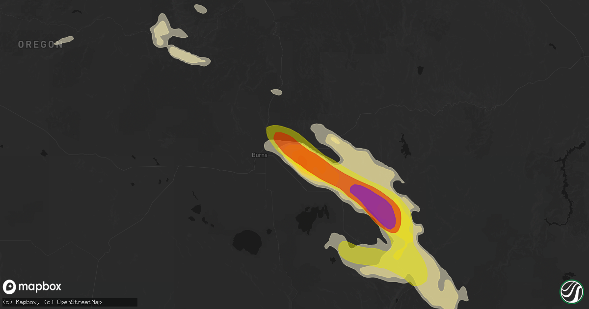
Hail Map in Burns, OR on May 28, 2026
Get this storm
May 28 map
$229
one time, instant access
Download today. No call, no setup
Keep the $229
Bought the map and want the full workflow? Apply the entire $229 to a subscription within 7 days. None of it is wasted.
Every map, not just this one
This buys you this map. Subscription and you get every map we run, in the markets you choose from a few cities to whole states to nationwide. Plus real-time alerts the moment a storm fires.
Contact data
Name, contact info, occupancy, even credit band for addresses in the footprint. You go from where it hit to who to call.
Become the source they trust
Unlimited branding weather history reports on demand. You already have the documented answer ready for the property owner, and you are the one who showed up with it.
Property data and RoofTrace estimates
Pull up any address you have got, its value and the exact code rules for that jurisdiction, straight from One Click Code. Then RoofTrace estimates the squares, pitch, and roof value, priced the way you price.
Storm reports in Burns, OR
Burns, OR
| Date | Description |
|---|---|
| 05/28/20264:53 PM CDT | Asos station kbno burns. |
| 05/28/20264:36 PM CDT | ***delayed report*** reported ping pong ball size hail east of burns. Exact timing estimated from radar. |
| 05/28/20264:34 PM CDT | Mesonet station od152 2.6 ne burns |
All States Impacted by Hail Map on May 28, 2026
All Cities Impacted by Hail Map on May 28, 2026
- Jacksboro, TX
- Bridgeport, TX
- Felda, FL
- Jordan Valley, OR
- Paradise, TX
- Santo, TX
- Springtown, TX
- Poolville, TX
- Perrin, TX
- Weatherford, TX
- Riverside, OR
- Gordon, TX
- Burns, OR
- Albany, TX
- Princeton, OR
- Lipan, TX
- Stephenville, TX
- Capitan, NM
- Crane, OR
- Mescalero, NM
- Azle, TX
- Bluff Dale, TX
- Breckenridge, TX
- Weston, CO
- Aledo, TX
- Neihart, MT
- Strawn, TX
- Council, ID
- Mccall, ID
- Aguilar, CO
- Whitt, TX
- Millsap, TX
- Seneca, OR
- Baird, TX
- Cresson, TX
- Lucile, ID
- Cambridge, ID
- Carbon, TX
- Gorman, TX
- White Bird, ID
- Naches, WA
- Trinidad, CO
- Ranger, TX
- Granbury, TX
- Godley, TX
- Richland, OR
- Canyon City, OR
- Cottonwood, ID
- Big Sandy, MT
- John Day, OR
- Cut Bank, MT
- Dublin, TX
- Baker City, OR
- Haines, OR
- Union, OR
- Prineville, OR
- Mount Vernon, OR
- Pilot Rock, OR
- Mitchell, OR
- Stanford, MT
- Moccasin, MT
- Folsom, NM
- Kalispell, MT
- Jefferson, CO
- Clinton, MT
- Long Creek, OR
- Monument, OR
- Babb, MT
- Stamford, TX
- Whitlash, MT
- Trinchera, CO
- Fernwood, ID
- Saint Maries, ID
- Kimberly, OR
- Anson, TX
- Galata, MT
- Bailey, CO
- Grant, CO
- Stites, ID
- Kooskia, ID
- Stanley, NM
- Kamiah, ID
- Grangeville, ID
- Grenville, NM
- Chester, MT
- Orofino, ID
- Fossil, OR
- Wallace, ID
- Weippe, ID
- Ione, OR
- Heppner, OR
- Pierce, ID
- Browning, MT
- Condon, OR
- Deary, ID
- Rule, TX
- Santa Fe, NM
- Haskell, TX
- Shelby, MT
- Drummond, MT
- Model, CO
- Desmet, ID
- Buffalo, MT
- Potlatch, ID
- Bovill, ID
- Bonner, MT
- Elk River, ID
- Boardman, OR
- Tensed, ID
- Toston, MT
- Fairfield, WA
- Latah, WA
- Odessa, WA
- Tekoa, WA
- Pasco, WA
- Weinert, TX
- Prescott, WA
- Plummer, ID
- Arlington, OR
- Prosser, WA
- Bickleton, WA
- Donnelly, ID
- Ritzville, WA
- Valleyford, WA
- Spangle, WA
- Eltopia, WA
- Wilbur, WA
- Mabton, WA
- Mesa, WA
- Connell, WA
- Richland, WA
- Goldendale, WA
- Sagle, ID
- Kingston, ID
- Othello, WA
- Moses Lake, WA
- Sandpoint, ID
- Marlin, WA
- Harrington, WA
- Des Moines, NM
- Warden, WA
- Soap Lake, WA
- Ephrata, WA
- Choteau, MT
- Fairfield, MT


