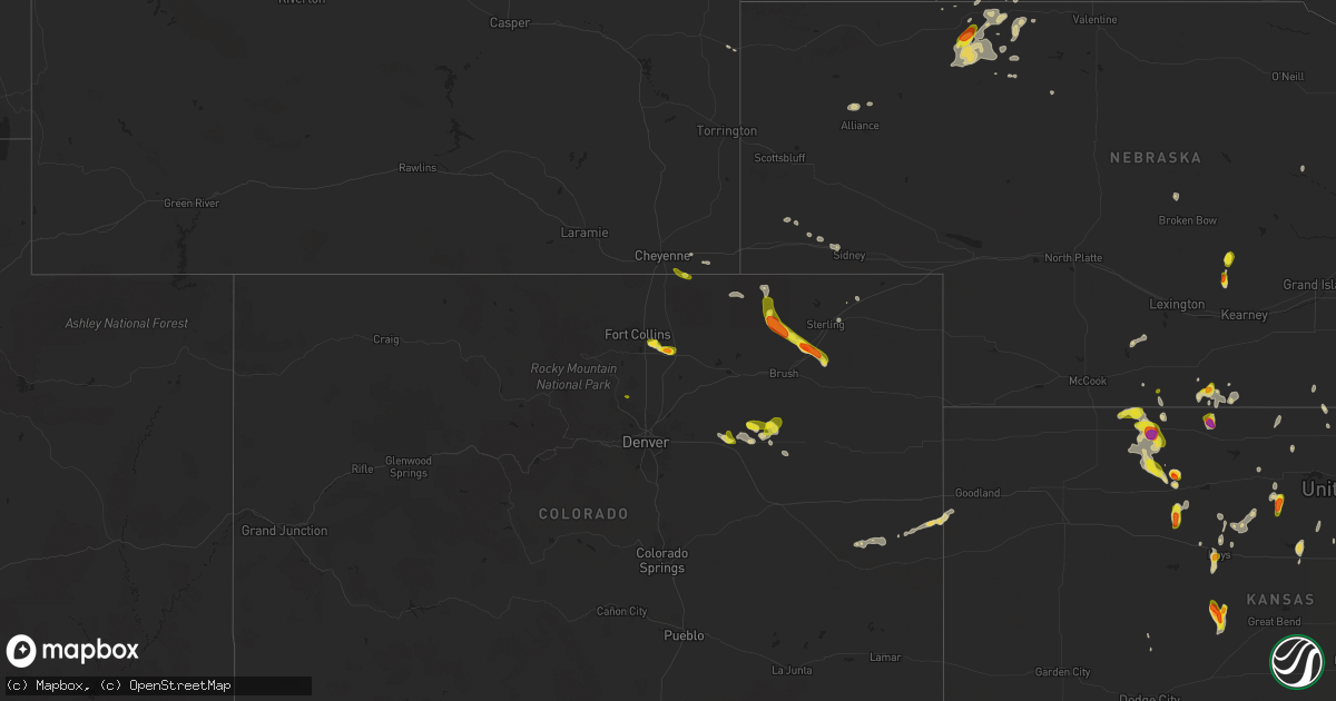
Hail Map on May 28, 2023
Get this storm
May 28 map
$229
one time, instant access
Download today. No call, no setup
Keep the $229
Bought the map and want the full workflow? Apply the entire $229 to a subscription within 7 days. None of it is wasted.
Every map, not just this one
This buys you this map. Subscription and you get every map we run, in the markets you choose from a few cities to whole states to nationwide. Plus real-time alerts the moment a storm fires.
Contact data
Name, contact info, occupancy, even credit band for addresses in the footprint. You go from where it hit to who to call.
Become the source they trust
Unlimited branding weather history reports on demand. You already have the documented answer ready for the property owner, and you are the one who showed up with it.
Property data and RoofTrace estimates
Pull up any address you have got, its value and the exact code rules for that jurisdiction, straight from One Click Code. Then RoofTrace estimates the squares, pitch, and roof value, priced the way you price.
States Impacted by Hail Map on May 28, 2023
Storm reports
Colorado
| Date | Description |
|---|---|
| 05/28/20236:15 PM CDT | A local report indicates 1.00 inch wind near 1 N STONEHAM |
| 05/28/20235:23 PM CDT | A local report indicates 1.25 inch wind near 2 NNW GARDEN CITY |
| 05/28/20235:18 PM CDT | Corrects previous hail report from 1 wnw greeley. |
| 05/28/20235:10 PM CDT | A local report indicates 1.25 inch wind near GREELEY |
| 05/28/20235:04 PM CDT | A local report indicates 1.25 inch wind near 1 WNW GREELEY |
| 05/28/20234:33 PM CDT | A local report indicates 1.00 inch wind near 2 WSW WINDSOR |
| 05/28/20234:18 PM CDT | A local report indicates 1.00 inch wind near 3 S NIWOT |
| 05/28/20234:18 PM CDT | A local report indicates 1.00 inch wind near 3 SSW NIWOT |
| 05/27/20237:18 PM CDT | Spotter reported 3 to 4 inches of plowable hail on highway 6. |
| 05/27/20237:05 PM CDT | A local report indicates 1.00 inch wind near 2 SW MERINO |
Texas
| Date | Description |
|---|---|
| 05/28/20236:58 PM CDT | West texas mesonet peak gust. Initial severe gust was at 6:48 pm with occasional severe gusts through 7:07 pm. |
| 05/28/20236:50 PM CDT | . |
| 05/28/20236:50 PM CDT | A local report indicates 1.25 inch wind near 14 WSW GRUVER |
| 05/28/20236:48 PM CDT | Report from mping: hen egg |
| 05/28/20236:44 PM CDT | Off-duty nws employee reports estimated hen egg hail falling at this moment. |
| 05/28/20236:05 PM CDT | Chaser reports several different hail sizes from golf ball to tennis ball sized hail. |
| 05/28/20236:04 PM CDT | Quarter to golf ball sized hail reported by the silverton vfd. |
| 05/28/20235:49 PM CDT | Report from mping: hen egg |
| 05/28/20235:44 PM CDT | Dimes to quarter size hail coating us 62/180 across state line in tx. |
| 05/28/20235:23 PM CDT | A local report indicates 1.75 inch wind near MORSE |
| 05/28/20235:23 PM CDT | . |
| 05/28/20235:12 PM CDT | Hansford county sheriffs office. |
| 05/28/20235:05 PM CDT | Hail ranging from quarters to golf balls. |
| 05/28/20234:06 PM CDT | . |
| 05/28/20234:06 PM CDT | A local report indicates 2.00 inch wind near 3 SSE MORSE |
| 05/28/20233:56 PM CDT | Report from mping: quarter |
| 05/28/20233:52 PM CDT | Time estimated by radar. |
| 05/27/20239:16 PM CDT | A local report indicates 70 MPH wind near 9 NNE SUNRAY |
| 05/27/20238:44 PM CDT | Peak wind gust from the west texas mesonet. Initial severe gust was at 8:38 pm. |
| 05/27/20238:12 PM CDT | West texas mesonet. |
| 05/27/20237:48 PM CDT | Corrects previous tornado report from 12 nne cactus. Tornado on the ground from roughly 7:48 pm to 7:56 pm. Confirmed touchdown and persistence confirmed via local medi |
| 05/27/20237:48 PM CDT | Tornado on the ground from roughly 7:48 pm to 7:56 pm. Confirmed touchdown and persistence confirmed via local media/livestream... Tornado lift confirmed by off-duty nw |
| 05/27/20237:13 PM CDT | A local report indicates 1.50 inch wind near 14 SSE TEXHOMA |
| 05/27/20237:13 PM CDT | . |
Kansas
| Date | Description |
|---|---|
| 05/28/20236:44 PM CDT | A local report indicates 1.00 inch wind near FETERITA |
| 05/28/20236:44 PM CDT | A local report indicates 70 MPH wind near FETERITA |
| 05/28/20236:29 PM CDT | A local report indicates 1.00 inch wind near 1 WSW HAYS |
| 05/28/20236:29 PM CDT | A local report indicates 1.75 inch wind near 3 WSW RUSH CENTER |
| 05/28/20232:19 PM CDT | Reported as ping pong ball sized hail. Delayed report from earlier. Time estimated from matched radar. |
| 05/28/20232:19 PM CDT | A local report indicates 1.00 inch wind near 2 ESE RUSH CENTER |
| 05/27/20238:07 PM CDT | Spotter reported a mix of hail from pea to a few quarters in size. Multiple reports of hail accumulating around 3 to 6 inches on roadways. |
| 05/27/20238:05 PM CDT | Relayed report of hail up to golf ball in size. Time estimated from radar. |
| 05/27/20238:02 PM CDT | Relayed report of ping pong ball size hail falling. |
Nebraska
| Date | Description |
|---|---|
| 05/28/20235:47 PM CDT | Hail up to quarter size reported on hwy 89 east of hendley. |
| 05/28/20235:25 PM CDT | Report via twitter. |
| 05/27/20237:48 PM CDT | A local report indicates 1.00 inch wind near ORLEANS |
| 05/27/20237:40 PM CDT | Hail just smaller than golf ball size reported. |
Oklahoma
| Date | Description |
|---|---|
| 05/28/20236:56 PM CDT | Report from mping. |
| 05/28/20236:40 PM CDT | A local report indicates 2.50 inch wind near 1/2 S BOYD |
| 05/28/20236:40 PM CDT | Hail up to tennis balls have been falling for at least the last 25 minutes. |
| 05/28/20236:36 PM CDT | Report from mping. |
| 05/28/20235:56 PM CDT | Report from mping: golf ball |
| 05/28/20235:44 PM CDT | . |
| 05/28/20235:44 PM CDT | A local report indicates 2.50 inch wind near 1 SSW BOYD |
| 05/28/20234:25 PM CDT | Report from mping: golf ball |
| 05/28/20233:41 PM CDT | Report from mping: golf ball |
| 05/28/20233:36 PM CDT | . |
| 05/28/20233:36 PM CDT | A local report indicates 2.00 inch wind near 7 N BALKO |
| 05/28/20233:30 PM CDT | A local report indicates 1.00 inch wind near 4 N BALKO |
| 05/28/20233:30 PM CDT | Corrects previous hail report from 4 n balko. |
Cities Impacted by Hail Map on May 28, 2023
- Turpin, OK
- Beaver, OK
- Rush Center, KS
- Kaycee, WY
- Bison, KS
- La Crosse, KS
- Morse, TX
- Stinnett, TX
- Tulia, TX
- Timnath, CO
- Windsor, CO
- Fort Collins, CO
- Greeley, CO
- Longmont, CO
- Balko, OK
- Waldo, KS
- Luray, KS
- Osborne, KS
- Norcatur, KS
- Norton, KS
- Orleans, NE
- Alma, NE
- Spearman, TX
- Larned, KS
- Ellis, KS
- Ogallah, KS
- Hill City, KS
- Palco, KS
- Salt Flat, TX
- Tatum, NM
- Plains, TX
- Hendley, NE
- Beaver City, NE
- Nekoma, KS
- New Raymer, CO
- Stoneham, CO
- Lovington, NM
- Hays, KS
- Plainville, KS
- Gaylord, KS
- Anselmo, NE
- Merna, NE
- Fort Davis, TX
- Burns, WY
- Wilsonville, NE
- Happy, TX
- Buffalo Gap, SD
- Fairburn, SD
- Smith Center, KS
- Eustis, NE
- Keystone, SD
- Natoma, KS
- Upton, WY
- Lebanon, KS
- Newcastle, WY
- Catharine, KS
- Victoria, KS
- Allen, SD
- Tuthill, SD
- Carpenter, WY
- Plains, KS
- Meade, KS
- Sylvan Grove, KS
- Dorrance, KS
- Gillette, WY
- Midwest, WY
- Dix, NE
- Fort Stockton, TX
- Alton, KS
- Kress, TX
- Silverton, TX
- Oberlin, KS
- Mason City, NE
- Litchfield, NE
- Hazard, NE
- Hugoton, KS
- Rolla, KS
- Merino, CO
- Snyder, CO
- Cheyenne, WY
- Denver City, TX
- Nunn, CO
- Grover, CO
- Woodrow, CO
- Deer Trail, CO
- Fort Morgan, CO
- Hooker, OK
- Buffalo, OK
- Elida, NM
- Akron, CO
- Merriman, NE
- Gruver, TX
- Stratford, TX
- Byers, CO
- Amherst, NE
- Sunray, TX
- Portales, NM
- Clovis, NM
- Grady, NM
- Broadview, NM
- Lockney, TX
- Bogue, KS
- Turkey, TX
- Lenora, KS
- Phillipsburg, KS
- Matador, TX
- Quitaque, TX
- Wolfforth, TX
- Ropesville, TX
- Dalhart, TX
- Dumas, TX
- Cactus, TX
- Hartley, TX
- Perryton, TX
- Wounded Knee, SD
- Martin, SD
- Lubbock, TX
- Roswell, NM
- Edgemont, SD
- Iliff, CO
- Wilson, KS
- Alliance, NE
- Porcupine, SD
- Midland, TX
- Stanton, TX
- Jal, NM
- Potter, NE
- Spalding, NE
- Hobbs, NM
- Guymon, OK
- Cannon Afb, NM
- Andrews, TX
- Red Cloud, NE
- Guide Rock, NE
- Texhoma, OK
- Goodwell, OK
- Oelrichs, SD
- Kyle, SD
- Morland, KS
- Lucas, KS
- Boise City, OK
- Felt, OK
- Okaton, SD
- Murdo, SD
- Turtle Lake, ND
- Buffalo, SD
- Otter, MT
- Scenic, SD
- Cody, NE
- Republican City, NE
- Stamford, NE
- Burr Oak, KS
- Clayton, KS
- Jennings, KS
- Naponee, NE
- Lincoln, KS
- Sidney, NE
- Mankato, KS
- Paradise, KS
- Meadow, TX
- Seagraves, TX
- Seminole, TX
- Crook, CO
- Souris, ND
- Flomot, TX
- Harrisburg, NE
- Eunice, NM
- Floydada, TX
- Earth, TX
- Sudan, TX
- Dickens, TX
- Kanorado, KS
- Burlington, CO
- Vega, TX
- Kit Carson, CO
- Amherst, TX
- Valentine, NE
- Cheyenne Wells, CO
- Ralls, TX
- Lorenzo, TX
- Muleshoe, TX
- Slaton, TX
- Rozel, KS
- Tuscola, TX
- Rosston, OK
- Gorham, KS
- Walsh, CO
- Harper, KS