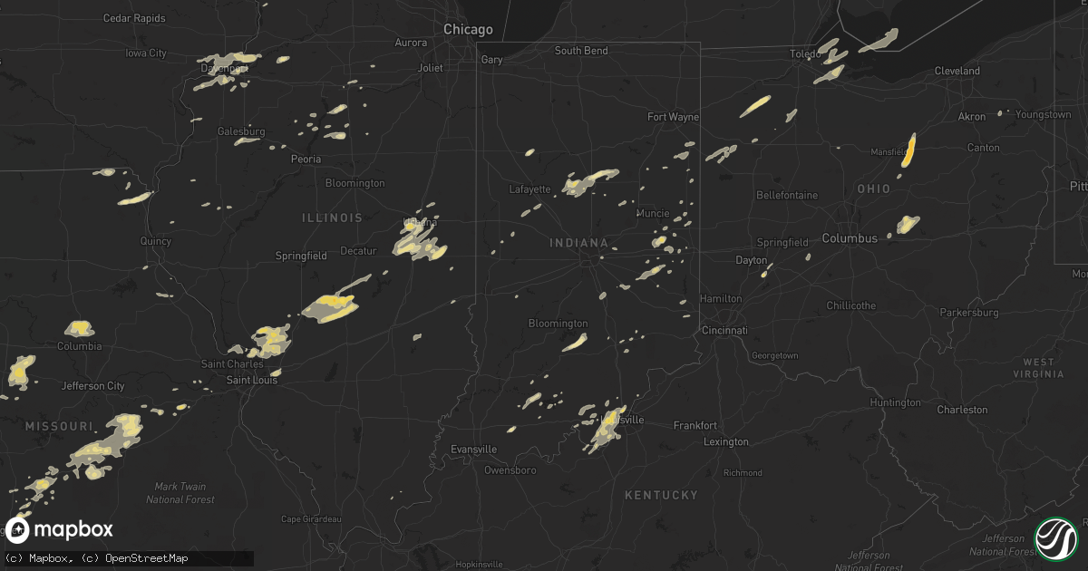
Hail Map in Illinois on May 28, 2012
Get this storm
May 28 map
$229
one time, instant access
Download today. No call, no setup
Keep the $229
Bought the map and want the full workflow? Apply the entire $229 to a subscription within 7 days. None of it is wasted.
Every map, not just this one
This buys you this map. Subscription and you get every map we run, in the markets you choose from a few cities to whole states to nationwide. Plus real-time alerts the moment a storm fires.
Contact data
Name, contact info, occupancy, even credit band for addresses in the footprint. You go from where it hit to who to call.
Become the source they trust
Unlimited branding weather history reports on demand. You already have the documented answer ready for the property owner, and you are the one who showed up with it.
Property data and RoofTrace estimates
Pull up any address you have got, its value and the exact code rules for that jurisdiction, straight from One Click Code. Then RoofTrace estimates the squares, pitch, and roof value, priced the way you price.
Storm reports in Illinois
Illinois
| Date | Description |
|---|---|
| 05/28/20125:38 PM CDT | 4 foot diameter tree down. Estimated wind speed 70 mph. |
| 05/28/20125:38 PM CDT | Law enforcement reports several blocks of lots of trees down in port byron. |
| 05/28/20122:29 AM CDT | A local report indicates 1.00 inch wind near OCONEE |
| 05/28/20121:32 AM CDT | A local report indicates 1.50 inch wind near ROSAMOND |
| 05/28/20121:25 AM CDT | A local report indicates 1.00 inch wind near ROSAMOND |
| 05/28/20121:07 AM CDT | A local report indicates 1.00 inch wind near WOOD RIVER |
| 05/28/201212:50 AM CDT | Observation from downtown |
| 05/28/201212:38 AM CDT | A local report indicates 1.00 inch wind near DORCHESTER |
| 05/27/20129:35 PM CDT | 6 inch diamter limbs down just north of bushnell. Pea size hail also occurred. |
| 05/27/20127:39 PM CDT | 7 inch diameter tree trunk snapped off about 12 feet above ground. Also saw pea to dime hail around time of damging microburt wind gust. |
| 05/27/20127:35 PM CDT | Barn destroyed...resulting in a number of cattle killed. Time associated with a microburst that was observed by nws employee. Delayed report. |
All States Impacted by Hail Map on May 28, 2012
Cities Impacted by Hail Map on May 28, 2012
- Dixon, MO
- Seymour, TX
- Jasper, IN
- Dubois, IN
- French Lick, IN
- New Albany, IN
- Georgetown, IN
- Brandenburg, KY
- Elizabeth, IN
- Louisville, KY
- Jeffersonville, IN
- Lanesville, IN
- Laconia, IN
- Corydon, IN
- Charlestown, IN
- Fairdale, KY
- Sellersburg, IN
- Floyds Knobs, IN
- Clarksville, IN
- New Middletown, IN
- Ekron, KY
- Paducah, TX
- Haskell, OK
- Okarche, OK
- Barnum, MN
- Wrenshall, MN
- Holyoke, MN
- Blanchard, OK
- Hollis Center, ME
- Scarborough, ME
- Gorham, ME
- Saco, ME
- Buxton, ME
- Coyle, OK
- Perkins, OK
- Meridian, OK
- Bunker Hill, IL
- Irasburg, VT
- Tampico, IL
- Prophetstown, IL
- Ripley, MS
- Union, MO
- Beaufort, MO
- Saint Clair, MO
- Muenster, TX
- Channing, MI
- Norman, OK
- Mcloud, OK
- Shawnee, OK
- Newalla, OK
- Taylor Ridge, IL
- Illinois City, IL
- Aitkin, MN
- Deerwood, MN
- Solon Springs, WI
- Pawhuska, OK
- Roscoe, TX
- Hermleigh, TX
- Sweetwater, TX
- Jackson, WI
- Richfield, WI
- Germantown, WI
- Hartford, WI
- Cedarburg, WI
- Grafton, WI
- Hubertus, WI
- Mequon, WI
- Colgate, WI
- Colorado City, TX
- Big Spring, TX
- Loraine, TX
- Westbrook, TX
- Coahoma, TX
- El Reno, OK
- Belle, MO
- Markesan, WI
- Reedsburg, WI
- Lyndon Station, WI
- Dalton, WI
- Marquette, WI
- Portage, WI
- Briggsville, WI
- Endeavor, WI
- Oxford, WI
- Princeton, WI
- Pardeeville, WI
- Montello, WI
- Wisconsin Dells, WI
- Baraboo, WI
- Siloam Springs, AR
- Watts, OK
- Colcord, OK
- Pana, IL
- Rosamond, IL
- Kansas, OK
- Reynolds, IN
- Montpelier, VT
- Lawton, OK
- Talala, OK
- Nowata, OK
- Roxbury, VT
- Randolph, VT
- Brookfield, VT
- Granville, VT
- Leroy, MI
- East Moline, IL
- Moline, IL
- Silvis, IL
- Carbon Cliff, IL
- Colona, IL
- Hillsdale, IL
- Asbury, MO
- Rumney, NH
- Canaan, NH
- Rushville, IN
- Glenwood, IN
- Carthage, MO
- Princeton, KY
- Albany, MN
- Cold Spring, MN
- Freeport, MN
- Richmond, MN
- Rice, MN
- Saint Martin, MN
- Foreston, MN
- Foley, MN
- Sauk Rapids, MN
- Saint Joseph, MN
- Sartell, MN
- Avon, MN
- Paynesville, MN
- Oak Park, MN
- Crowell, TX
- Woodstock, VT
- Bethel, VT
- Sharon, VT
- Stockbridge, VT
- West Hartford, VT
- South Royalton, VT
- North Pomfret, VT
- South Pomfret, VT
- Wellston, OK
- Mulhall, OK
- Guthrie, OK
- Stroud, OK
- Carney, OK
- Davenport, OK
- Stillwater, OK
- Chandler, OK
- Okmulgee, OK
- Rapid River, MI
- Nahma, MI
- Lebanon, OK
- Madill, OK
- Marietta, OK
- Snyder, TX
- Pilot Grove, MO
- Lowry City, MO
- Osceola, MO
- Old Glory, TX
- Aspermont, TX
- Daggett, MI
- Wilson, MI
- Carney, MI
- Stephenson, MI
- Hartford, IL
- Benld, IL
- Cottage Hills, IL
- Wilsonville, IL
- Wood River, IL
- Florissant, MO
- Mount Olive, IL
- West Alton, MO
- East Alton, IL
- Piasa, IL
- Gillespie, IL
- Shipman, IL
- Dorsey, IL
- Moro, IL
- Fidelity, IL
- Brighton, IL
- Staunton, IL
- South Roxana, IL
- Worden, IL
- Alton, IL
- Edwardsville, IL
- Godfrey, IL
- Roxana, IL
- Jerseyville, IL
- Bethalto, IL
- Rush City, MN
- Clear Lake, MN
- Saint Cloud, MN
- Nokomis, IL
- Fillmore, IL
- Carlinville, IL
- Waynesville, MO
- Saint Robert, MO
- Laquey, MO
- Fort Leonard Wood, MO
- Kettle River, MN
- Moose Lake, MN
- Finlayson, MN
- McGrath, MN
- Sturgeon Lake, MN
- Superior, WI
- Foxboro, WI
- Kerrick, MN
- Willow River, MN
- Enosburg Falls, VT
- Peru, KS
- Maple, WI
- Ixonia, WI
- Watertown, WI
- Rubicon, WI
- Neosho, WI
- Nashotah, WI
- Hartland, WI
- Oconomowoc, WI
- Ashippun, WI
- Champlain, NY
- Chazy, NY
- Dickens, TX
- Holliday, TX
- Glencoe, OK
- Adirondack, NY
- Brant Lake, NY
- Wolcott, VT
- Mount Vernon, MO
- La Russell, MO
- Miller, MO
- Fife Lake, MI
- Kingsley, MI
- Walters, OK
- Duncan, OK
- Marlow, OK
- Hollister, OK
- Elgin, OK
- Cache, OK
- Frederick, OK
- Loveland, OK
- Davidson, OK
- Harrold, TX
- Faxon, OK
- Oklaunion, TX
- Vernon, TX
- Chattanooga, OK
- Geronimo, OK
- Grandfield, OK
- Riverside, IA
- Shidler, OK
- Burbank, OK
- Bombay, NY
- Malone, NY
- Fort Covington, NY
- Moira, NY
- North Bangor, NY
- Brushton, NY
- Constable, NY
- Bland, MO
- Vichy, MO
- Saint James, MO
- Vienna, MO
- Williamstown, NY
- Hinckley, MN
- Pandora, OH
- Saranac Lake, NY
- Hollow Rock, TN
- Camden, TN
- Big Sandy, TN
- Buena Vista, TN
- Bruceton, TN
- Brainerd, MN
- Ironton, MN
- Arlington, WI
- Gail, TX
- Milaca, MN
- Onamia, MN
- Hillman, MN
- Pesotum, IL
- Tuscola, IL
- Atwood, IL
- Thackerville, OK
- Whitesboro, TX
- Gainesville, TX
- Kingston, OK
- Aurora, MO
- Converse, IN
- Greentown, IN
- Amboy, IN
- Kokomo, IN
- Gentryville, IN
- Dale, IN
- Leipsic, OH
- New Bavaria, OH
- Deshler, OH
- Continental, OH
- Holgate, OH
- Hamler, OH
- Collins, MO
- Lockwood, MO
- Greenfield, MO
- Vinita, OK
- Stewart, TN
- Tennessee Ridge, TN
- North Vernon, IN
- Reynolds, IL
- Garrison, MN
- Everton, MO
- South Greenfield, MO
- Ash Grove, MO
- Spur, TX
- McCaulley, TX
- Roby, TX
- Garland, KS
- Bronaugh, MO
- Cedar Grove, TN
- Savoy, IL
- Champaign, IL
- Philo, IL
- Tolono, IL
- Urbana, IL
- Parish, NY
- Worcester, VT
- Evansville, WI
- Grand Rapids, MN
- Independence, KS
- Coffeyville, KS
- Liberty, KS
- Cherryvale, KS
- Grovespring, MO
- Conway, MO
- Carlton, MN
- Ringling, OK
- Herbster, WI
- Port Wing, WI
- Welch, OK
- Rolla, MO
- Coopersville, MI
- Conklin, MI
- Constableville, NY
- Maryneal, TX
- Blackwell, TX
- Reeseville, WI
- Pottersville, NY
- Indian Lake, NY
- Bakers Mills, NY
- Hague, NY
- Minerva, NY
- Silver Bay, NY
- Olmstedville, NY
- North Creek, NY
- North River, NY
- Newark, OH
- Heath, OH
- Tennyson, IN
- Pittsfield, VT
- Muskegon, MI
- Lindsay, OK
- Ashland, OH
- Perrysville, OH
- Hayesville, OH
- Loudonville, OH
- Esko, MN
- Cromwell, MN
- Sawyer, MN
- Cloquet, MN
- Duluth, MN
- Cushing, MN
- Randall, MN
- Little Falls, MN
- Caneyville, KY
- Falls Of Rough, KY
- Olaton, KY
- Calumet, OK
- Elmwood, IL
- Yates City, IL
- Zeeland, MI
- Moran, TX
- Throckmorton, TX
- Paoli, IN
- Kingfisher, OK
- Sagola, MI
- Rosebud, MO
- Gerald, MO
- Minonk, IL
- Lacon, IL
- Varna, IL
- Colden, NY
- Glenwood, NY
- Springville, NY
- Boston, NY
- East Concord, NY
- Sturgeon, MO
- Hallsville, MO
- Harrisburg, MO
- Columbia, MO
- Centralia, MO
- Barre, VT
- East Calais, VT
- Port Leyden, NY
- Boonville, NY
- Winters, TX
- Lafayette, IN
- Malone, WI
- Fond Du Lac, WI
- Findlay, OH
- Van Buren, OH
- McComb, OH
- Strafford, MO
- Marshfield, MO
- Okemah, OK
- Wilder, VT
- Hanover, NH
- Norwich, VT
- Etna, NH
- West Lebanon, NH
- Lebanon, NH
- White River Junction, VT
- Maysville, OK
- Florence, MO
- Otterville, MO
- Smithton, MO
- Sedalia, MO
- Stover, MO
- Bunceton, MO
- Mora, MO
- Copan, OK
- Caney, KS
- Cedar Vale, KS
- Sedan, KS
- Niotaze, KS
- Kaw City, OK
- Niangua, MO
- Lebanon, MO
- Phillipsburg, MO
- Long Lane, MO
- Newman, IL
- Longview, IL
- Villa Grove, IL
- Hume, IL
- Waterville, VT
- East Fairfield, VT
- Belvidere Center, VT
- Fairfield, VT
- Bakersfield, VT
- Coleman, TX
- Tuscola, TX
- Wingate, TX
- Huntingdon, TN
- Westport, TN
- Goree, TX
- Blue Mountain, AR
- Magazine, AR
- Booneville, AR
- Havana, AR
- Reeds, MO
- Sarcoxie, MO
- Keystone, IN
- Poneto, IN
- Wahkon, MN
- Isle, MN
- Mora, MN
- Pierz, MN
- Jasper, MO
- Allerton, IL
- Graytown, OH
- Oak Harbor, OH
- Burlington, IN
- Bringhurst, IN
- Russiaville, IN
- Frankfort, IN
- Cutler, IN
- Heltonville, IN
- Norman, IN
- Rose, OK
- Warsaw, NY
- Attica, NY
- Varysburg, NY
- Strykersville, NY
- Dale, NY
- Wyoming, NY
- Fluvanna, TX
- Cashion, OK
- Hennessey, OK
- Crescent, OK
- Princeton, IA
- Buffalo, IA
- Blue Grass, IA
- Durant, IA
- Cordova, IL
- Erie, IL
- Davenport, IA
- Walcott, IA
- Bettendorf, IA
- Port Byron, IL
- Rapids City, IL
- Le Claire, IA
- Eldridge, IA
- Stockton, IA
- Orlando, FL
- Edelstein, IL
- Bunch, OK
- Stilwell, OK
- Brasher Falls, NY
- West Bend, WI
- Eckerty, IN
- Birdseye, IN
- Orangeville, IL
- Milton, IN
- Mcgregor, MN
- Pineville, MO
- Anderson, MO
- Lanagan, MO
- Noel, MO
- Sulphur Springs, AR
- Nolan, TX
- Falmouth, IN
- Lewisville, IN
- Albany, VT
- Glover, VT
- Barton, VT
- Craftsbury Common, VT
- Hyde Park, VT
- Sheffield, VT
- Eden Mills, VT
- Craftsbury, VT
- Greensboro, VT
- Tamarack, MN
- Marshall, IN
- Bloomingdale, IN
- West Leyden, NY
- Chelsea, OK
- North Hartland, VT
- Hartland, VT
- Holladay, TN
- Yuma, TN
- Wildersville, TN
- Elkland, MO
- Electra, TX
- Eva, TN
- Jeromesville, OH
- Wyandotte, OK
- Quapaw, OK
- Seneca, MO
- Miami, OK
- Coal Valley, IL
- Rock Island, IL
- Milan, IL
- Billings, MO
- Marionville, MO
- Tigerton, WI
- Selmer, TN
- Marshfield, VT
- North Montpelier, VT
- Plainfield, VT
- Adamant, VT
- Waterbury, VT
- Waterbury Center, VT
- East Montpelier, VT
- Calais, VT
- Moretown, VT
- Fairmount, IN
- Upland, IN
- Park Hill, OK
- Tahlequah, OK
- Lenorah, TX
- Lake Mills, WI
- Stevens Point, WI
- McNabb, IL
- Magnolia, IL
- Lostant, IL
- Leopolis, WI
- Crivitz, WI
- Athelstane, WI
- Wausaukee, WI
- Ira, TX
- Plattsburgh, NY
- Milton, VT
- West Chazy, NY
- Grand Isle, VT
- Saint Albans, VT
- North Hero, VT
- Shelbyville, IN
- Waldron, IN
- New Salisbury, IN
- Crandall, IN
- Ramsey, IN
- Bluejacket, OK
- Traverse City, MI
- Oconto, WI
- Ranger, TX
- Chetopa, KS
- Frazeysburg, OH
- Nashport, OH
- Saint Louisville, OH
- Xenia, OH
- Covington, MI
- Watton, MI
- Washington, OK
- Chelsea, VT
- Hancock, VT
- North Haverhill, NH
- Wells River, VT
- Corinth, VT
- Rochester, VT
- East Randolph, VT
- West Topsham, VT
- Washington, VT
- Tunbridge, VT
- Newbury, VT
- Woodsville, NH
- Randolph Center, VT
- East Corinth, VT
- Williamstown, VT
- Topsham, VT
- Irving, IL
- Ramsey, IL
- Bingham, IL
- Oconee, IL
- Witt, IL
- Kiel, WI
- Killington, VT
- Enfield, NH
- Chittenden, VT
- Collinsville, IL
- Troy, IL
- Maryville, IL
- Beech Bluff, TN
- Lexington, TN
- Huron, TN
- Tryon, OK
- Prague, OK
- Sparks, OK
- Osco, IL
- Orion, IL
- Lueders, TX
- Abilene, TX
- Butler, IL
- Jefferson, WI
- Fort Atkinson, WI
- Helenville, WI
- Sullivan, WI
- Whitewater, WI
- Pinson, TN
- Medon, TN
- English, IN
- Terlton, OK
- Mannford, OK
- Iowa Park, TX
- Meeker, OK
- Wayne, OK
- Rush Springs, OK
- Elmore City, OK
- Owensville, MO
- Flanagan, IL
- Woodbury, VT
- Cabot, VT
- Mendon, IL
- Polk, OH
- Goldsboro, TX
- Lawn, TX
- Venedocia, OH
- Van Wert, OH
- Forest, IN
- Albany, WI
- Jackson, TN
- Palmyra, WI
- Martin, OH
- Newburg, MO
- Fremont, OH
- Lindsey, OH
- Elmore, OH
- Saint Patrick, MO
- Pound, WI
- Suring, WI
- Wilson, OK
- Devol, OK
- Baxter Springs, KS
- Weleetka, OK
- Cambridge, MN
- Harris, MN
- Portland, IN
- Brooksville, FL
- Merkel, TX
- Haverhill, NH
- North Woodstock, NH
- Warren, NH
- Piermont, NH
- Pike, NH
- Alma, AR
- Fort Smith, AR
- Barling, AR
- Sallisaw, OK
- Muldrow, OK
- Arkoma, OK
- Rudy, AR
- Roland, OK
- Lavaca, AR
- Van Buren, AR
- Boynton, OK
- Cedar Springs, MI
- Rosholt, WI
- Iola, WI
- Taberg, NY
- Horse Branch, KY
- Alex, OK
- Ohlman, IL
- Morrisonville, IL
- Tower Hill, IL
- Belleville, WI
- New Glarus, WI
- Monticello, WI
- Argyle, WI
- Brooklyn, WI
- Ironwood, MI
- Wakefield, MI
- Mercer, WI
- Spring Valley, OH
- Old Forge, NY
- Scammon, KS
- Massena, NY
- Hogansburg, NY
- Trent, TX
- Veblen, SD
- Morrisville, VT
- Hardwick, VT
- Graniteville, VT
- Avilla, MO
- Saint Cloud, WI
- Van Dyne, WI
- Elkhart Lake, WI
- Eldorado, WI
- Rosendale, WI
- New Holstein, WI
- Fredericktown, OH
- Butler, OH
- Rockford, OH
- Poplar, WI
- South Range, WI
- Marenisco, MI
- Ewen, MI
- Bruce Crossing, MI
- Cadiz, KY
- Cerulean, KY
- Eddyville, KY
- Edmond, OK
- Littleton, IL
- Chillicothe, MO
- Kahoka, MO
- Alexandria, MO
- Edgerton, WI
- Janesville, WI
- Sullivan, MO
- Long Lake, NY
- Seymour, IN
- Sharpsville, IN
- Dublin, TX
- Stephenville, TX
- Bridgewater Corners, VT
- Arbela, MO
- Luray, MO
- Vershire, VT
- Bradford, VT
- Fairlee, VT
- Salisbury Center, NY
- Caroga Lake, NY
- Little Falls, NY
- Stratford, NY
- Commiskey, IN
- Blanchardville, WI
- Verona, MO
- Quincy, MO
- Weaubleau, MO
- Jerome, MO
- Crocker, MO
- Richland, MO
- Bolivar, TN
- Toone, TN
- Hornsby, TN
- Bethel Springs, TN
- Henderson, TN
- Ramer, TN
- Finger, TN
- Frontenac, KS
- Pittsburg, KS
- Sheldon, MO
- Wichita Falls, TX
- Fletcher, OK
- Bradley, OK
- Pauls Valley, OK
- Girard, TX
- Sadorus, IL
- Poland, NY
- Herkimer, NY
- Utica, NY
- Frankfort, NY
- Newport, NY
- Bentonville, AR
- Rogers, AR
- Cole Camp, MO
- Lincoln, MO
- Keene Valley, NY
- Elizabethtown, NY
- Keene, NY
- Franklin, IN
- Ada, MI
- Lowell, MI
- Lake Nebagamon, WI
- Curtice, OH
- Marshall, WI
- Waterloo, WI
- Waddington, NY
- Chase Mills, NY
- Michigantown, IN
- Spring Hill, FL
- Dewey, OK
- Irvington, KY
- Hardinsburg, KY
- Harned, KY
- Hollandale, WI
- Mount Horeb, WI
- Mineral Point, WI
- Camargo, IL
- Ionia, MI
- Saranac, MI
- Litchfield, IL
- Raymond, IL
- Bethany, IL
- Palmer, IL
- Owaneco, IL
- Moweaqua, IL
- Hillsboro, IL
- Assumption, IL
- Harvel, IL
- South West City, MO
- Gravette, AR
- Montezuma, IN
- Ovalo, TX
- Purcell, OK
- Crane, MO
- Fremont, MI
- Grant, MI
- Claire City, SD
- Sisseton, SD
- Skiatook, OK
- Barnsdall, OK
- Neopit, WI
- Ogilvie, MN
- Havana, KS
- Sandstone, MN
- Alburgh, VT
- Fairfax, VT
- Morrisonville, NY
- Swanton, VT
- Altona, NY
- Isle La Motte, VT
- Winchester, IN
- Nichols, IA
- Connersville, IN
- Mooreland, IN
- New Castle, IN
- Sheridan, IL
- Leland, IL
- South Boardman, MI
- Golden City, MO
- Atalissa, IA
- West Liberty, IA
- Bella Vista, AR
- Taswell, IN
- Joy, IL
- New Boston, IL
- Juda, WI
- Monroe, WI
- Shawano, WI
- Gresham, WI
- Keshena, WI
- Coweta, OK
- Porter, OK
- Shoals, IN
- Joplin, MO
- Carl Junction, MO
- Galena, KS
- Bancroft, WI
- Plover, WI
- Plymouth, NH
- Pemberville, OH
- Woodville, OH
- Port Clinton, OH
- Bradner, OH
- Gibsonburg, OH
- Deerfield, MO
- Fort Scott, KS
- Franconia, NH
- Holland, NY
- New Richmond, IN
- Linden, IN
- Peru, IL
- Tecumseh, OK
- Noble, OK
- Brook Park, MN
- Carthage, NY
- La Harpe, IL
- Blandinsville, IL
- Chickasha, OK
- Spavinaw, OK
- Salina, OK
- Thomasboro, IL
- Salem, IA
- Mount Pleasant, IA
- Benson, IL
- Washburn, IL
- Center Harbor, NH
- Moultonborough, NH
- Cherokee, KS
- McCune, KS
- Amber, OK
- Brodhead, WI
- Columbus, WI
- Royalton, MN
- Knox City, TX
- Leitchfield, KY
- Millwood, KY
- Spencerville, OH
- Mendon, OH
- Ohio City, OH
- Memphis, MO
- Marion, IN
- Biddeford, ME
- Tye, TX
- Bowie, TX
- Nocona, TX
- Wentworth, NH
- West Charleston, VT
- Orleans, VT
- Island Pond, VT
- Jay, NY
- Richmond, IN
- Centerville, IN
- Henrietta, TX
- Merrifield, MN
- Standish, ME
- Steep Falls, ME
- Eldridge, MO
- Blue Mountain, MS
- Bowling Green, MO
- Wittenberg, WI
- Hagerstown, IN
- Comstock Park, MI
- Grand Rapids, MI
- Grand Haven, MI
- West Olive, MI
- Thornton, NH
- Webster, KY
- Rhodelia, KY
- Malinta, OH
- Savanna, IL
- Welling, OK
- Olney, TX
- Loving, TX
- Brimfield, IL
- Randlett, OK
- Holland, MI
- Macatawa, MI
- Wyoming, IL
- Springport, IN
- Rushville, IL
- Waite Park, MN
- Burneyville, OK
- Reading, VT
- Proctorsville, VT
- Lowell, AR
- Springdale, AR
- Hiwasse, AR
- Centerton, AR
- Grove, OK
- Gentry, AR
- Cave Springs, AR
- Cambridge City, IN
- Greens Fork, IN
- Buffalo, MO
- Pacific, MO
- Ashland, NH
- Hebron, NH
- Holderness, NH
- Forestburg, TX
- Summitville, IN
- Alexandria, IN
- Delphos, OH
- Columbus, KS
- Appleton City, MO
- Rockville, MO
- Knott, TX
- Sylvester, TX
- Afton, OK
- Fairland, OK
- Mesick, MI
- Cadillac, MI
- Manton, MI
- Cape Elizabeth, ME
- Westbrook, ME
- Limington, ME
- Parsonsfield, ME
- North Waterboro, ME
- South Portland, ME
- Cornish, ME
- Eden, VT
- Cleveland, OK
- Camden, NY
- Redfield, NY
- Centerpoint, IN
- Groton, VT
- Stowe, VT
- Clarks Hill, IN
- Columbus Junction, IA
- Frankford, MO
- Curryville, MO
- Guildhall, VT
- Amherst Junction, WI
- Paris, IL
- Sparland, IL
- Chillicothe, IL
- Harbor Beach, MI
- Weatherford, TX
- Mineral Wells, TX
- Millsap, TX
- Milton, WI
- Newcastle, TX
- Kalkaska, MI
- Mancelona, MI
- Milwaukee, WI
- Menomonee Falls, WI
- Shelburne, VT
- Ainsworth, IA
- Lone Tree, IA
- Wright, MN
- Brule, WI
- Cornucopia, WI
- Breckenridge, MI
- Wheeler, MI
- Merrill, MI
- New Albany, MS
- Jennings, OK
- Columbus Grove, OH
- Lima, OH
- Gomer, OH
- Oakfield, TN
- Williamsburg, MI
- South Wales, NY
- Graford, TX
- Potsdam, NY
- Rapid City, MI
- Alden, MI
- Butlerville, IN
- Madison, WI
- Sun Prairie, WI
- Flora, IN
- Galveston, IN
- Galesburg, IL
- Ninnekah, OK
- Utica, IL
- La Salle, IL
- Seaton, IL
- Oakville, IA
- Newcomb, NY
- Bristow, OK
- Beggs, OK
- Orleans, MI
- Belding, MI
- Stanchfield, MN
- Depauw, IN
- Palmyra, IN
- Fair Grove, MO
- Twin Lake, MI
- Fordsville, KY
- Marion, WI
- Avon, NY
- Oktaha, OK
- West Fairlee, VT
- Orford, NH
- London, OH
- South Solon, OH
- Hebron, OH
- Edna, KS
- Losantville, IN
- Weir, KS
- Farmland, IN
- Thetford Center, VT
- Post Mills, VT
- Strafford, VT
- Ravenna, OH
- Henryetta, OK
- Monroe, IN
- Bluffton, IN
- Decatur, IN
- Berne, IN
- Arcadia, OK
- Lidgerwood, ND
- Britton, SD
- New London, MO
- Desdemona, TX
- Hankinson, ND
- Breckenridge, TX
- Rocheport, MO
- Clark, MO
- Wilmington, NY
- Black River, NY
- Watertown, NY
- Baileys Harbor, WI
- Taftsville, VT
- East Hardwick, VT
- Rutland, IL
- Toluca, IL
- Walbridge, OH
- Northwood, OH
- Marshall, IL
- Turin, NY
- Porter, ME
- Ivesdale, IL
- Bement, IL
- Sidney, IL
- Labadie, MO
- Ridgeville, IN
- Saint Charles, MO
- Golden Eagle, IL
- Portage Des Sioux, MO
- Eddyville, IL
- Goodman, MO
- Morris, OK
- Waynetown, IN
- Montrose, MO
- Mediapolis, IA
- Keota, IA
- Homer, IN
- Manilla, IN
- Dover, TN
- Indian Mound, TN
- Merrimac, WI
- Anderson, IN
- Daleville, IN
- Indianapolis, IN
- Henry, IL
- Stotts City, MO
- Dadeville, MO
- Ottawa, IL
- Cameron, IL
- Gilson, IL
- Abingdon, IL
- Knoxville, IL
- Quechee, VT
- Rantoul, IL
- Gifford, IL
- Cross Plains, WI
- Keokuk, IA
- Chase, MI
- Ramona, OK
- Ochelata, OK
- Delaware, OK
- Plymouth, IL
- Colchester, IL
- Memphis, IN
- Borden, IN
- Newton, WI
- Cleveland, WI
- Saugatuck, MI
- Hamilton, MI
- Harrisville, NY
- Bruno, MN
- Askov, MN
- Bellevue, TX
- Rootstown, OH
- Celestine, IN
- Eland, WI
- Reed City, MI
- Dousman, WI
- Brookville, IN
- Wheeler, IL
- Newton, IL
- Iron River, WI
- Tilleda, WI
- Proctor, OK
- Lynn, IN
- Economy, IN
- Modoc, IN
- Greenville, MI
- Tulsa, OK
- Tipton, MO
- Syracuse, MO
- Wyaconda, MO
- Wayland, MO
- Cookson, OK
- Kalona, IA
- Wellman, IA
- Washington, IA
- Middleville, NY
- Nevada, OH
- Verona, WI
- Black Earth, WI
- Middleton, WI
- Dumas, MS
- Bowler, WI
- Lowpoint, IL
- O'Brien, TX
- Luther, OK
- Paden, OK
- Altamont, KS
- Rule, TX
- Leavenworth, IN
- Rotan, TX
- Swayzee, IN
- Elwood, IN
- Frankton, IN
- Moundville, MO
- Edinburgh, IN
- Augusta, MO
- West Baden Springs, IN
- Murdock, IL
- Bondville, IL
- Broadlands, IL
- Saint Joseph, IL
- Seymour, IL
- Homer, IL
- Sidell, IL
- Rockford, MI
- Belmont, MI
- Uniontown, AR
- Lowell, VT
- Parsons, KS
- Oswego, KS
- Streator, IL
- Egg Harbor, WI
- Fish Creek, WI
- Wagoner, OK
- Middle Bass, OH
- Isle Saint George, OH
- Put In Bay, OH
- Idlewild, MI
- Keeseville, NY
- Au Sable Forks, NY
- Sullivan, IL
- Geneva, IN
- Crawfordsville, IA
- Natural Dam, AR
- Harrietta, MI
- Checotah, OK
- La Valle, WI
- Green Lake, WI
- Kingston, WI
- Sunman, IN
- Guilford, IN
- Calhoun, MO
- Inlet, NY
- Richards, MO
- Straughn, IN
- Calamus, IA
- New Liberty, IA
- Dixon, IA
- Wheatland, IA
- Northfield, VT
- Grantham, NH
- Goose Lake, IA
- Graham, TX
- Alma, MI
- Slinger, WI
- Schroon Lake, NY
- Mccordsville, IN
- Greenfield, IN
- Mount Holly, VT
- Ludlow, VT
- Plymouth, VT
- Boon, MI
- Princeton, MN
- Valders, WI
- Mays, IN
- Knightstown, IN
- Hulbert, OK
- Columbus, IN
- Bedford, IN
- Nashville, IN
- Freetown, IN
- Walkerville, MI
- Oregon, OH
- Windfall, IN
- Crosby, MN
- Oregon, WI
- Stoughton, WI
- Fort Gibson, OK
- Sadler, TX
- Duke, MO
- Defiance, MO
- Rochester, TX
- Crofton, KY
- Lamar, MO
- Ogden, IL
- Stoutland, MO
- Devils Elbow, MO
- Depew, OK
- Brantingham, NY
- Lyons Falls, NY
- Glenfield, NY
- Forestport, NY
- Woodgate, NY
- Hannibal, MO
- Palmyra, MO
- Winthrop, NY
- New Haven, MO
- Washington, MO
- Herod, IL
- Sherrard, IL
- Green Isle, MN
- Henderson, MN
- Arlington, MN
- Belle Plaine, MN
- New Prague, MN
- Jordan, MN
- Savage, MN
- Burnsville, MN
- Rosemount, MN
- Lakeville, MN
- Farmington, MN
- Shakopee, MN
- Prior Lake, MN


