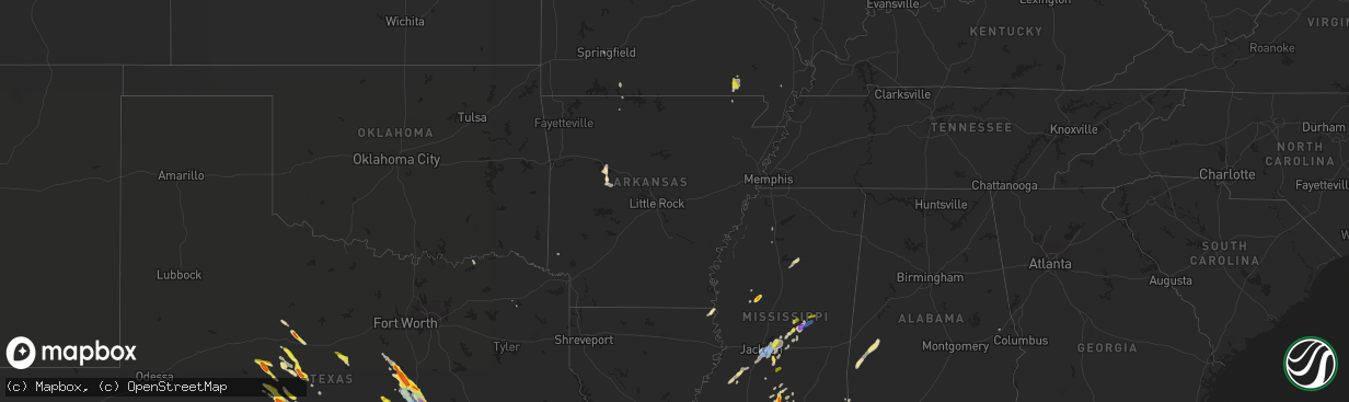
Hail Map in Arkansas on May 27, 2020
The weather event in Arkansas on May 27, 2020 includes Wind and Hail maps. 11 states and 416 cities were impacted and suffered possible damage. The total estimated number of properties impacted is 0.
Want more than just the map?
Turn this storm into a full workflow.
- Owner + property data so you know who to knock
- OnDemand branded weather history reports to win the "did we even have hail?" argument
- RoofTrace estimate so reps stop guessing numbers at the door
Bought this map? Upgrade within 7 days and we'll credit the $230. (10-15 min setup call)
Wind
Hail
0
Estimated number of impacted properties by a 1.00" hail or larger0
Estimated number of impacted properties by a 1.75" hail or larger0
Estimated number of impacted properties by a 2.50" hail or largerStorm reports in Arkansas
Arkansas
| Date | Description |
|---|---|
| 05/27/20203:41 PM CDT | Thunderstorm winds blew down a large tree on the lion's den golf course. |
| 05/27/20203:36 PM CDT | A storm spotter reported shingles blown off his roof in london... Ar. |
| 05/27/20207:43 AM CDT | At 1243 AM CDT, a severe thunderstorm was located near Wesson, or 8 miles west of El Dorado, moving northeast at 25 mph. HAZARD...60 mph wind gusts and quarter size hail. SOURCE...Radar indicated. IMPACT...Hail damage to vehicles is expected. Expect wind damage to roofs, siding, and trees. Locations impacted include... El Dorado, Smackover, Norphlet, Calion, Lisbon, Newell, Kenova and Catesville. |
| 05/27/20202:00 AM CDT | At 700 PM CDT, a severe thunderstorm was located near Holly Grove, or 12 miles southeast of Clarendon, moving northeast at 10 mph. HAZARD...60 mph wind gusts and quarter size hail. SOURCE...Radar indicated. IMPACT...Hail damage to vehicles is expected. Expect wind damage to roofs, siding, and trees. Locations impacted include... Holly Grove... Palmer... Blackton... Pine City... Lawrenceville... Ragtown... Duncan... Louisiana Purchase State Park... |
| 05/26/202010:30 PM CDT | At 329 PM CDT, a severe thunderstorm was located over Lake Dardanelle, or 7 miles west of Russellville, moving north at 15 mph. HAZARD...60 mph wind gusts and quarter size hail. SOURCE...Radar indicated. IMPACT...Hail damage to vehicles is expected. Expect wind damage to roofs, siding, and trees. Locations impacted include... Russellville... Clarksville... Lamar... Dover... London... Knoxville... Lake Dardanelle State Park... Lake Dardanelle... Mt Nebo State Park... Augsburg... Ludwig... Piney Bay Recreation Area... Delaware... New Blaine...This includes Interstate 40 between mile markers 63 and 80. |
| 05/26/202010:10 PM CDT | At 309 PM CDT, a severe thunderstorm was located near Petit Jean River WMA, or 12 miles south of Russellville, moving east at 25 mph. HAZARD...60 mph wind gusts and quarter size hail. SOURCE...Radar indicated. IMPACT...Hail damage to vehicles is expected. Expect wind damage to roofs, siding, and trees. Locations impacted include... Russellville... Dardanelle... Atkins... Pottsville... Ola... Petit Jean State Park... Lake Dardanelle State Park... Carden Bottoms... Petit Jean River WMA... Galla Creek WMA... Mt Nebo State Park... Mosley... Lake Dardanelle... Casa... Birta... Ada... Lakeview in Yell County... Holla Bend... Mt George... Pontoon...This includes Interstate 40 between mile markers 81 and 95. |
All States Impacted by Hail Map on May 27, 2020
Cities Impacted by Hail Map on May 27, 2020
- Belzoni, MS
- Tchula, MS
- Lexington, MS
- Tuscola, TX
- Wiggins, MS
- Lumberton, MS
- Brooklyn, MS
- College Station, TX
- Burlington, TX
- Lott, TX
- Rosebud, TX
- Cameron, TX
- Grand Rapids, MI
- Wyoming, MI
- Bedias, TX
- Sonora, TX
- Elgin, TX
- Thrall, TX
- Coupland, TX
- Junction, TX
- London, TX
- Leakey, TX
- Barksdale, TX
- Rocksprings, TX
- Camp Wood, TX
- Danville, AR
- Sumrall, MS
- Lake Providence, LA
- Mayersville, MS
- State Line, MS
- Leakesville, MS
- Richton, MS
- Salado, TX
- Medina, TX
- Bandera, TX
- Hondo, TX
- Tarpley, TX
- Hutto, TX
- Georgetown, TX
- Pflugerville, TX
- Round Rock, TX
- Okeechobee, FL
- Marble Falls, TX
- Burnet, TX
- Uvalde, TX
- Kissee Mills, MO
- Woodway, TX
- McGregor, TX
- Waco, TX
- Crawford, TX
- Valley Mills, TX
- Lorena, TX
- Hewitt, TX
- Hext, TX
- Menard, TX
- Brady, TX
- Eden, TX
- Melvin, TX
- Demopolis, AL
- Linden, AL
- Rockdale, TX
- Port Saint Lucie, FL
- Jensen Beach, FL
- Sealy, TX
- Bertram, TX
- Liberty, TX
- Wingate, TX
- Bronte, TX
- Winters, TX
- Norton, TX
- Beeville, TX
- Hempstead, TX
- Prairie View, TX
- Hockley, TX
- Waller, TX
- Thorndale, TX
- Morgan, TX
- Foxworth, MS
- Kokomo, MS
- Columbia, MS
- Carson, MS
- Bassfield, MS
- Hermanville, MS
- Crystal Springs, MS
- Pattison, MS
- Utica, MS
- Hazlehurst, MS
- Union Church, MS
- San Antonio, TX
- Millersview, TX
- Doole, TX
- Voss, TX
- Bellville, TX
- Milano, TX
- Hearne, TX
- Bryan, TX
- Caldwell, TX
- Blackwell, TX
- Skidmore, TX
- Taft, TX
- Kerrville, TX
- Karnes City, TX
- Atascosa, TX
- Pipe Creek, TX
- Von Ormy, TX
- Doss, TX
- Mountain Home, TX
- Mico, TX
- Bulverde, TX
- Mason, TX
- Hunt, TX
- Elmendorf, TX
- Woodsboro, TX
- Pleasanton, TX
- Miles, TX
- Falls City, TX
- Center Point, TX
- Harper, TX
- Rio Medina, TX
- Sinton, TX
- Castroville, TX
- Three Rivers, TX
- Ingram, TX
- Jbsa Ft Sam Houston, TX
- Kenedy, TX
- Rowena, TX
- Ballinger, TX
- Campbellton, TX
- Jbsa Lackland, TX
- Paint Rock, TX
- Comfort, TX
- Floresville, TX
- Helotes, TX
- Boerne, TX
- Fredericksburg, TX
- Gatesville, TX
- Florence, TX
- Briggs, TX
- Kenansville, FL
- Saint Cloud, FL
- Leander, TX
- Magnolia, TX
- Moody, TX
- Walnut Grove, MS
- Rio Frio, TX
- Whitney, TX
- Reagan, TX
- Marlin, TX
- Meridian, TX
- Riesel, TX
- Clifton, TX
- Aquilla, TX
- China Spring, TX
- Chilton, TX
- West, TX
- Bremond, TX
- Elm Mott, TX
- New Augusta, MS
- Beaumont, MS
- Nome, TX
- Beaumont, TX
- China, TX
- Devers, TX
- Calhoun City, MS
- Cuero, TX
- Shiner, TX
- Gonzales, TX
- Yoakum, TX
- East Bernard, TX
- Dale, TX
- Lockhart, TX
- Luling, TX
- Abilene, TX
- Clyde, TX
- Ovalo, TX
- Chappell Hill, TX
- Brenham, TX
- Friendswood, TX
- Webster, TX
- Houston, TX
- Poplarville, MS
- Long Beach, MS
- Vero Beach, FL
- Lena, MS
- Anahuac, TX
- Bluffton, TX
- Buchanan Dam, TX
- Tow, TX
- Pearl, MS
- Concan, TX
- Utopia, TX
- Daphne, AL
- Bay Minette, AL
- Prentiss, MS
- Burton, TX
- Fairdealing, MO
- Oxly, MO
- Doniphan, MO
- Grandin, MO
- Gouldbusk, TX
- Encinal, TX
- Snook, TX
- Somerville, TX
- Eight Mile, AL
- Mobile, AL
- Satsuma, AL
- Semmes, AL
- Saraland, AL
- Taylor, TX
- Rogers, TX
- Montgomery, TX
- Loxahatchee, FL
- Ashland, ME
- Cleveland, TX
- Coleman, TX
- Palm City, FL
- Stuart, FL
- Pearsall, TX
- Richland Springs, TX
- San Saba, TX
- Atmore, AL
- McDavid, FL
- Novice, TX
- Braxton, MS
- Brandon, MS
- D Hanis, TX
- Sabinal, TX
- Lohn, TX
- Oakland, MS
- North Zulch, TX
- Harrison, AR
- Forest, MS
- Morton, MS
- Carthage, MS
- Gause, TX
- Pelahatchie, MS
- Lacassine, LA
- Lake Arthur, LA
- Philadelphia, MS
- Wallagrass, ME
- Eagle Lake, ME
- Fort Kent, ME
- Brookshire, TX
- Lucedale, MS
- Franklin, TX
- Plantersville, TX
- Navasota, TX
- Opelika, AL
- North Fort Myers, FL
- New Waverly, TX
- Huntsville, TX
- Harwood, TX
- Dardanelle, AR
- Wallisville, TX
- Albany, TX
- Baird, TX
- Santa Anna, TX
- Washington, TX
- Crestview, FL
- Gore Springs, MS
- Lexington, TX
- Dime Box, TX
- Kopperl, TX
- Carriere, MS
- Picayune, MS
- Wharton, TX
- Neely, MS
- Mount Vernon, TX
- Flowood, MS
- Breaux Bridge, LA
- Saint Martinville, LA
- Bogalusa, LA
- Bush, LA
- Big Wells, TX
- Duck Hill, MS
- Del Valle, TX
- Waelder, TX
- Temple, TX
- Troy, TX
- Wilmer, AL
- De Leon, TX
- Gorman, TX
- Eagle Lake, TX
- Fort Pierce, FL
- Toxey, AL
- Butler, AL
- Gilbertown, AL
- Cameron, LA
- Bell City, LA
- Defuniak Springs, FL
- Maxwell, TX
- Kyle, TX
- Springfield, MO
- Pasadena, TX
- McLain, MS
- Dayton, TX
- Laurel Hill, FL
- Laredo, TX
- Iola, TX
- Moulton, TX
- Flatonia, TX
- Calvert, TX
- Glen Rose, TX
- Delaware, AR
- Jarrell, TX
- Gulfport, MS
- Mount Olive, MS
- Yancey, TX
- Vanderpool, TX
- Goldsboro, TX
- Lawn, TX
- Anson, TX
- Biggers, AR
- Parma, MO
- Martindale, TX
- London, AR
- Austin, TX
- Lueders, TX
- Fruitdale, AL
- Ocean Springs, MS
- Vancleave, MS
- Florence, MS
- Richland, MS
- Terry, MS
- Buckholts, TX
- Anderson, TX
- Naylor, MO
- Boswell, OK
- Bastrop, TX
- Red Rock, TX
- Indiantown, FL
- Collins, MS
- Tylertown, MS
- Oak Vale, MS
- Buda, TX
- Rosanky, TX
- Lampasas, TX
- Pinola, MS
- Newhebron, MS
- Killeen, TX
- Biloxi, MS
- Baytown, TX
- West Palm Beach, FL
- Granger, TX
- Itta Bena, MS
- Richards, TX
- Missouri City, TX
- Silver Creek, MS
- Cedar Creek, TX
- Edwards, MS
- Grover, CO
- Pittsburg, TX
- Seminary, MS
- Converse, TX
- Honey Grove, TX
- Telephone, TX
- Jackson, MS
- Pearland, TX
- Marion, TX
- Saint Hedwig, TX
- Horatio, AR
- Portland, TX
- Hackberry, LA
- Bartlett, TX
- Elkton, FL
- Richmond, TX
- Ola, AR
- Bleiblerville, TX
- Crystal City, TX
- Hull, TX
- Jayess, MS
- Brownwood, TX
- Harviell, MO
- Poplar Bluff, MO
- New Caney, TX
- Conroe, TX
- Bangs, TX
- Rosenberg, TX
- Grand Bay, AL
- Moss Point, MS
- Pass Christian, MS
- Diamondhead, MS
- Dublin, TX
- Lead Hill, AR
- La Pryor, TX
- Little River Academy, TX
- Belton, TX
- Wallis, TX
- York, AL
- Ward, AL
- Pennington, AL
- Batesville, MS
- Courtland, MS
- Sebastian, FL
- Lake Charles, LA
- Little River, AL
- Cypress, TX
- Katy, TX
- Spring, TX
- Humble, TX
- Tomball, TX
- South Houston, TX
- La Porte, TX
- Deer Park, TX
- League City, TX
- Dickinson, TX
- Hitchcock, TX
- Galveston, TX
- Texas City, TX
- Santa Fe, TX
- La Marque, TX
- Eddy, TX
- Hallettsville, TX
- Desdemona, TX
- Liberty Hill, TX
- Mendenhall, MS


