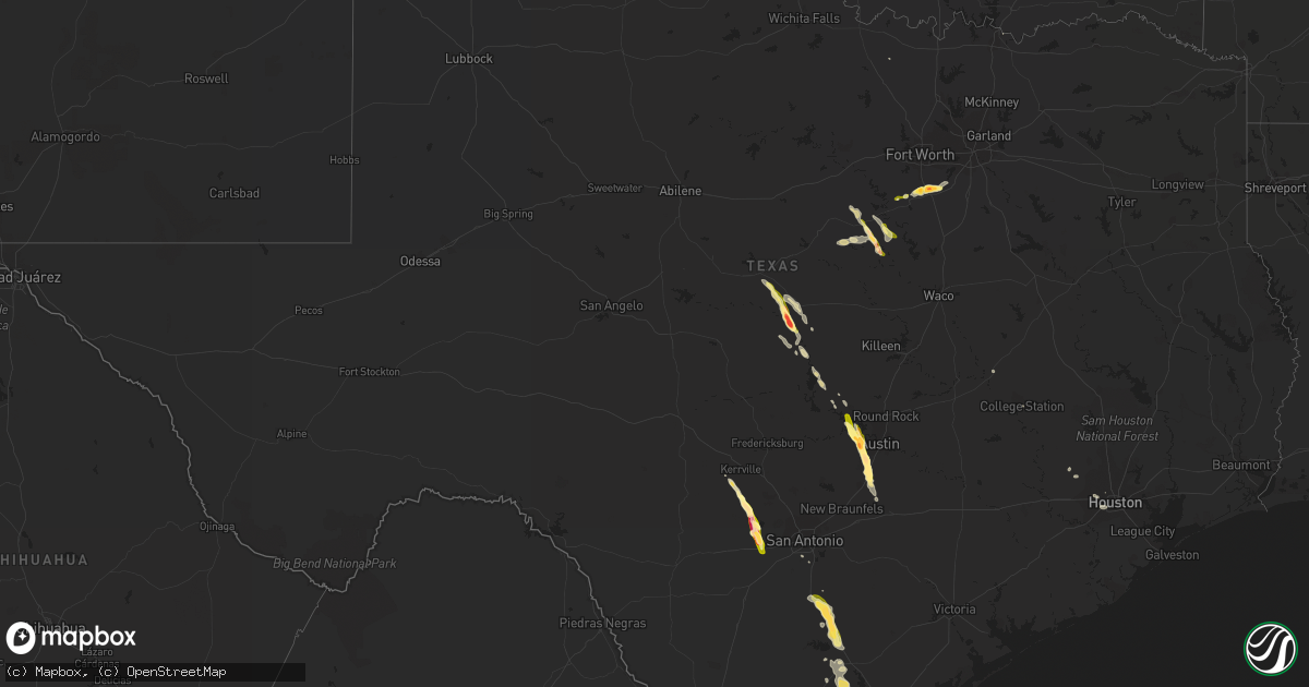
Hail Map in Texas on May 27, 2014
Get this storm
May 27 map
$229
one time, instant access
Download today. No call, no setup
Keep the $229
Bought the map and want the full workflow? Apply the entire $229 to a subscription within 7 days. None of it is wasted.
Every map, not just this one
This buys you this map. Subscription and you get every map we run, in the markets you choose from a few cities to whole states to nationwide. Plus real-time alerts the moment a storm fires.
Contact data
Name, contact info, occupancy, even credit band for addresses in the footprint. You go from where it hit to who to call.
Become the source they trust
Unlimited branding weather history reports on demand. You already have the documented answer ready for the property owner, and you are the one who showed up with it.
Property data and RoofTrace estimates
Pull up any address you have got, its value and the exact code rules for that jurisdiction, straight from One Click Code. Then RoofTrace estimates the squares, pitch, and roof value, priced the way you price.
Storm reports in Texas
Texas
| Date | Description |
|---|---|
| 05/27/20146:46 PM CDT | Hail fell for 4 to 7 minutes. Also...a wall cloud was observed 5 to 7 miles away |
| 05/27/20146:40 PM CDT | A local report indicates 1.25 inch wind near 14 ENE HONDO |
| 05/27/20146:38 PM CDT | Quarter to half dollar sized hail on the south side of alice. Power is out on the south side of alice also. |
| 05/27/20146:38 PM CDT | Alice international airport asos measured a gust to 50 knots. |
| 05/27/20146:37 PM CDT | Large trees blown down in the central part of alice. |
| 05/27/20146:33 PM CDT | Baseball size hail in the center of the town of alice. |
| 05/27/20146:30 PM CDT | Public reported brief tornado touchdown last night just east of lake buchanan. No precise info known. Time and location estimated from radar. |
| 05/27/20146:30 PM CDT | Nws storm survey team has a preliminary rating of ef1 tornado damage to the southeast part of the city of alice. Estimated maximum wind speed of 110 mph. |
| 05/27/20146:25 PM CDT | A local report indicates 1.25 inch wind near 6 WSW MEDINA |
| 05/27/20145:47 PM CDT | A local report indicates 1.75 inch wind near 1 W BANDERA |
| 05/27/20145:40 PM CDT | A local report indicates 2.00 inch wind near 3 NE ALVARADO |
| 05/27/20145:35 PM CDT | Half dollar size hail 4 se of briar oaks |
| 05/27/20145:23 PM CDT | Quarter size hail 3 miles north of keene |
| 05/27/20145:20 PM CDT | 2 foot diameter trees down on fm2280 north of keene |
| 05/27/20145:19 PM CDT | Quarter hail 7 miles northeast of walnut springs |
| 05/27/20145:19 PM CDT | Game warden reported golf ball hail near harmony ridge |
| 05/27/20145:15 PM CDT | A few hailstones were golfball size. |
| 05/27/20145:02 PM CDT | Quarter hail 3 se of godley |
| 05/27/20145:00 PM CDT | Numerous trees down or uprooted... Power poles down... And one carport damaged |
| 05/27/20144:58 PM CDT | Deputy reported baseball hail on state highway 16 |
| 05/27/20144:38 PM CDT | Reported near merger of interstate 37 and highway 281. |
| 05/27/20143:56 PM CDT | A local report indicates 1.00 inch wind near CAMPBELLTON |
| 05/27/20149:39 AM CDT | Power lines down and sagging. Power pole down at 51st and ave s. |
| 05/27/20148:30 AM CDT | Power lines down and sagging. Power pole down at 51st and ave s. |
| 05/27/20148:08 AM CDT | Large containers blown off an 18 wheeler at barbers cut terminal. |
| 05/27/20147:35 AM CDT | *** 11 inj *** wind cuased flying debris at construction site at bay area blvd and w fairmont parkway causing multiple injuries. |
| 05/27/20147:35 AM CDT | *** 15 inj *** fifteen minor injuries at a construction site from flying debris |
| 05/26/20149:22 PM CDT | A local report indicates 1.00 inch wind near 4 NE MARTINDALE |
| 05/26/20149:15 PM CDT | A local report indicates 1.50 inch wind near 1 SSE KYLE |
| 05/26/20148:55 PM CDT | A local report indicates 1.75 inch wind near KYLE |
| 05/26/20148:53 PM CDT | A local report indicates 1.00 inch wind near 2 E KYLE |
| 05/26/20148:40 PM CDT | A local report indicates 1.50 inch wind near BUDA |
| 05/26/20148:35 PM CDT | A local report indicates 2.00 inch wind near 2 SSW TANGLEWOOD FOREST |
| 05/26/20148:30 PM CDT | A local report indicates 1.75 inch wind near 2 NW UHLAND |
| 05/26/20148:26 PM CDT | A local report indicates 1.50 inch wind near 4 W SUNSET VALLEY |
| 05/26/20148:19 PM CDT | A local report indicates 1.75 inch wind near 5 W SUNSET VALLEY |
| 05/26/20148:17 PM CDT | A local report indicates 1.00 inch wind near 3 SE BEE CAVE |
| 05/26/20148:15 PM CDT | A local report indicates 1.50 inch wind near 6 S BEE CAVE |
| 05/26/20148:05 PM CDT | Golf ball size hail reported |
| 05/26/20148:02 PM CDT | Reports of numerous trees down on st. Marys street |
| 05/26/20148:02 PM CDT | A local report indicates 1.00 inch wind near 2 ESE LAKEWAY |
| 05/26/20148:01 PM CDT | A local report indicates 61 MPH wind near FALFURRIAS |
| 05/26/20148:00 PM CDT | Delayed report from last evening |
| 05/26/20147:56 PM CDT | A local report indicates 1.00 inch wind near 2 W LAKEWAY |
| 05/26/20147:52 PM CDT | Oak trees down at lasater street and rice street |
| 05/26/20147:52 PM CDT | Reports of structural damage to business signs on center street |
| 05/26/20147:45 PM CDT | Nws storm survey team has a preliminary rating of ef1 tornado damage 2 miles south of premont. Estimated maximum wind speed of 101 mph. Power poles snapped. |
| 05/26/20147:00 PM CDT | A local report indicates 1.00 inch wind near 1 W CASTROVILLE |
All States Impacted by Hail Map on May 27, 2014
Cities Impacted by Hail Map on May 27, 2014
- Pisgah Forest, NC
- Hendersonville, NC
- Horse Shoe, NC
- Penrose, NC
- Etowah, NC
- Early, TX
- Stapleton, GA
- Avera, GA
- Louisville, GA
- Lantry, SD
- Eagle Butte, SD
- Bridport, VT
- Middlebury, VT
- Shoreham, VT
- Whiting, VT
- Manchaca, TX
- Buda, TX
- Bandera, TX
- Alice, TX
- Minford, OH
- Beaver, OH
- Falls City, TX
- Union Center, SD
- Three Rivers, TX
- Campbellton, TX
- Whitsett, TX
- Deadwood, SD
- Rapid City, SD
- Nemo, SD
- Garyville, LA
- Edgard, LA
- Mount Airy, LA
- Alvarado, TX
- Greensburg, KY
- Columbia, KY
- Kendall, WI
- Scobey, MS
- Tillatoba, MS
- Medina, TX
- Myersville, MD
- Frederick, MD
- Leesburg, VA
- Godley, TX
- Cleburne, TX
- Jackson, OH
- Concepcion, TX
- Madera, PA
- Ramey, PA
- Houtzdale, PA
- Philadelphia, MS
- Noxapater, MS
- Reader, WV
- Pine Grove, WV
- Iredell, TX
- Hico, TX
- Batesville, MS
- Midland, SD
- Kyle, TX
- Fairfield, IA
- Ontario, WI
- La Farge, WI
- Hillsboro, WI
- Kingston, TN
- Aberdeen, SD
- Ipswich, SD
- Trenton, NC
- Richlands, NC
- Grayson, KY
- San Saba, TX
- Goldthwaite, TX
- Greenup, KY
- Quinn, SD
- Rockville, MD
- Eddyville, IL
- Cresbard, SD
- Hill City, SD
- Richland, IA
- Bertram, TX
- Lead, SD
- Saint James, LA
- Garland, NC
- Hamilton, VA
- Paeonian Springs, VA
- Cuttingsville, VT
- North Clarendon, VT
- Rutland, VT
- Proctor, VT
- West Rutland, VT
- Pittsford, VT
- Florence, VT
- Center Rutland, VT
- Dickerson, MD
- Beallsville, MD
- Poolesville, MD
- Vergennes, VT
- Salisbury, VT
- Mount Holly, VT
- East Wallingford, VT
- Belmont, VT
- Brandon, VT
- Castleton, VT
- Burleson, TX
- Joshua, TX
- Rio Medina, TX
- Pipe Creek, TX
- Hondo, TX
- Castroville, TX
- Mico, TX
- Highmore, SD
- East Lynn, WV
- Genoa, WV
- Terry, MT
- Cohagen, MT
- Cody, NE
- Pollocksville, NC
- Meridian, TX
- George West, TX
- Keene, TX
- Venus, TX
- Midlothian, TX
- Rineyville, KY
- Vine Grove, KY
- Houston, TX
- Dongola, IL
- Arthur, IA
- Geddes, SD
- Plano, IA
- Seymour, IA
- Promise City, IA
- Coldwater, MS
- Osceola, IA
- Jesup, GA
- Kaycee, WY
- Premont, TX
- McArthur, OH
- Ray, OH
- Alcolu, SC
- Gable, SC
- Wingo, KY
- Clinton, KY
- Mayfield, KY
- Lucasville, OH
- Amory, MS
- Angela, MT
- Musselshell, MT
- Roundup, MT
- Ullin, IL
- Pulaski, IL
- Clio, SC
- Dillon, SC
- Eastview, KY
- Cecilia, KY
- Forsyth, MT
- Austin, TX
- Fayette, AL
- Dupree, SD
- White Sulphur Springs, MT
- Ringling, MT
- Orange Grove, TX
- Maxwell, TX
- Leander, TX
- Spicewood, TX
- Paducah, KY
- Denison, TX
- Clover, SC
- Kings Mountain, NC
- Sandia, TX
- Robstown, TX
- Bethesda, MD
- San Antonio, TX
- Poynette, WI
- Madison, MN
- Buffalo Gap, SD
- Gaithersburg, MD
- Germantown, MD
- Encino, TX
- Riviera, TX
- Falfurrias, TX
- Sandy Hook, CT
- Southbury, CT
- Wessington, SD
- Batavia, OH
- Milford, OH
- Walkersville, MD
- Thurmont, MD
- Millerstown, PA
- Newport, PA
- Kerrville, TX
- Louisville, NE
- Plattsmouth, NE
- Weeping Water, NE
- Nehawka, NE
- Evergreen, NC
- Bellaire, TX
- Marshall, MN
- Marion Junction, AL
- Ashburn, VA
- Forest Grove, MT
- Lavina, MT
- Campbellsville, KY
- Bloomfield, KY
- Fulton, KY
- Martin, TN
- South Fulton, TN
- Water Valley, KY
- Kimball, SD
- Harriman, TN
- Oakdale, TN
- Bluff Dale, TX
- Zephyr, TX
- Mullin, TX
- Floresville, TX
- San Diego, TX
- Gastonia, NC
- Keystone, SD
- Fort Pierre, SD
- Hayes, SD
- Millport, AL
- Bloomfield Hills, MI
- Blue Creek, OH
- West Union, OH
- Leitchfield, KY
- Lometa, TX
- Rutledge, TN
- Washburn, TN
- McDonald, PA
- Tamms, IL
- Judith Gap, MT
- Lewistown, MT
- Lawrenceburg, KY
- South Shore, KY
- Pleasanton, TX
- Arlington, TN
- Denton, KY
- Rush, KY
- Louisa, KY
- Hermosa, SD
- Fairburn, SD
- Custer, SD
- Hot Springs, SD
- Walnut Springs, TX
- Malone, FL
- Greenwood, FL
- Platte, SD
- West Liberty, KY
- Lampasas, TX
- Fort Gay, WV
- Hockley, TX
- Napoleonville, LA
- Convent, LA
- Belle Rose, LA
- La Follette, TN
- South Webster, OH
- Hendrix, OK
- Carbon Hill, AL
- Nauvoo, AL
- Church Hill, TN
- Hummelstown, PA
- Harrisburg, PA
- Middletown, PA
- Loris, SC
- Tunica, MS
- Burnet, TX
- Hysham, MT
- Roff, OK
- Sallis, MS
- Goodman, MS
- New Florence, PA
- Harned, KY
- Porter, MN
- Staffordsville, KY
- Westport, NY
- Mineville, NY
- Port Henry, NY
- Joffre, PA
- Bulger, PA
- Burgettstown, PA
- Hickory, PA
- Avella, PA
- Cypress, TX
- Pataskala, OH
- Hebron, OH
- Murphy, NC
- Louisville, MS
- Carthage, MS
- Asheboro, NC
- Harrells, NC
- Camp Douglas, WI
- Pleasant Plain, OH
- Blanchester, OH
- Lynx, OH
- Whiteville, NC
- Leon, WV
- Clayton, AL
- Lafayette, LA
- Breaux Bridge, LA
- Webster, KY
- Bridgewater, CT
- New Milford, CT
- Murray, NE
- Salineville, OH
- Monticello, KY
- Brandon, MS
- Lena, MS
- Midland, OH
- Latta, SC
- Caneyville, KY
- New Bloomfield, PA
- Shermans Dale, PA
- Vacherie, LA
- Gramercy, LA
- Reserve, LA
- Lebanon, PA
- Wallace, NC
- Robinsonville, MS
- Wood, SD
- Midway, AL
- Maxton, NC
- Laurinburg, NC
- Courtland, MS
- Sardis, MS
- Pope, MS
- Oakland, MS
- Moundsville, WV
- Powhatan Point, OH
- Coalport, PA
- Fort Knox, KY
- Coffeeville, MS
- La Valle, WI
- Wonewoc, WI
- Duncannon, PA
- Landisburg, PA
- Elizabethtown, KY
- Dauphin, PA
- Gibson, GA
- Mount Eden, KY
- Peebles, OH
- Rose Hill, NC
- Senatobia, MS
- Lusk, WY
- Manville, WY
- Glen Rose, TX
- Morgan, TX
- Kopperl, TX
- West Grove, PA
- Troy, MI
- Halifax, PA
- Parmelee, SD
- Wellston, OH
- Coalton, OH
- Chadbourn, NC
- Spraggs, PA
- Franklin Furnace, OH
- Townley, AL
- Great Falls, VA
- Sterling, VA
- Ryegate, MT
- Salem, WV
- West Union, WV
- Center Point, WV
- College Park, MD
- Forestburg, TX
- Packwood, IA
- Hearne, TX
- Lynchburg, VA
- Wind Ridge, PA
- Old Fort, TN
- Ocoee, TN
- Bartow, GA
- Elizabethtown, NC
- Waterford, VA
- Elba, AL
- Carrollton, OH
- Marble Falls, TX
- Imperial, PA
- Clinton, PA
- Potomac, MD
- Rowland, NC
- Union Springs, AL
- Jacksonville, GA
- Hernando, MS
- Odebolt, IA
- Duson, LA
- Rayne, LA
- Annville, PA
- Manheim, PA
- Mount Gretna, PA
- Palmyra, PA
- Tazewell, TN
- New Tazewell, TN
- Speedwell, TN
- Cochranville, PA
- Monroe, NC
- Stephenville, TX
- Mount Vernon, KY
- Brodhead, KY
- Forest, VA
- Westview, KY
- Memphis, TN
- Matthews, GA
- Wrens, GA
- Dublin, TX
- Southside, WV
- West Columbia, SC
- Gaston, SC
- Martindale, TX
- Basile, LA
- Como, MS
- Muldraugh, KY
- Belzoni, MS
- Isola, MS
- Pelham, NC
- Providence, NC
- Milledgeville, GA
- College Station, TX
- Hudson, KY
- Garfield, KY
- Sarah, MS
- Benton, MS
- Yazoo City, MS
- Gallipolis Ferry, WV
- Chipley, FL
- Hatchechubbee, AL
- Hurtsboro, AL
- Otway, OH
- Lockhart, TX
- Luling, TX
- Colbert, OK
- Boaz, KY
- Symsonia, KY
- Danville, VA
- Parkers Lake, KY
- Canby, MN
- Blenheim, SC
- Bennettsville, SC
- Croghan, NY
- Hardinsburg, KY
- Cordova, TN
- White Lake, SD
- Falls Church, VA
- Dunn Loring, VA
- McLean, VA
- Vienna, VA
- Jasper, AL
- New Zion, SC
- Shadyside, OH
- Glen Dale, WV
- Mcmechen, WV
- Bellaire, OH
- Merriman, NE
- Lovingston, VA
- Crown City, OH
- Ashton, WV
- Glenwood, WV
- Lesage, WV
- Kennedy, AL
- Sulphur, IN
- Melvin, KY
- Herndon, VA
- Aliceville, AL
- Rio, WI
- Arlington, WI
- Detroit, MI
- Opp, AL
- McColl, SC
- Gibson, NC
- Jacksonville, NC
- Mount Sherman, KY
- Powder Springs, TN
- Portsmouth, OH
- Wheelersburg, OH
- Boyds, MD
- Birmingham, MI
- Clawson, MI
- Royal Oak, MI
- Cleveland, TN
- Verona, VA
- Staunton, VA
- Eubank, KY
- Science Hill, KY
- Wilton, WI
- Jacobsburg, OH
- Dearing, GA
- Sulphur, OK
- New Cumberland, PA
- Highspire, PA
- York, SC
- Leavenworth, IN
- English, IN
- Ekron, KY
- Hitchins, KY
- Duffield, VA
- Gate City, VA
- Isonville, KY
- Sandy Hook, KY
- Elizabeth, IN
- West Point, KY
- Brandenburg, KY
- Laconia, IN
- Mechanicstown, OH
- Ticonderoga, NY
- Nettleton, MS
- Hedrick, IA
- Marshville, NC
- Millington, TN
- Bladenboro, NC
- Bonita Springs, FL
- Estero, FL
- West Portsmouth, OH
- South Portsmouth, KY
- Scott, LA
- Stout, OH
- Manchester, OH
- Salem, KY
- Marion, KY
- Salvisa, KY
- Blunt, SD
- Webbville, KY
- Monroe, WI
- Villa Ridge, IL
- Olmsted, IL
- Burton, WV
- Londonderry, OH
- Cottondale, FL
- Somerset, KY
- Dawson, MN
- Boyd, MN
- Derwood, MD
- Aberdeen, MS
- Okolona, MS
- Holbrook, PA
- New Freeport, PA
- Aleppo, PA
- Genesee, PA
- Henderson, WV
- Apple Grove, WV
- Laurel Hill, NC
- Flat Rock, NC
- East Flat Rock, NC
- Lumberton, NC
- Argillite, KY
- Pikeville, KY
- Jenkins, KY
- Van Lear, KY
- Cayce, SC
- Columbia, SC
- Ickesburg, PA
- Hodgenville, KY
- Pelahatchie, MS
- Madison, MS
- Canton, MS
- Chaplin, KY
- Elliottsburg, PA
- Thibodaux, LA
- Smithville, MS
- Marietta, SC
- Woodville, MS
- Kingsville, TX
- Cerro Gordo, NC
- Beulaville, NC
- Water Valley, MS
- Tar Heel, NC
- Sturgis, SD
- Wall, SD
- Sarita, TX
- Buffalo, MT


