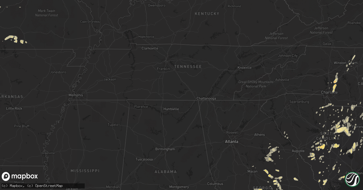
Hail Map in South Carolina on May 27, 2011
Get this storm
May 27 map
$229
one time, instant access
Download today. No call, no setup
Keep the $229
Bought the map and want the full workflow? Apply the entire $229 to a subscription within 7 days. None of it is wasted.
Every map, not just this one
This buys you this map. Subscription and you get every map we run, in the markets you choose from a few cities to whole states to nationwide. Plus real-time alerts the moment a storm fires.
Contact data
Name, contact info, occupancy, even credit band for addresses in the footprint. You go from where it hit to who to call.
Become the source they trust
Unlimited branding weather history reports on demand. You already have the documented answer ready for the property owner, and you are the one who showed up with it.
Property data and RoofTrace estimates
Pull up any address you have got, its value and the exact code rules for that jurisdiction, straight from One Click Code. Then RoofTrace estimates the squares, pitch, and roof value, priced the way you price.
Storm reports in South Carolina
South Carolina
| Date | Description |
|---|---|
| 05/27/20116:00 PM CDT | Trees down along macedonia church road |
| 05/27/20113:24 PM CDT | Several branches down 2 inches in diameter. |
| 05/27/20113:24 PM CDT | Colleton state park reported several trees down on park property and 3 trees down at the entrance along jefferies highway. |
| 05/27/20112:21 PM CDT | A local report indicates 1.00 inch wind near WALTERBORO |
| 05/27/20111:55 PM CDT | Highway dept reports large tree down across us-1 near ousleydale road |
| 05/27/20111:13 PM CDT | A local report indicates 1.00 inch wind near BARNWELL |
| 05/27/201112:00 PM CDT | One inch hail reported on hatchery road. |
| 05/27/201111:35 AM CDT | Tree down on west hampton point drive. |
| 05/27/20111:10 AM CDT | Sheriff dispatch reported trees down on the south side of bishopville. |
| 05/27/20111:03 AM CDT | Tree down at the intersection of highway 174 and toogoodoo road. Report from the charleston county warning point. |
| 05/27/201112:58 AM CDT | Sheriff dispatch reported trees down elmore road. |
| 05/27/201112:41 AM CDT | Sheriff dispatch reported trees down spring hill road. |
| 05/26/201111:56 PM CDT | Sheriff dispatch reported golf ball size hail along black river road. |
| 05/26/201111:43 PM CDT | Fire department reported one tree down along sams point road. |
| 05/26/201111:15 PM CDT | Sheriff dispatch reported trees down in north. |
| 05/26/201110:50 PM CDT | Cocorahs observer called and reported 1 to 2 inch hail near the town of north. |
| 05/26/20119:12 PM CDT | Barnwell county dispatch reports trees down on moonlight road in williston |
| 05/26/20118:47 PM CDT | Lexington dispatch reports one tree down on tindall road in pelion |
All States Impacted by Hail Map on May 27, 2011
Cities Impacted by Hail Map on May 27, 2011
- Meigs, GA
- Whigham, GA
- Cairo, GA
- Pelham, GA
- Jacksonville, FL
- Florence, SC
- Darlington, SC
- Spencer, NY
- Lockwood, NY
- Crescent City, FL
- Pomona Park, FL
- San Mateo, FL
- Satsuma, FL
- East Palatka, FL
- Palatka, FL
- Hartsville, SC
- Patrick, SC
- Murdock, KS
- Cheney, KS
- Kingman, KS
- McClure, PA
- Lewistown, PA
- Mifflintown, PA
- Port Royal, PA
- Mifflin, PA
- Wasola, MO
- Noble, MO
- Squires, MO
- Ava, MO
- Drury, MO
- Toomsboro, GA
- Lancaster, SC
- Waxhaw, NC
- South Hill, VA
- Hollywood, SC
- Green Pond, SC
- Edisto Island, SC
- Alamo, GA
- Little Falls, NY
- Middleville, NY
- Frankfort, NY
- Ilion, NY
- Herkimer, NY
- Newport, NY
- Nelliston, NY
- Palatine Bridge, NY
- Sprakers, NY
- Canajoharie, NY
- Fort Plain, NY
- Leesburg, FL
- Tavares, FL
- Rangeley, ME
- Phillips, ME
- Wellsboro, PA
- Gaines, PA
- Middlebury Center, PA
- Burns, KS
- Potwin, KS
- El Dorado, KS
- Endicott, NY
- Johnson City, NY
- Vestal, NY
- Binghamton, NY
- Fair Play, MO
- Aldrich, MO
- Dadeville, MO
- Rowland, NC
- Diamond, MO
- Joplin, MO
- Neosho, MO
- Henderson, NC
- Creedmoor, NC
- Butner, NC
- Oxford, NC
- Stem, NC
- Moultrie, GA
- Holly Springs, NC
- Fuquay Varina, NC
- Cassville, MO
- Vance, SC
- Lancaster, NH
- Adirondack, NY
- Pottersville, NY
- Chestertown, NY
- Twin Mountain, NH
- Cunningham, KS
- Turon, KS
- Gaston, SC
- Pelion, SC
- Swansea, SC
- Estill, SC
- Norwood, GA
- Barnwell, SC
- Wiley Ford, WV
- Artemas, PA
- Cumberland, MD
- Clearville, PA
- Oldtown, MD
- Flintstone, MD
- Neeses, SC
- North, SC
- Shell Knob, MO
- Dolgeville, NY
- Stratford, NY
- Saint Johnsville, NY
- Hyndman, PA
- North Creek, NY
- Warrensburg, NY
- Brant Lake, NY
- Riparius, NY
- Johnsburg, NY
- Wevertown, NY
- Bakers Mills, NY
- Reidsville, GA
- Ludowici, GA
- Glennville, GA
- Baxley, GA
- Eastman, GA
- Brunswick, GA
- Hartsfield, GA
- Coolidge, GA
- Washington, VT
- Corinth, VT
- West Topsham, VT
- Lykens, PA
- Breezewood, PA
- Everett, PA
- Cheraw, SC
- Ticonderoga, NY
- Cameron, NC
- Mount Dora, FL
- Sorrento, FL
- Apopka, FL
- Zellwood, FL
- Jefferson, SC
- Pageland, SC
- Raeford, NC
- Red Springs, NC
- Fort Bragg, NC
- Strong, ME
- Colony, KS
- Kincaid, KS
- Salters, SC
- Greeleyville, SC
- Rock Hill, SC
- Chester, SC
- Miller, MO
- Ash Grove, MO
- Mount Vernon, MO
- Wells, NY
- Shoreham, VT
- Hague, NY
- Hazlehurst, GA
- Jesup, GA
- Uvalda, GA
- Surrency, GA
- Odum, GA
- Lyons, GA
- Towanda, PA
- Shirleysburg, PA
- James Creek, PA
- Broad Top, PA
- Three Springs, PA
- Dudley, PA
- Hesston, PA
- Six Mile Run, PA
- Hopewell, PA
- Mapleton Depot, PA
- Saxton, PA
- Huntingdon, PA
- Todd, PA
- Cassville, PA
- Calvin, PA
- Owego, NY
- Nichols, NY
- Prescott, KS
- Pleasanton, KS
- Walterboro, SC
- Ridgeley, WV
- Warfordsburg, PA
- Robertsdale, PA
- Wells Tannery, PA
- Crystal Spring, PA
- Waterfall, PA
- Wadmalaw Island, SC
- Dora, MO
- Winter Haven, FL
- Macksville, KS
- Stafford, KS
- St John, KS
- Iuka, KS
- Howey In The Hills, FL
- Astatula, FL
- Clermont, FL
- Ponte Vedra, FL
- Barton, MD
- Lonaconing, MD
- Belleview, FL
- Summerfield, FL
- Ocklawaha, FL
- McIntyre, GA
- Irwinton, GA
- Cameron, SC
- Edgemoor, SC
- Catawba, SC
- Rentz, GA
- Williston, SC
- North Anson, ME
- Solon, ME
- Bingham, ME
- Renovo, PA
- Cochran, GA
- Hawkinsville, GA
- Rembert, SC
- Dalzell, SC
- Sumter, SC
- Bishopville, SC
- Punta Gorda, FL
- Miami, OK
- Seneca, MO
- Fairland, OK
- Wyandotte, OK
- Holly Hill, SC
- Allensville, PA
- Mill Creek, PA
- Belleville, PA
- Blythewood, SC
- Ridgeway, SC
- Okeechobee, FL
- Mound City, KS
- Gratz, PA
- Halifax, PA
- Elizabethville, PA
- Spring Glen, PA
- Soperton, GA
- Mount Vernon, GA
- Gray, GA
- Belpre, KS
- Groveton, NH
- Guildhall, VT
- Lunenburg, VT
- Brackney, PA
- Little Meadows, PA
- Warren Center, PA
- Lugoff, SC
- Orlando, FL
- Pamplico, SC
- Adrian, GA
- Kite, GA
- Wrightsville, GA
- Durham, NC
- Apalachin, NY
- Lock Haven, PA
- Loganton, PA
- Mill Hall, PA
- Kannapolis, NC
- Harrisburg, NC
- Concord, NC
- Littlestown, PA
- Ruffin, SC
- Apex, NC
- Loxahatchee, FL
- Belle Glade, FL
- Laurinburg, NC
- Kingstree, SC
- Lake City, SC
- Round O, SC
- Coosawhatchie, SC
- Hardeeville, SC
- Ridgeland, SC
- Washburn, MO
- Exeter, MO
- Powell, MO
- Rocky Comfort, MO
- Pineville, MO
- Stella, MO
- Millmont, PA
- Milroy, PA
- Laurelton, PA
- Woodward, PA
- Savannah, GA
- Fleming, GA
- Pooler, GA
- Richmond Hill, GA
- Fort Stewart, GA
- Montpelier, VA
- Rockville, VA
- Saint Augustine, FL
- Chambersburg, PA
- Fayetteville, PA
- Gorham, NH
- Charlotte, NC
- Pitcher, NY
- El Dorado Springs, MO
- Nevada, MO
- Sheldon, MO
- Milo, MO
- Vass, NC
- Frostburg, MD
- East Dublin, GA
- Dublin, GA
- Enola, PA
- Mechanicsburg, PA
- Jefferson, NH
- Burlington Flats, NY
- Edmeston, NY
- Pinehurst, NC
- Waterbury Center, VT
- Waterbury, VT
- Rich Hill, MO
- Butler, MO
- Rockville, MO
- Horseheads, NY
- Breesport, NY
- Reading, VT
- Burke, VA
- Woodbridge, VA
- Fairfax, VA
- Fairfax Station, VA
- Annandale, VA
- Clifton, VA
- Beaufort, SC
- Bretton Woods, NH
- Chatham, VA
- Dry Fork, VA
- Twin City, GA
- Garfield, GA
- Danville, PA
- McBee, SC
- De Soto, GA
- Concord, VT
- Gilman, VT
- Hamer, SC
- Little Rock, SC
- Dillon, SC
- East Springfield, NY
- Cooperstown, NY
- Cherry Valley, NY
- Greensboro, GA
- Union Point, GA
- White Plains, GA
- Crawfordville, GA
- North Hudson, NY
- Newcomb, NY
- Morven, NC
- Schenevus, NY
- Kittrell, NC
- Wake Forest, NC
- Franklinton, NC
- Mims, FL
- Duncannon, PA
- Dauphin, PA
- Saint Stephen, SC
- Pineville, SC
- Green Cove Springs, FL
- Lemoyne, PA
- New Cumberland, PA
- Camp Hill, PA
- Macon, GA
- Sparta, GA
- Gridley, KS
- Raleigh, NC
- Randolph, NH
- Avilla, MO
- Sarcoxie, MO
- Reeds, MO
- Carthage, MO
- Orangeburg, SC
- Salley, SC
- Springfield, SC
- Athens, ME
- New Portland, ME
- Kingfield, ME
- Harmony, ME
- Londonderry, VT
- Dudley, GA
- Waynesboro, PA
- Elgin, SC
- Jordanville, NY
- Southern Pines, NC
- Aberdeen, NC
- Portal, GA
- Columbus, KS
- Galena, KS
- Baxter Springs, KS
- Riverton, KS
- Ridgedale, MO
- Eden Mills, VT
- Hyde Park, VT
- Fairhope, PA
- Orange City, FL
- Bolivar, MO
- Louisburg, MO
- Polk, MO
- Half Way, MO
- Alma, GA
- Mershon, GA
- Bristol, GA
- Winnsboro, SC
- Bloomingdale, GA
- Guilford, ME
- Glen Allen, VA
- Manakin Sabot, VA
- Harrison, GA
- Tennille, GA
- Camden, SC
- Melrose, FL
- Neosho Falls, KS
- Le Roy, KS
- Westphalia, KS
- Kissimmee, FL
- Windermere, FL
- West Edmeston, NY
- Wagener, SC
- Leesville, SC
- Stokesdale, NC
- Oak Ridge, NC
- Madison, NC
- Carlisle, PA
- Hegins, PA
- Etters, PA
- Valley View, PA
- Dover, PA
- Klingerstown, PA
- Wiconisco, PA
- Summerdale, PA
- Wellsville, PA
- Marysville, PA
- Tower City, PA
- Williamstown, PA
- Sacramento, PA
- Dillsburg, PA
- Pitman, PA
- Harrisburg, PA
- Lewisberry, PA
- Mooresville, NC
- Davidson, NC
- Pinewood, SC
- Saint Matthews, SC
- Elloree, SC
- Blue Mound, KS
- Orange Park, FL
- Thornfield, MO
- Olar, SC
- Bamberg, SC
- Milan, NH
- Andover, ME
- Mount Savage, MD
- Windyville, MO
- Caroga Lake, NY
- Salisbury Center, NY
- Stockton, MO
- North Brookfield, NY
- Hubbardsville, NY
- New Berlin, NY
- Norwich, NY
- South Plymouth, NY
- Waterville, NY
- Earlville, NY
- Smyrna, NY
- South New Berlin, NY
- Sherburne, NY
- Arlington, KS
- Mayesville, SC
- Lynchburg, SC
- Athens, PA
- Ulster, PA
- Sayre, PA
- Hagerstown, MD
- Greencastle, PA
- Landis, NC
- Salisbury, NC
- China Grove, NC
- Stony Creek, NY
- Athol, NY
- Denmark, SC
- Stotts City, MO
- La Russell, MO
- Springfield Center, NY
- Fly Creek, NY
- Richfield Springs, NY
- Marion, SC
- Gresham, SC
- Dunnegan, MO
- Burlington, KS
- Eureka, KS
- Cassoday, KS
- Hamilton, KS
- Townsend, GA
- Darien, GA
- Cope, SC
- Ridgeville, SC
- Cottageville, SC
- South Otselic, NY
- Cincinnatus, NY
- McDonough, NY
- New Enterprise, PA
- Umatilla, FL
- Wauchula, FL
- Windsor, NY
- Kirkwood, NY
- Bear Creek, NC
- Buffalo, MO
- Rockledge, GA
- West End, NC
- Cordele, GA
- Cobb, GA
- West Plains, MO
- Pottersville, MO
- Rebersburg, PA
- Blenheim, SC
- Latta, SC
- Amelia Court House, VA
- Blackstone, VA
- Colquitt, GA
- Summerton, SC
- Richburg, SC
- Middleburg, FL
- Broadway, NC
- Cary, NC
- Sanford, NC
- New Hill, NC
- Friendsville, PA
- Tifton, GA
- Lenox, GA
- Schroon Lake, NY
- Golden, MO
- Lampe, MO
- Kimberling City, MO
- Timmonsville, SC
- Lisle, NY
- Glen Aubrey, NY
- Whitney Point, NY
- Callahan, FL
- Bartow, FL
- Albany, GA
- Geneva, FL
- Chapel Hill, NC
- Pittsboro, NC
- Elmira, NY
- Newark Valley, NY
- Castle Creek, NY
- Maine, NY
- Montrose, PA
- Le Raysville, PA
- Stevensville, PA
- Rome, PA
- Noel, MO
- Anderson, MO
- Bethune, SC
- Virgil, KS
- Moore Haven, FL
- Saint Johns, FL
- Wysox, PA
- Yulee, FL
- Amsterdam, NY
- Westernport, MD
- Kernersville, NC
- Warthen, GA
- Dundas, VA
- Kenbridge, VA
- Foster, MO
- Hume, MO
- Cassatt, SC
- Eutawville, SC
- Oxford, NY
- Elliott, SC
- Keystone Heights, FL
- Wedgefield, SC
- Benton, KS
- Whitewater, KS
- Eustis, FL
- Grand Island, FL
- Yalaha, FL
- Groveland, FL
- Fort Leonard Wood, MO
- Maxton, NC
- Christmas, FL
- Morrisville, NC
- Milan, PA
- Winston Salem, NC
- Ailey, GA
- Tarrytown, GA
- Vidalia, GA
- Madison, ME
- East Randolph, VT
- Brookfield, VT
- Waverly, GA
- Gibson, GA
- Bennettsville, SC
- Clio, SC
- Meyersdale, PA
- Wyalusing, PA
- Linden, NC
- Hartwick, NY
- Johnson, VT
- Montverde, FL
- Welda, KS
- Littleton, NH
- Saint Johnsbury, VT
- Bowling Green, FL
- Camilla, GA
- Bainbridge, GA
- Zolfo Springs, FL
- High Point, NC
- Muncy, PA
- Hampton, SC
- Varnville, SC
- Erin, NY
- Whitefield, NH
- Norwood, MO
- East Andover, ME
- Lake George, NY
- Brixey, MO
- Chesterfield, SC
- Windsor, SC
- Pembroke, NC
- Lumberton, NC
- Pineland, SC
- Garnett, SC
- Tillman, SC
- Mocksville, NC
- Woodleaf, NC
- Cooleemee, NC
- Ludlow, VT
- Proctorsville, VT
- Lake Mary, FL
- Sanford, FL
- Longwood, FL
- Heath Springs, SC
- Kershaw, SC
- Rockingham, NC
- Wallace, SC
- Cornelius, NC
- Randolph, VT
- Columbia, SC
- Mapleton, KS
- Broadalbin, NY
- Galway, NY
- Blairs Mills, PA
- Neelyton, PA
- Burnt Cabins, PA
- Shade Gap, PA
- Dawson, GA
- Leesburg, GA
- New Vineyard, ME
- Bullock, NC
- Middleburg, NC
- Norlina, NC
- Lillington, NC
- Angier, NC
- Carrboro, NC
- Willow Spring, NC
- Manson, NC
- Webb City, MO
- Republic, MO
- Alba, MO
- Marionville, MO
- Bois D Arc, MO
- Jasper, MO
- Oronogo, MO
- Everton, MO
- Aaronsburg, PA
- Blackstock, SC
- Cherryvale, KS
- Ocala, FL
- Silver Springs, FL
- Long Lane, MO
- Lebanon, MO
- Green Forest, AR
- Omaha, AR
- Lisbon, NH
- Effingham, SC
- Barre, VT
- Newry, ME
- Clewiston, FL
- Eastover, SC
- Ehrhardt, SC
- Abbeville, SC
- Calhoun Falls, SC
- Farmington, ME
- Temple, ME
- Rebecca, GA
- Ashburn, GA
- Shippensburg, PA
- Herndon, PA
- Dornsife, PA
- Islandton, SC
- Errol, NH
- Conklin, NY
- McCormick, SC
- Spring Lake, NC
- New Albany, PA
- Moran, KS
- Bronson, KS
- Colebrook, NH
- Orbisonia, PA
- Hustontown, PA
- Waverly, NY
- Vanzant, MO
- Zanoni, MO
- Phillipsburg, MO
- Madison, KS
- Stark City, MO
- Pierce City, MO
- Monett, MO
- Granby, MO
- Hamlet, NC
- Lincolnton, GA
- Milan, GA
- McRae Helena, GA
- Mildred, PA
- Sangerville, ME
- Abbot, ME
- Sylvester, GA
- Miller, SD
- West Winfield, NY
- Wagram, NC
- Fort Ashby, WV
- Needmore, PA
- Bedford, PA
- McVeytown, PA
- Fleming Island, FL
- Stratton, ME
- Eustis, ME
- Naples, FL
- Jersey Shore, PA
- Fort Littleton, PA
- Hillsborough, NC
- Garner, NC
- Iron City, GA
- Brinson, GA
- Lake Pleasant, NY
- Lexington, SC
- Carl Junction, MO
- Lake Wales, FL
- Aurora, MO
- Eagle Rock, MO
- Lanagan, MO
- Reeds Spring, MO
- Galena, MO
- Albany, VT
- Lumber Bridge, NC
- Berkshire, NY
- Coburn, PA
- Hilliard, FL
- Avis, PA
- Avon Park, FL
- Glenwood, GA
- Sunbury, PA
- Springfield, MO
- Rogersville, MO
- Gibson, NC
- Laurel Hill, NC
- Chetopa, KS
- Wadesboro, NC
- Oak Hill, FL
- Fairmont, NC
- Shannon, NC
- Weirsdale, FL
- Fredericksburg, VA
- Spotsylvania, VA
- Stafford, VA
- Cassville, NY
- Bridgewater, NY
- Gloversville, NY
- Saint George, SC
- Doerun, GA
- Danville, VA
- Jackson Springs, NC
- Quincy, PA
- Oswego, KS
- Berlin, NH
- Lexington, NC
- Thomasville, NC
- Cold Brook, NY
- Warrenton, GA
- Cobleskill, NY
- Sharon Springs, NY
- Worcester, NY
- Waynesboro, GA
- Martinsburg, PA
- Woodstock, VT
- McColl, SC
- Valley Center, KS
- Unadilla, GA
- Gardners, PA
- Liberty Hill, SC
- Camak, GA
- Okahumpka, FL
- Winter Garden, FL
- West Columbia, SC
- Rhine, GA
- Fork, SC
- Warwick, GA
- Bunnell, FL
- Ruby, SC
- Bethlehem, NH
- Union Bridge, MD
- New Windsor, MD
- Westminster, MD
- Johnsonville, SC
- Buffalo Mills, PA
- Corriganville, MD
- Johnstown, NY
- Fonda, NY
- Cordova, SC
- Blue Eye, MO
- Gable, SC
- Lamar, SC
- Welaka, FL
- Climax, GA
- Berryville, AR
- Weston, VT
- Mansfield, PA
- Tioga, PA
- South Bay, FL
- Hadley, NY
- Corinth, NY
- Worcester, VT
- Morrisville, VT
- Manning, SC
- Cross, SC
- Lane, SC
- Troy, PA
- Columbia Cross Roads, PA
- Greensboro, NC


