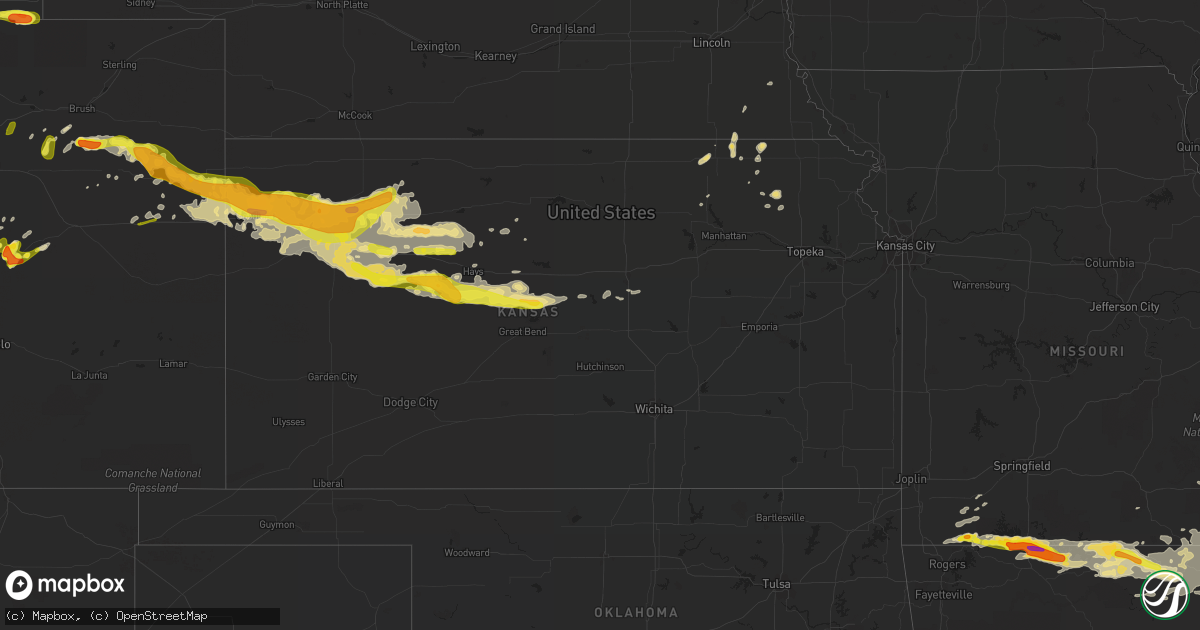
Hail Map in Kansas on May 26, 2017
Get this storm
May 26 map
$229
one time, instant access
Download today. No call, no setup
Keep the $229
Bought the map and want the full workflow? Apply the entire $229 to a subscription within 7 days. None of it is wasted.
Every map, not just this one
This buys you this map. Subscription and you get every map we run, in the markets you choose from a few cities to whole states to nationwide. Plus real-time alerts the moment a storm fires.
Contact data
Name, contact info, occupancy, even credit band for addresses in the footprint. You go from where it hit to who to call.
Become the source they trust
Unlimited branding weather history reports on demand. You already have the documented answer ready for the property owner, and you are the one who showed up with it.
Property data and RoofTrace estimates
Pull up any address you have got, its value and the exact code rules for that jurisdiction, straight from One Click Code. Then RoofTrace estimates the squares, pitch, and roof value, priced the way you price.
Storm reports in Kansas
Kansas
| Date | Description |
|---|---|
| 05/26/20173:13 AM CDT | A local report indicates 1.00 inch wind near SCHOENCHEN |
| 05/26/20173:00 AM CDT | A local report indicates 70 MPH wind near 2 SW ALTON |
| 05/26/20172:49 AM CDT | A local report indicates 1.75 inch wind near CEDAR BLUFF |
| 05/26/20172:35 AM CDT | Delayed report. Large healthy hardwood tree branch snapped off. The base of the branch was approx 6-7 inches in diameter. Photo relayed via social media. Time est fm ra |
| 05/26/20171:53 AM CDT | A local report indicates a tornado near 7 S COLLYER |
| 05/26/20171:20 AM CDT | Zero visibility in blowing dust. Also nickel sized hail. |
| 05/26/201712:45 AM CDT | Relayed via wfo pueblo |
| 05/26/201712:37 AM CDT | A local report indicates 63 MPH wind near 4 NNE HOXIE |
| 05/26/201712:23 AM CDT | A local report indicates 70 MPH wind near ANGELUS |
| 05/26/201712:12 AM CDT | A local report indicates 1.00 inch wind near 7 NE HOXIE |
| 05/25/201711:50 PM CDT | A local report indicates 67 MPH wind near COLBY |
| 05/25/201711:45 PM CDT | Chaser reported wall cloud with debris swirl visible on the ground. |
| 05/25/201711:35 PM CDT | Farmer reported a brief touchdown. Report relayed by sheridan county so. |
| 05/25/201711:01 PM CDT | A local report indicates 2.00 inch wind near 4 N GOODLAND |
| 05/25/201710:55 PM CDT | A local report indicates 2.00 inch wind near GOODLAND |
| 05/25/201710:54 PM CDT | A local report indicates 1.75 inch wind near GOODLAND |
| 05/25/201710:48 PM CDT | Report of estimated wind of 75 to 80 mph. Wind driven hail shattered the back of a car window. |
| 05/25/201710:47 PM CDT | A local report indicates 1.00 inch wind near COLBY |
| 05/25/201710:43 PM CDT | A local report indicates 1.50 inch wind near 2 SSE COLBY |
| 05/25/201710:42 PM CDT | A local report indicates 1.00 inch wind near 4 N COLBY |
| 05/25/201710:36 PM CDT | A local report indicates 1.75 inch wind near COLBY |
| 05/25/201710:33 PM CDT | A local report indicates 1.25 inch wind near 2 SSW COLBY |
| 05/25/201710:32 PM CDT | A local report indicates 1.00 inch wind near 13 NNW EDSON |
| 05/25/201710:19 PM CDT | A local report indicates 1.00 inch wind near 2 WSW LEVANT |
| 05/25/20179:40 PM CDT | Nws employee reports wind gust of 60 mph. Also had large amounts of nickel and dime sized hail. |
| 05/25/20179:30 PM CDT | A local report indicates 1.50 inch wind near 10 NE GOODLAND |
| 05/25/20179:25 PM CDT | A local report indicates 1.50 inch wind near 7 NE GOODLAND |
| 05/25/20179:00 PM CDT | Caused lots of damage to wheat crop |
| 05/25/20177:45 PM CDT | Nws goodland soo reports wind gust of 65 mph. |
| 05/25/20177:45 PM CDT | Nws goodland mic reports 63 mph wind gust. |
| 05/25/20177:45 PM CDT | Nws employee reported wind gust of 60 mph. Also had large amounts of dime sized hail. |
| 05/25/20177:45 PM CDT | Storm spotter reported 1.25 inch diameter hail. |
All States Impacted by Hail Map on May 26, 2017
Cities Impacted by Hail Map on May 26, 2017
- Goodland, KS
- Monument, CO
- Larkspur, CO
- Avon, IL
- Bushnell, IL
- Good Hope, IL
- Prairie City, IL
- Roseville, IL
- Harrison, AR
- Lampe, MO
- Yellville, AR
- Omaha, AR
- Berryville, AR
- Oak Grove, AR
- Green Forest, AR
- Lead Hill, AR
- Blue Eye, MO
- Shell Knob, MO
- Kirbyville, MO
- Hollister, MO
- Ridgedale, MO
- Hanna, WY
- Grinnell, KS
- Eagle Rock, MO
- Seligman, MO
- Cassville, MO
- Washburn, MO
- Hanover, KS
- Waterville, KS
- Marysville, KS
- Bremen, KS
- Attica, IN
- Dana, IL
- Long Point, IL
- Rankin, IL
- Hoopeston, IL
- Rossville, IL
- Burlington, CO
- Jonesboro, AR
- State University, AR
- Summerfield, KS
- Liberty, NE
- Home, KS
- Burchard, NE
- Beattie, KS
- Oketo, KS
- Havensville, KS
- Onaga, KS
- Wiseman, AR
- Viola, AR
- Gepp, AR
- Gassville, AR
- Norfork, AR
- Midway, AR
- Gamaliel, AR
- Bexar, AR
- Glencoe, AR
- Mountain Home, AR
- Dolph, AR
- Clarkridge, AR
- Gainesville, MO
- Calico Rock, AR
- Oakland, AR
- Pontiac, MO
- Cherokee Village, AR
- Salem, AR
- Hardy, AR
- Ash Flat, AR
- Oxford, AR
- Horseshoe Bend, AR
- Bakersfield, MO
- Elizabeth, AR
- Henderson, AR
- Lakeview, AR
- Grover, CO
- Carpenter, WY
- Indianapolis, IN
- Lebanon, IN
- New Ross, IN
- Lizton, IN
- Thorntown, IN
- Pittsboro, IN
- Brownsburg, IN
- New Market, IN
- Zionsville, IN
- Advance, IN
- Darlington, IN
- Whitestown, IN
- Ladoga, IN
- Crawfordsville, IN
- Jamestown, IN
- Colby, KS
- Winona, KS
- Kirk, CO
- Akron, CO
- Lindon, CO
- Woodrow, CO
- Levant, KS
- Saginaw, MN
- Morland, KS
- Selden, KS
- Noblesville, IN
- Alicia, AR
- Walnut Ridge, AR
- Bono, AR
- Lake City, AR
- Cash, AR
- Saffell, AR
- Brookland, AR
- Swifton, AR
- Creve Coeur, IL
- East Peoria, IL
- Peoria, IL
- Milford, IL
- Hoxie, KS
- Gem, KS
- Oakley, KS
- Rexford, KS
- Pine Bluffs, WY
- Kimball, NE
- Bushnell, NE
- Gilman, IL
- Cissna Park, IL
- Alvin, IL
- Loda, IL
- Paxton, IL
- Williamsport, IN
- Chatsworth, IL
- Piper City, IL
- Powhatan, AR
- Black Rock, AR
- Smithville, AR
- Brush, CO
- Pekin, IL
- Deer Creek, IL
- Hanna City, IL
- Morton, IL
- Mapleton, IL
- Glasford, IL
- Washington, IL
- Ramah, CO
- Simla, CO
- Natoma, KS
- Fairbury, IL
- Strawn, IL
- Roberts, IL
- Colfax, IL
- Cropsey, IL
- Sibley, IL
- Melvin, IL
- Wilkinson, IN
- Markleville, IN
- Greenfield, IN
- Mellott, IN
- New Richmond, IN
- Covington, IN
- Henning, IL
- Veedersburg, IN
- Wingate, IN
- Waynetown, IN
- State Line, IN
- Danville, IL
- Westpoint, IN
- Potomac, IL
- Bismarck, IL
- Newtown, IN
- Hillsboro, IN
- West Lebanon, IN
- Corning, AR
- Calhan, CO
- Peyton, CO
- Byers, CO
- Quinter, KS
- Gove, KS
- Melbourne, AR
- Baileyville, KS
- Seneca, KS
- Palmer Lake, CO
- Franktown, CO
- Fort Morgan, CO
- Hereford, CO
- Sheridan, IN
- Ravenden, AR
- Imboden, AR
- Pocahontas, AR
- Ravenden Springs, AR
- Buckley, IL
- Crane, MO
- Aurora, MO
- Akron, IN
- Claypool, IN
- Idalia, CO
- Edson, KS
- Saint Francis, KS
- Kanorado, KS
- Brewster, KS
- Elbert, CO
- Neelyville, MO
- Fowler, IN
- Oxford, IN
- West Lafayette, IN
- Brookston, IN
- Otterbein, IN
- Ogallah, KS
- Wakeeney, KS
- Ellis, KS
- Mammoth Spring, AR
- Canton, IL
- Rawlins, WY
- Cheyenne, WY
- Homestead, FL
- Bowen, IL
- Plymouth, IL
- Augusta, IL
- Carthage, IL
- Smithfield, IL
- Sciota, IL
- Ellisville, IL
- Paragould, AR
- McCracken, KS
- Aurora, CO
- Kingston Mines, IL
- Oxly, MO
- Doniphan, MO
- Carr, CO
- Hays, KS
- London Mills, IL
- Smithshire, IL
- Saint Augustine, IL
- Blandinsville, IL
- Raritan, IL
- Joes, CO
- Success, AR
- Burns, WY
- Kiowa, CO
- Pollard, AR
- Piggott, AR
- Russell, KS
- Grainfield, KS
- Soldier, KS
- Kennett, MO
- Holcomb, MO
- Middletown, IN
- Henryetta, OK
- Collyer, KS
- Brookston, MN
- La Crosse, KS
- Bison, KS
- Pfeifer, KS
- Liebenthal, KS
- Otis, KS
- Thayer, MO
- Cope, CO
- Forrest, IL
- Cullom, IL
- Saunemin, IL
- Park, KS
- Granite Canon, WY
- Wideman, AR
- Peel, AR
- Cotter, AR
- Franklin, AR
- Bull Shoals, AR
- Flippin, AR
- Camp, AR
- Cedarcreek, MO
- Theodosia, MO
- Golden, MO
- Wamsutter, WY
- Checotah, OK
- Myrtle, MO
- Couch, MO
- Gatewood, MO
- Lexington, IL
- Hill City, KS
- Fountaintown, IN
- Marshall, IN
- Cicero, IN
- Arcadia, IN
- Palco, KS
- Holton, KS
- Burket, IN
- Mentone, IN
- Silver Lake, IN
- Monument, KS
- Elizabeth, CO
- Cord, AR
- Olmitz, KS
- Hoisington, KS
- Schoenchen, KS
- Brownell, KS
- Ransom, KS
- Claflin, KS
- Utica, KS
- Holyrood, KS
- West Burlington, IA
- Danville, IA
- Burlington, IA
- Middletown, IA
- Farmington, IL
- Fairview, IL
- Plainville, KS
- Penokee, KS
- Aurora, MN
- Yuma, CO
- Gorham, KS
- Victoria, KS
- Bethune, CO
- Jennings, KS
- Randolph, KS
- Albin, WY
- Spooner, WI
- Hibbing, MN
- Leonardville, KS
- Purdy, MO
- Monett, MO
- Sheldon, IL
- Sage, AR
- Flanagan, IL
- Graymont, IL
- Gridley, IL
- Delaplaine, AR
- Biggers, AR
- Matheson, CO
- Trivoli, IL
- Kanopolis, KS
- Ellsworth, KS
- Assaria, KS
- Earl Park, IN
- Barnum, MN
- West Plains, MO
- Koshkonong, MO
- Hillsdale, WY
- Winona, MO
- Gypsum, KS
- Pomona, MO
- Roggen, CO
- Pengilly, MN
- Protem, MO
- Wiggins, CO
- Sidney, AR
- Waldo, KS
- Pontiac, IL
- Colfax, IN
- Fortville, IN
- Vona, CO
- Alton, MO
- Caulfield, MO
- Pineville, MO
- Warm Springs, AR
- Sturkie, AR
- Eureka Springs, AR
- Williford, AR
- Poughkeepsie, AR
- Moody, MO
- Evening Shade, AR
- Alpena, AR
- Maynard, AR
- Udall, MO
- Leachville, AR
- Monette, AR
- Cook, NE
- Brock, NE
- Carmel, IN
- Chenoa, IL
- North Salem, IN
- Danville, IN
- Romney, IN
- Ambia, IN
- Collison, IL
- Vermillion, KS
- Flagler, CO
- Kirklin, IN
- Anton, CO
- Linden, IN
- Verona, MO
- Rock Springs, WY
- Stratton, CO
- Bogue, KS
- Dresden, KS
- Lorraine, KS
- Clayton, KS
- Exeter, MO
- Seibert, CO
- Lewiston, NE
- Steinauer, NE
- Lindsborg, KS
- Falun, KS
- Troy, TN
- Hornbeak, TN
- Centralia, KS
- Portageville, MO
- Wardell, MO
- Rutland, IL
- Kingman, IN
- Boynton, OK
- Peoria Heights, IL
- Lenora, KS
- Council Hill, OK
- Morris, OK
- Brookville, KS
- Hornersville, MO
- Arbyrd, MO
- Genoa, CO
- Fe Warren Afb, WY
- Nunn, CO
- Wray, CO
- Keenesburg, CO
- Colorado Springs, CO


