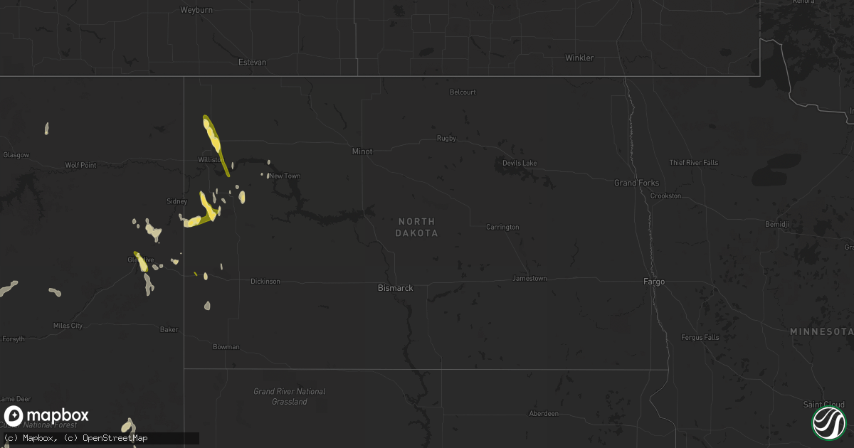
Hail Map in North Dakota on May 25, 2023
Get this storm
May 25 map
$229
one time, instant access
Download today. No call, no setup
Keep the $229
Bought the map and want the full workflow? Apply the entire $229 to a subscription within 7 days. None of it is wasted.
Every map, not just this one
This buys you this map. Subscription and you get every map we run, in the markets you choose from a few cities to whole states to nationwide. Plus real-time alerts the moment a storm fires.
Contact data
Name, contact info, occupancy, even credit band for addresses in the footprint. You go from where it hit to who to call.
Become the source they trust
Unlimited branding weather history reports on demand. You already have the documented answer ready for the property owner, and you are the one who showed up with it.
Property data and RoofTrace estimates
Pull up any address you have got, its value and the exact code rules for that jurisdiction, straight from One Click Code. Then RoofTrace estimates the squares, pitch, and roof value, priced the way you price.
Storm reports in North Dakota
North Dakota
| Date | Description |
|---|---|
| 05/25/20236:59 PM CDT | Hail lasted 15 minutes... With 0.56 inches of rain. Report via social media. |
| 05/24/20238:45 PM CDT | Delayed report from evening of 5/25. Ground was covered in hail... With the largest up to the size of quarters. |
| 05/24/20238:40 PM CDT | A local report indicates 1.00 inch wind near HOMESTEADERS GAP |
| 05/24/20238:18 PM CDT | Delayed report from evening of 5/25 from social media. Photo of hail close to the size of a half dollar. Time estimated from radar. |
| 05/24/20238:00 PM CDT | Delayed report from evening of 5/25... From social media. Photo of hail about to the size of a half dollar. |
| 05/24/20237:57 PM CDT | A local report indicates 1.25 inch wind near 8 E SATHER DAM |
| 05/24/20237:00 PM CDT | A local report indicates 1.50 inch wind near 14 NNW WATFORD CITY |
All States Impacted by Hail Map on May 25, 2023
Cities Impacted by Hail Map on May 25, 2023
- Willow, OK
- Eldorado, TX
- Sonora, TX
- Mertzon, TX
- Rocksprings, TX
- Garden City, TX
- Junction, TX
- Okeechobee, FL
- Raton, NM
- Cimarron, NM
- Canon City, CO
- Florence, CO
- Lake George, CO
- Coal Creek, CO
- Riverton, WY
- Dillon, CO
- Coalmont, CO
- Rawlins, WY
- Thermopolis, WY
- Encampment, WY
- Jeffrey City, WY
- Trinidad, CO
- Wetmore, CO
- Saratoga, WY
- Bairoil, WY
- Walsenburg, CO
- Sinclair, WY
- Meeteetse, WY
- Jefferson, CO
- Rye, CO
- Silver Plume, CO
- Worland, WY
- Florissant, CO
- Walden, CO
- Shoshoni, WY
- Georgetown, CO
- Aguilar, CO
- Bailey, CO
- Parshall, CO
- Grant, CO
- Pueblo, CO
- Beulah, CO
- Hot Sulphur Springs, CO
- Guffey, CO
- Powell, WY
- Crowheart, WY
- Arapahoe, WY
- Hudson, WY
- Kinnear, WY
- Lander, WY
- Dubois, WY
- Cody, WY
- Fort Washakie, WY
- Pavillion, WY
- Bruneau, ID
- Littleton, CO
- Lone Tree, CO
- Englewood, CO
- Model, CO
- Seymour, TX
- Holliday, TX
- Duke, OK
- Marfa, TX
- Branson, CO
- Gould, OK
- Greybull, WY
- Alzada, MT
- Buffalo, WY
- Two Dot, MT
- Mangum, OK
- Kaycee, WY
- Laramie, WY
- Valentine, TX
- Loxahatchee, FL
- Clewiston, FL
- Inkom, ID
- Pocatello, ID
- Livingston, MT
- Boyes, MT
- Pembroke Pines, FL
- Hollywood, FL
- Fort Lauderdale, FL
- North Bend, NE
- Arco, ID
- Weston, WY
- Hammond, MT
- Camp Wood, TX
- Leakey, TX
- Opa Locka, FL
- Miami, FL
- Labelle, FL
- Moore, ID
- Miami Gardens, FL
- Hoxie, KS
- Barksdale, TX
- Bozeman, MT
- Manhattan, MT
- Lavina, MT
- Ordway, CO
- Ocate, NM
- Wagon Mound, NM
- Olney Springs, CO
- Sentinel Butte, ND
- Fountain, CO
- Colorado Springs, CO
- Conchas Dam, NM
- Tucumcari, NM
- Mosquero, NM
- Williston, ND
- Zahl, ND
- Alamo, ND
- San Jon, NM
- Glendive, MT
- Amistad, NM
- Sedan, NM
- Dalhart, TX
- Texline, TX
- Roundup, MT
- Parks, NE
- Grady, NM
- Wendover, UT
- Watford City, ND
- Garryowen, MT
- Yuma, CO
- Rhame, ND
- Winnett, MT
- Keene, ND
- Twin Falls, ID
- Oakley, ID
- Wibaux, MT
- Grass Range, MT
- Lewistown, MT
- Forest Grove, MT
- Matheson, CO
- Dayton, WY
- Parkman, WY
- Decker, MT
- Sheridan, WY
- Custer, MT
- Hardin, MT
- Musselshell, MT
- Cartwright, ND
- Deer Trail, CO
- Byers, CO
- Fort Morgan, CO
- Bosler, WY
- Alexander, ND
- Idalia, CO
- Judith Gap, MT
- Buffalo, MT
- Medora, ND
- Aurora, CO
- Arnegard, ND
- New Town, ND
- Bird City, KS
- Grenville, NM
- Ramah, CO
- Epping, ND
- Wray, CO
- Vernon, CO
- Big Timber, MT
- Denver, CO
- Stanley, ND
- Dugway, UT
- Mosby, MT
- American Falls, ID
- Wyola, MT
- Platteville, CO
- Howard, CO
- Clayton, NM
- Granite Canon, WY
- Karval, CO
- Commerce City, CO
- Bliss, ID
- Garrett, WY
- Ingomar, MT
- Broadview, NM
- Texico, NM
- Bovina, TX
- Farwell, TX
- Fall River Mills, CA
- Forsyth, MT
- Malta, MT
- Sidney, MT
- Savage, MT
- Benkelman, NE
- Bloomfield, MT
- Fort Peck, MT
- Nashua, MT
- Brush, CO
- Richey, MT
- Chester, CA
- Snyder, CO
- Kinsey, MT
- Corning, CA
- Clovis, NM
- Santa Rosa, NM
- Cuervo, NM
- Tulia, TX
- Oberlin, KS
- Fort Sumner, NM
- Taiban, NM
- Bard, NM
- Akron, CO
- Elida, NM
- Grassy Butte, ND
- Roswell, NM
- Mcalister, NM
- Hale Center, TX
- Stratton, NE
- Littlefield, TX
- Abernathy, TX
- Anton, TX
- Max, NE
- Haigler, NE
- Muleshoe, TX


