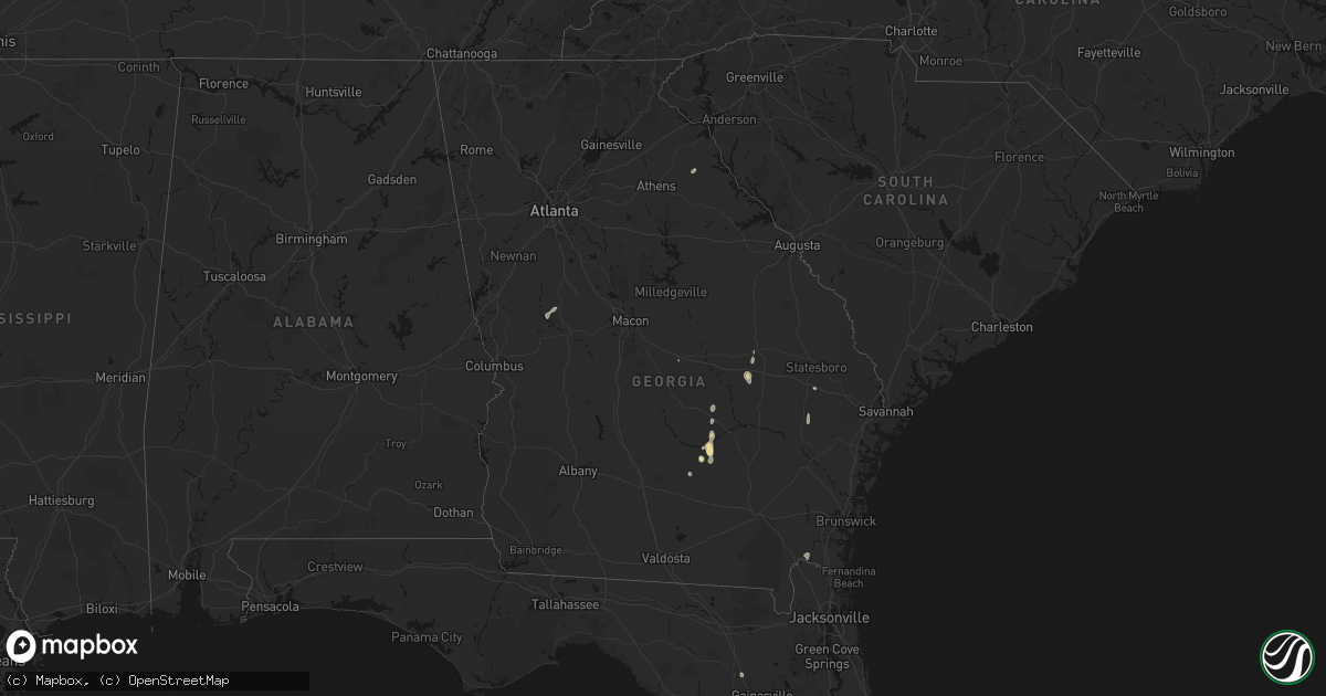
Hail Map in Georgia on May 24, 2026
Get this storm
May 24 map
$229
one time, instant access
Download today. No call, no setup
Keep the $229
Bought the map and want the full workflow? Apply the entire $229 to a subscription within 7 days. None of it is wasted.
Every map, not just this one
This buys you this map. Subscription and you get every map we run, in the markets you choose from a few cities to whole states to nationwide. Plus real-time alerts the moment a storm fires.
Contact data
Name, contact info, occupancy, even credit band for addresses in the footprint. You go from where it hit to who to call.
Become the source they trust
Unlimited branding weather history reports on demand. You already have the documented answer ready for the property owner, and you are the one who showed up with it.
Property data and RoofTrace estimates
Pull up any address you have got, its value and the exact code rules for that jurisdiction, straight from One Click Code. Then RoofTrace estimates the squares, pitch, and roof value, priced the way you price.
Storm reports in Georgia
Georgia
| Date | Description |
|---|---|
| 05/24/20266:35 PM CDT | Tree down at hwy 80 and hwy 129. |
| 05/24/20265:30 PM CDT | A tree downed blocking the road at the intersection of tremont road and brown road. |
| 05/24/20265:20 PM CDT | A tree downed blocking the road at the intersection of cemetery road and sirmons road. |
| 05/24/20265:20 PM CDT | A tree downed blocking the road in hatley east of hwy 90. |
| 05/24/20265:20 PM CDT | Tree down on power lines on tommy harrell rd. Time estimated via radar. |
| 05/24/20265:10 PM CDT | Tree down along highway 112 near rebecca. |
| 05/24/20264:54 PM CDT | Tree down along highway 31 south near mile marker 6. |
| 05/24/20264:41 PM CDT | Tree down on james drive. |
| 05/24/20264:02 PM CDT | Several trees down on graves highway west of dawson. |
| 05/24/20263:59 PM CDT | Several trees reported down south of shellman. |
| 05/24/20263:20 PM CDT | Tree down on antioch road sw of adel. Time estimated by radar. |
| 05/24/20263:03 PM CDT | There were a couple of reports of trees down in baker county. |
| 05/24/20262:45 PM CDT | At least 1 tree down along minshew road ne partially blocking the roadway. |
| 05/24/20262:40 PM CDT | At least 1 tree down along big texas valley road nw partially blocking the road. |
| 05/24/20262:30 PM CDT | There were 3 small trees blown over hitting a vehicle. No injuries. |
| 05/24/20262:30 PM CDT | At least 1 tree down near the intersection of green view road sw and horseleg creek rd sw blocking the roadway. |
All States Impacted by Hail Map on May 24, 2026
Cities Impacted by Hail Map on May 24, 2026
- Graettinger, IA
- Weatherford, OK
- Custer City, OK
- Clinton, OK
- Thomas, OK
- Arapaho, OK
- Putnam, OK
- Thomaston, GA
- Armstrong, TX
- Kerens, TX
- Justin, TX
- Crandall, TX
- Scurry, TX
- Kemp, TX
- Folkston, GA
- Kaufman, TX
- Hilliard, FL
- Fort Worth, TX
- Haslet, TX
- Mabank, TX
- Seagoville, TX
- Lyford, TX
- Ferris, TX
- North Richland Hills, TX
- Raymondville, TX
- San Perlita, TX
- Bedford, TX
- Hurst, TX
- Colleyville, TX
- Rhome, TX
- Punta Gorda, FL
- Duluth, MN
- Haltom City, TX
- Eustace, TX
- Comanche, TX
- Rosser, TX
- Euless, TX
- Desoto, TX
- Duncanville, TX
- Arlington, TX
- Lancaster, TX
- Grand Prairie, TX
- Red Oak, TX
- San Benito, TX
- Decatur, TX
- Lipan, TX
- Stephenville, TX
- Athens, TX
- Kathleen, FL
- Lakeland, FL
- Wagner, SD
- Delmont, SD
- Dallas, TX
- Glennville, GA
- Ambrose, GA
- Sacred Heart, MN
- Cedar Hill, TX
- Los Fresnos, TX
- Lake Lillian, MN
- Olivia, MN
- Dade City, FL
- Larue, TX
- Murchison, TX
- Hector, MN
- Cosmos, MN
- Bird Island, MN
- Tripp, SD
- Avon, SD
- Renville, MN
- Zephyrhills, FL
- Alvord, TX
- Alachua, FL
- Broxton, GA
- Irving, TX
- Buffalo Lake, MN
- Denton, GA
- Sunset, TX
- Danube, MN
- Wray, GA
- Granbury, TX
- Cresson, TX
- Stollings, WV
- Switzer, WV
- Logan, WV
- Chauncey, WV
- Junction, TX
- Redwood Falls, MN
- Lumber City, GA
- Hazlehurst, GA
- Lyburn, WV
- Yolyn, WV
- Weatherford, TX
- Harper, TX
- Pembroke, GA
- Statesboro, GA
- Palestine, TX
- Montalba, TX
- Kaylor, SD
- Pipestone, MN
- Stewart, MN
- Forestburg, TX
- Alamo, GA
- Aledo, TX
- Arlington, MN
- Gaylord, MN
- Canton, TX
- Franklin, MN
- McRae Helena, GA
- Holland, MN
- Scotland, SD
- Olivet, SD
- Mountain Home, TX
- Bowie, TX
- Gibbon, MN
- Winthrop, MN
- Fairfax, MN
- Edgerton, MN
- Woodstock, MN
- Gorman, TX
- Desdemona, TX
- Bushnell, FL
- Freeman, SD
- Emery, SD
- Menno, SD
- Lesterville, SD
- Soperton, GA
- Vidalia, GA
- Canistota, SD
- Ranger, TX
- Dublin, TX
- Brooksville, FL
- Fredericksburg, TX
- Eden, TX
- Willmar, MN
- Brownton, MN
- Raymond, MN
- Bridgewater, SD
- Chambers, NE
- Tarrytown, GA
- Marion, SD
- Carbon, TX
- New Ulm, MN
- Belfry, KY
- Sidney, KY
- Forest Hills, KY
- South Williamson, KY
- Williamson, WV
- Lafayette, MN
- Nicollet, MN
- Saint Peter, MN
- Kerkhoven, MN
- Santo, TX
- Eastland, TX
- Ewing, NE
- Dudley, GA
- Swainsboro, GA
- Humboldt, SD
- Le Sueur, MN
- Perrin, TX
- Morriston, FL
- Palo Pinto, TX
- Montrose, SD
- Jasper, MN
- Gordon, TX
- Mingus, TX
- Le Center, MN
- Strawn, TX
- Courtland, MN
- Fulda, MN
- Iona, MN
- Graford, TX
- Lake Wilson, MN
- Tyndall, SD
- Lake Crystal, MN
- Hanska, MN
- Worthington, MN
- Slayton, MN
- Carlton, GA
- Bowman, GA
- Egan, SD
- Mankato, MN
- Utica, SD
- Flandreau, SD
- Hartford, SD
- Chandler, MN
- Leota, MN
- Hardwick, MN
- Clearwater, NE
- Ruthton, MN
- Williston, FL
- Balaton, MN
- Reading, MN
- Kasota, MN
- Gregory, SD
- Graham, TX
- Elberton, GA
- Yankton, SD
- Centerville, SD
- Burke, SD
- Archer, FL
- Micanopy, FL
- Eagle Lake, MN
- Medina, TX
- Beresford, SD
- Mission Hill, SD
- Irene, SD
- Volin, SD
- Brewster, MN
- High Springs, FL
- Mineral Wells, TX
- Crockett, TX
- Wakonda, SD
- Vermillion, SD
- Cisco, TX
- Gustine, TX
- Hurley, SD
- Bandera, TX
- Santa Anna, TX
- Parker, SD
- Hico, TX
- Early, TX
- Cross Plains, TX
- Burkett, TX
- Brownwood, TX
- Bangs, TX
- Chancellor, SD
- Alcester, SD
- Coleman, TX
- Lennox, SD
- Tea, SD
- Harrisburg, SD
- Worthing, SD
- Sioux Falls, SD
- Monroe, SD
- Canton, SD
- Larchwood, IA
- Inwood, IA
- Mullin, TX
- Alvord, IA
- Goldthwaite, TX
- Priddy, TX
- Davis, SD
- Brandon, SD
- Valley Springs, SD
- Richland Springs, TX
- Doon, IA
- Hull, IA
- San Saba, TX
- Rock Rapids, IA
- Rochelle, TX
- Boyden, IA
- Lester, IA
- Sheldon, IA
- George, IA
- Peterson, IA
- Lometa, TX
- Ashton, IA
- Sanborn, IA
- Rising Star, TX
- Hartley, IA
- May, TX
- Henderson, MN
- Green Isle, MN


