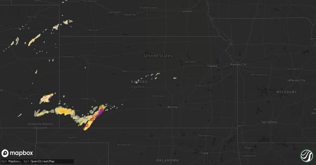
Hail Map in Kansas on May 24, 2015
Get this storm
May 24 map
$229
one time, instant access
Download today. No call, no setup
Keep the $229
Bought the map and want the full workflow? Apply the entire $229 to a subscription within 7 days. None of it is wasted.
Every map, not just this one
This buys you this map. Subscription and you get every map we run, in the markets you choose from a few cities to whole states to nationwide. Plus real-time alerts the moment a storm fires.
Contact data
Name, contact info, occupancy, even credit band for addresses in the footprint. You go from where it hit to who to call.
Become the source they trust
Unlimited branding weather history reports on demand. You already have the documented answer ready for the property owner, and you are the one who showed up with it.
Property data and RoofTrace estimates
Pull up any address you have got, its value and the exact code rules for that jurisdiction, straight from One Click Code. Then RoofTrace estimates the squares, pitch, and roof value, priced the way you price.
Storm reports in Kansas
Kansas
| Date | Description |
|---|---|
| 05/24/20151:40 AM CDT | A local report indicates 1.00 inch wind near 2 NE THE HAGGARD ELEV |
| 05/24/201512:41 AM CDT | A local report indicates a tornado near 2 E FT. DODGE |
| 05/24/201512:37 AM CDT | Reported a tornado on the ground at this time. |
| 05/24/201512:35 AM CDT | A local report indicates a tornado near 5 S DODGE CITY |
| 05/24/201512:30 AM CDT | A local report indicates a tornado near 6 S DODGE CITY |
| 05/24/201512:30 AM CDT | A local report indicates a tornado near 6 N DODGE CITY |
| 05/24/201512:20 AM CDT | A local report indicates a tornado near 3 S FT. DODGE |
| 05/24/201512:02 AM CDT | Probable tornado damage at a residence on the east side of ensign at y road. |
| 05/24/201512:01 AM CDT | A local report indicates a tornado near 5 N PLAINS CITY |
| 05/23/201511:58 PM CDT | A local report indicates a tornado near 3 N PLAINS CITY |
| 05/23/201511:56 PM CDT | Storm chaser reports that a tornado hit a wind turbine. |
| 05/23/201511:55 PM CDT | A local report indicates a tornado near 5 N KISMET |
| 05/23/201511:47 PM CDT | Power poles downed. Possible tornado damage. |
| 05/23/201511:41 PM CDT | A local report indicates a tornado near 4 N KISMET |
| 05/23/201511:30 PM CDT | Chaser reported wedge tornado in progress |
| 05/23/201511:28 PM CDT | Operator observed a large tornado. |
| 05/23/201511:17 PM CDT | Large wedge tornado ongoing. Hard to see as tornado is occurring within fog. |
| 05/23/201511:15 PM CDT | Power poles blown down. Possible tornado damage. |
| 05/23/201511:15 PM CDT | Large wedge tornado in progress. |
| 05/23/201511:00 PM CDT | Huge tornado seen with spotter hearing a roaring sound. |
| 05/23/201510:54 PM CDT | A local report indicates a tornado near 6 NE MISSLER |
| 05/23/201510:45 PM CDT | Large... Wedge tornado on the ground |
| 05/23/201510:41 PM CDT | A local report indicates 1.75 inch wind near 8 SE COPELAND |
| 05/23/201510:24 PM CDT | Spotter reported a large wedge on the ground. |
| 05/23/201510:22 PM CDT | A local report indicates a tornado near 8 NE MISSLER |
| 05/23/201510:09 PM CDT | A local report indicates a tornado near 4 N PLAINS CITY |
| 05/23/201510:05 PM CDT | A local report indicates a tornado near 3 NW PLAINS CITY |
| 05/23/201510:00 PM CDT | Barn heavily damaged at farm |
| 05/23/20159:54 PM CDT | Spotter reported a cone tornado at this location. |
| 05/23/20159:27 PM CDT | A local report indicates 1.00 inch wind near 3 ENE BIG BOW |
| 05/23/20159:12 PM CDT | A local report indicates 1.00 inch wind near 4 ENE BIG BOW |
| 05/23/20159:12 PM CDT | A local report indicates 1.25 inch wind near 2 W KISMET |
| 05/23/20159:01 PM CDT | Rope tornado on the ground briefly 2 minutes ago. |
| 05/23/20158:59 PM CDT | Spotter reported a short lived rope tornado. |
| 05/23/20158:58 PM CDT | A local report indicates 1.00 inch wind near 5 NW BIG BOW |
| 05/23/20158:39 PM CDT | A local report indicates 1.25 inch wind near LIBERAL |
| 05/23/20158:33 PM CDT | A local report indicates 3.00 inch wind near 2 NE LIBERAL |
| 05/23/20158:20 PM CDT | A local report indicates 1.25 inch wind near LIBERAL |
| 05/23/20158:09 PM CDT | A local report indicates 1.50 inch wind near 3 SW LIBERAL |
| 05/23/20158:07 PM CDT | A local report indicates 1.75 inch wind near 3 N MANTER |
All States Impacted by Hail Map on May 24, 2015
Cities Impacted by Hail Map on May 24, 2015
- Lilbourn, MO
- New Madrid, MO
- Ellsworth, KS
- Ogallala, NE
- Wray, CO
- Whitman, NE
- Walsh, CO
- Johnson, KS
- Manter, KS
- Ulysses, KS
- Kismet, KS
- Satanta, KS
- Stanton, TX
- Big Spring, TX
- Ellisville, MS
- Plains, KS
- Kit Carson, CO
- Wild Horse, CO
- Montezuma, KS
- Liberal, KS
- Hugoton, KS
- Burlison, TN
- Drummonds, TN
- Hoisington, KS
- Great Bend, KS
- Bucklin, KS
- Andrews, TX
- Crawford, NE
- Cope, CO
- Midland, TX
- Stratton, CO
- Merriman, NE
- Oakley, KS
- Lamar, CO
- Turpin, OK
- Del Rio, TX
- Holly, CO
- Akron, CO
- Otis, CO
- Claflin, KS
- Fort Morgan, CO
- Syracuse, KS
- Venango, NE
- Champion, NE
- Carrollton, AL
- Cody, NE
- Wilson, KS
- Knott, TX
- Moscow, KS
- Hemingford, NE
- Copeland, KS
- Byers, CO
- Deer Trail, CO
- Garden City, TX
- Sublette, KS
- Coahoma, TX
- Tarzan, TX
- Tyrone, OK
- Ensign, KS
- Cimarron, KS
- Meade, KS
- Dodge City, KS
- Livingston, AL
- Burlington, CO
- Benkelman, NE
- Enders, NE
- Hoxie, AR
- Eutaw, AL
- Anton, CO
- Lindon, CO
- Yuma, CO
- Ford, KS
- Spearville, KS
- Gordon, NE
- Springfield, CO
- Brookville, KS
- Seibert, CO
- Fairfield, ID
- Lenorah, TX
- Millington, TN
- Ingalls, KS
- Idalia, CO
- Imperial, NE
- Walnut Ridge, AR
- Biggers, AR
- Pocahontas, AR
- Tonasket, WA
- Two Buttes, CO
- Brule, NE
- Natchitoches, LA
- Dumas, AR
- Bennett, CO
- Pritchett, CO
- Las Animas, CO
- Haswell, CO
- Munford, TN
- Henning, TN
- Brighton, TN
- Harrison, NE
- Flagler, CO
- Wright, KS
- Kinsley, KS
- Bethune, CO
- Branson, CO
- Granada, CO
- Geneseo, KS
- Marquette, KS
- Hillrose, CO
- Gypsum, KS
- Hope, KS
- Whatley, AL
- Franklin, AL
- Brush, CO
- Vona, CO
- Doniphan, MO
- Oxly, MO
- Holyoke, CO
- Ackerly, TX
- Benton, MS
- Bentonia, MS
- Fowler, KS


