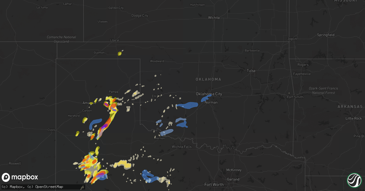
Hail Map in Oklahoma on May 23, 2020
Get this storm
May 23 map
$229
one time, instant access
Download today. No call, no setup
Keep the $229
Bought the map and want the full workflow? Apply the entire $229 to a subscription within 7 days. None of it is wasted.
Every map, not just this one
This buys you this map. Subscription and you get every map we run, in the markets you choose from a few cities to whole states to nationwide. Plus real-time alerts the moment a storm fires.
Contact data
Name, contact info, occupancy, even credit band for addresses in the footprint. You go from where it hit to who to call.
Become the source they trust
Unlimited branding weather history reports on demand. You already have the documented answer ready for the property owner, and you are the one who showed up with it.
Property data and RoofTrace estimates
Pull up any address you have got, its value and the exact code rules for that jurisdiction, straight from One Click Code. Then RoofTrace estimates the squares, pitch, and roof value, priced the way you price.
Storm reports in Oklahoma
Oklahoma
| Date | Description |
|---|---|
| 05/23/20206:40 PM CDT | A local report indicates 1.00 inch wind near BALKO |
| 05/23/20207:57 AM CDT | At 1257 AM CDT, a severe thunderstorm was located near Lockett, moving east at 30 mph. HAZARD...60 mph wind gusts and quarter size hail. SOURCE...Radar indicated. IMPACT...Hail damage to vehicles is expected. Expect wind damage to roofs, siding, and trees. Locations impacted include... Vernon, Davidson, Oklaunion, Lockett and Harrold. |
| 05/23/20207:53 AM CDT | At 1253 AM CDT, a severe thunderstorm was located near Morgan Springs, or 13 miles southeast of Poteau, moving east at 25 mph. HAZARD...60 mph wind gusts and quarter size hail. SOURCE...Radar indicated. IMPACT...Hail damage to vehicles is expected. Expect wind damage to roofs, siding, and trees. Locations impacted include... Bates... |
| 05/23/20207:46 AM CDT | At 1246 AM CDT, a severe thunderstorm was located 8 miles northeast of Broken Bow, or 16 miles west of De Queen, moving east at 35 mph. HAZARD...60 mph wind gusts and quarter size hail. SOURCE...Radar indicated. IMPACT...Hail damage to vehicles is expected. Expect wind damage to roofs, siding, and trees. Locations impacted include... De Queen, Dierks, Umpire, Gillham, Athens, Muddy Fork, Lebanon, Eagletown, Burg, Hochatown, Geneva and West Line. |
| 05/23/20207:31 AM CDT | At 1230 AM CDT, severe thunderstorms were located along a line extending west of Grayback to near Mabelle and Lake Kemp, moving east at 35 mph. HAZARD...Ping pong ball size hail and 60 mph wind gusts. SOURCE...Radar indicated. IMPACT...People and animals outdoors will be injured. Expect hail damage to roofs, siding, windows, and vehicles. Expect wind damage to roofs, siding, and trees. Locations impacted include... Wichita Falls, Burkburnett, Archer City, Iowa Park, Electra, Holliday, Scotland, Windthorst, Megargel, Sheppard AFB, Lake Diversion, Dundee, Westover, Lake Kemp, Mabelle, Mankins, Lake Kickapoo, Grayback, southwestern Lake Arrowhead and Lakeside City. |
| 05/23/20207:13 AM CDT | At 1213 AM CDT, a severe thunderstorm was located over Kinta, moving east at 25 mph. HAZARD...60 mph wind gusts and half dollar size hail. SOURCE...Radar indicated. IMPACT...Hail damage to vehicles is expected. Expect wind damage to roofs, siding, and trees. Locations in or near the path include... Mccurtain... Bokoshe... Kinta... Mc Curtain... Lequire... Milton... Lewisville... |
| 05/23/20206:57 AM CDT | At 1157 PM CDT, severe thunderstorms were located along a line extending from 5 miles southwest of Okarche to 6 miles northwest of Duncan, moving east at 55 mph. HAZARD...60 mph wind gusts and penny size hail. SOURCE...Radar indicated. IMPACT...Expect damage to roofs, siding, and trees. Locations impacted include... Oklahoma City, Norman, Edmond, Moore, Midwest City, Duncan, Del City, El Reno, Chickasha, Newcastle, Blanchard, Pauls Valley, Purcell, Marlow, Yukon, Bethany, Mustang, Choctaw, Warr Acres and The Village. |
| 05/23/20206:22 AM CDT | At 1122 PM CDT, severe thunderstorms were located along a line extending from 7 miles north of Eakly to 3 miles southeast of Faxon, moving east at 30 mph. HAZARD...60 mph wind gusts and quarter size hail. SOURCE...Radar indicated. IMPACT...Hail damage to vehicles is expected. Expect wind damage to roofs, siding, and trees. Locations impacted include... Lawton, Duncan, El Reno, Chickasha, Anadarko, Marlow, Walters, Hinton, Cache, Elgin, Carnegie, Comanche, Union City, Minco, Apache, Geronimo, Rush Springs, Fletcher, Cyril and Sterling. |
| 05/23/20206:09 AM CDT | At 1109 PM CDT, a severe thunderstorm was located near Fort Cobb Reservoir, moving east at 30 mph. HAZARD...60 mph wind gusts and quarter size hail. SOURCE...Radar indicated. IMPACT...Hail damage to vehicles is expected. Expect wind damage to roofs, siding, and trees. Locations impacted include... Weatherford, Anadarko, Hinton, Carnegie, Geary, Hydro, Mountain View, Binger, Fort Cobb, Calumet, Corn, Eakly, Gracemont, Lookeba, Colony, Bridgeport, Cogar, Alfalfa, Fort Cobb Reservoir and Albert. |
| 05/23/20206:03 AM CDT | At 1103 PM CDT, a severe thunderstorm was located near Indiahoma, moving east at 30 mph. HAZARD...60 mph wind gusts and quarter size hail. SOURCE...Trained weather spotters. IMPACT...Hail damage to vehicles is expected. Expect wind damage to roofs, siding, and trees. Locations impacted include... Lawton, Cache, Geronimo, Medicine Park, Indiahoma, Faxon, Fort Sill, Meers, Lake Ellsworth, Lake Lawtonka and Wichita Mountains Wildlife Refuge. |
| 05/23/20205:08 AM CDT | At 1008 PM CDT, a severe thunderstorm was located near Fargo, moving northeast at 30 mph. HAZARD...60 mph wind gusts and quarter size hail. SOURCE...Radar indicated. IMPACT...Hail damage to vehicles is expected. Expect wind damage to roofs, siding, and trees. Locations impacted include... Vernon, Frederick, Davidson, Manitou, Hollister, Loveland and Fargo. |
| 05/23/20204:56 AM CDT | At 954 PM CDT, a severe thunderstorm was located near Altus, moving northeast at 30 mph. HAZARD...60 mph wind gusts and quarter size hail. SOURCE...Radar indicated. IMPACT...Hail damage to vehicles is expected. Expect wind damage to roofs, siding, and trees. Locations impacted include... Altus, Hobart, Granite, Snyder, Sentinel, Tipton, Blair, Lone Wolf, Mountain Park, Indiahoma, Roosevelt, Manitou, Martha, Headrick, Friendship, Cooperton, Altus Air Force Base, Tom Steed Reservoir, Warren and Humphreys. |
| 05/23/20204:20 AM CDT | At 919 PM CDT, severe thunderstorms were located along a line extending from 7 miles south of Lockett to 4 miles southeast of Goree, moving east at 40 mph. HAZARD...60 mph wind gusts and nickel size hail. SOURCE...Radar indicated. IMPACT...Expect damage to roofs, siding, and trees. Locations impacted include... Vernon, Frederick, Seymour, Munday, Davidson, Goree, Megargel, Red Springs, Lake Diversion, Westover, Harrold, Bomarton, Lockett, Lake Kemp, Mabelle, Vera, Oklaunion, Grayback, Thalia and Rayland. |
| 05/23/20204:08 AM CDT | At 908 PM CDT, a severe thunderstorm was located near Medicine Mound, moving northeast at 45 mph. HAZARD...60 mph wind gusts and nickel size hail. SOURCE...Radar indicated. IMPACT...Expect damage to roofs, siding, and trees. Locations impacted include... Altus, Quanah, Tipton, Chillicothe, Olustee, Eldorado, Elmer, Goodlett, Medicine Mound, Fargo, Humphreys, Odell, Duke, Rayland and Hess. |
| 05/23/20202:14 AM CDT | Late report. Tree damage across town... Including 23rd street... North byrd ave... And south muldrow. |
| 05/23/20201:43 AM CDT | At 643 PM CDT, severe thunderstorms were located along a line extending from near Briscoe to near Lelia Lake, moving east at 25 mph. HAZARD...60 mph wind gusts and quarter size hail. SOURCE...Radar indicated. IMPACT...Minor damage to roofs, siding, and trees is possible. Hail damage to vehicles is expected. Locations impacted include... Clarendon, Briscoe, Wheeler, Mclean, Lefors, Howardwick, Hedley, Lelia Lake, New Mobeetie, Lake Mcclellan, Twitty, Allison, Lela, Kellerville, Dozier, Alanreed, Greenbelt Lake and Mobeetie. |
| 05/23/20201:40 AM CDT | At 640 PM CDT, a severe thunderstorm was located over Balko, or 14 miles southwest of Beaver, moving northeast at 20 mph. HAZARD...60 mph wind gusts and quarter size hail. SOURCE...Radar indicated. IMPACT...Minor damage to roofs, siding, and trees is possible. Hail damage to vehicles is expected. Locations impacted include... Beaver, Forgan, Elmwood, Bryans Corner, Mocane, Floris and Balko. |
| 05/23/202012:50 AM CDT | Powerline down. |
| 05/23/202012:25 AM CDT | At 524 AM CDT, severe thunderstorms were located along a line extending from 5 miles east of Warren to 5 miles east of Snyder, moving northeast at 10 mph. HAZARD...60 mph wind gusts and quarter size hail. SOURCE...Radar indicated. IMPACT...Hail damage to vehicles is expected. Expect wind damage to roofs, siding, and trees. Locations impacted include... Hobart, Snyder, Mountain Park, Medicine Park, Indiahoma, Roosevelt, Cooperton, Meers, Tom Steed Reservoir, Lake Lawtonka, Fort Sill and Wichita Mountains Wildlife Refuge. |
| 05/22/202011:40 PM CDT | A local report indicates 60 MPH wind near 1 W ELGIN |
| 05/22/202011:20 PM CDT | A local report indicates 63 MPH wind near 3 W MEDICINE PARK |
| 05/22/202011:16 PM CDT | A local report indicates 65 MPH wind near MEERS |
| 05/22/202011:15 PM CDT | A local report indicates 60 MPH wind near 4 NNW FORT COBB |
| 05/22/202010:03 PM CDT | A local report indicates 58 MPH wind near ALTUS AIR FORCE BASE |
| 05/22/20208:52 PM CDT | At 152 AM CDT, a severe thunderstorm was located 3 miles east of Sportsmen Acres Community, moving northeast at 30 mph. HAZARD...60 mph wind gusts and quarter size hail. SOURCE...Radar indicated. IMPACT...Hail damage to vehicles is expected. Expect wind damage to roofs, siding, and trees. Locations in or near the path include... Locust Grove... Salina... Spavinaw... Hoot Owl... Spavinaw State Park... Chloeta... Rose... Sportsmen Acres Community... Snowdale State Park... |
| 05/22/20208:31 PM CDT | At 131 AM CDT, severe thunderstorms were located along a line extending from 5 miles east of Chillicothe to 4 miles northwest of Mankins, moving east at 35 mph. Strongest part of the line is south of Vernon. HAZARD...Ping pong ball size hail and 60 mph wind gusts. SOURCE...Radar indicated. IMPACT...People and animals outdoors will be injured. Expect hail damage to roofs, siding, windows, and vehicles. Expect wind damage to roofs, siding, and trees. Locations impacted include... Wichita Falls, Vernon, Burkburnett, Iowa Park, Electra, Holliday, Grandfield, Davidson, Hollister, Loveland, Sheppard AFB, Lake Diversion, Harrold, Fargo, Odell, Oklaunion, Mankins, Grayback, Lakeside City and Pleasant Valley. |
| 05/22/20208:04 PM CDT | At 104 AM CDT, a severe thunderstorm was located 10 miles west of Wickes, or 19 miles northwest of De Queen, moving northeast at 35 mph. HAZARD...60 mph wind gusts and quarter size hail. SOURCE...Radar indicated. IMPACT...Hail damage to vehicles is expected. Expect wind damage to roofs, siding, and trees. Locations impacted include... Wickes... Grannis... Bogg Springs... |
All States Impacted by Hail Map on May 23, 2020
Cities Impacted by Hail Map on May 23, 2020
- Fremont, NE
- Stamford, TX
- Rule, TX
- Amarillo, TX
- Panhandle, TX
- Hamlet, IN
- Hanna, IN
- Arlington, IN
- Rushville, IN
- Plains, KS
- Plainview, TX
- Kress, TX
- Fayette, AL
- Mulberry, TN
- Richton, MS
- Asherton, TX
- Catarina, TX
- Wasta, SD
- Chappell, NE
- Millport, AL
- Palmyra, IN
- Pekin, IN
- Bushnell, NE
- Pine Bluffs, WY
- Albin, WY
- Harrisburg, NE
- Kimball, NE
- Dix, NE
- Jayton, TX
- Stapleton, NE
- Haxtun, CO
- Roseland, LA
- Fluker, LA
- Walker, LA
- Livingston, LA
- Tallahassee, FL
- Lingle, WY
- Post, TX
- Slaton, TX
- Plymouth, IN
- Emington, IL
- Pontiac, IL
- Odell, IL
- Lorenzo, TX
- Idalou, TX
- Howes, SD
- New Underwood, SD
- Homewood, IL
- Alpine, TX
- Versailles, KY
- Mountain View, OK
- Gotebo, OK
- Tucker, GA
- Clarkston, GA
- Roby, TX
- McCaulley, TX
- Fargo, GA
- Morristown, IN
- New Palestine, IN
- Carthage, IN
- Greenfield, IN
- Fountaintown, IN
- Gwynneville, IN
- Ericson, NE
- Scotia, NE
- Sturgis, SD
- Hebron, IN
- Lubbock, TX
- Wolfforth, TX
- Marshall, IL
- Dennison, IL
- Philip, SD
- Silverton, TX
- Hill City, SD
- Midland, SD
- Marathon, TX
- Morrison, IL
- Hammon, OK
- Thedford, NE
- Wall, SD
- Knox, IN
- Staplehurst, NE
- Seward, NE
- Carthage, MS
- Fort Stockton, TX
- Cincinnati, OH
- Rapid City, SD
- Johnstown, NE
- Bloomington, IN
- Nashville, IN
- Morgantown, IN
- Unionville, IN
- Peetz, CO
- Aspermont, TX
- Dickens, TX
- Old Glory, TX
- Girard, TX
- Snyder, TX
- Spur, TX
- Bottineau, ND
- Dunseith, ND
- Percival, IA
- Lockney, TX
- Quitaque, TX
- Kouts, IN
- Callaway, NE
- Merna, NE
- Broken Bow, NE
- New Leipzig, ND
- Richardton, ND
- Hebron, ND
- Mott, ND
- Minooka, IL
- Channahon, IL
- Morris, IL
- Elwood, IL
- Joliet, IL
- Plainfield, IL
- Shorewood, IL
- Crest Hill, IL
- New Lenox, IL
- Homer Glen, IL
- Lockport, IL
- White Owl, SD
- Comstock, NE
- Emmet, NE
- Amelia, NE
- Petersburg, NE
- Elgin, NE
- West Point, MS
- Starkville, MS
- Holton, IN
- Osgood, IN
- Goree, TX
- Magnolia, MS
- Osyka, MS
- Summit, MS
- Denham Springs, LA
- Clinton, LA
- Saybrook, IL
- Melvin, IL
- Paxton, IL
- Gibson City, IL
- Loda, IL
- Verbena, AL
- Wanblee, SD
- Piedmont, SD
- Black Hawk, SD
- Le Roy, IL
- Odonnell, TX
- Gail, TX
- Springlake, TX
- Olton, TX
- Marbury, AL
- Brandenburg, KY
- Ekron, KY
- Happy, TX
- Tulia, TX
- Clinton, MS
- Chatom, AL
- Allen, SD
- Sundance, WY
- Clarendon, TX
- Martin, SD
- Oneill, NE
- Torrington, WY
- Veteran, WY
- Hamlin, TX
- Newcastle, TX
- Hamersville, OH
- Georgetown, OH
- Bethel, OH
- Hope Hull, AL
- Hayneville, AL
- Letohatchee, AL
- Deadwood, SD
- Wanatah, IN
- Valparaiso, IN
- La Crosse, IN
- Columbus, IN
- Kadoka, SD
- Ripley, MS
- Blue Mountain, MS
- Woodson, TX
- Pecatonica, IL
- Rockford, IL
- Winnebago, IL
- Ventress, LA
- New Salem, ND
- Lakeside, NE
- Blackwell, TX
- Beloit, WI
- Rockton, IL
- South Beloit, IL
- Henderson, NE
- Aurora, NE
- Gloster, MS
- York, AL
- Livingston, AL
- Lueders, TX
- Avoca, TX
- Crete, NE
- Shelbyville, KY
- Anniston, AL
- Fort Cobb, OK
- Crystal City, TX
- Marseilles, IL
- Ottawa, IL
- Glenwood, IA
- Briscoe, TX
- Wheeler, TX
- Chipley, FL
- Roanoke, IL
- Eureka, IL
- Flanagan, IL
- East Peoria, IL
- El Paso, IL
- Pekin, IL
- Secor, IL
- Minonk, IL
- Washington, IL
- Benson, IL
- Morton, IL
- Columbus, MS
- Thornton, IL
- Dolton, IL
- Hammond, IN
- Highland, IN
- Country Club Hills, IL
- Flossmoor, IL
- Munster, IN
- South Holland, IL
- Glenwood, IL
- Calumet City, IL
- Park Forest, IL
- Lansing, IL
- Matteson, IL
- Chicago Heights, IL
- Gary, IN
- Olympia Fields, IL
- East Chicago, IN
- Chatsworth, IL
- Cisco, TX
- Baird, TX
- Jay Em, WY
- Kankakee, IL
- Aroma Park, IL
- Momence, IL
- Saint Anne, IL
- Mount Olive, MS
- Alliance, NE
- Custer, SD
- Ropesville, TX
- Dunbar, NE
- Ord, NE
- Burwell, NE
- Bloomfield, KY
- Taylorsville, KY
- Weston, NE
- Quail, TX
- Wellington, TX
- Charlestown, IN
- Otisco, IN
- Marysville, IN
- New Washington, IN
- Eagle Pass, TX
- Franklinton, LA
- Saint Francisville, LA
- Box Elder, SD
- Uriah, AL
- Bryceville, FL
- Scooba, MS
- Ramer, AL
- Grady, AL
- Hobart, OK
- Gurley, NE
- Sidney, NE
- Lead, SD
- Long Valley, SD
- Belvidere, SD
- Verdigre, NE
- Bellevue, NE
- Offutt Afb, NE
- Meadville, MS
- Brewster, NE
- Pierce, NE
- Double Springs, AL
- Addison, AL
- Houston, AL
- Kentwood, LA
- Harrison, NE
- Osmond, NE
- Shamrock, TX
- Interior, SD
- Orchard, NE
- Royal, NE
- Hart, TX
- Bandera, TX
- Medina, TX
- Plainfield, IN
- Fort Branch, IN
- Jasper, AL
- Bremen, AL
- Crane Hill, AL
- Alta, IA
- Kennedy, AL
- Greensburg, LA
- Murdo, SD
- Newcastle, WY
- Union, NE
- Melbourne, KY
- Amelia, OH
- Anselmo, NE
- Sargent, NE
- Elyria, NE
- Westerville, NE
- Arnold, NE
- Gothenburg, NE
- Ansley, NE
- Quemado, TX
- Mills, NE
- Brady, NE
- Ellsworth Afb, SD
- Cedar Lake, IN
- Crown Point, IN
- Burns, WY
- D Hanis, TX
- Batesville, TX
- Pearsall, TX
- Mclean, TX
- Groom, TX
- Batesville, MS
- Shuqualak, MS
- Macon, MS
- Aliceville, AL
- Cullom, IL
- Saunemin, IL
- Fruitdale, AL
- Brewton, AL
- Chillicothe, TX
- Hillsdale, IL
- Geneseo, IL
- Chadwick, IL
- Fenton, IL
- Prophetstown, IL
- Sterling, IL
- Milledgeville, IL
- Lyndon, IL
- Erie, IL
- Indianapolis, IN
- Beech Grove, IN
- Dwight, IL
- Buckingham, IL
- Herscher, IL
- Bonfield, IL
- Cabery, IL
- Lone Wolf, OK
- Meadow Grove, NE
- Camargo, OK
- Tahoka, TX
- Lamesa, TX
- Bassett, NE
- Milesville, SD
- Mobeetie, TX
- Carrollton, AL
- Reform, AL
- Del Rio, TX
- Crestwood, KY
- Claude, TX
- Enterprise, MS
- Tylertown, MS
- Laughlin Afb, TX
- Wellman, IA
- Washington, IA
- Nebraska City, NE
- Thurman, IA
- Plattsmouth, NE
- Malvern, IA
- Pacific Junction, IA
- East Palatka, FL
- San Mateo, FL
- Raleigh, MS
- Brackettville, TX
- Graymont, IL
- Meadow, TX
- Lindsay, NE
- Colon, NE
- Bogue Chitto, MS
- Billingsley, AL
- Breckenridge, TX
- Quinn, SD
- Unadilla, NE
- Palmyra, NE
- Sayre, OK
- Carter, OK
- Floydada, TX
- Angie, LA
- Bogalusa, LA
- Quitman, GA
- Wheatfield, IN
- Union Mills, IN
- Finchville, KY
- Simpsonville, KY
- Fisherville, KY
- Lewellen, NE
- Big Springs, NE
- Brule, NE
- Meade, KS
- Batavia, OH
- Pleasant Dale, NE
- Utica, NE
- Milford, NE
- Bellflower, IL
- Belzoni, MS
- Grove Hill, AL
- Camden, AL
- Potter, NE
- Groveland, IL
- Peoria, IL
- Creve Coeur, IL
- Rocksprings, TX
- Tabor, SD
- Piper City, IL
- Kempton, IL
- Pampa, TX
- Inman, NE
- Page, NE
- Ewing, NE
- Seymour, TX
- La Pryor, TX
- Yoder, WY
- Whatley, AL
- Opelousas, LA
- Beecher, IL
- Crete, IL
- Dyer, IN
- Saint John, IN
- Canadian, TX
- Muldrow, OK
- Hanceville, AL
- Waverly, TN
- Giltner, NE
- Cornell, IL
- Metamora, IL
- Lisman, AL
- Batchelor, LA
- Lexington, KY
- Georgetown, KY
- Midway, KY
- Sedgwick, CO
- Paducah, TX
- Uvalde, TX
- Bayard, NE
- Falmouth, IN
- Louise, MS
- Silver City, MS
- Vicksburg, MS
- Ainsworth, NE
- White Castle, LA
- McCall Creek, MS
- Brookhaven, MS
- Clanton, AL
- Monticello, FL
- Albany, TX
- McKee, KY
- Collins, MS
- Vinemont, AL
- Cullman, AL
- Logan, AL
- Brunswick, NE
- Elliott, IL
- Farmer City, IL
- Arrowsmith, IL
- Buckley, IL
- Arley, AL
- Maryneal, TX
- Danville, KY
- Stanford, KY
- Ogallala, NE
- Knippa, TX
- Sabinal, TX
- Medora, IN
- Seymour, IN
- Crothersville, IN
- Brownstown, IN
- Vallonia, IN
- Utica, MS
- Miles, TX
- Columbia, MS
- Plaquemine, LA
- Kanorado, KS
- Grovertown, IN
- Corn, OK
- Oak Forest, IL
- Ransom Canyon, TX
- Wilson, TX
- Forreston, IL
- Polo, IL
- Mount Morris, IL
- Lowell, IN
- Sulligent, AL
- Steens, MS
- Caledonia, MS
- Vernon, AL
- Goshen, AL
- Montgomery, AL
- Lapine, AL
- Silas, AL
- Gilbertown, AL
- La Grange, KY
- Westport, KY
- Malmo, NE
- Wahoo, NE
- Owanka, SD
- Enning, SD
- Union Center, SD
- Winfield, AL
- Conehatta, MS
- Salvisa, KY
- Linn Grove, IA
- Sioux Rapids, IA
- Harrodsburg, KY
- Sturgis, MS
- Sumrall, MS
- Baton Rouge, LA
- Nemo, SD
- Newell, SD
- Chandler, MN
- Slayton, MN
- Greenwood, IN
- Sweetwater, OK
- Pike Road, AL
- Mathews, AL
- Strawn, IL
- Freeman, SD
- Creighton, NE
- Alcester, SD
- Rotan, TX
- Haubstadt, IN
- Princeton, IN
- Willow City, ND
- Kramer, ND
- Brooksville, MS
- Prague, NE
- Burke, SD
- Chunky, MS
- Rose Hill, MS
- Newton, MS
- Hickory, MS
- Hayes, SD
- Fort Pierre, SD
- Jeffersonville, IN
- Vernon, TX
- Battle Creek, NE
- Pierre, SD
- Poplarville, MS
- Barksdale, TX
- Currie, MN
- Westbrook, MN
- Mclean, NE
- Sibley, IL
- Forrest, IL
- Anchor, IL
- Cropsey, IL
- Gregory, SD
- De Kalb, MS
- Oelrichs, SD
- Crofton, NE
- Bloomfield, NE
- Lincoln, NE
- Douglas, NE
- Liberty, IN
- Shelbyville, IN
- Milroy, IN
- Glenwood, IN
- Haskell, TX
- Madrid, NE
- Grant, NE
- Leakey, TX
- Frederick, OK
- Davidson, OK
- Munford, AL
- Port Allen, LA
- Tremont, MS
- Fulton, MS
- Golden, MS
- Tickfaw, LA
- White Deer, TX
- Camby, IN
- West Newton, IN
- Fairland, IN
- Sweet Water, AL
- Saint Amant, LA
- Jeanerette, LA
- Neligh, NE
- Hartsville, IN
- Meridian, MS
- New Roads, LA
- Mullen, NE
- Parrish, FL
- Scotland, SD
- Greensburg, IN
- Westport, IN
- Haleyville, AL
- Darrow, LA
- Geismar, LA
- Donaldsonville, LA
- Washington, LA
- Durand, IL
- Portage, IN
- Bruno, NE
- Grand Ridge, IL
- Seneca, IL
- Rockford, AL
- Weogufka, AL
- Bellwood, NE
- Whiteland, IN
- Paris, TN
- Cascilla, MS
- Ralls, TX
- Carrizo Springs, TX
- Waverly, OH
- Hazel Crest, IL
- Tinley Park, IL
- Harvey, IL
- Gordon, NE
- Wilmington, IL
- Leedey, OK
- Arnett, OK
- Union Church, MS
- David City, NE
- Hayden, AL
- Amite, LA
- Brownfield, TX
- Smithfield, KY
- Prospect, KY
- Buckner, KY
- Louisville, KY
- Pewee Valley, KY
- Fayetteville, TN
- Ardmore, TN
- Dellrose, TN
- Seneca, NE
- North Liberty, IN
- Mill Creek, IN
- Walkerton, IN
- Davey, NE
- Ceresco, NE
- Crowell, TX
- Ekalaka, MT
- Fulton, IL
- Albany, IL
- Nabb, IN
- Henryville, IN
- Memphis, IN
- Webb, IA
- Smithdale, MS
- Beaumont, MS
- Avoca, IA
- Freetown, IN
- Norman, IN
- Greenville, FL
- Sarasota, FL
- Ellettsville, IN
- Gosport, IN
- Canton, MS
- Robert Lee, TX
- Aurelia, IA
- Milford, TX
- Louin, MS
- Niobrara, NE
- Morrill, NE
- Mitchell, NE
- Beaver, OK
- Tyler, AL
- Autaugaville, AL
- Lowndesboro, AL
- Lawrenceburg, KY
- Waddy, KY
- Winnetoon, NE
- Randolph, NE
- Ovett, MS
- Blair, NE
- Bennington, NE
- Kennard, NE
- Nauvoo, AL
- Carbon Hill, AL
- Oakman, AL
- Berry, AL
- Williamsburg, OH
- Marion, SD
- Atkinson, NE
- Walton, NE
- Eminence, KY
- Balko, OK
- Granville, IA
- Hospers, IA
- Elk City, OK
- Fitzpatrick, AL
- Tupelo, MS
- Shannon, MS
- Greenwell Springs, LA
- Levelland, TX
- Monroe Center, IL
- Oakdale, NE
- Tilden, NE
- Otoe, NE
- Cross Plains, TX
- Monee, IL
- Manhattan, IL
- Markham, IL
- Riverdale, IL
- Peotone, IL
- University Park, IL
- Griffith, IN
- Frankfort, IL
- Richton Park, IL
- Porterville, MS
- Emelle, AL
- Lemoyne, NE
- Lodgepole, NE
- Collinsville, MS
- Leigh, NE
- Salem, SD
- Tarzan, TX
- Liberty, MS
- Morse Bluff, NE
- Pulaski, TN
- Ackerman, MS
- Bridgewater, SD
- Justiceburg, TX
- Newport, NE
- Faith, SD
- Midkiff, TX
- Birmingham, AL
- Louisville, MS
- Scenic, SD
- Erick, OK
- Purvis, MS
- Lowpoint, IL
- Petersburg, TX
- Troy, AL
- Union Springs, AL
- Plainview, NE
- Bristol, FL
- Hosford, FL
- Murray, NE
- Manilla, IN
- Fluvanna, TX
- Welch, TX
- Brainard, NE
- Valparaiso, NE
- Lancaster, KY
- Primghar, IA
- Paullina, IA
- Crook, CO
- Mount Eden, KY
- Laconia, IN
- Eunice, LA
- Prairieville, LA
- Altus, OK
- West Terre Haute, IN
- Crowley, LA
- Gordo, AL
- Throckmorton, TX
- Kingsley, IA
- Heflin, AL
- Fruithurst, AL
- Newman Grove, NE
- Taylorsville, MS
- Clearwater, NE
- Braidwood, IL
- Rising City, NE
- Carriere, MS
- Gretna, NE
- Hurley, SD
- Okaton, SD
- Batesland, SD
- Noxapater, MS
- Center, NE
- Hemingford, NE
- Millry, AL
- Omaha, NE
- Fort Calhoun, NE
- London, KY
- Parkers Lake, KY
- Bartlett, NE
- Newell, IA
- New Richmond, OH
- Newport, KY
- Fort Thomas, KY
- Camden, MS
- La Porte, IN
- Springfield, NE
- Piketon, OH
- Ozona, TX
- Iraan, TX
- Big Lake, TX
- Pride, LA
- Dunning, NE
- Norfolk, NE
- Bee, NE
- Dwight, NE
- Bentonia, MS
- Ellisville, MS
- Mccomb, MS
- Chambers, NE
- Frankfort, KY
- Reydon, OK
- Clifton, IL
- Chenoa, IL
- Reddick, IL
- Bourbonnais, IL
- Manito, IL
- Mapleton, IL
- Hampton, NE
- Prairie, MS
- Crosbyton, TX
- Prattville, AL
- Dryden, TX
- Hartley, IA
- Merriman, NE
- Brandon, MS
- Herrick, SD
- Bell, FL
- Drake, ND
- Canute, OK
- Dupree, SD
- Oshkosh, NE
- Keystone, NE
- Kismet, KS
- Pendleton, KY
- Magee, MS
- Hobart, IN
- Merrillville, IN
- Muldraugh, KY
- West Point, KY
- Butler, OK
- Utopia, TX
- Clarkson, NE
- Townley, AL
- Seminary, MS
- Arlington, NE
- Weeping Water, NE
- Papillion, NE
- Louisville, NE
- Cedar Creek, NE
- Potts Camp, MS
- Heidelberg, MS
- Blair, OK
- Posen, IL
- Chesterton, IN
- Midlothian, IL
- Orland Park, IL
- Chicago, IL
- Culver, IN
- Mokena, IL
- Steger, IL
- Blue Island, IL
- Newark, IL
- Westville, IN
- Emery, SD
- Coxs Creek, KY
- Jackson, LA
- Parker, SD
- Cordell, OK
- Snyder, OK
- Stamping Ground, KY
- Bonifay, FL
- Charleston, MS
- Big Sandy, TN
- Hickory Flat, MS
- Butler, AL
- Ponchatoula, LA
- Robert, LA
- Tripp, SD
- Hydro, OK
- Weir, MS
- Sterling, CO
- Laurel, NE
- Eldridge, AL
- Zachary, LA
- York, ND
- Beaverton, AL
- Burr, NE
- Plantersville, MS
- Okolona, MS
- Borden, IN
- Lynn, AL
- Trenton, FL
- Remsen, IA
- Hamburg, IA
- Fairbury, IL
- Graham, TX
- Olivet, SD
- Yazoo City, MS
- Wausa, NE
- Leaf River, IL
- Hale Center, TX
- Glen Ullin, ND
- Jackson, MS
- Raymond, MS
- Ridgeland, MS
- Forest, MS
- Bailey, MS
- Decatur, MS
- Daleville, MS
- Little Rock, MS
- Montezuma, KS
- Lisbon, IA
- Solon, IA
- Iowa City, IA
- Gridley, IL
- Maquoketa, IA
- Bellevue, IA
- Chebanse, IL
- Foosland, IL
- Genoa, IL
- Bedford, IN
- Bethlehem, IN
- Nineveh, IN
- Altus Afb, OK
- Elmer, OK
- Headrick, OK
- Hollister, OK
- Loveland, OK
- Elgin, OK
- Geronimo, OK
- Cache, OK
- Faxon, OK
- Lawton, OK
- Fort Sill, OK
- Medicine Park, OK
- Indiahoma, OK
- Chickasha, OK
- Gracemont, OK
- Carnegie, OK
- Verden, OK
- Amber, OK
- Anadarko, OK
- Pocasset, OK
- Oklahoma City, OK
- Blanchard, OK
- Newcastle, OK
- Tuttle, OK
- Mustang, OK
- North Platte, NE
- Maxwell, NE
- Mishawaka, IN
- New Carlisle, IN
- South Bend, IN
- Boone Grove, IN
- Oconto, NE
- Halsey, NE
- Purdum, NE
- Taylor, NE
- Ames, NE
- Scribner, NE
- Monroe, NE
- Cedar Bluffs, NE
- Howells, NE
- Pilger, NE
- Dodge, NE
- North Bend, NE
- Rogers, NE
- Wisner, NE
- Genoa, NE
- Madison, NE
- Mead, NE
- Albion, NE
- Ashland, NE
- Humphrey, NE
- West Point, NE
- Yutan, NE
- Creston, NE
- Elkhorn, NE
- Stanton, NE
- Schuyler, NE
- Beemer, NE
- Snyder, NE
- Columbus, NE
- Valley, NE
- Saint Edward, NE
- Waterloo, NE
- Platte Center, NE
- Mission Hill, SD
- Fordyce, NE
- Gayville, SD
- Burbank, SD
- Yankton, SD
- Vermillion, SD
- Beresford, SD
- Wynot, NE
- Saint Helena, NE
- Hartington, NE
- Wakonda, SD
- Volin, SD
- Centerville, SD
- Ponca, NE
- Dixon, NE
- Hawarden, IA
- Westfield, IA
- Elk Point, SD
- Newcastle, NE
- Chatsworth, IA
- Akron, IA
- Maskell, NE
- Belden, NE
- Magnet, NE
- Carroll, NE
- Denton, NE


