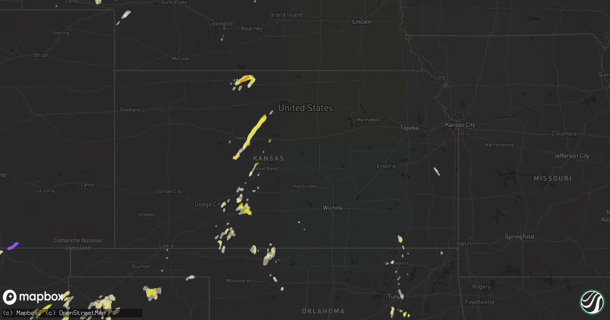
Hail Map in Kansas on May 23, 2018
Get this storm
May 23 map
$229
one time, instant access
Download today. No call, no setup
Keep the $229
Bought the map and want the full workflow? Apply the entire $229 to a subscription within 7 days. None of it is wasted.
Every map, not just this one
This buys you this map. Subscription and you get every map we run, in the markets you choose from a few cities to whole states to nationwide. Plus real-time alerts the moment a storm fires.
Contact data
Name, contact info, occupancy, even credit band for addresses in the footprint. You go from where it hit to who to call.
Become the source they trust
Unlimited branding weather history reports on demand. You already have the documented answer ready for the property owner, and you are the one who showed up with it.
Property data and RoofTrace estimates
Pull up any address you have got, its value and the exact code rules for that jurisdiction, straight from One Click Code. Then RoofTrace estimates the squares, pitch, and roof value, priced the way you price.
Storm reports in Kansas
Kansas
| Date | Description |
|---|---|
| 05/23/20185:40 PM CDT | Mostly peas to nickels... But a few quarter size. |
| 05/23/20185:38 PM CDT | A few stones up to half dollar size and estimated winds to at least 50 mph. |
| 05/23/20185:24 PM CDT | Measured wind gust from home weather station. |
| 05/23/20184:59 PM CDT | A local report indicates 1.00 inch wind near 9 NNW KENSINGTON |
| 05/23/20184:49 PM CDT | Quarter size hail reported in stuttgart. |
| 05/23/20184:42 PM CDT | Hail up to quarter size... Most smaller. |
| 05/23/20184:30 PM CDT | Hail started about 10 minutes ago...still ongoing. |
| 05/23/20184:10 PM CDT | Phillips county relaying a report of quarter size hail at intersection of hwy 183 and limestone road. |
| 05/23/20181:39 AM CDT | At 639 PM CDT, a severe thunderstorm was located 7 miles south of Osborne, or 30 miles west of Beloit, moving northeast at 30 mph. HAZARD...60 mph wind gusts and quarter size hail. SOURCE...Radar indicated. IMPACT...Hail damage to vehicles is expected. Expect wind damage to roofs, siding, and trees. Locations impacted include... Osborne and Downs. |
| 05/23/201812:59 AM CDT | At 559 PM CDT, a severe thunderstorm was located 8 miles southeast of Natoma, or 13 miles northeast of Emmeram, moving northeast at 30 mph. HAZARD...Golf ball size hail and 70 mph wind gusts. SOURCE...Radar indicated. IMPACT...People and animals outdoors will be injured. Expect hail damage to roofs, siding, windows, and vehicles. Expect considerable tree damage. Wind damage is also likely to mobile homes, roofs, and outbuildings. this severe thunderstorm will remain over mainly rural areas of southern Osborne County. |
| 05/23/201812:45 AM CDT | At 544 PM CDT, a severe thunderstorm was located near Wellsford, moving northeast at 15 mph. HAZARD...60 mph wind gusts and penny size hail. SOURCE...Radar indicated. IMPACT...Expect damage to roofs, siding, and trees. Locations impacted include... Pratt, Haviland, Iuka, Cullison, Byers and Wellsford. |
| 05/23/201812:38 AM CDT | At 538 PM CDT, a severe thunderstorm was located over Phillipsburg, moving north at 20 mph. HAZARD...60 mph wind gusts and quarter size hail. SOURCE...Radar indicated. IMPACT...Hail damage to vehicles is expected. Expect wind damage to roofs, siding, and trees. this severe thunderstorm will remain over mainly rural areas of northeastern Phillips County. |
| 05/23/201812:29 AM CDT | At 529 PM CDT, a severe thunderstorm was located near Kensington, or 13 miles east of Phillipsburg, moving northeast at 10 mph. HAZARD...60 mph wind gusts and quarter size hail. SOURCE...Radar indicated. IMPACT...Hail damage to vehicles is expected. Expect wind damage to roofs, siding, and trees. this severe thunderstorm will remain over mainly rural areas of northwestern Smith and east central Phillips Counties. |
| 05/23/201812:07 AM CDT | At 507 PM CDT, a severe thunderstorm was located near Victoria, moving northeast at 25 mph. HAZARD...60 mph wind gusts and quarter size hail. SOURCE...Radar indicated. IMPACT...Hail damage to vehicles is expected. Expect wind damage to roofs, siding, and trees. Locations impacted include... Victoria, Walker, Emmeram, Toulon and Munjor. |
| 05/22/201811:49 PM CDT | At 448 PM CDT, a severe thunderstorm was located just northwest of Phillipsburg, and for another storm just north of Kirwin. These storms were moving northeast at 25 mph. HAZARD...Ping pong ball size hail and 60 mph wind gusts. SOURCE...Radar indicated. IMPACT...People and animals outdoors will be injured. Expect hail damage to roofs, siding, windows, and vehicles. Expect wind damage to roofs, siding, and trees. Locations impacted include... Phillipsburg, Agra and Kirwin. |
| 05/22/201811:14 PM CDT | At 414 PM CDT, a severe thunderstorm was located 7 miles north of Phillipsburg, moving northeast at 15 mph. This warning extends the previous warning that was in effect. HAZARD...Golf ball size hail and 60 mph wind gusts. SOURCE...Radar indicated. IMPACT...People and animals outdoors will be injured. Expect hail damage to roofs, siding, windows, and vehicles. Expect wind damage to roofs, siding, and trees. this severe thunderstorm will remain over mainly rural areas of northeastern Phillips County. |
| 05/22/201810:55 PM CDT | At 355 PM CDT, a severe thunderstorm was located just north of Phillipsburg, moving northeast at 20 mph. HAZARD...Golf ball size hail and 60 mph wind gusts. SOURCE...Radar indicated. IMPACT...People and animals outdoors will be injured. Expect hail damage to roofs, siding, windows, and vehicles. Expect wind damage to roofs, siding, and trees. this severe thunderstorm will remain over mainly rural areas of northeastern Phillips County. |
| 05/22/201810:45 PM CDT | At 345 PM CDT, a severe thunderstorm was located near Phillipsburg, moving northeast at 20 mph. HAZARD...Golf ball size hail and 60 mph wind gusts. SOURCE...Radar indicated. IMPACT...People and animals outdoors will be injured. Expect hail damage to roofs, siding, windows, and vehicles. Expect wind damage to roofs, siding, and trees. this severe thunderstorm will remain over mainly rural areas of central Phillips County. |
| 05/22/20188:45 PM CDT | A local report indicates 60 MPH wind near 2 N NASHVILLE |
All States Impacted by Hail Map on May 23, 2018
Cities Impacted by Hail Map on May 23, 2018
- Leesville, LA
- Buffalo, OK
- Ashland, KS
- Vicksburg, MS
- Dalhart, TX
- Stratford, TX
- Dumas, TX
- Smithwick, SD
- Oral, SD
- Spencer, NE
- Oneill, NE
- Las Vegas, NM
- Anton Chico, NM
- Ribera, NM
- Garita, NM
- Elida, NM
- Portales, NM
- Clovis, NM
- Texico, NM
- Minneola, KS
- Watson, OK
- Merrifield, MN
- Crosby, MN
- Volborg, MT
- Vilonia, AR
- Conway, AR
- Onamia, MN
- Mullen, NE
- Tryon, NE
- Arthur, NE
- Lewellen, NE
- Lemoyne, NE
- Oshkosh, NE
- Sutherland, NE
- Chappell, NE
- Protection, KS
- Sallisaw, OK
- Cameron, LA
- Okmulgee, OK
- Beggs, OK
- Phillipsburg, KS
- Lenapah, OK
- Fairview, OK
- Louin, MS
- Bay Springs, MS
- Lame Deer, MT
- Forsyth, MT
- Birney, MT
- Ashland, MT
- Otter, MT
- Knotts Island, NC
- Mora, NM
- Bastrop, LA
- Custer, MT
- Branson, MO
- Fort Stockton, TX
- Balmorhea, TX
- Whitney, NE
- Crawford, NE
- Edgemont, SD
- Oelrichs, SD
- Lewis, KS
- Spearman, TX
- Valliant, OK
- Frederick, SD
- Pine Ridge, SD
- Porcupine, SD
- Manderson, SD
- Wounded Knee, SD
- Bowman, ND
- Haviland, KS
- Mullinville, KS
- Greensburg, KS
- Tinnie, NM
- Mescalero, NM
- Jordan, MT
- Edenton, NC
- Marathon, TX
- Glendive, MT
- Haynesville, LA
- Buena Vista, NM
- Rainsville, NM
- Ocate, NM
- Carrollton, MS
- Channing, TX
- Kiefer, OK
- Lodge Grass, MT
- Clinton, ME
- Eagletown, OK
- Forest, MS
- Alva, OK
- Newell, SD
- Nisland, SD
- Belle Fourche, SD
- Lovington, NM
- Lake Charles, LA
- Fallon, MT
- Harper, KS
- Ramona, OK
- Collinsville, OK
- Medina, ND
- Marsland, NE
- Jonesville, LA
- Chadron, NE
- Kyle, SD
- Mounds, OK
- Glenpool, OK
- Terry, MT
- Kinsey, MT
- Nara Visa, NM
- Mosquero, NM
- Logan, NM
- Belpre, KS
- Circle, MT
- Aitkin, MN
- Chesapeake, VA
- Virginia Beach, VA
- Lindsay, MT
- Fort Davis, TX
- Savage, MT
- Lambert, MT
- Sidney, MT
- Fairview, MT
- Waynoka, OK
- Aline, OK
- Cleo Springs, OK
- Roy, NM
- La Crosse, KS
- Russell, KS
- Gorham, KS
- Victoria, KS
- Paradise, KS
- Hays, KS
- Waldo, KS
- Bison, KS
- De Queen, AR
- Nashville, AR
- Lockesburg, AR
- El Paso, AR
- Harrison, NE
- Venango, NE
- Grant, NE
- Buffalo, SD
- Denham Springs, LA
- Greensburg, LA
- Clinton, LA
- Hammond, MT
- Saint Martinville, LA
- Bartlesville, OK
- Parkston, SD
- Dimock, SD
- Lexington, NE
- Pittsboro, NC
- Brandon, MS
- Lena, MS
- De Berry, TX
- Torrington, WY
- Hartley, TX
- Idabel, OK
- Kilgore, TX
- Loreauville, LA
- Niobrara, NE
- Billings, MT
- Elizabeth City, NC
- Alpine, TX
- Strathcona, MN
- Iliff, CO
- Sterling, CO
- Texarkana, AR
- Creighton, NE
- Broken Bow, OK
- Beach, ND
- Paxton, NE
- Rosston, OK
- Star City, AR
- Mansfield, LA
- Coushatta, LA
- Kadoka, SD
- Snow, OK
- Loving, NM
- Carlsbad, NM
- Angela, MT
- Tyner, NC
- Hertford, NC
- San Jon, NM
- Cleveland, ND
- Homer, LA
- Kirwin, KS
- Agra, KS
- Kensington, KS
- Henning, MN
- Plainview, NE
- Brunswick, NE
- Neligh, NE
- Haskell, OK
- Bixby, OK
- Fort Laramie, WY
- Moses Lake, WA
- Sidney, NE
- Turpin, OK
- Epes, AL
- Gainesville, AL
- Emelle, AL
- Whitman, NE
- Grady, AR
- Dumas, AR
- Gould, AR
- Wheatland, WY
- Guernsey, WY
- Nashoba, OK
- Raleigh, MS
- Kinsley, KS
- Loup City, NE
- Fairmount, ND
- Campbell, MN
- Wahpeton, ND
- Worden, MT
- Forbes, ND
- Freedom, ME
- Unity, ME
- Dodson, LA
- Everton, MO
- Barnard, SD
- Van Horn, TX
- Searsmont, ME
- Morrill, ME
- Utica, MS
- Center, NE
- Jay Em, WY
- Quitman, MS
- Lingle, WY
- Yoder, WY
- Colstrip, MT
- Burwell, NE
- Rayville, LA
- Jerico Springs, MO
- McCracken, KS
- Greenwood, MS
- Roswell, NM
- Aberdeen, SD
- Shreveport, LA
- Raton, NM
- Booker, TX
- Balko, OK
- Newellton, LA
- Alzada, MT
- Lance Creek, WY
- Dewey, OK
- Wann, OK
- Atkinson, NE
- Fairfax, SD
- Spivey, KS
- Amistad, NM
- Sedan, NM
- Allen, SD
- Wanblee, SD
- Pelahatchie, MS
- Morton, MS
- Canton, MS
- Carthage, MS
- Bristow, NE
- Lynch, NE
- Scroggins, TX
- Waldron, AR
- Tucumcari, NM
- Ashby, NE
- Wannaska, MN
- Firth, ID
- Salt Flat, TX
- Tripp, SD
- Ethan, SD
- Aimwell, LA
- Osborne, KS
- Garfield, KS
- Ozan, AR
- Columbus, AR
- Hope, AR
- Washington, AR
- Grygla, MN
- Alexander, ND
- McCall Creek, MS
- Pawnee Rock, KS
- Busby, MT
- Arkadelphia, AR
- Offerle, KS
- New Ulm, TX
- Ellis, KS
- Culbertson, MT
- Arco, MN
- Milaca, MN
- Litchfield, NE
- Spearville, KS
- Ford, KS
- Hardtner, KS
- Trinchera, CO
- Bayard, NE
- White Castle, LA
- Gruver, TX
- Skiatook, OK
- Clayton, NM
- Texline, TX
- Artesia, NM
- Larned, KS
- Quitman, LA
- Choudrant, LA
- Eros, LA
- Chatham, LA
- Muleshoe, TX
- Tulsa, OK
- Craigmont, ID
- Ruston, LA
- Sapulpa, OK
- Sparkman, AR
- Gurdon, AR
- Fouke, AR
- West, MS
- Ida, LA
- Vivian, LA
- Greeley, KS
- Garnett, KS
- Wadena, MN
- Adrian, TX
- Conchas Dam, NM
- Mineral Springs, AR
- Olivet, SD
- Moyock, NC
- Ballantine, MT
- Winnsboro, TX
- Sand Springs, MT
- Brainerd, MN
- Cruger, MS
- Lexington, MS
- Beresford, SD
- Centerville, SD
- Henryetta, OK
- Independence, KS
- Huntley, MT
- Keystone, NE
- Rosebud, MT
- Hugo, CO
- Logan, KS
- Okolona, AR
- Isabella, OK
- Stamps, AR
- Lewisville, AR
- Arcadia, NE
- Bucklin, KS
- Akron, CO
- Caney, KS
- Marshall, TX
- Bunch, OK
- Vian, OK
- Leola, SD
- Citronelle, AL
- Havana, KS
- Vining, MN
- Deer Creek, MN
- Walnut Grove, MO
- Jonesboro, LA
- Holcomb, MS
- Liebenthal, KS
- Capitol, MT
- Columbia, SD
- Epps, LA
- Cleveland, NM
- Woodrow, CO
- Emerson, AR
- Hobbs, NM
- Monument, NM
- Owasso, OK
- Minneota, MN
- Perryton, TX
- Bristol, SD
- Wolf Point, MT
- Sanders, MT
- Hysham, MT
- Tatum, NM
- Greenfield, MO
- Courtland, MS
- Pope, MS
- Milnesand, NM
- Hoisington, KS
- Winnsboro, LA
- Delhi, LA
- Cherokee, OK
- Smithfield, NE
- Miami, OK
- Port Gibson, MS
- Martin, SD
- Scotland, SD
- Kaylor, SD
- Pulaski, MS
- Hardesty, OK
- Overton, TX
- Boyce, LA
- Alexandria, LA
- Talala, OK
- Coldwater, KS
- Ismay, MT
- Peetz, CO
- Chapel Hill, NC
- Raymond, MS
- Jackson, MS
- Alamo, ND
- Greenwood, LA
- Waskom, TX
- Kersey, CO
- Alexander, KS
- Bennett, CO
- Hudson, CO
- Clarksdale, MS
- Winnfield, LA
- Belvidere, NC
- Ochelata, OK
- Ashdown, AR
- Elk City, KS
- Prescott, AR
- Albert, KS
- Great Bend, KS
- Gillham, AR
- Texarkana, TX
- Hooks, TX
- Prairie View, KS
- Dubach, LA
- Lockwood, MO
- McLaughlin, SD
- Bainville, MT
- Shongaloo, LA
- Bertrand, NE
- Kiowa, KS
- Durant, MS
- Westport, SD
- Boligee, AL
- Big Springs, NE
- Brule, NE
- Sheridan, WY
- Miles City, MT
- Cottondale, AL
- Leesburg, TX
- Fairfield, ND
- Belfield, ND
- Wishek, ND
- Minden, LA
- Ironton, MN
- Centerville, KS
- Parker, KS
- Deerwood, MN
- Kit Carson, CO
- Glade, KS
- Bunker Hill, KS
- Trinidad, CO
- Terlingua, TX
- Big Bend National Park, TX
- Pompeys Pillar, MT
- Reeds Spring, MO


