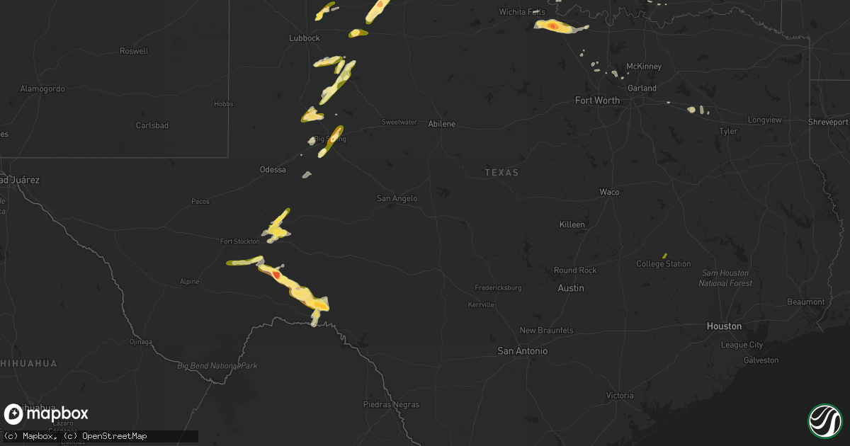
Hail Map in Texas on May 23, 2016
Get this storm
May 23 map
$229
one time, instant access
Download today. No call, no setup
Keep the $229
Bought the map and want the full workflow? Apply the entire $229 to a subscription within 7 days. None of it is wasted.
Every map, not just this one
This buys you this map. Subscription and you get every map we run, in the markets you choose from a few cities to whole states to nationwide. Plus real-time alerts the moment a storm fires.
Contact data
Name, contact info, occupancy, even credit band for addresses in the footprint. You go from where it hit to who to call.
Become the source they trust
Unlimited branding weather history reports on demand. You already have the documented answer ready for the property owner, and you are the one who showed up with it.
Property data and RoofTrace estimates
Pull up any address you have got, its value and the exact code rules for that jurisdiction, straight from One Click Code. Then RoofTrace estimates the squares, pitch, and roof value, priced the way you price.
Storm reports in Texas
Texas
| Date | Description |
|---|---|
| 05/23/20166:29 PM CDT | Accumulations of .75-1 inch hailstones |
| 05/23/20166:28 PM CDT | A local report indicates 1.75 inch wind near SILVERTON |
| 05/23/20166:26 PM CDT | Quarter size hail lasted from 624 pm to 626 pm. |
| 05/23/20166:03 PM CDT | A local report indicates 1.75 inch wind near 2 S BIG SPRING |
| 05/23/20165:11 PM CDT | A local report indicates 1.75 inch wind near PETERSBURG |
| 05/23/20165:05 PM CDT | A few baseball size hail reports |
| 05/23/20164:15 PM CDT | A local report indicates 1.75 inch wind near 2 SE LELIA LAKE |
| 05/23/20164:03 PM CDT | Received via spotter network. |
| 05/23/20164:02 PM CDT | Received via spotter network. |
| 05/23/20163:59 PM CDT | A local report indicates 1.00 inch wind near 4 E CLARENDON |
| 05/23/20169:35 AM CDT | Trees down on 656 between northfield and turkey |
| 05/23/20167:30 AM CDT | Relayed by kfdx tv |
| 05/23/201612:10 AM CDT | Dime to quarter size hail along highway 70. |
| 05/22/201611:44 PM CDT | A local report indicates 1.50 inch wind near N HOWARDWICK |
| 05/22/201611:42 PM CDT | A local report indicates 1.00 inch wind near 3 N HOWARDWICK |
| 05/22/201611:41 PM CDT | A local report indicates 1.75 inch wind near 1 NE HOWARDWICK |
| 05/22/201611:31 PM CDT | Quarter size hail up to half dollar size hail in howardwick |
| 05/22/201610:08 PM CDT | Telephone pole down |
| 05/22/201610:06 PM CDT | Dime to half dollar size hail reported along 287 northwest of clarendon. |
| 05/22/201610:00 PM CDT | Power flashes observed |
| 05/22/20169:43 PM CDT | Spotter report |
| 05/22/20169:38 PM CDT | A local report indicates 1.00 inch wind near 1 W BOOKER |
| 05/22/20169:30 PM CDT | Large tornado occurred from about 934 pm to 1008 pm and moved north-northwest. Tds observed to 20k feet. |
| 05/22/20169:23 PM CDT | A local report indicates 2.00 inch wind near 4 SE MATADOR |
| 05/22/20169:21 PM CDT | A local report indicates 1.75 inch wind near 7 SE TURKEY |
| 05/22/20168:32 PM CDT | Late report...thunderstorm gust front blew thru with estimated 60 mph winds...rain was blowing sideways. |
| 05/22/20168:20 PM CDT | A local report indicates 1.00 inch wind near 1 S POST |
| 05/22/20168:15 PM CDT | A local report indicates 2.00 inch wind near DARROUZETT |
| 05/22/20168:10 PM CDT | A local report indicates 2.50 inch wind near DARROUZETT |
| 05/22/20168:05 PM CDT | Hail began around 805pm and lasted through 830pm. Hail ranged in size...with largest being golf ball sized. |
| 05/22/20168:05 PM CDT | Late report of ping pong ball sized hail with a thunderstorm that passed over at 0805 pm cdt. |
| 05/22/20168:03 PM CDT | A local report indicates 1.75 inch wind near 1 S ALANREED |
| 05/22/20168:02 PM CDT | Hail on ground at i-40 rest stop at mile marker 129 |
| 05/22/20168:00 PM CDT | A local report indicates 1.00 inch wind near 5 NNE TURKEY |
| 05/22/20167:55 PM CDT | A local report indicates 3.11 inch wind near 1 SE ALANREED |
| 05/22/20167:52 PM CDT | A local report indicates 1.00 inch wind near TURKEY |
| 05/22/20167:52 PM CDT | Received via spotter network. |
| 05/22/20167:48 PM CDT | A local report indicates 2.00 inch wind near 3 E ALANREED |
| 05/22/20167:44 PM CDT | Quarter size hail and estimated wind gust of 60 mph. |
| 05/22/20167:43 PM CDT | A local report indicates 1.50 inch wind near 6 E WOLF CREEK PARK |
| 05/22/20167:42 PM CDT | A local report indicates 1.75 inch wind near 1 W ALANREED |
| 05/22/20167:36 PM CDT | A local report indicates 1.25 inch wind near 10 N GAIL |
| 05/22/20167:34 PM CDT | Penny and nickel hail with a few golf balls mixed in. |
| 05/22/20167:13 PM CDT | Received via twitter. |
| 05/22/20167:12 PM CDT | Mostly nickel size hail with a few quarters mixed in. |
| 05/22/20167:10 PM CDT | Received via twitter. |
All States Impacted by Hail Map on May 23, 2016
Cities Impacted by Hail Map on May 23, 2016
- Hinton, IA
- Sioux City, IA
- Akron, IA
- Elk Point, SD
- Merrill, IA
- North Sioux City, SD
- Jefferson, SD
- Westfield, IA
- Le Mars, IA
- Staplehurst, NE
- Bee, NE
- Seward, NE
- Loveland, OK
- Renville, MN
- Lake Lillian, MN
- Blomkest, MN
- Danube, MN
- Smith Center, KS
- Idalou, TX
- Petersburg, TX
- Sergeant Bluff, IA
- Sutton, NE
- Easton, MD
- Cordova, MD
- Church Hill, MD
- Centreville, MD
- Hunter, KS
- Ogallah, KS
- Catharine, KS
- Simpson, KS
- Glade, KS
- Winona, KS
- Plainville, KS
- Collyer, KS
- Kirwin, KS
- Victoria, KS
- Glasco, KS
- Penokee, KS
- Russell, KS
- Wakeeney, KS
- Logan, KS
- Cedar, KS
- Morland, KS
- Oakley, KS
- Quinter, KS
- Downs, KS
- Selden, KS
- Gorham, KS
- Monument, KS
- Sylvan Grove, KS
- Paradise, KS
- Waldo, KS
- Gaylord, KS
- Colby, KS
- Minneapolis, KS
- Hays, KS
- Luray, KS
- Oberlin, KS
- Woodston, KS
- Alton, KS
- Stockton, KS
- Phillipsburg, KS
- Barnard, KS
- Bogue, KS
- Glen Elder, KS
- Jennings, KS
- Norton, KS
- Osborne, KS
- Beloit, KS
- Park, KS
- Norcatur, KS
- Damar, KS
- Hill City, KS
- Natoma, KS
- Palco, KS
- Rexford, KS
- Prairie View, KS
- Ellis, KS
- Dresden, KS
- Hoxie, KS
- Tipton, KS
- Grinnell, KS
- Lucas, KS
- Grainfield, KS
- Portis, KS
- Delphos, KS
- Laverne, OK
- Follett, TX
- Darrouzett, TX
- Buffalo, OK
- Groom, TX
- Madill, OK
- Ardmore, OK
- Rapidan, VA
- Mitchells, VA
- Culpeper, VA
- Miami, TX
- Van, TX
- Grand Saline, TX
- Lindale, TX
- Mankato, KS
- Darwin, MN
- Cokato, MN
- Hutchinson, MN
- Howard Lake, MN
- Silver Lake, MN
- Dassel, MN
- McCamey, TX
- Claude, TX
- Clarendon, TX
- Mclean, TX
- Waverly, MN
- Buffalo, MN
- Balko, OK
- Booker, TX
- Aurora, NE
- Harvard, NE
- Doniphan, NE
- Giltner, NE
- Trumbull, NE
- Agra, KS
- Kensington, KS
- Perryton, TX
- Tipton, OK
- Grandfield, OK
- Devol, OK
- Frederick, OK
- Altus, OK
- Hollister, OK
- Headrick, OK
- Big Spring, TX
- Miltonvale, KS
- Clay Center, KS
- Hastings, NE
- Inland, NE
- Kingsley, IA
- Remsen, IA
- Marcus, IA
- Platte Center, NE
- Woodrow, CO
- Dannebrog, NE
- Akron, CO
- Knott, TX
- Gail, TX
- Ackerly, TX
- Lenorah, TX
- Bloomington, NE
- Riverton, NE
- Ashland, KS
- Burr Oak, KS
- Inavale, NE
- Webber, KS
- Superior, NE
- Belleville, KS
- Red Cloud, NE
- Republic, KS
- Esbon, KS
- Courtland, KS
- Lebanon, KS
- Formoso, KS
- Scandia, KS
- Campbell, NE
- Guide Rock, NE
- Bladen, NE
- Franklin, NE
- Lockney, TX
- Ponder, TX
- Decatur, TX
- Sheldon, IA
- Boyden, IA
- Krum, TX
- Locust Dale, VA
- Orange, VA
- Bellevue, TX
- Henrietta, TX
- Floydada, TX
- Ashton, IA
- George, IA
- Matlock, IA
- Sibley, IA
- Post, TX
- Fort Stockton, TX
- Dryden, TX
- Stewart, MN
- Matador, TX
- Roaring Springs, TX
- Litchfield, MN
- Fort Riley, KS
- Manhattan, KS
- Junction City, KS
- Ogden, KS
- Colon, NE
- Ellsworth, KS
- Kanopolis, KS
- Flower Mound, TX
- Argyle, TX
- Lake Dallas, TX
- Denton, TX
- Lewisville, TX
- Ringgold, TX
- Bowie, TX
- Montague, TX
- Nocona, TX
- Saint Jo, TX
- Morton, MN
- Chapman, NE
- Central City, NE
- Denton, MD
- Olsburg, KS
- Nebraska City, NE
- Fort Supply, OK
- Woodward, OK
- Mooreland, OK
- Funk, NE
- Axtell, NE
- Hampton, NE
- Hordville, NE
- Marquette, NE
- Granville, IA
- Davey, NE
- Valparaiso, NE
- Lincoln, NE
- Raymond, NE
- Ceresco, NE
- Lelia Lake, TX
- Hedley, TX
- Palmer, NE
- Saint Paul, NE
- Phillips, NE
- Yuma, CO
- Delia, KS
- Quitaque, TX
- Bunker Hill, KS
- Muenster, TX
- Fluvanna, TX
- Iraan, TX
- Ozona, TX
- Crane, TX
- Moville, IA
- Nashoba, OK
- Alvord, TX
- Comstock, TX
- Waverly, NE
- Afton, TX
- Dickens, TX
- Mcadoo, TX
- Lakeview, TX
- Burrton, KS
- Annandale, MN
- Homestead, FL
- Garland, NE
- Ulysses, NE
- Wood River, NE
- Bradshaw, NE
- Stromsburg, NE
- Polk, NE
- York, NE
- Alda, NE
- Grand Island, NE
- Benedict, NE
- Waco, NE
- Gresham, NE
- Ryan, OK
- Grand Rapids, MN
- Brush, CO
- Wilburton, OK
- Terrell, TX
- Malcolm, NE
- Wakefield, KS
- Turkey, TX
- Silverton, TX
- Childress, TX
- Red Rock, OK
- Mount Hope, KS
- Windsor, PA
- Red Lion, PA
- York, PA
- Ashland, NE
- Murdock, NE
- Tahoka, TX
- Wilson, TX
- Mannsville, OK
- Justiceburg, TX
- Owings, MD
- Sunderland, MD
- Huntingtown, MD
- Crosbyton, TX
- Craig, NE
- Oakland, NE
- Pampa, TX
- Shelton, NE
- Sedgwick, KS
- Haven, KS
- Mayetta, KS
- Breckenridge, MO
- Alton, IA
- Hospers, IA
- Milford, NE
- Beaver Crossing, NE
- Weston, NE
- Nehawka, NE
- Weeping Water, NE
- Avoca, NE
- Meriden, KS
- Topeka, KS
- Buffalo Lake, MN
- Tekamah, NE
- Wisner, NE
- Elmer, OK
- Wichita Falls, TX
- Temple, OK
- Duke, OK
- Hastings, OK
- Davidson, OK
- Gould, OK
- Byers, TX
- Waurika, OK
- Olustee, OK
- Randlett, OK
- Walters, OK
- Saint Libory, NE
- Redwood Falls, MN
- Cairo, NE
- Stanton, TX
- Onaga, KS
- Emmett, KS
- Fullerton, NE
- Mead, OK
- Durant, OK
- Shattuck, OK
- Little Rock, IA
- Rushmore, MN
- Colwich, KS
- Canadian, TX
- Memphis, TX
- Hoyt, KS
- Fargo, OK
- Winsted, MN
- Fort Belvoir, VA
- Glencoe, OK
- Clarks, NE
- Saint Michaels, MD
- Riley, KS
- Saint George, KS
- Dallastown, PA
- Wrightsville, PA
- Frisco, TX
- The Colony, TX
- Bird Island, MN
- Benkelman, NE
- Comanche, OK
- Duncan, OK
- Plattsmouth, NE
- Murray, NE
- Wills Point, TX
- Canton, TX
- Edgewood, TX
- Valley Center, KS
- Midland, TX
- Garnett, KS
- Frazee, MN
- Detroit Lakes, MN
- Chesapeake Beach, MD
- Anton, CO
- Radiant, VA
- Cope, CO
- Eckley, CO
- Billings, OK
- Coahoma, TX
- Harlan, IA
- Columbia, PA
- Marietta, PA
- Mount Joy, PA
- North Bend, NE
- Ames, NE
- Willow, OK
- Fremont, NE
- Decatur, NE
- Glencoe, MN
- Kintyre, ND
- Clayton, OK
- Walthill, NE
- Westmoreland, KS
- Montrose, MN
- Fairmont, NE
- Exeter, NE
- Homer, NE
- Fruitvale, TX
- Bozman, MD
- Wittman, MD
- Kincaid, KS
- Paducah, TX
- Maize, KS
- Freedom, OK
- Jewell, KS
- Randall, KS
- Talihina, OK
- Leonardville, KS
- Perry, KS
- Cee Vee, TX
- Elkwood, VA
- Brandy Station, VA
- Cheney, KS
- Haddam, KS
- Dorrance, KS
- Shelby, NE
- Pilger, NE
- Howells, NE
- Orange City, IA
- Hutchinson, KS
- Brewster, MN
- Worthington, MN
- Hollis, OK
- Prince Frederick, MD
- May, OK
- Cuba, KS
- Mulvane, KS
- Otis, CO
- Garden City, TX
- Wray, CO
- Carrollton, TX
- Percival, IA
- Dunbar, NE
- Union, NE
- Glenvil, NE
- Rising City, NE
- Surprise, NE
- Archer, NE
- Utica, NE
- David City, NE
- Jamestown, KS
- Concordia, KS
- Tescott, KS
- Happy, TX
- Manley, NE
- Louisville, NE
- Justin, TX
- Cleveland, ND
- Elmwood, NE
- Paullina, IA
- Honobia, OK
- Beemer, NE
- Enid, OK
- Lone Wolf, OK
- South Sioux City, NE
- Vernon, CO
- Clarkson, NE
- Leigh, NE
- Brookville, KS
- Dodge, NE
- West Point, NE
- Olivia, MN
- Goehner, NE
- Pleasant Dale, NE
- Monticello, MN
- Hubbard, NE
- Garber, OK
- Ocheyedan, IA
- Melvin, IA
- Gibbon, NE
- Ridgely, MD
- Alvo, NE
- Greenwood, NE
- Lester Prairie, MN
- Wahoo, NE
- Minden, NE
- Andale, KS
- Maple Lake, MN
- Chattanooga, OK
- Milford, KS
- Friend, NE
- Bigelow, MN
- Cleghorn, IA
- Pierson, IA
- Lenora, KS
- Almena, KS
- Protection, KS
- Lamesa, TX
- Tarzan, TX
- Bryan, TX
- College Station, TX


