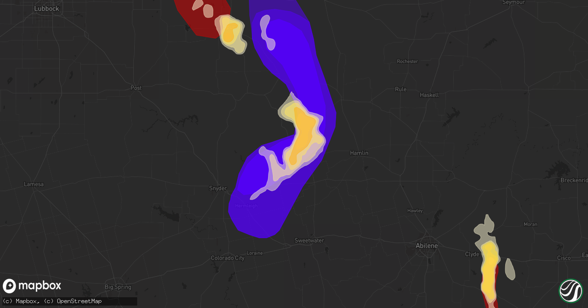
Hail Map in Rotan, TX on May 23, 2013
Get this storm
May 23 map
$229
one time, instant access
Download today. No call, no setup
Keep the $229
Bought the map and want the full workflow? Apply the entire $229 to a subscription within 7 days. None of it is wasted.
Every map, not just this one
This buys you this map. Subscription and you get every map we run, in the markets you choose from a few cities to whole states to nationwide. Plus real-time alerts the moment a storm fires.
Contact data
Name, contact info, occupancy, even credit band for addresses in the footprint. You go from where it hit to who to call.
Become the source they trust
Unlimited branding weather history reports on demand. You already have the documented answer ready for the property owner, and you are the one who showed up with it.
Property data and RoofTrace estimates
Pull up any address you have got, its value and the exact code rules for that jurisdiction, straight from One Click Code. Then RoofTrace estimates the squares, pitch, and roof value, priced the way you price.
Storm reports in Rotan, TX
Rotan, TX
| Date | Description |
|---|---|
| 05/23/20136:45 PM CDT | Damage to roof... Uprooted trees... And downed power lines east side of rotan |
| 05/23/20136:45 PM CDT | A local report indicates 60 MPH wind near 4 S ROTAN |
| 05/23/20136:30 PM CDT | Trees down on hwy 92. |
| 05/23/20136:30 PM CDT | Barn roof collapsed on hwy 70. |
| 05/23/20136:25 PM CDT | A local report indicates 60 MPH wind near 3 S ROTAN |
| 05/23/20136:24 PM CDT | A local report indicates 1.75 inch wind near ROTAN |
| 05/23/20136:23 PM CDT | A local report indicates a tornado near ROTAN |
| 05/23/20136:22 PM CDT | Barns blown away on fm 2832. Time estimated. |
| 05/23/20136:12 PM CDT | Roofs missing off of houses. |
| 05/23/20136:12 PM CDT | A local report indicates a tornado near ROTAN |
| 05/23/20136:12 PM CDT | A local report indicates 110 MPH wind near ROTAN |
| 05/23/20136:12 PM CDT | The tornado touched down at 612 pm cdt near east lee street on the east side of rotan. This tornado moved to the south southwest across highway 92 and across the rotan |
| 05/23/20136:10 PM CDT | A local report indicates 60 MPH wind near ROTAN |
| 05/23/20136:10 PM CDT | 100 block of mcarther st. Brick wall down from a house. |
| 05/23/20136:06 PM CDT | A local report indicates 80 MPH wind near ROTAN |
| 05/23/20136:03 PM CDT | A local report indicates 1.75 inch wind near ROTAN |
| 05/23/20136:02 PM CDT | Rotan fire department estimated a 60 mph wind gust in rotan. |
| 05/23/20135:52 PM CDT | Golf ball size just east of rotan |
All States Impacted by Hail Map on May 23, 2013
All Cities Impacted by Hail Map on May 23, 2013
- Rotan, TX
- Aspermont, TX
- Dickens, TX
- Mcadoo, TX
- Floydada, TX
- Crosbyton, TX
- Pauls Valley, OK
- Paoli, OK
- Little Genesee, NY
- Bolivar, NY
- Monterey, LA
- Sweetwater, TX
- Hermleigh, TX
- Snyder, TX
- Jayton, TX
- Artesia, NM
- Girard, TX
- Spur, TX
- Christmas, FL
- Baird, TX
- Stratford, OK
- Gail, TX
- Wynnewood, OK
- Ceres, NY
- Junction, TX
- Wayne, OK
- Old Glory, TX
- Elmore City, OK
- Maurertown, VA
- Toms Brook, VA
- Strasburg, VA
- Marathon, TX
- Jal, NM
- Mentone, TX
- Davis, OK
- Jonesville, LA
- Wellsville, NY
- Allentown, NY
- Friendship, NY
- Portville, NY
- Cross Plains, TX
- Conchas Dam, NM
- Madill, OK
- Sulphur, OK
- Trementina, NM
- Paw Paw, WV
- Clyde, TX
- Eldred, PA
- Shinglehouse, PA
- Blanchard, OK
- Albany, TX
- Lodge Grass, MT
- Las Vegas, NM
- Lockney, TX
- Afton, TX
- Knott, TX
- Lenorah, TX
- Stanton, TX
- Slanesville, WV
- Billings, MT
- Pryor, MT
- Pecos, TX
- Loraine, TX
- Colorado City, TX
- Big Spring, TX
- Woodstock, VA
- Rockledge, FL
- Melbourne, FL
- Saint Cloud, FL
- Hitchcock, OK
- Okeene, OK
- Watonga, OK
- El Reno, OK
- Mustang, OK
- Oklahoma City, OK
- Wheatland, OK
- Yukon, OK
- Washington, OK
- Newcastle, OK
- Lindsay, OK
- Purcell, OK
- Norman, OK
- Roff, OK
- Mill Creek, OK
- Byars, OK
- Hamlin, TX
- Roscoe, TX
- Paducah, TX
- Roby, TX
- Burkett, TX
- Coleman, TX
- Gouldbusk, TX
- Santa Anna, TX
- Roaring Springs, TX
- Matador, TX
- Lamesa, TX
- Odonnell, TX
- Vidalia, LA
- Amarillo, TX
- Dumas, TX
- Masterson, TX
- Carlsbad, NM
- Loving, NM
- Alpine, TX
- Fort Stockton, TX
- Hiddenite, NC
- Taylorsville, NC
- Moravian Falls, NC
- Inman, SC
- Boiling Springs, SC
- Campobello, SC


