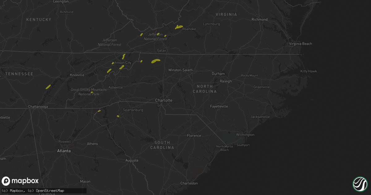
Hail Map in North Carolina on May 22, 2013
Get this storm
May 22 map
$229
one time, instant access
Download today. No call, no setup
Keep the $229
Bought the map and want the full workflow? Apply the entire $229 to a subscription within 7 days. None of it is wasted.
Every map, not just this one
This buys you this map. Subscription and you get every map we run, in the markets you choose from a few cities to whole states to nationwide. Plus real-time alerts the moment a storm fires.
Contact data
Name, contact info, occupancy, even credit band for addresses in the footprint. You go from where it hit to who to call.
Become the source they trust
Unlimited branding weather history reports on demand. You already have the documented answer ready for the property owner, and you are the one who showed up with it.
Property data and RoofTrace estimates
Pull up any address you have got, its value and the exact code rules for that jurisdiction, straight from One Click Code. Then RoofTrace estimates the squares, pitch, and roof value, priced the way you price.
Storm reports in North Carolina
North Carolina
| Date | Description |
|---|---|
| 05/22/20135:10 PM CDT | Trees down on north trade st. And landrum rd. |
| 05/22/20135:08 PM CDT | Sheriff office said trees down scattered throughout the county. Best downburst potential based on radar out ahead of storm collapse east of lake adger. |
| 05/22/20134:25 PM CDT | A relative of a nws employee experienced quarter sized hail while driving north on highway 9 through the sunny view community. The extremely heavy downpour created dang |
| 05/22/20132:47 PM CDT | Ranged from dime to quarter size |
| 05/22/20131:56 PM CDT | Observed at bryson dam |
| 05/22/20131:54 PM CDT | A local report indicates 1.00 inch wind near 3 NE BRYSON CITY |
| 05/22/20131:35 PM CDT | Tree across overlook dr. |
| 05/22/20131:35 PM CDT | Tree on house on spainhour st. |
| 05/22/201312:30 PM CDT | A local report indicates 1.00 inch wind near TROUT |
| 05/22/201311:30 AM CDT | Large limb down on power line on ledbetter rd. Spotter in avery creek area also estimated 60 mph gust. |
All States Impacted by Hail Map on May 22, 2013
Cities Impacted by Hail Map on May 22, 2013
- Wolcott, NY
- Cato, NY
- Red Creek, NY
- Martville, NY
- Tuttle, OK
- Yukon, OK
- Newcastle, OK
- Mustang, OK
- Oklahoma City, OK
- Wheatland, OK
- Blanchard, OK
- Plainfield, MA
- Windsor, MA
- Cummington, MA
- Camden, NY
- Taberg, NY
- Livingston Manor, NY
- Parksville, NY
- Roscoe, NY
- Lee Center, NY
- Williamsburg, MA
- Conway, MA
- Ashfield, MA
- Shelburne Falls, MA
- Hancock, MD
- Leverett, MA
- Shutesbury, MA
- Wendell, MA
- Williamstown, NY
- Pennellville, NY
- Central Square, NY
- Ava, NY
- Fulton, NY
- Constantia, NY
- Mallory, NY
- West Monroe, NY
- Bernhards Bay, NY
- Hastings, NY
- Deerfield, MA
- Athol, MA
- Sunderland, MA
- South Deerfield, MA
- Petersham, MA
- New Salem, MA
- Montague, MA
- Orange, MA
- Jericho, VT
- Hannibal, NY
- Ashville, PA
- Rome, NY
- Binghamton, NY
- Port Crane, NY
- Phoenix, NY
- Westernville, NY
- Boonville, NY
- Cleveland, NY
- Liberty, NY
- East Branch, NY
- Long Eddy, NY
- Claryville, NY
- Jeffersonville, NY
- Harpursville, NY
- Hitchcock, OK
- Berwick, LA
- Morgan City, LA
- Patterson, LA
- Charlemont, MA
- Verona, NY
- Blossvale, NY
- Sodus Point, NY
- North Rose, NY
- Hixson, TN
- Brewerton, NY
- West Leyden, NY
- Norman, OK
- Grahamsville, NY
- Loch Sheldrake, NY
- Hurleyville, NY
- Forestport, NY
- Remsen, NY
- Alder Creek, NY
- Clinton, NY
- Whitesboro, NY
- New York Mills, NY
- Utica, NY
- Yorkville, NY
- New Hartford, NY
- Marcy, NY
- Berkeley Springs, WV
- Traphill, NC
- Thurmond, NC
- Hays, NC
- Roaring Gap, NC
- McGrady, NC
- Millers Creek, NC
- Todd, NC
- Erwin, TN
- Unicoi, TN
- Hampton, TN
- Watauga, TN
- Blountville, TN
- Bristol, TN
- Piney Flats, TN
- Bluff City, TN
- Afton, TN
- Greeneville, TN
- Spring City, TN
- Evensville, TN
- Bryson City, NC
- Whittier, NC
- Cherokee, NC
- Limestone, TN
- Chuckey, TN
- Easley, SC
- Piedmont, SC
- Mountain Rest, SC
- Windsor, NY
- Ouaquaga, NY
- Pulaski, VA
- Dublin, VA
- Bland, VA
- Cedar Bluff, VA
- Tazewell, VA
- Pounding Mill, VA
- North Tazewell, VA
- Newport, VA
- Blacksburg, VA
- Salem, VA
- Catawba, VA
- Elliston, VA
- Bloomingdale, NY
- Lake Placid, NY
- Needmore, PA
- Mercersburg, PA
- Big Cove Tannery, PA
- McConnellsburg, PA
- Hustontown, PA
- Burnt Cabins, PA
- Orbisonia, PA
- Shade Gap, PA
- Fort Littleton, PA
- Clarion, PA
- Fairmount City, PA
- Strattanville, PA
- New Bethlehem, PA
- Cooksburg, PA
- Marienville, PA
- Corsica, PA
- Clarington, PA
- Sigel, PA
- Summerville, PA


