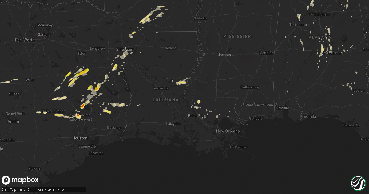
Hail Map in Louisiana on May 20, 2017
Get this storm
May 20 map
$229
one time, instant access
Download today. No call, no setup
Keep the $229
Bought the map and want the full workflow? Apply the entire $229 to a subscription within 7 days. None of it is wasted.
Every map, not just this one
This buys you this map. Subscription and you get every map we run, in the markets you choose from a few cities to whole states to nationwide. Plus real-time alerts the moment a storm fires.
Contact data
Name, contact info, occupancy, even credit band for addresses in the footprint. You go from where it hit to who to call.
Become the source they trust
Unlimited branding weather history reports on demand. You already have the documented answer ready for the property owner, and you are the one who showed up with it.
Property data and RoofTrace estimates
Pull up any address you have got, its value and the exact code rules for that jurisdiction, straight from One Click Code. Then RoofTrace estimates the squares, pitch, and roof value, priced the way you price.
Storm reports in Louisiana
Louisiana
| Date | Description |
|---|---|
| 05/20/20174:50 PM CDT | Tree reported fallen on a home on severn ave. Wind gusts likely around 45 mph based on nearby observations. |
| 05/20/20174:50 PM CDT | Tree reported fallen on a home on severn ave. Wind gusts likely around 45 mph based on nearby observations. |
| 05/20/201711:42 AM CDT | Power out at haughton middle school... Haughton high school... Kinsley court. |
| 05/20/201712:15 AM CDT | Quarter size report via ktbs facebook. |
| 05/19/201711:35 PM CDT | Power out in golden meadows subdivision and near parkway high school. |
| 05/19/201711:18 PM CDT | Trees and power lines down bayou drive between dixie garden and bermuda... Power out. |
| 05/19/201711:05 PM CDT | Multiple trees down on linwood road just north of stonewall frierson road. |
| 05/19/201711:03 PM CDT | Quarter size hail reported on norris ferry road south shreveport. |
| 05/19/201710:58 PM CDT | Several trees down near bridge east of stonewall... About 1 miles west of i-49 near mile marker 194. |
| 05/19/201710:45 PM CDT | Tree on power line linwood extension off stonewall frierson. |
| 05/19/201710:45 PM CDT | Tree down linwood extension stonewall on the road. |
All States Impacted by Hail Map on May 20, 2017
Cities Impacted by Hail Map on May 20, 2017
- Uvalde, TX
- Mount Holly, AR
- Stephens, AR
- Louann, AR
- Paynesville, WV
- Gretna, VA
- Crawfordsville, IN
- Thorntown, IN
- Colfax, IN
- Darlington, IN
- Grapeland, TX
- Palestine, TX
- Crockett, TX
- Rusk, TX
- Elkhart, TX
- Centerville, TX
- Alto, TX
- Oakwood, TX
- Freer, TX
- Laredo, TX
- Swainsboro, GA
- Charlestown, IN
- Memphis, IN
- Sellersburg, IN
- Kountze, TX
- Hampton, AR
- Lewisburg, KY
- Morgantown, KY
- Jonesville, LA
- Vidalia, LA
- Monterey, LA
- Iron City, TN
- Collinwood, TN
- Whitetop, VA
- Mouth Of Wilson, VA
- Caldwell, TX
- Blaine, KY
- Apple Springs, TX
- Billingsley, AL
- Prattville, AL
- Brandon, MS
- Mendenhall, MS
- Millbrook, AL
- Deatsville, AL
- Elmore, AL
- Floyds Knobs, IN
- New Liberty, KY
- Owenton, KY
- Woodville, TX
- Jasper, TX
- Kirbyville, TX
- Rainelle, WV
- Vernon Hill, VA
- Keeling, VA
- San Augustine, TX
- Pekin, IN
- Palmyra, IN
- Fairfield, NC
- Loretto, TN
- Blue Creek, OH
- Camden, AR
- Magnolia, AR
- Union Grove, AL
- Pearsall, TX
- Marshallville, GA
- Grant, AL
- Melvin, TX
- Eden, TX
- Clanton, AL
- Verbena, AL
- Concepcion, TX
- Falfurrias, TX
- Coldspring, TX
- Oakhurst, TX
- Pointblank, TX
- Huntsville, TX
- Rush, KY
- Grayson, KY
- Willis, TX
- Montgomery, TX
- Carrollton, KY
- Turners Station, KY
- Worthville, KY
- Sanders, KY
- Campbellsburg, KY
- Decatur, AL
- Trinity, AL
- Lost Creek, KY
- Rowdy, KY
- Clayhole, KY
- Big Stone Gap, VA
- Pennington Gap, VA
- Duffield, VA
- Dryden, VA
- Surgoinsville, TN
- Eidson, TN
- Cordova, AL
- Marysville, IN
- Lexington, IN
- Climax, NC
- Liberty, NC
- Franklinville, NC
- Ray City, GA
- Lakeland, GA
- Valdosta, GA
- Woodville, AL
- New Hope, AL
- Arab, AL
- Buena Vista, GA
- Rome, IN
- Cannelton, IN
- Wetumpka, AL
- Macon, MS
- Crossville, AL
- Onalaska, TX
- Groveton, TX
- New Waverly, TX
- Lufkin, TX
- Livingston, TX
- Nacogdoches, TX
- Kennard, TX
- Moscow, TX
- Corrigan, TX
- Chireno, TX
- Diboll, TX
- Comstock, TX
- Cromwell, KY
- Chapmanville, WV
- Dale, IN
- Gentryville, IN
- Encinal, TX
- Madisonville, TX
- Normangee, TX
- North Zulch, TX
- Herndon, KY
- Hopkinsville, KY
- Tuskegee, AL
- Zachary, LA
- Slaughter, LA
- Salem, IN
- Hearne, TX
- Franklin, TX
- Corydon, IN
- Magee, MS
- Cotulla, TX
- Emerson, AR
- Joaquin, TX
- Logansport, LA
- Center, TX
- Fort Valley, GA
- Columbiana, AL
- Newton, TX
- West Terre Haute, IN
- Terre Haute, IN
- Tell City, IN
- Lewisport, KY
- Hawesville, KY
- Ethel, LA
- Wilson, LA
- Somerville, AL
- Meadville, MS
- Conroe, TX
- Sylacauga, AL
- Cloverdale, VA
- Troutville, VA
- Roanoke, VA
- Vevay, IN
- Empire, AL
- McIntosh, AL
- Barksdale, TX
- Java, VA
- Walker, LA
- Denham Springs, LA
- Ashville, AL
- Tenaha, TX
- Saint Anthony, IN
- Ferdinand, IN
- Birdseye, IN
- Huntington, WV
- Bremen, AL
- White Pine, TN
- Shady Valley, TN
- Tylertown, MS
- Jayess, MS
- Lexington, AL
- Leoma, TN
- Sparta, GA
- Ohatchee, AL
- Alderson, WV
- Ozark, AL
- Jackson, AL
- Jolo, WV
- Jewell Ridge, VA
- Raysal, WV
- Winona, MS
- Vaiden, MS
- South Boston, VA
- Warren, TX
- Fred, TX
- Carthage, TX
- Columbus, MS
- Ripplemead, VA
- Magnolia, MS
- Mccomb, MS
- Valley Mills, TX
- Gatesville, TX
- Belhaven, NC
- Pantego, NC
- Quinwood, WV
- Charmco, WV
- Corinth, KY
- Stamping Ground, KY
- Buchanan, TN
- New Concord, KY
- Benton, LA
- Plain Dealing, LA
- Sarepta, LA
- Springhill, LA
- Shongaloo, LA
- Cotton Valley, LA
- Slocomb, AL
- Jacksonville, TX
- Goodlettsville, TN
- Greenbrier, TN
- Springfield, TN
- Jewett, TX
- Beeson, WV
- Spanishburg, WV
- Rock, WV
- Asherton, TX
- Fordyce, AR
- Thornton, AR
- Tilden, TX
- Joppa, AL
- Baileyton, AL
- Lagrange, GA
- Leavenworth, IN
- Milltown, IN
- Batesville, TX
- Crystal City, TX
- Olive Hill, KY
- Wolcott, IN
- English, IN
- Hurt, VA
- Chatham, VA
- Minter, AL
- Forest Home, AL
- Greenville, AL
- Waynesboro, MS
- Lawrenceville, IL
- Pembroke, KY
- Oak Grove, KY
- Fort Campbell, KY
- Whites Creek, TN
- Joelton, TN
- Rockdale, TX
- Newport, VA
- Pike Road, AL
- Shorter, AL
- Spring Hill, TN
- Ellaville, GA
- Welch, WV
- Elbert, WV
- Midville, GA
- Nashville, GA
- Shady Spring, WV
- Livingston, LA
- Weaver, AL
- Anniston, AL
- Jacksonville, AL
- Hillsville, VA
- Tallassee, AL
- Knippa, TX
- Sabinal, TX
- Underwood, IN
- Scottsburg, IN
- Royalton, KY
- Salyersville, KY
- Jackson, KY
- Oil Springs, KY
- Hagerhill, KY
- Maben, MS
- Mantee, MS
- Ivanhoe, VA
- Cripple Creek, VA
- Crestview, FL
- Staffordsville, KY
- Hazard, KY
- Georgetown, GA
- Meadow Bridge, WV
- Green Sulphur Springs, WV
- Grassy Meadows, WV
- Autaugaville, AL
- Lowndesboro, AL
- Ashland, KY
- Catlettsburg, KY
- Trinity, TX
- Chapmansboro, TN
- Ashland City, TN
- Owensboro, KY
- Utica, KY
- Shelby, AL
- Ponchatoula, LA
- Lena, MS
- Central City, KY
- Denton, KY
- Louisa, KY
- Crawford, MS
- Stambaugh, KY
- Hayneville, AL
- Tyler, AL
- Gadsden, AL
- Columbus, GA
- Robards, KY
- Herndon, WV
- Robert, LA
- Hammond, LA
- Blacksburg, VA
- Jumping Branch, WV
- Sulphur, IN
- Elizabeth, IN
- New Middletown, IN
- Tennyson, IN
- Flat Top, WV
- Blounts Creek, NC
- Chocowinity, NC
- Scranton, NC
- Linden, TN
- Parsons, TN
- Decaturville, TN
- Richwood, WV
- La Fayette, KY
- Brackettville, TX
- Boonville, IN
- Butler, KY
- Cumberland City, TN
- Tennessee Ridge, TN
- Stout, OH
- Fort Payne, AL
- Huntington, TX
- Otisco, IN
- Paris, TN
- Puryear, TN
- Harrell, AR
- Plantersville, TX
- Navasota, TX
- Hudsonville, MI
- Bethel, NC
- Robersonville, NC
- Calhoun, KY
- Jasper, AL
- Vanceburg, KY
- Baldwyn, MS
- Jemison, AL
- Crystal Springs, MS
- Chilhowie, VA
- Trenton, AL
- Hollytree, AL
- Russellville, OH
- Ripley, OH
- Keatchie, LA
- Stonewall, LA
- Frierson, LA
- Bossier City, LA
- Gloster, LA
- Shreveport, LA
- Keithville, LA
- Bennington, IN
- Versailles, IN
- New Albany, IN
- Canaan, IN
- Dillsboro, IN
- Nabb, IN
- Georgetown, IN
- Deputy, IN
- Greenville, IN
- Hanover, IN
- Madison, IN
- Borden, IN
- Bedford, KY
- Austin, IN
- Cross Plains, IN
- Milton, KY
- Brandenburg, KY
- Gloster, MS
- Depauw, IN
- La Fayette, GA
- Summerville, GA
- Shelbyville, TX
- Smithfield, KY
- Baton Rouge, LA
- Primm Springs, TN
- Lynch Station, VA
- Guston, KY
- Webster, KY
- Leesburg, GA
- Frankston, TX
- Dexter, GA
- Stockbridge, GA
- Washington, NC
- Purmela, TX
- Parrish, AL
- Princeton, WV
- Daleville, VA
- Blue Ridge, VA
- Buchanan, VA
- Letohatchee, AL
- Ferriday, LA
- Natchez, MS
- Church Hill, TN
- Rogersville, TN
- Shelbyville, TN
- McCall Creek, MS
- Smithdale, MS
- Bogue Chitto, MS
- Alma, GA
- Winchester, KY
- Mount Sterling, KY
- Sadieville, KY
- Soperton, GA
- Covington, LA
- Mandeville, LA
- Mauckport, IN
- Smithville, GA
- Bronwood, GA
- Grand Cane, LA
- Bon Aqua, TN
- Dickson, TN
- Bethlehem, IN
- New Washington, IN
- Evant, TX
- Leopold, IN
- Marengo, IN
- Hye, TX
- Johnson City, TX
- Fort Rucker, AL
- Daleville, AL
- Newton, AL
- Lawrenceburg, KY
- Jeffrey, WV
- Hewett, WV
- Marbury, AL
- Tuscaloosa, AL
- Northport, AL
- Smackover, AR
- Bearden, AR
- Walton, KY
- Crittenden, KY
- Hartselle, AL
- Falkville, AL
- Eatonton, GA
- Buckhead, GA
- Madison, GA
- Plantersville, AL
- Jones, AL
- Sabina, OH
- Washington Court House, OH
- Panther, WV
- Iaeger, WV
- Dublin, TX
- Hillister, TX
- Dalton, GA
- Lamar, IN
- Santa Claus, IN
- Saint Meinrad, IN
- Evanston, IN
- Florence, AL
- Leslie, GA
- College Station, TX
- Anderson, TX
- Big Wells, TX
- Menlo, GA
- Ideal, GA
- Oglethorpe, GA
- Seaman, OH
- Hinton, WV
- Randleman, NC
- Greensboro, GA
- Clarksville, TN
- Plymouth, NC
- Madisonville, KY
- Dublin, GA
- Fincastle, VA
- Bankston, AL
- Berry, AL
- Calhoun, GA
- Sugar Valley, GA
- Frankfort, KY
- Meridian, MS
- Jena, LA
- Trout, LA
- Winchester, OH
- Greensboro, NC
- Jamestown, NC
- D Hanis, TX
- Midway, TX
- Bristow, IN
- La Pryor, TX
- Jackson, LA
- Richland, GA
- Lumpkin, GA
- Cordele, GA
- Mansfield, LA
- New Richmond, IN
- Rocksprings, TX
- Centreville, MS
- New Brockton, AL
- Elba, AL
- Camp Creek, WV
- Kegley, WV
- Dilley, TX
- Eastaboga, AL
- Elm Grove, LA
- Caneyville, KY
- Georgetown, OH
- Hamersville, OH
- Bethel, OH
- Tarrytown, GA
- Booneville, KY
- Bon Wier, TX
- New Vienna, OH
- Wilmington, OH
- Summit, MS
- Tifton, GA
- Enigma, GA
- Dora, AL
- Sumiton, AL
- Hanceville, AL
- Auburn, AL
- Notasulga, AL
- Deridder, LA
- Summerfield, NC
- Selma, AL
- Fort Mitchell, AL
- Twilight, WV
- Ashburn, GA
- High Point, NC
- Brooksville, MS
- Delta, AL
- Maceo, KY
- Sweet Water, AL
- Mauk, GA
- Aberdeen, OH
- Manchester, OH
- Saint Francisville, LA
- Ventress, LA
- Clay, KY
- Providence, KY
- Ramseur, NC
- Pleasant Garden, NC
- Julian, NC
- Orlinda, TN
- Adairville, KY
- Franklin, KY
- Russellville, KY
- Kinder, LA
- Clarksburg, OH
- Haughton, LA
- Benton, IL
- Buffalo, TX
- West Union, OH
- California, KY
- Bridgeport, IL
- Sumner, IL
- Irvington, KY
- Bush, LA
- Garrison, KY
- Seagrove, NC
- Asheboro, NC
- Montgomery, AL
- Omaha, GA
- Hanson, KY
- Slaughters, KY
- Rumsey, KY
- Palmyra, TN
- Maplesville, AL
- Jamesville, NC
- Destin, FL
- Speedwell, VA
- Rural Retreat, VA
- Marion, AL
- Greensboro, AL
- Coosada, AL
- Piedmont, AL
- Brookhaven, MS
- Gladys, VA
- Long Island, VA
- Warrior, AL
- Gaylesville, AL
- Pine Apple, AL
- Verona, KY
- Warsaw, KY
- Akron, AL
- Manchester, KY
- Marquez, TX
- Tullahoma, TN
- Wartrace, TN
- Vardaman, MS
- Philpot, KY
- Sharon Grove, KY
- Trenton, KY
- Elkton, KY
- Horse Branch, KY
- Dunmor, KY
- Drakesboro, KY
- Rochester, KY
- Talladega, AL
- Augusta, KY
- Gordon, TX
- Princeton, AL
- Salem, VA
- Leakey, TX
- Pollok, TX
- Fries, VA
- Wytheville, VA
- Helena, AL
- Bessemer, AL
- Huntsville, AL
- Berry, KY
- Raymond, MS
- Terry, MS
- White House, TN
- White Bluff, TN
- Whitesville, KY
- Robbins, NC
- Glen, MS
- Dry Ridge, KY
- Indian Mound, TN
- Banks, AR
- Warren, AR
- Sardinia, OH
- Felicity, OH
- Foster, KY
- Moscow, OH
- Jamestown, OH
- Cedarville, OH
- De Leon, TX
- Brooksville, KY
- Eva, AL
- Graysville, TN
- Nicholls, GA
- Cleveland, TX
- Grandview, IN
- De Witt, AR
- Crocketts Bluff, AR
- Blackwater, VA
- Elko, GA
- Moundville, AL
- Branchville, IN
- Montezuma, GA
- Guntersville, AL
- Burns, TN
- Charlotte, TN
- Barboursville, WV
- Spearsville, LA
- Waiteville, WV
- Houlka, MS
- Centreville, AL
- West Blocton, AL
- Alexandria, AL
- La Grange, KY
- Calera, AL
- Morton, MS
- Live Oak, FL
- Westpoint, TN
- Enterprise, AL
- Jamestown, LA
- Independence, LA
- Holden, LA
- Albany, LA
- Celestine, IN
- De Berry, TX
- Canton, MS
- Soddy Daisy, TN
- McDaniels, KY
- Leitchfield, KY
- Falls Of Rough, KY
- Uniontown, AL
- Marion Junction, AL
- Sparta, KY
- Estillfork, AL
- Paint Rock, AL
- Gurley, AL
- Battletown, KY
- Cohutta, GA
- Utica, MS
- Allensville, KY
- Holly Pond, AL
- Liberty, MS
- Crosby, MS
- Lacombe, LA
- Brooksville, FL
- Braxton, MS
- Lowmansville, KY
- Reynolds, IN
- Boligee, AL
- Eutaw, AL
- Louisville, AL
- Clayton, AL
- Hohenwald, TN
- Eckerty, IN
- Lanesville, IN
- Bent Mountain, VA
- Butler, GA
- Meadowview, VA
- Glade Spring, VA
- Lexington, TN
- Naylor, GA
- Broaddus, TX
- Rhodelia, KY
- Payneville, KY
- Union Star, KY
- Pinola, MS
- Byromville, GA
- Concan, TX
- Realitos, TX
- Premont, TX
- Riviera, TX
- Swanquarter, NC
- Hurley, VA
- Danville, WV
- Ghent, WV
- Smoot, WV
- Lindside, WV
- Union, WV


