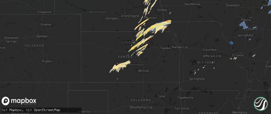
Hail Map in Kansas on May 18, 2026
The weather event in Kansas on May 18, 2026 includes Wind, Hail, and Tornado maps. 19 states and 1,691 cities were impacted and suffered possible damage. The total estimated number of properties impacted is 70,087.
Want more than just the map?
Turn this storm into a full workflow.
- Owner + property data so you know who to knock
- OnDemand branded weather history reports to win the "did we even have hail?" argument
- RoofTrace estimate so reps stop guessing numbers at the door
Bought this map? Upgrade within 7 days and we'll credit the $230. (10-15 min setup call)
Wind
Hail
Tornado
70,087
Estimated number of impacted properties by a 1.00" hail or larger12,538
Estimated number of impacted properties by a 1.75" hail or larger0
Estimated number of impacted properties by a 2.50" hail or largerStorm reports in Kansas
Kansas
| Date | Description |
|---|---|
| 05/18/20266:49 PM CDT | Measured on a personal weather station. |
| 05/18/20266:47 PM CDT | A local report indicates 1.00 inch wind near Arlington |
| 05/18/20266:42 PM CDT | Report from mping: quarter |
| 05/18/20266:41 PM CDT | Personal weather station. |
| 05/18/20266:32 PM CDT | A local report indicates 2.00 inch wind near 7 ESE Inman |
| 05/18/20266:30 PM CDT | A local report indicates 1.50 inch wind near 2 WNW Hutchinson |
| 05/18/20266:29 PM CDT | A local report indicates 1.50 inch wind near 2 SW Inman |
| 05/18/20266:28 PM CDT | A local report indicates 67 MPH wind near 3 N Manhattan |
| 05/18/20266:23 PM CDT | Picture of a 6 foot diameter tree limb across leavenworth street. Time estimated from radar. |
| 05/18/20266:22 PM CDT | A local report indicates 65 MPH wind near Ogden |
| 05/18/20266:20 PM CDT | Twitter report. |
| 05/18/20266:20 PM CDT | A local report indicates 1.00 inch wind near Inman |
| 05/18/20266:17 PM CDT | Report from mping: quarter |
| 05/18/20266:17 PM CDT | A local report indicates 59 MPH wind near 7 WNW Haven |
| 05/18/20266:17 PM CDT | A local report indicates 63 MPH wind near 1 NW Moundridge |
| 05/18/20266:15 PM CDT | A local report indicates 1.00 inch wind near 1 NNE Hutchinson |
| 05/18/20266:10 PM CDT | Report from mping: quarter |
| 05/18/20266:10 PM CDT | Delayed report... Location and time estimated from radar. An 80 year old barn was completely destroyed near abbyville... With some other damage to various outbuildings. |
| 05/18/20266:00 PM CDT | Social media report of quarter-size hail. |
| 05/18/20266:00 PM CDT | Facebook report of large branches down in north hutchinson. |
| 05/18/20265:56 PM CDT | Public report estimated near 70 mph winds ahead of the ma |
| 05/18/20265:56 PM CDT | Public report estimated near 70 mph winds ahead of the main line of storms. |
| 05/18/20265:55 PM CDT | A local report indicates 70 MPH wind near 3 SSE Willowbrook |
| 05/18/20265:53 PM CDT | 80 year old barn destroyed. |
| 05/18/20265:53 PM CDT | Storm chaser saw the tornado pass in front of them. They are seeing damage of grain bins in fields... Power lines down and tree damage. |
| 05/18/20265:38 PM CDT | Social media report with picture. |
| 05/18/20265:38 PM CDT | Damage reported by em of grain bins and trees. |
| 05/18/20265:30 PM CDT | Nws employee confirmed a brief tornado just north of wakefield. |
| 05/18/20265:27 PM CDT | Confirmation of a tornado. |
| 05/18/20265:15 PM CDT | Multiple storm chasers confirm a tornado on the ground south of waterville via social media. |
| 05/18/20265:11 PM CDT | Reported nickel to quarter-size hail. |
| 05/18/20265:05 PM CDT | Social media report of half dollar sized hail. |
| 05/18/20264:46 PM CDT | Report from mping: quarter |
| 05/18/20264:37 PM CDT | Social media report of quarter-sized hail. |
| 05/18/20264:32 PM CDT | A local report indicates 1.00 inch wind near 5 SSE Wells |
| 05/18/20264:30 PM CDT | Report from mping: quarter |
| 05/18/20264:28 PM CDT | Report from mping: half dollar |
| 05/18/20264:23 PM CDT | Social media report of half-dollar sized hail in kinsley with picture. |
| 05/18/20264:15 PM CDT | A local report indicates 1.25 inch wind near Summerfield |
| 05/18/20264:04 PM CDT | Spotter reports damage to trees around intersection of hwy 9 and hwy 15. |
| 05/18/20264:03 PM CDT | Mping report of quarter sized hail. |
| 05/18/20264:03 PM CDT | Social media photo of a tornado. Media confirmed the report. |
| 05/18/20263:57 PM CDT | Social media report of golf ball sized hail with photo. |
| 05/18/20263:50 PM CDT | A local report indicates 1.00 inch wind near Miltonvale |
| 05/18/20263:50 PM CDT | Report from mping: quarter |
| 05/18/20263:49 PM CDT | Social media report of quarter-size hail. |
| 05/18/20263:45 PM CDT | Report from mping: quarter |
| 05/18/20263:40 PM CDT | Public social media report of golf ball sized hail on the northeast side of offerle. |
| 05/18/20263:30 PM CDT | Delayed report of a rope tornado near idana at 3:30. Photos sent via social media. |
| 05/18/20262:01 PM CDT | Storm chaser also reported a low hanging wall cloud. |
| 05/18/20261:58 PM CDT | Near 14 hwy and jaguar rd. |
| 05/18/20261:57 PM CDT | A local report indicates 2.00 inch wind near Lincoln |
| 05/18/20261:51 PM CDT | A local report indicates 1.00 inch wind near 3 S Jamestown |
| 05/18/202612:35 AM CDT | Reports of nickel to quarter size hail and 52 mph wind. |
| 05/18/202612:33 AM CDT | Multiple reports of tree limbs down and power outages. |
| 05/18/202612:12 AM CDT | Kwld measured 67 mph. |
| 05/18/202612:12 AM CDT | Estimated 60-70 mph and dime size hail. |
| 05/18/202612:12 AM CDT | Corrects previous tstm wnd gst report from 4 sw winfield. Estimated 60-70 mph and dime size hail. |
| 05/17/202611:06 PM CDT | Report from mping: quarter |
| 05/17/202611:05 PM CDT | Mping report. Tree |
| 05/17/202611:02 PM CDT | A local report indicates 1.00 inch wind near Wellington |
| 05/17/202610:57 PM CDT | Report from mping: ping pong ball |
| 05/17/202610:44 PM CDT | Wind damage to an old school house in milan. |
| 05/17/202610:37 PM CDT | Report from mping: golf ball |
| 05/17/202610:26 PM CDT | Dimes with some quarters. |
| 05/17/202610:26 PM CDT | Downed wires near 383rd street. Time estimated from radar. |
| 05/17/202610:20 PM CDT | Personal weather station. Delayed report. |
| 05/17/202610:10 PM CDT | Downed wires near 367th street. Time estimated from radar. |
| 05/17/202610:10 PM CDT | Downed wires near stephens street. Time confirmed from radar. |
| 05/17/20269:59 PM CDT | A local report indicates 65 MPH wind near Conway Springs |
| 05/17/20269:46 PM CDT | Multiple reports of downed wires and power outages north of louisburg. Time estimated from radar. |
| 05/17/20269:45 PM CDT | A local report indicates 60 MPH wind near 2 SE Norwich |
| 05/17/20269:41 PM CDT | A local report indicates 59 MPH wind near 3 ESE Bel Aire |
| 05/17/20269:30 PM CDT | Large tree branch downed in yard. Time estimate from radar. |
| 05/17/20269:29 PM CDT | Downed tree and wires near manor road. Time estimated from radar. |
| 05/17/20269:29 PM CDT | Downed tree and wires near 98th street. Time estimated from radar. |
| 05/17/20269:26 PM CDT | Downed tree and wires near 44th street. Time estimated from radar. |
| 05/17/20269:26 PM CDT | Downed tree and wires near 43rd street. Time estimated from radar. |
| 05/17/20269:26 PM CDT | Em relayed spotter report of 70 mph winds. |
| 05/17/20269:26 PM CDT | Downed tree and wires near outlook street. Time confirmed from radar. |
| 05/17/20269:25 PM CDT | A local report indicates 60 MPH wind near 2 SSE East Wichita |
| 05/17/20269:24 PM CDT | Report of downed tree knocking down a street light. Time estimated from radar. |
| 05/17/20269:24 PM CDT | Downed tree and wires near 61st terrace. Time estimated from radar. |
| 05/17/20269:24 PM CDT | Downed tree and wires near 65th terrace. Time estimated from radar. |
| 05/17/20269:24 PM CDT | Downed tree and wires near 33rd terrace. Time estimated from radar. |
| 05/17/20269:23 PM CDT | Large tree downed near 72nd and quivira. Time estimated from radar. |
| 05/17/20269:23 PM CDT | Several power poles snapped near u.s. Highway 169 between 191st and 199th street. Time estimated from radar. |
| 05/17/20269:22 PM CDT | Downed tree and wires near klamm road. Time confirmed from radar. |
| 05/17/20269:22 PM CDT | Downed tree and wires near haskell avenue. Time estimated from radar. |
| 05/17/20269:22 PM CDT | Downed tree and wires near 83rd street. Time estimated from radar. |
| 05/17/20269:21 PM CDT | Public shared video online of large tree branches down... Reporting downed power lines. Time estimated from radar. |
| 05/17/20269:21 PM CDT | Photo relayed via social media of large tree branch down. Time estimated from radar. |
| 05/17/20269:21 PM CDT | Photo relayed via social media of a large tree branch down... Time estimated from radar. |
| 05/17/20269:20 PM CDT | Downed tree and wires near noreson street. Time estimated from radar. |
| 05/17/20269:17 PM CDT | Large tree down on a house near 46th and gibbs. Time confirmed from radar. |
| 05/17/20269:17 PM CDT | A local report indicates 60 MPH wind near Park City |
| 05/17/20269:15 PM CDT | 60-70 mph; time estimated from radar. |
| 05/17/20269:15 PM CDT | Pws measured 63 mph wind gust. |
| 05/17/20269:15 PM CDT | A local report indicates 60 MPH wind near Maize |
| 05/17/20269:14 PM CDT | Downed tree at a residence in kansas city... Ks. Time estimated from radar. |
| 05/17/20269:13 PM CDT | Em relayed spotter report of 84 mph wind gust. |
| 05/17/20269:11 PM CDT | Em relayed spotter measured 77 mph wind gust. |
| 05/17/20269:10 PM CDT | Private weather sensor. |
| 05/17/20269:09 PM CDT | Em relayed 72 mph wind gusts. |
| 05/17/20269:09 PM CDT | Pws measured 70 mph wind gust. |
| 05/17/20269:06 PM CDT | Downed wires near 167th street. Time estimated from radar. |
| 05/17/20269:05 PM CDT | Em relayed 60 mph wind gust. |
| 05/17/20269:02 PM CDT | Pws measured 61 mph gusts. |
| 05/17/20269:02 PM CDT | Corrects previous tstm wnd gst report from 2 ene jarbalo. Pws measured 61 mph gusts. |
| 05/17/20268:55 PM CDT | Em relayed 92 winds. |
| 05/17/20268:54 PM CDT | Prviate weather sensor. |
| 05/17/20268:52 PM CDT | Power line fallen on trees. Time estimated from radar. Report relayed via social media. |
| 05/17/20268:50 PM CDT | Delayed report. Branches down... Largest one 8 inches in diameter. Time estimated from radar. |
| 05/17/20268:49 PM CDT | Delayed report. Wooden play set broken and rolled 10 yards. Time estimated from radar. |
| 05/17/20268:48 PM CDT | Personal weather station. |
| 05/17/20268:46 PM CDT | Time estimated from radar. |
| 05/17/20268:34 PM CDT | 50-60 mph driving down hwy 75. |
| 05/17/20268:34 PM CDT | Personal weather station. |
| 05/17/20268:34 PM CDT | A local report indicates 63 MPH wind near 2 NNE Grantville |
| 05/17/20268:32 PM CDT | Kfoe asos. |
| 05/17/20268:30 PM CDT | Spotter driving through storm... Lots of hail up to quarter size. |
| 05/17/20268:26 PM CDT | Lots of hail... Up to quarter size hail. |
| 05/17/20268:21 PM CDT | A local report indicates 65 MPH wind near Topeka |
| 05/17/20268:20 PM CDT | Kfoe asos. |
| 05/17/20268:18 PM CDT | A local report indicates 65 MPH wind near 7 WSW Topeka |
| 05/17/20268:17 PM CDT | Personal weather station. |
| 05/17/20268:05 PM CDT | A local report indicates 65 MPH wind near 2 NW Dover |
| 05/17/20268:02 PM CDT | Tree down across route 7 north of atchison. Time estimated from radar. |
| 05/17/20267:56 PM CDT | Asos station kp28 medicine lodge. |
| 05/17/20267:53 PM CDT | Kewk asos report. |
| 05/17/20267:51 PM CDT | A local report indicates 80 MPH wind near 1 E Council Grove |
| 05/17/20267:41 PM CDT | A local report indicates 69 MPH wind near 1 SW North Newton |
| 05/17/20267:41 PM CDT | Delayed report. 12 to 16 inch diameter tree trunk snapped. Several tree limbs down. Time estimated from radar. |
| 05/17/20267:39 PM CDT | Several reports of downed wires and power outages north and northwest of muscotah. Time estimated from radar. |
| 05/17/20267:37 PM CDT | A local report indicates 1.00 inch wind near 2 S Halstead |
| 05/17/20267:34 PM CDT | A local report indicates 1.50 inch wind near 6 NNW Volland |
| 05/17/20267:30 PM CDT | Facebook report. |
| 05/17/20267:26 PM CDT | Measured on a personal weather station. |
| 05/17/20267:19 PM CDT | Reports of tree and shingles damage. |
| 05/17/20267:17 PM CDT | Power line down; time estimated from radar. |
| 05/17/20267:15 PM CDT | Damage to home... Barn... And trees. |
| 05/17/20267:15 PM CDT | Barn destroyed. |
| 05/17/20267:12 PM CDT | Grain bin... Hog barn... Large limbs damaged. Time estimated from radar. |
| 05/17/20267:01 PM CDT | Damage to hay barn. Time estimated from radar. |
| 05/17/20267:00 PM CDT | 911 report of power lines down. |
All States Impacted by Hail Map on May 18, 2026
Cities Impacted by Hail Map on May 18, 2026
- Nebo, IL
- Kampsville, IL
- Hamburg, IL
- Eldred, IL
- Pearl, IL
- White Hall, IL
- Boelus, NE
- Canton, IL
- Lewistown, IL
- Liverpool, IL
- Topeka, IL
- Havana, IL
- Manito, IL
- Glasford, IL
- Forest City, IL
- Pekin, IL
- Green Valley, IL
- Kingston Mines, IL
- Mapleton, IL
- Peoria, IL
- San Jose, IL
- Mason City, IL
- Easton, IL
- Hartsburg, IL
- New Holland, IL
- South Pekin, IL
- Emden, IL
- Delavan, IL
- Roanoke, IL
- Clinton, IL
- Waynesville, IL
- Wapella, IL
- Dewitt, IL
- Farmer City, IL
- Le Roy, IL
- Taylorville, IL
- Palmer, IL
- Centralia, IL
- Odin, IL
- Salem, IL
- Morris, IL
- Minooka, IL
- Catawissa, MO
- Robertsville, MO
- Pacific, MO
- Cedar Hill, MO
- House Springs, MO
- Collinsville, IL
- Imperial, MO
- Fenton, MO
- New Lenox, IL
- Mokena, IL
- Oak Lawn, IL
- Chicago Ridge, IL
- Tinley Park, IL
- Hometown, IL
- Orland Park, IL
- Alsip, IL
- Evergreen Park, IL
- Chicago, IL
- Palos Heights, IL
- Palos Park, IL
- Bridgeview, IL
- Palos Hills, IL
- Worth, IL
- Burbank, IL
- Cicero, IL
- Riverside, IL
- Hickory Hills, IL
- La Grange, IL
- Justice, IL
- Berwyn, IL
- Summit Argo, IL
- Lyons, IL
- Willow Springs, IL
- Oak Park, IL
- Highland, IN
- Calumet City, IL
- Markham, IL
- Midlothian, IL
- Dolton, IL
- Country Club Hills, IL
- Gary, IN
- Homewood, IL
- Whiting, IN
- Thornton, IL
- Frankfort, IL
- Munster, IN
- Olympia Fields, IL
- Flossmoor, IL
- Hazel Crest, IL
- Chicago Heights, IL
- South Holland, IL
- East Chicago, IN
- Oak Forest, IL
- Harvey, IL
- Hammond, IN
- Crestwood, IL
- Robbins, IL
- Matteson, IL
- Glenwood, IL
- Lansing, IL
- Blue Island, IL
- Posen, IL
- Riverdale, IL
- Homer Glen, IL
- Griffith, IN
- Park Forest, IL
- Steger, IL
- Richton Park, IL
- University Park, IL
- Monee, IL
- Arnold, MO
- Saint Louis, MO
- Schererville, IN
- Dyer, IN
- Saint John, IN
- Crete, IL
- Merrillville, IN
- Cedar Lake, IN
- Lowell, IN
- Crown Point, IN
- Momence, IL
- Grant Park, IL
- Bradley, IL
- Bourbonnais, IL
- Pembroke Township, IL
- Manteno, IL
- Saint Anne, IL
- Kankakee, IL
- Beecher, IL
- Aroma Park, IL
- Chebanse, IL
- Lake Village, IN
- Schneider, IN
- Hebron, IN
- Hobart, IN
- Lake Station, IN
- Portage, IN
- Valparaiso, IN
- Westville, IN
- Chesterton, IN
- Union Mills, IN
- Wanatah, IN
- Kouts, IN
- Boone Grove, IN
- Kingsford Heights, IN
- La Porte, IN
- Hamlet, IN
- Michigan City, IN
- La Crosse, IN
- Hanna, IN
- Knox, IN
- Beverly Shores, IN
- Noel, MO
- New Buffalo, MI
- Lakeside, MI
- Rolling Prairie, IN
- Union Pier, MI
- Three Oaks, MI
- Bridgman, MI
- Sawyer, MI
- Walkerton, IN
- Mill Creek, IN
- Harbert, MI
- New Carlisle, IN
- Galien, MI
- New Troy, MI
- Baroda, MI
- Stevensville, MI
- Buchanan, MI
- North Liberty, IN
- Grovertown, IN
- South Bend, IN
- Saint Joseph, MI
- Berrien Springs, MI
- Niles, MI
- Clay City, IN
- Centerpoint, IN
- Benton Harbor, MI
- Sodus, MI
- Coloma, MI
- Eau Claire, MI
- Berrien Center, MI
- Notre Dame, IN
- Liberal, MO
- Granger, IN
- Mishawaka, IN
- Louisburg, MO
- Urbana, MO
- Half Way, MO
- Dowagiac, MI
- Watervliet, MI
- Bangor, MI
- Decatur, MI
- Covert, MI
- Hartford, MI
- South Haven, MI
- Edwardsburg, MI
- Cassopolis, MI
- Bourbon, IN
- Mentone, IN
- Tippecanoe, IN
- Rochester, IN
- Akron, IN
- Claypool, IN
- Etna Green, IN
- Warsaw, IN
- Lawton, MI
- Lawrence, MI
- Marcellus, MI
- Paw Paw, MI
- Vandalia, MI
- Kingsley, MI
- Traverse City, MI
- Williamsburg, MI
- South Boardman, MI
- Kalkaska, MI
- Grand Junction, MI
- Allegan, MI
- Bloomingdale, MI
- Pullman, MI
- Fennville, MI
- Leesburg, IN
- Atwood, IN
- Gobles, MI
- Jones, MI
- Schoolcraft, MI
- Mattawan, MI
- Kalamazoo, MI
- Simpson, KS
- Vanderbilt, MI
- Elmira, MI
- Hamilton, MI
- Otsego, MI
- Hopkins, MI
- Marco Island, FL
- Jamestown, KS
- Gaylord, MI
- Dorr, MI
- Martin, MI
- Shelbyville, MI
- Wayland, MI
- Wilson, KS
- Sylvan Grove, KS
- Ashmore, IL
- Concordia, KS
- Scandia, KS
- Norway, KS
- Bolivar, MO
- Aldrich, MO
- Walnut Grove, MO
- Morrisville, MO
- Plainwell, MI
- Portage, MI
- Vicksburg, MI
- Lincoln, KS
- Hastings, MI
- Claflin, KS
- Mendon, MI
- Leonidas, MI
- Milan, MI
- Colon, MI
- Sherwood, MI
- Richland, MI
- Grandville, MI
- Rockford, MI
- Grand Rapids, MI
- Caledonia, MI
- Belmont, MI
- Wyoming, MI
- Byron Center, MI
- Cedar Springs, MI
- Middleville, MI
- Ada, MI
- Comstock Park, MI
- Hudsonville, MI
- Allendale, MI
- Zeeland, MI
- Marne, MI
- Jenison, MI
- Lake Odessa, MI
- Dowling, MI
- Climax, MI
- Ceresco, MI
- Galesburg, MI
- Bellevue, MI
- Scotts, MI
- Lowell, MI
- Augusta, MI
- Freeport, MI
- Nashville, MI
- Delton, MI
- Alto, MI
- Battle Creek, MI
- Hickory Corners, MI
- East Leroy, MI
- Clarksville, MI
- Marshall, MI
- Holyrood, KS
- Hebron, NE
- Deshler, NE
- Washington, KS
- Fenwick, MI
- Saranac, MI
- Olivet, MI
- Sheridan, MI
- Sidney, MI
- Gowen, MI
- Woodland, MI
- Vermontville, MI
- Stanton, MI
- Greenville, MI
- Orleans, MI
- Ionia, MI
- Belding, MI
- Sand Lake, MI
- Trufant, MI
- Homer, MI
- Albion, MI
- Charlotte, MI
- Sunfield, MI
- Tekonsha, MI
- Burlington, MI
- Coldwater, MI
- Kendallville, IN
- Howe, IN
- Athens, MI
- Auburn, IN
- Pleasant Lake, IN
- Lagrange, IN
- Huntertown, IN
- Angola, IN
- Hudson, IN
- Bronson, MI
- Avilla, IN
- Garrett, IN
- Fremont, IN
- Fort Wayne, IN
- Corunna, IN
- Quincy, MI
- Laotto, IN
- Ashley, IN
- Wolcottville, IN
- Union City, MI
- Orland, IN
- Waterloo, IN
- Montgomery, MI
- New Haven, IN
- Antwerp, OH
- Harlan, IN
- Convoy, OH
- Saint Joe, IN
- Leo, IN
- Reading, MI
- Hamilton, IN
- Spencerville, IN
- Hoagland, IN
- Woodburn, IN
- Hicksville, OH
- Grabill, IN
- Monroeville, IN
- Butler, IN
- Payne, OH
- Edon, OH
- Paulding, OH
- Scott, OH
- Cecil, OH
- Montpelier, OH
- Haviland, OH
- Defiance, OH
- Grover Hill, OH
- Bryan, OH
- Litchfield, MI
- Mark Center, OH
- Fort Jennings, OH
- Camden, MI
- Van Wert, OH
- Ney, OH
- Ottoville, OH
- Hillsdale, MI
- Oakwood, OH
- Melrose, OH
- Pioneer, OH
- Sherwood, OH
- Latty, OH
- Cloverdale, OH
- Edgerton, OH
- Allen, MI
- Middle Point, OH
- Willis, MI
- Rome City, IN
- Burr Oak, MI
- Albion, IN
- Arcola, IN
- South Milford, IN
- Churubusco, IN
- Fulton, MI
- Sturgis, MI
- Three Rivers, MI
- Centreville, MI
- Wawaka, IN
- Columbia City, IN
- Kimmell, IN
- Topeka, IN
- Shipshewana, IN
- Goshen, IN
- Millersburg, IN
- Constantine, MI
- Middlebury, IN
- Ligonier, IN
- White Pigeon, MI
- Belvidere, NE
- Hollenberg, KS
- Morrowville, KS
- Belleville, KS
- Barnard, KS
- Haddam, KS
- Cromwell, IN
- Mahaska, KS
- Pierceton, IN
- Larwill, IN
- Zionsville, IN
- Sheridan, IN
- Westfield, IN
- Carleton, NE
- Beloit, KS
- Stryker, OH
- Archbold, OH
- Evansport, OH
- Endicott, NE
- Steele City, NE
- Diller, NE
- Lyons, OH
- Hillman, MI
- Lyons, MI
- Portland, MI
- Agenda, KS
- Mulliken, MI
- Atlanta, MI
- Clifton, KS
- Napoleon, OH
- Minneapolis, KS
- Eaton Rapids, MI
- West Unity, OH
- Concord, MI
- Muir, MI
- Springport, MI
- Hanover, MI
- Grand Ledge, MI
- Osseo, MI
- Jonesville, MI
- Carson City, MI
- Onondaga, MI
- Dimondale, MI
- Okemos, MI
- Spring Arbor, MI
- Eagle, MI
- Clarklake, MI
- Fowler, MI
- Rives Junction, MI
- Parma, MI
- Jerome, MI
- Haslett, MI
- Potterville, MI
- North Adams, MI
- Horton, MI
- East Lansing, MI
- Hubbardston, MI
- Jackson, MI
- Westphalia, MI
- Saint Johns, MI
- Bath, MI
- Dewitt, MI
- Laingsburg, MI
- Lansing, MI
- Pewamo, MI
- Alvordton, OH
- Pittsford, MI
- Waldron, MI
- Mason, MI
- Holt, MI
- Leslie, MI
- Jasper, MI
- Fairbury, NE
- Cuba, KS
- Lachine, MI
- Fort Stockton, TX
- Delphos, KS
- Beverly, KS
- Iraan, TX
- Glasco, KS
- Jansen, NE
- Beatrice, NE
- Odell, NE
- Delta, OH
- Alpena, MI
- Narka, KS
- Blue Springs, NE
- Aurora, KS
- Miltonvale, KS
- Eldridge, MO
- Dixon, MO
- Meta, MO
- Brinktown, MO
- Camdenton, MO
- Linn Creek, MO
- Clyde, KS
- Filley, NE
- Burton, MI
- Flint, MI
- Lorraine, KS
- Wymore, NE
- Mathias, WV
- Baker, WV
- Tescott, KS
- Pickrell, NE
- Adams, NE
- Crab Orchard, NE
- Tecumseh, NE
- Offerle, KS
- Davison, MI
- Spearville, KS
- Kinsley, KS
- Mount Vernon, IN
- Virginia, NE
- Kanopolis, KS
- Ellsworth, KS
- Morganville, KS
- Bucklin, KS
- Schuyler, NE
- Bee, NE
- Valparaiso, NE
- Howells, NE
- Clarkson, NE
- Lewis, KS
- Sterling, NE
- Steinauer, NE
- Leigh, NE
- Lewiston, NE
- Garfield, KS
- Larned, KS
- Fairmont, NE
- Ford, KS
- De Witt, NE
- Brookville, KS
- Clay Center, KS
- Hanover, KS
- Wisner, NE
- Pilger, NE
- Stanton, NE
- Liberty, NE
- Burchard, NE
- Pawnee City, NE
- Wright, KS
- Dodge City, KS
- Beemer, NE
- Dodge, NE
- West Point, NE
- Ortonville, MI
- Hamburg, MI
- White Lake, MI
- Grand Blanc, MI
- Hadley, MI
- Bancroft, MI
- Linden, MI
- Brighton, MI
- Swartz Creek, MI
- Perry, MI
- Davisburg, MI
- Stockbridge, MI
- Clarkston, MI
- Highland, MI
- Norvell, MI
- Lapeer, MI
- Pleasant Lake, MI
- Gaines, MI
- Whitmore Lake, MI
- Grass Lake, MI
- Hudson, MI
- Webberville, MI
- Hartland, MI
- Napoleon, MI
- Clayton, MI
- Byron, MI
- Gregory, MI
- Munith, MI
- Goodrich, MI
- Dexter, MI
- Cement City, MI
- Michigan Center, MI
- Somerset Center, MI
- Manitou Beach, MI
- Dansville, MI
- Williamston, MI
- Pinckney, MI
- Howell, MI
- Milford, MI
- Attica, MI
- Adrian, MI
- Addison, MI
- Atlas, MI
- Fenton, MI
- Morrice, MI
- Owosso, MI
- Manchester, MI
- Ann Arbor, MI
- Durand, MI
- Fowlerville, MI
- Tipton, MI
- Onsted, MI
- Chelsea, MI
- Lennon, MI
- Metamora, MI
- Holly, MI
- Brooklyn, MI
- Beattie, KS
- Cook, NE
- Elk Creek, NE
- Burr, NE
- Table Rock, NE
- Auburn, NE
- Humboldt, NE
- Brock, NE
- Johnson, NE
- Vernon, MI
- Ovid, MI
- Corunna, MI
- Elsie, MI
- Columbiaville, MI
- Flushing, MI
- Du Bois, NE
- Talmage, NE
- Dawson, NE
- Stella, NE
- Staplehurst, NE
- Seward, NE
- Superior, NE
- Summerfield, KS
- Home, KS
- Weston, NE
- Dwight, NE
- Salina, KS
- McCool Junction, NE
- Waco, NE
- York, NE
- Oketo, KS
- Star Tannery, VA
- Clinton, MI
- Northville, MI
- Sand Creek, MI
- Wixom, MI
- New Hudson, MI
- Morenci, MI
- Tecumseh, MI
- Commerce Township, MI
- Fayette, OH
- Saline, MI
- Waterford, MI
- Britton, MI
- Palmyra, MI
- South Lyon, MI
- Oxford, MI
- Oak, NE
- Davenport, NE
- Livonia, MI
- Plymouth, MI
- Oakland, MI
- Dearborn Heights, MI
- Canton, MI
- Farmington, MI
- Blissfield, MI
- Newport, MI
- Detroit, MI
- Southfield, MI
- Westland, MI
- Pontiac, MI
- Redford, MI
- Taylor, MI
- Rockwood, MI
- Lake Orion, MI
- Dryden, MI
- Maybee, MI
- Petersburg, MI
- Keego Harbor, MI
- Auburn Hills, MI
- Birmingham, MI
- Carleton, MI
- Dearborn, MI
- Monroe, MI
- Rochester, MI
- Inkster, MI
- Ida, MI
- Garden City, MI
- Flat Rock, MI
- Romulus, MI
- West Bloomfield, MI
- Ypsilanti, MI
- Franklin, MI
- Novi, MI
- Wayne, MI
- Dundee, MI
- Belleville, MI
- Bloomfield Hills, MI
- Deerfield, MI
- Walled Lake, MI
- South Rockwood, MI
- New Boston, MI
- Nelson, NE
- Greenleaf, KS
- Palmer, KS
- Winchester, VA
- Strasburg, VA
- Courtland, KS
- Hubbell, NE
- Munden, KS
- Morse Bluff, NE
- Cedar Bluffs, NE
- Almont, MI
- Lindsborg, KS
- Brainard, NE
- David City, NE
- North Bend, NE
- Prague, NE
- Malmo, NE
- Bennington, KS
- Metamora, OH
- Riga, MI
- Ames, NE
- Ruskin, NE
- Ottawa Lake, MI
- Berkey, OH
- Surprise, NE
- Quanah, TX
- Swanton, OH
- Ulysses, NE
- Chester, NE
- Bancroft, NE
- Pender, NE
- Gresham, NE
- Falun, KS
- Bruno, NE
- Shickley, NE
- Eldorado, OK
- Gould, OK
- Duke, OK
- Bern, KS
- Sabetha, KS
- Brownville, NE
- Peru, NE
- Julian, NE
- Walthill, NE
- Solomon, KS
- Rising City, NE
- Strang, NE
- Bruning, NE
- Green, KS
- Hooper, NE
- Winslow, NE
- Fremont, NE
- Stephens City, VA
- Middletown, VA
- Geneva, NE
- Reynolds, NE
- Nebraska City, NE
- Rock Port, MO
- Linwood, NE
- La Salle, MI
- Shubert, NE
- Watson, MO
- Nemaha, NE
- Temperance, MI
- Ohiowa, NE
- Tobias, NE
- Milligan, NE
- River Rouge, MI
- Imlay City, MI
- Sterling Heights, MI
- Ferndale, MI
- Washington, MI
- Ecorse, MI
- Trenton, MI
- Romeo, MI
- Madison Heights, MI
- Pleasant Ridge, MI
- Royal Oak, MI
- Highland Park, MI
- Wyandotte, MI
- Grosse Ile, MI
- Lincoln Park, MI
- Warren, MI
- Hazel Park, MI
- Southgate, MI
- Utica, MI
- Center Line, MI
- Melvindale, MI
- Huntington Woods, MI
- Leonard, MI
- Riverview, MI
- Oak Park, MI
- Clawson, MI
- Hamtramck, MI
- Allen Park, MI
- Berkley, MI
- Troy, MI
- Coldwater, KS
- Belpre, KS
- St John, KS
- Hamburg, IA
- Alexandria, NE
- Herman, NE
- Craig, NE
- Tekamah, NE
- Oakland, NE
- Bellwood, NE
- Macksville, KS
- Columbus, NE
- Abilene, KS
- New Cambria, KS
- Longford, KS
- Hudson, KS
- Gerrardstown, WV
- Rogers, NE
- Verdon, NE
- Farragut, IA
- Riverton, IA
- Northboro, IA
- Shenandoah, IA
- Creston, NE
- Newburg, MO
- Duke, MO
- Hawarden, IA
- Hornick, IA
- Salix, IA
- Bronson, IA
- Sloan, IA
- Winnebago, NE
- Assaria, KS
- Onawa, IA
- Whiting, IA
- Decatur, NE
- Friend, NE
- Westboro, MO
- Barnes, KS
- Gypsum, KS
- Linn, KS
- Waterville, KS
- Western, NE
- Daykin, NE
- Tarkio, MO
- Marysville, KS
- Wakefield, KS
- Capac, MI
- Emmett, MI
- Allenton, MI
- Yale, MI
- Scribner, NE
- Dorchester, NE
- Greensburg, KS
- Akron, IA
- Westfield, IA
- Hastings, IA
- Emerson, IA
- Brown City, MI
- Melvin, MI
- Avoca, MI
- Coin, IA
- Randolph, KS
- Falls City, NE
- Crete, NE
- Pleasant Dale, NE
- Milford, NE
- Denton, NE
- Mangum, OK
- Haviland, KS
- Raymond, KS
- Alden, KS
- Sylvia, KS
- Rock Valley, IA
- Exeter, NE
- Climbing Hill, IA
- Smithland, IA
- Correctionville, IA
- Anthon, IA
- Moville, IA
- Oto, IA
- Lyons, NE
- Blanchard, IA
- Snyder, NE
- Stafford, KS
- Talmage, KS
- Red Oak, IA
- Armada, MI
- Sterling, KS
- Ellinwood, KS
- Byers, KS
- Blue Rapids, KS
- Rodney, IA
- Fairfax, MO
- Beaver Crossing, NE
- Carter, OK
- Dill City, OK
- Elk City, OK
- Quimby, IA
- Washta, IA
- Pierson, IA
- Holstein, IA
- Cushing, IA
- Macy, NE
- Uehling, NE
- Cherokee, IA
- Aurelia, IA
- Wayne, NE
- Clarinda, IA
- Elmo, MO
- Wakefield, NE
- College Springs, IA
- Utica, NE
- Goehner, NE
- Lyons, KS
- Chase, KS
- Plevna, KS
- Junction City, KS
- Milford, KS
- Chapman, KS
- Elliott, IA
- Griswold, IA
- Rosalie, NE
- Syracuse, NE
- Alton, IA
- Hospers, IA
- Gilead, NE
- Garland, NE
- Braddyville, IA
- Kingsley, IA
- Shambaugh, IA
- Clearmont, MO
- Burlington Junction, MO
- New Market, IA
- Abbyville, KS
- Bedford, IA
- Partridge, KS
- Hutchinson, KS
- Nickerson, KS
- Inman, KS
- South Hutchinson, KS
- Allen, NE
- Concord, NE
- Ceresco, NE
- Unadilla, NE
- Douglas, NE
- Riley, KS
- Iuka, KS
- Canute, OK
- Pratt, KS
- Frankfort, KS
- Leonardville, KS
- Junction, IL
- Turon, KS
- Sullivan, MO
- Craig, MO
- Dixon, NE
- Little River, KS
- Shawneetown, IL
- Enterprise, KS
- Arlington, KS
- Buhler, KS
- Haven, KS
- Sanborn, IA
- Ponca, NE
- Waterbury, NE
- Corning, IA
- Cumberland, IA
- Sheldon, IA
- Hope, KS
- Fort Riley, KS
- Skidmore, MO
- Wiota, IA
- Sidney, IA
- Archer, IA
- Wahoo, NE
- Windom, KS
- Ocheyedan, IA
- Harris, IA
- Union, NE
- Mcpherson, KS
- Massena, IA
- Sturgis, KY
- Vermillion, KS
- Dunbar, NE
- Morganfield, KY
- Hartley, IA
- Matthews, MO
- Weeping Water, NE
- Avoca, NE
- Butler, OK
- Hopkins, MO
- Axtell, KS
- Lonedell, MO
- Richwoods, MO
- Otoe, NE
- Burrton, KS
- Raymond, NE
- Plymouth, NE
- Elk Point, SD
- Redding, IA
- Sheridan, MO
- Clearfield, IA
- Pickering, MO
- Gravity, IA
- Blockton, IA
- Bridgewater, IA
- Randolph, IA
- Lake Park, IA
- Wilber, NE
- Swanton, NE
- Bertrand, MO
- Lincoln, NE
- Ogden, KS
- Maryville, MO
- Nehawka, NE
- Manhattan, KS
- Woodbine, KS
- Baileyville, KS
- Jefferson, SD
- Marianna, AR
- Seneca, KS
- Uniontown, KY
- Colon, NE
- Fort Calhoun, NE
- Omaha, NE
- Parnell, MO
- Moundridge, KS
- Prescott, IA
- Fontanelle, IA
- Canton, KS
- Galva, KS
- Westmoreland, KS
- Saint George, KS
- Oneida, KS
- Olsburg, KS
- Ong, NE
- Miller City, IL
- Plattsmouth, NE
- Greenfield, IA
- Spirit Lake, IA
- Milford, IA
- Murray, NE
- Malvern, IA
- Tabor, IA
- Glenwood, IA
- Benton, IA
- Grant City, MO
- Ithaca, NE
- Armstrong, IA
- Swea City, IA
- Wamego, KS
- Alma, KS
- Cairo, IL
- Mounds, IL
- Davey, NE
- Onaga, KS
- Herington, KS
- Pretty Prairie, KS
- Waverly, NE
- Centralia, KS
- Durham, KS
- Clatonia, NE
- Earlham, IA
- Bennington, NE
- Dwight, KS
- Alta Vista, KS
- Halstead, KS
- White City, KS
- Hillsboro, KS
- Hesston, KS
- Ledyard, IA
- Havensville, KS
- Corning, KS
- Goff, KS
- Soldier, KS
- Edgar, NE
- Cunningham, KS
- Diagonal, IA
- Blue Earth, MN
- Ashland, NE
- Greenwood, NE
- Salem, NE
- Newton, KS
- Goessel, KS
- Marion, KS
- Afton, IA
- Thayer, IA
- Shannon City, IA
- Ellston, IA
- Tingley, IA
- Mount Ayr, IA
- Persia, IA
- Neola, IA
- Logan, IA
- Ramona, KS
- Lincolnville, KS
- Tampa, KS
- Lost Springs, KS
- Elkhorn, NE
- Missouri Valley, IA
- Honey Creek, IA
- Van Meter, IA
- Winterset, IA
- De Soto, IA
- Belvue, KS
- Mount Hope, KS
- Bremen, KS
- Circleville, KS
- Holton, KS
- Portsmouth, IA
- Emmett, KS
- Saint Marys, KS
- Paxico, KS
- Delia, KS
- Fairview, KS
- Hiawatha, KS
- Blanchard, PA
- Beech Creek, PA
- Howard, PA
- Sedgwick, KS
- Burdick, KS
- Wilsey, KS
- Council Grove, KS
- Walton, KS
- Peabody, KS
- Isabel, KS
- Sun City, KS
- Coats, KS
- Percival, IA
- Prole, IA
- Ida Grove, IA
- Battle Creek, IA
- Mayetta, KS
- Cumming, IA
- West Des Moines, IA
- Norwalk, IA
- Netawaka, KS
- Sawyer, KS
- Wetmore, KS
- Strong City, KS
- Whiting, KS
- Rossville, KS
- Eskridge, KS
- Maple Hill, KS
- Topeka, KS
- McFarland, KS
- Harveyville, KS
- Allen, KS
- Kellerton, IA
- Hatfield, MO
- Grand River, IA
- Americus, KS
- Silver Lake, KS
- White Cloud, KS
- Robinson, KS
- Rulo, NE
- Horton, KS
- Powhattan, KS
- Muscotah, KS
- Kingman, KS
- North Newton, KS
- Nashville, KS
- Cedar Point, KS
- Indianola, IA
- Colwich, KS
- Lancaster, KS
- Everest, KS
- Denison, KS
- Carbondale, KS
- Burlingame, KS
- Reading, KS
- Hoyt, KS
- Wakarusa, KS
- Auburn, KS
- Mound City, MO
- Maitland, MO
- Oregon, MO
- Valley Falls, KS
- Spivey, KS
- Florence, KS
- Elmdale, KS
- Denton, KS
- Effingham, KS
- Highland, KS
- Forest City, MO
- Bendena, KS
- Troy, KS
- Andale, KS
- Zenda, KS
- Bentley, KS
- Ravenwood, MO
- Valley Center, KS
- Meriden, KS
- Berryton, KS
- Atchison, KS
- Wathena, KS
- Saint Joseph, MO
- Elwood, KS
- Cottonwood Falls, KS
- Amazonia, MO
- Fillmore, MO
- Savannah, MO
- Admire, KS
- Emporia, KS
- Bolckow, MO
- Graham, MO
- Barnard, MO
- Scranton, KS
- Nortonville, KS
- Matfield Green, KS
- Burns, KS
- Union Star, MO
- Osage City, KS
- Cosby, MO
- Helena, MO
- Whitewater, KS
- Isanti, MN
- Saint Francis, MN
- Zimmerman, MN
- Rea, MO
- Rosendale, MO
- State Center, IA
- Worth, MO
- Potwin, KS
- Murdock, KS
- Cheney, KS
- Garden Plain, KS
- Tecumseh, KS
- Grantville, KS
- Quenemo, KS
- Overbrook, KS
- Cummings, KS
- King City, MO
- Winchester, KS
- Attica, KS
- McLouth, KS
- El Dorado, KS
- Cassoday, KS
- Oskaloosa, KS
- Ozawkie, KS
- Lawrence, KS
- Lecompton, KS
- Perry, KS
- Easton, KS
- Leavenworth, KS
- Tonganoxie, KS
- Eudora, KS
- Baldwin City, KS
- Lansing, KS
- Pomona, KS
- Bonner Springs, KS
- Ottawa, KS
- De Soto, KS
- Linwood, KS
- Basehor, KS
- Wellsville, KS
- Conception Junction, MO
- Stanberry, MO
- Albany, MO
- Martinsville, MO
- Eagleville, MO
- Ridgeway, MO
- Denver, MO
- New Hampton, MO
- Bethany, MO
- Gentry, MO
- Clyde, MO
- Conception, MO
- Darlington, MO
- Lamoni, IA
- Davis City, IA
- Cainsville, MO
- Blythedale, MO
- Decatur, IA
- Leon, IA
- Gilman City, MO
- Chatsworth, IA
- Princeton, MO
- Wichita, KS
- Maize, KS
- Goddard, KS
- Haysville, KS
- Clearwater, KS
- Jamesport, MO
- Shawnee, KS
- Gardner, KS
- Paola, KS
- Spring Hill, KS
- Edgerton, KS
- New Century, KS
- Olathe, KS
- Platte City, MO
- Rantoul, KS
- Lenexa, KS
- Kansas City, KS
- Harper, KS
- Olpe, KS
- Amity, MO
- Maysville, MO
- Clarksdale, MO
- Pattonsburg, MO
- McFall, MO
- Weatherby, MO
- Coffey, MO
- Jameson, MO
- Kechi, KS
- Mcconnell Afb, KS
- Derby, KS
- Mercer, MO
- Spickard, MO
- Lineville, IA
- Osceola, IA
- Garden Grove, IA
- Weldon, IA
- Van Wert, IA
- Murray, IA
- Humeston, IA
- Trenton, MO
- Madison, KS
- Chariton, IA
- Norwich, KS
- Eureka, KS
- Mondovi, WI
- Easton, MO
- Stewartsville, MO
- Altamont, MO
- Winston, MO
- Gallatin, MO
- Cameron, MO
- Osborn, MO
- Stilwell, KS
- Independence, MO
- Waldron, MO
- Farley, MO
- Liberty, MO
- Bucyrus, KS
- Overland Park, KS
- Prairie Village, KS
- Kansas City, MO
- Mission, KS
- Leawood, KS
- Riverside, MO
- Louisburg, KS
- Rose Hill, KS
- Greenwich, KS
- Towanda, KS
- Andover, KS
- Benton, KS
- Hartford, KS
- Gridley, KS
- Neosho Rapids, KS
- Burlington, KS
- Lebo, KS
- Waverly, KS
- Smithville, MO
- Kearney, MO
- Holt, MO
- Excelsior Springs, MO
- Corydon, IA
- Woodburn, IA
- Allerton, IA
- Clio, IA
- Derby, IA
- Lucas, IA
- Lucerne, MO
- Seymour, IA
- Powersville, MO
- Augusta, KS
- Douglass, KS
- Brooklyn, IA
- Eleva, WI
- Milton, KS
- Plattsburg, MO
- Orrick, MO
- Rayville, MO
- Conway Springs, KS
- Argonia, KS
- Anthony, KS
- Danville, KS
- Viola, KS
- Cleveland, MO
- Blue Springs, MO
- Freeman, MO
- Pleasant Hill, MO
- Missouri City, MO
- Grandview, MO
- Lees Summit, MO
- Peculiar, MO
- Belton, MO
- Raymore, MO
- Harrisonville, MO
- Greenwood, MO
- Oak Grove, MO
- Richmond, MO
- Levasy, MO
- Lawson, MO
- Buckner, MO
- Grain Valley, MO
- Sibley, MO
- Leon, KS
- Rosalia, KS
- Westphalia, KS
- Le Roy, KS
- Unionville, MO
- Promise City, IA
- Millerton, IA
- Russell, IA
- Plano, IA
- Melrose, IA
- Centerville, IA
- Moravia, IA
- Mystic, IA
- Laredo, MO
- Chula, MO
- Chillicothe, MO
- Galt, MO
- Milan, MO
- Humphreys, MO
- Harris, MO
- Browning, MO
- Hamilton, KS
- Milan, KS
- Henrietta, MO
- Hardin, MO
- Camden, MO
- Bates City, MO
- Napoleon, MO
- Odessa, MO
- Wellington, MO
- Lone Jack, MO
- Kingsville, MO
- Lexington, MO
- Dover, MO
- Higginsville, MO
- Holden, MO
- Norborne, MO
- Carrollton, MO
- Mayview, MO
- East Lynne, MO
- Waverly, MO
- Garden City, MO
- Strasburg, MO
- Centerview, MO
- Corder, MO
- Pollock, MO
- Newtown, MO
- Green City, MO
- Warrens, WI
- Black River Falls, WI
- Freeport, KS
- Mayfield, KS
- Wellington, KS
- Virgil, KS
- Peck, KS
- Caldwell, KS
- Laredo, TX
- Belle Plaine, KS
- Mulvane, KS
- Yates Center, KS
- Concordia, MO
- Urich, MO
- Blairstown, MO
- Warrensburg, MO
- Chilhowee, MO
- Creighton, MO
- Leeton, MO
- Knob Noster, MO
- Alma, MO
- Malta Bend, MO
- Udall, KS
- Windsor, MO
- La Monte, MO
- Whiteman Air Force Base, MO
- Sedalia, MO
- Green Ridge, MO
- Calhoun, MO
- Clinton, MO
- Princeton, KS
- Welda, KS
- Richmond, KS
- Garnett, KS
- Colony, KS
- Williamsburg, KS
- South Haven, KS
- Osawatomie, KS
- Greeley, KS
- Lane, KS
- Kincaid, KS
- Montfort, WI
- Cobb, WI
- Friendship, WI
- Arkdale, WI
- Oxford, KS
- Medford, OK
- Ionia, MO
- Lincoln, MO
- Centerville, KS
- Parker, KS
- Fontana, KS
- La Cygne, KS
- Nekoosa, WI
- Atlanta, KS
- Salisbury, MO
- Clifton Hill, MO
- Latham, KS
- Braman, OK
- Cantril, IA
- Piedmont, KS
- Encinal, TX
- Geuda Springs, KS
- Keosauqua, IA
- Burden, KS
- Winfield, KS
- Arkansas City, KS
- Blackwell, OK
- Newkirk, OK
- Ponca City, OK
- Howard, KS
- Grenola, KS
- Bonaparte, IA
- Nardin, OK
- La Belle, MO
- Knox City, MO
- Severy, KS
- Freer, TX
- Realitos, TX
- Cotulla, TX
- Tilden, TX
- Hillsboro, IA
- Farmington, IA
- Rock, KS
- Hunter, OK
- Dexter, KS
- Maple City, KS
- Cambridge, KS
- Lamont, OK
- Cheyenne, OK
- Sayre, OK
- Kaw City, OK
- Cedar Vale, KS
- Wever, IA
- Dallas City, IL
- Fort Madison, IA
- Burbank, OK
- Shidler, OK
- Sedan, KS
- Elk Falls, KS
- Longton, KS
- Moline, KS
- Concepcion, TX
- San Diego, TX
- Oilton, TX
- Mirando City, TX
- Bruni, TX
- Tonkawa, OK
- Benavides, TX
- Clinton, OK
- Hammon, OK
- Odem, TX
- Sinton, TX
- Macomb, IL
- Pawhuska, OK
- Elk City, KS
- Peru, KS
- Alice, TX
- Orange Grove, TX
- Foss, OK
- Robstown, TX
- Agua Dulce, TX
- Bishop, TX
- Mathis, TX
- Taft, TX
- Woodsboro, TX
- Sandia, TX
- Welch, OK
- Nowata, OK
- Gonzales, TX
- Harwood, TX
- Waelder, TX
- Bluejacket, OK
- Miami, OK
- Ingleside, TX
- Haskell, OK
- Bixby, OK
- Coweta, OK
- Broken Arrow, OK
- Council Hill, OK
- Vinita, OK
- Morrill, KS
- Guilford, MO
- Alma, MI
- Ashley, MI
- Ithaca, MI
- Elwell, MI
- Middleton, MI
- Crystal, MI
- Maple Rapids, MI
- Sumner, MI
- Perrinton, MI
- Riverdale, MI
- Pompeii, MI
- North Star, MI
- Brant, MI
- Bannister, MI
- Saint Louis, MI
- Wheeler, MI
- Breckenridge, MI
- Henderson, MI
- Merrill, MI
- Montrose, MI
- New Lothrop, MI
- Chesaning, MI
- Burt, MI
- Mount Morris, MI
- Oakley, MI
- Saginaw, MI
- Hemlock, MI
- Saint Charles, MI
- Otisville, MI
- Genesee, MI
- Frankenmuth, MI
- North Branch, MI
- Birch Run, MI
- Vassar, MI
- Midland, MI
- Clio, MI
- Munger, MI
- Otter Lake, MI
- Bay City, MI
- University Center, MI
- Fostoria, MI
- Millington, MI
- Auburn, MI
- Freeland, MI
- Bridgeport, MI
- Carrollton, MI
- Reese, MI
- Kawkawlin, MI
- Litchfield, IL
- Butler, IL
- Linwood, MI
- Mayville, MI
- Essexville, MI
- Fairgrove, MI
- Akron, MI
- Caro, MI
- Silverwood, MI
- Sebewaing, MI
- Unionville, MI
- Tremont, IL
- Virginia, IL
- Ashland, IL
- Kingston, MI
- Cass City, MI
- Deford, MI
- Clifford, MI
- Stendal, IN
- Huntingburg, IN
- Velpen, IN
- Winslow, IN
- Holland, IN
- Marlette, MI
- Jasper, IN
- Dubois, IN
- Saint Anthony, IN
- French Lick, IN
- Celestine, IN
- Birdseye, IN
- Schnellville, IN
- Eckerty, IN
- English, IN
- Paoli, IN
- Taswell, IN
- Hardinsburg, IN
- Orleans, IN
- Campbellsburg, IN
- Salem, IN
- Decker, MI
- Mill Hall, PA
- Lock Haven, PA
- Elkhart, IN
- Reelsville, IN
- Poland, IN
- Bowling Green, IN
- Cloverdale, IN


