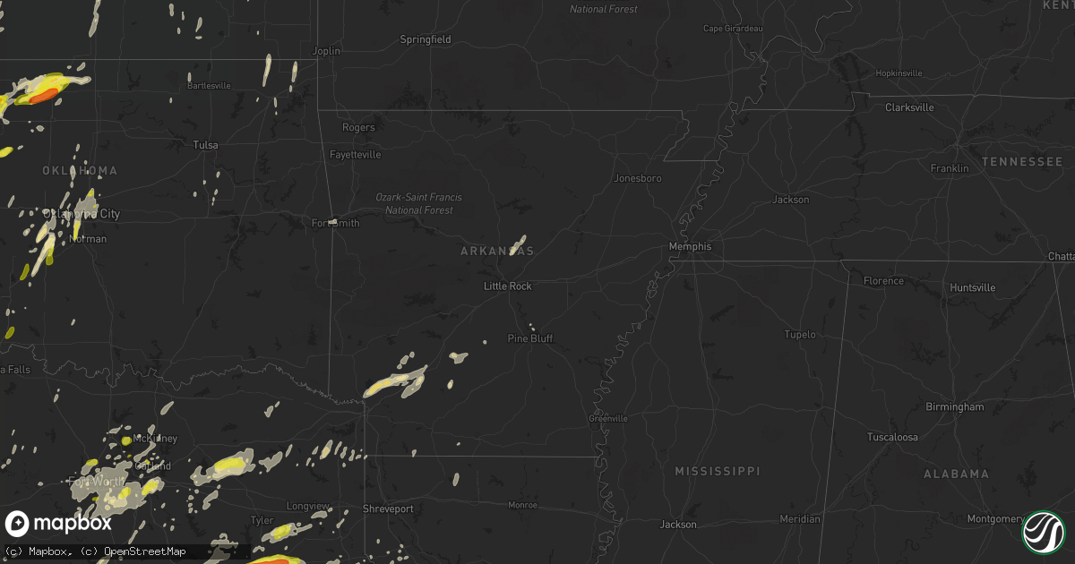
Hail Map in Arkansas on May 18, 2019
Get this storm
May 18 map
$229
one time, instant access
Download today. No call, no setup
Keep the $229
Bought the map and want the full workflow? Apply the entire $229 to a subscription within 7 days. None of it is wasted.
Every map, not just this one
This buys you this map. Subscription and you get every map we run, in the markets you choose from a few cities to whole states to nationwide. Plus real-time alerts the moment a storm fires.
Contact data
Name, contact info, occupancy, even credit band for addresses in the footprint. You go from where it hit to who to call.
Become the source they trust
Unlimited branding weather history reports on demand. You already have the documented answer ready for the property owner, and you are the one who showed up with it.
Property data and RoofTrace estimates
Pull up any address you have got, its value and the exact code rules for that jurisdiction, straight from One Click Code. Then RoofTrace estimates the squares, pitch, and roof value, priced the way you price.
Storm reports in Arkansas
Arkansas
| Date | Description |
|---|---|
| 05/18/20196:24 PM CDT | Winds estimated near 70 mph. |
| 05/18/20196:13 PM CDT | Trees were blown down across hwy 7. All lanes were temporarily blocked. |
| 05/18/20195:55 PM CDT | A weak ef0 tornado has been confirmed near slovak from thunderstorms that occurred saturday evening. Damage was minimal as the tornado remained over mostly farmland. |
| 05/18/20195:54 PM CDT | Limbs and trees down near blakemore. |
| 05/18/20195:48 PM CDT | Powerlines down near the intersection of hwy 381 and hillman road. |
| 05/18/20195:42 PM CDT | Minor structural damage at caney creek baptist church. Along hwy 31 near laster rd. |
| 05/18/20195:37 PM CDT | A tree was blown down on a barn. Trees were also uprooted. |
| 05/18/20195:36 PM CDT | Tree blown over on a house on bowen road near furlow. |
| 05/18/20195:36 PM CDT | Large tree down along hwy 31 at simpson road. |
| 05/18/20195:34 PM CDT | Estimated 60 mph wind gust near the intersection of hwo 31 and simpson rd. In southern lonoke county. |
| 05/18/20195:30 PM CDT | Large tree blown over and blocking stewart road. |
| 05/18/20195:15 PM CDT | Trees were blown down. |
| 05/18/20195:10 PM CDT | A tree was blown down across baseline road. All lanes were temporarily blocked. |
| 05/18/20195:06 PM CDT | The cimarron inn along frontage road sustained roof damage. |
| 05/18/20194:12 PM CDT | Power lines were blown down across hwy 7 near bismarck. |
| 05/18/20194:06 PM CDT | Multiple trees down south of bismarck. |
| 05/18/20194:00 PM CDT | Sheriff department reports numerous trees down across the city of prescott. |
| 05/18/20193:55 PM CDT | Sheriff department reports large tree down across interstate 30 near mile marker 47. |
| 05/18/20193:36 PM CDT | Trees were blown down around harrison. |
| 05/18/20193:15 PM CDT | Trees down. |
| 05/18/20193:00 PM CDT | Tree down on peytonville road in ashdown. |
| 05/18/20192:54 PM CDT | Limbs down in the city of clarksville. |
| 05/18/20192:52 PM CDT | The top half of a tree fell on a house. |
| 05/18/20192:50 PM CDT | Emergency management reported large trees down north of charleston in the highway 60 area. Minor roof damage to some homes in charleston. |
| 05/18/20192:45 PM CDT | A local report indicates 60 MPH wind near SCRANTON |
| 05/18/20192:41 PM CDT | Trees down along main street in coal hill. |
| 05/18/20192:41 PM CDT | Numerous trees down north of subiaco in the patterson bluff area. Time est. From radar. |
| 05/18/20192:40 PM CDT | A local report indicates 60 MPH wind near 2 N SUBIACO |
| 05/18/20192:35 PM CDT | Extensive tree damage atop st. Marys mountain... Around st. Marys catholic church. |
| 05/18/20192:35 PM CDT | A large tree was uprooted. |
| 05/18/20192:33 PM CDT | Numerous trees down in the town of paris. |
| 05/18/20192:30 PM CDT | Tree on a house. Downed trees blocking highway 64. |
| 05/18/20192:30 PM CDT | Tree down on a house and power lines down on north 2nd street. |
| 05/18/20192:25 PM CDT | Trees down across highway 96 in ford hill area. |
| 05/18/20192:25 PM CDT | A tornado uprooted trees and damaged several homes. |
| 05/18/20192:20 PM CDT | Large trees down north of vesta on highway 215. |
| 05/18/20192:20 PM CDT | Tree and outbuilding damage. |
| 05/18/20192:19 PM CDT | Measured gust at fayetteville asos of 54 kt. |
| 05/18/20192:10 PM CDT | A tornado uprooted trees and damaged homes. |
| 05/18/20192:10 PM CDT | Emergency management reported extensive damage to residence in lavaca on south river road and trees fallen in multiple directions. |
| 05/18/20192:05 PM CDT | Interstate sign snapped and thrown into the middle of interstate 540 just south of the zero street exit in fort smith. |
| 05/18/20192:05 PM CDT | Power lines and transformer downed near barling. Picture received via social media. |
| 05/18/20192:04 PM CDT | A tornado uprooted trees and damaged homes. |
| 05/18/20192:02 PM CDT | Trees and power lines down. |
| 05/18/20192:00 PM CDT | Numerous roads blocked throughout franklin county due to downed trees and power lines. Multiple homes throughout the county damaged by downed trees. Approximately 2800 |
| 05/18/20192:00 PM CDT | A tornado severely damaged several homes...snapped or uprooted numerous trees...destroyed outbuildings...and snapped power poles. |
| 05/18/20192:00 PM CDT | 10-12 homes with roof damage in the area of phoenix avenue. Possible tornado. |
| 05/18/20191:59 PM CDT | A tornado uprooted many trees...damaged homes...and snapped power poles. |
| 05/18/20191:50 PM CDT | Arkansas state emergency management reports trees down west of greenwood between highway 10 and 253. |
| 05/18/20197:55 AM CDT | At 1254 PM CDT, severe thunderstorms were located along a line extending from near Tahlequah to 3 miles northwest of Vian to 4 miles east of Porum, moving northeast at 55 mph. HAZARD...60 mph wind gusts. SOURCE...Radar indicated. IMPACT...Expect damage to roofs, siding, and trees. Locations in or near the path include... Muskogee... Sallisaw... Stilwell... Fort Gibson... Muldrow... Roland... Warner... Vian... Gore... Porum... Webbers Falls... Gans... Marble City... Braggs... Tamaha... Moffett... Brushy... Adair State Park... Greenleaf State Park... Pumpkin Center...This includes Interstate 40 in Oklahoma between mile markers 269 and328. |
| 05/18/20196:55 AM CDT | At 1154 PM CDT, a severe thunderstorm was located near Blevins, or near Prescott, moving northeast at 40 mph. HAZARD...60 mph wind gusts and quarter size hail. SOURCE...Radar indicated. IMPACT...Hail damage to vehicles is expected. Expect wind damage to roofs, siding, and trees. Locations impacted include... Arkadelphia... Gurdon... Caddo Valley... Okolona... Whelen Springs... Beirne... Gum Springs in Clark County... Richwoods... Burtsell... Lower Lake Recreation Area... Curtis... Vaden... Hollywood... Griffithtown...This includes Interstate 30 between mile markers 53 and 79. |
| 05/18/20196:46 AM CDT | At 1146 PM CDT, a severe thunderstorm was located near Hope, moving northeast at 50 mph. HAZARD...60 mph wind gusts and quarter size hail. SOURCE...Radar indicated. IMPACT...Hail damage to vehicles is expected. Expect wind damage to roofs, siding, and trees. Locations impacted include... Hope, Prescott, Emmet, Blevins, Perrytown, Washington, Bluff City, Oakhaven and Boughton. |
| 05/18/20196:18 AM CDT | At 1118 PM CDT, a severe thunderstorm was located near Saratoga, or 11 miles east of Ashdown, moving northeast at 40 mph. HAZARD...60 mph wind gusts and quarter size hail. SOURCE...Radar indicated. IMPACT...Hail damage to vehicles is expected. Expect wind damage to roofs, siding, and trees. Locations impacted include... Nashville, Mineral Springs, Blevins, Tollette, Washington, Saratoga, McCaskill, Ozan, McNab, Bright Star, Millwood and Red Bluff. |
| 05/18/20193:29 AM CDT | At 828 PM CDT, severe thunderstorms were located along a line extending from near Bussey to 6 miles east of Springhill to 9 miles east of Benton, moving northeast at 65 mph. HAZARD...60 mph wind gusts. SOURCE...Radar indicated. IMPACT...Expect damage to roofs, siding, and trees. Locations impacted include... Bossier City, El Dorado, Magnolia, Springhill, Homer, Smackover, Waldo, Norphlet, Junction City, McNeil, Haynesville, Benton, Cullen, Plain Dealing, Cotton Valley, Sarepta, Bradley, Taylor, Emerson and Shongaloo. |
| 05/18/20191:21 AM CDT | At 620 PM CDT, severe thunderstorms were located along a line extending from near Almyra to near Langford to Nebo, moving east at 45 mph. HAZARD...60 mph wind gusts and nickel size hail. SOURCE...Radar indicated. IMPACT...Expect damage to roofs, siding, and trees. Locations impacted include... White River National Wildlife R... Gillett... De Witt... Ethel... De Luce... Weber... Tichnor... |
| 05/18/20191:06 AM CDT | At 606 PM CDT, severe thunderstorms were located along a line extending from Des Arc to near De Valls Bluff to near Stuttgart, moving east at 40 mph. HAZARD...60 mph wind gusts and nickel size hail. SOURCE...Radar indicated. IMPACT...Expect damage to roofs, siding, and trees. Locations impacted include... Brinkley... Des Arc... Clarendon... De Valls Bluff... Holly Grove... Fredonia... Almyra... St. Charles... Ulm... Roe... Alfrey... Allendale... Dobbs Landing... Peppers Landing... Palmer... Hallsville... Cotton Plant... Fargo... Blackton... Aberdeen...This includes Interstate 40 between mile markers 196 and 218. |
| 05/18/201912:47 AM CDT | At 547 PM CDT, severe thunderstorms were located along a line extending from near Pine Bluff Arsenal to near Pine Bluff to Mt Elba, moving east at 40 mph. HAZARD...60 mph wind gusts and penny size hail. SOURCE...Radar indicated. IMPACT...Expect damage to roofs, siding, and trees. Locations impacted include... Pine Bluff... Star City... Altheimer... Gould... Grady... Whitefield... Little Bayou Meto Park... Woodville... Douglas... Nebo... Feenyville... Cottondale... Linwood... Cane Creek State Park... Madding... Mills... Warbritton... Langford... Richardson... Hensley Island...This includes Interstate 530 between mile markers 43 and 46. |
| 05/18/201912:32 AM CDT | At 531 PM CDT, severe thunderstorms were located along a line extending from Meto to near England to near Hensley Island, moving east at 45 mph. HAZARD...70 mph wind gusts. SOURCE...Radar indicated. IMPACT...Expect considerable tree damage. Damage is likely to mobile homes, roofs, and outbuildings. Locations impacted include... Stuttgart... Lonoke... Hazen... England... Carlisle... Humphrey... Humnoke... Keo... Ulm... Brummitt... Prairie Center... Meto... Parkers Corner... McCreanor... Sisemore... Stuttgart Municipal Airport... Hallsville... Allport... Coy... Bevis Corner...This includes Interstate 40 between mile markers 165 and 197. |
| 05/18/201912:09 AM CDT | At 508 PM CDT, severe thunderstorms were located along a line extending from Prattsville to near Carthage to Bearden, moving east at 35 mph. HAZARD...60 mph wind gusts and nickel size hail. SOURCE...Radar indicated. IMPACT...Expect damage to roofs, siding, and trees. Locations impacted include... Pine Bluff... Warren... Sheridan... Fordyce... Rison... White Hall... Redfield... Leola... Kingsland... Thornton... Carthage... Prattsville... Jenkins Ferry State Park... Weeks... Tipton... Hensley Island... Herbine... Dogwood... Ellisville... Lamont...This includes Interstate 530 between mile markers 20 and 44. |
| 05/18/201912:04 AM CDT | At 503 PM CDT, severe thunderstorms were located over Mount Vernon and 5 miles south of Rose Bud, moving northeast at 35 mph. HAZARD...60 mph wind gusts and quarter size hail. SOURCE...Radar indicated. IMPACT...Hail damage to vehicles is expected. Expect wind damage to roofs, siding, and trees. Locations impacted include... Pangburn... Rose Bud... Enola... Mount Vernon... Crosby... Gravel Hill... Holland... Letona... Albion... Clay... Wilburn... El Paso... Dewey... Romance... Center Hill... Sidon... Joy... Pickens in White County... Floyd... |
| 05/17/201911:21 PM CDT | At 420 PM CDT, severe thunderstorms were located along a line extending from 9 miles southwest of Malvern to near Richwoods to near Bluff City, moving east at 40 mph. HAZARD...60 mph wind gusts and nickel size hail. SOURCE...Radar indicated. IMPACT...Expect damage to roofs, siding, and trees. Locations impacted include... Arkadelphia... Malvern... Gurdon... Bearden... Leola... Sparkman... Carthage... Prattsville... Poyen... Chidester... Perla... Whelen Springs... Beirne... Jenkins Ferry State Park... Richwoods... Thiel... Donaldson... Friendship... Amy... Lono...This includes Interstate 30 between mile markers 53 and 65. |
| 05/17/201911:05 PM CDT | At 405 PM CDT, a severe thunderstorm was located over DeGray Lake State Park, or 10 miles north of Arkadelphia, moving northeast at 30 mph. HAZARD...60 mph wind gusts and quarter size hail. SOURCE...Radar indicated. IMPACT...Hail damage to vehicles is expected. Expect wind damage to roofs, siding, and trees. Locations impacted include... Hot Springs... Hot Springs Village... Malvern... Rockport... Caddo Valley... Traskwood... Perla... Lonsdale... DeGray Lake State Park... Friendship... Bismarck... Magnet Cove... Lower Lake Recreation Area... Red Oak... Social Hill... Glen Rose... De Roche... Lake Catherine State Park... Midway in Hot Spring County... Nance...This includes Interstate 30 between mile markers 75 and 107. |
| 05/17/201910:51 PM CDT | At 351 PM CDT, severe thunderstorms were located along a line extending from Kay to near Woolum to 7 miles northwest of Claude to near Cleveland, moving east at 55 mph. HAZARD...60 mph wind gusts and nickel size hail. SOURCE...Radar indicated. IMPACT...Expect damage to roofs, siding, and trees. Locations impacted include... Heber Springs... Mountain View... Clinton... Fairfield Bay... Greers Ferry... Quitman... Guy... Rose Bud... Damascus... Twin Groves... Shirley... Higden... Rocky Hill... Whipple... Jerusalem... Sugar Loaf Recreation Area... Imo... Blick... Elberta... Watts... |
| 05/17/201910:47 PM CDT | At 347 PM CDT, a severe thunderstorm was located over Perrytown, or near Hope, moving northeast at 35 mph. HAZARD...60 mph wind gusts and quarter size hail. SOURCE...Radar indicated. IMPACT...Hail damage to vehicles is expected. Expect wind damage to roofs, siding, and trees. Locations impacted include... Hope, Prescott, Emmet, Perrytown, Sutton and Boughton. |
| 05/17/201910:30 PM CDT | At 330 PM CDT, a severe thunderstorm was located near Blevins, or 12 miles southeast of Murfreesboro, moving northeast at 30 mph. HAZARD...60 mph wind gusts and quarter size hail. SOURCE...Radar indicated. IMPACT...Hail damage to vehicles is expected. Expect wind damage to roofs, siding, and trees. Locations impacted include... Arkadelphia... Okolona... Gum Springs in Clark County... Richwoods... Halfway... Delight... Antoine... Billstown... Burtsell... Hollywood... Pisgah... This includes Interstate 30 between mile markers 62 and 74. |
| 05/17/201910:07 PM CDT | At 307 PM CDT, severe thunderstorms were located along a line extending from near Devils Knob to 6 miles north of Holman to London, moving northeast at 55 mph. HAZARD...60 mph wind gusts and nickel size hail. SOURCE...Radar indicated. IMPACT...Expect damage to roofs, siding, and trees. Locations impacted include... Russellville... Jasper... Dover... London... Hector... Witts Spring... Dillen... Erbie... Broomfield... Moore... Dabney... Solo... Smyrna... Lake Dardanelle... Piercetown... Bertha... Taral... Holman... Ben Hur... Bass...This includes Interstate 40 between mile markers 67 and 80. |
| 05/17/20199:52 PM CDT | At 252 PM CDT, severe thunderstorms were located along a line extending from near Japton to 8 miles east of Cass, moving northeast at 50 mph. HAZARD...60 mph wind gusts and quarter size hail. SOURCE...Radar indicated. IMPACT...Hail damage to vehicles is expected. Expect wind damage to roofs, siding, and trees. Locations impacted include... Dillen... Upper Buffalo Wilderness Area... Devils Knob... Lost Valley State Park... Walnut... Rosetta... Fort Douglas... Yale... Fallsville... Crossroad... Swain... Haw Creek Falls Campground... Oark... Nail... Wolf Pen Campground... Arbaugh... Ponca... Mineral Springs Recreation Area... Wayton... Boxley... |
| 05/17/20199:25 PM CDT | At 224 PM CDT, severe thunderstorms were located along a line extending from near Mulberry to Ratcliff to 7 miles south of Booneville, moving northeast at 55 mph. HAZARD...70 mph wind gusts and nickel size hail. SOURCE...Radar indicated. IMPACT...Expect considerable tree damage. Damage is likely to mobile homes, roofs, and outbuildings. Locations impacted include... Clarksville... Booneville... Paris... Lamar... Magazine... Knoxville... Subiaco... Hartman... Scranton... Ratcliff... Blue Mountain... Woodland... Hinkle... Hoyt... Mount Magazine... Midway in Logan County... Spadra... Tokalon... Holman... Lake Dardanelle...This includes Interstate 40 between mile markers 44 and 71. |
| 05/17/20199:15 PM CDT | At 215 PM CDT, a severe thunderstorm was located over Drake Field Airport, moving east at 40 mph. HAZARD...60 mph wind gusts. SOURCE...Radar indicated. IMPACT...Expect damage to roofs, siding, and trees. Locations in or near the path include... Fayetteville... Springdale... Huntsville... Farmington... Prairie Grove... Green Forest... Elkins... West Fork... Greenland... Hindsville... Wesley... Rudd... Kingston... Forum... Aurora... Clifty... Withrow Springs State Park... Marble... Drake Field Airport... Rule...This includes Interstate 49 between mile markers 54 and 71. |
| 05/17/20199:11 PM CDT | At 211 PM CDT, severe thunderstorms were located along a line extending from near West Fork to Echo, moving east at 55 mph. HAZARD...60 mph wind gusts. SOURCE...Radar indicated. IMPACT...Expect damage to roofs, siding, and trees. Locations in or near the path include... Fort Smith... Van Buren... Ozark... Charleston... Cedarville... Mountainburg... Natural Dam... Greenwood... Alma... Barling... West Fork... Lavaca... Lincoln... Mulberry... Mansfield... Dyer... Hackett... Altus... Hartford... Huntington...This includes the following highways, Interstate 40 in Arkansas between mile markers 0 and 42. Interstate 540 between mile markers 1 and 14. Interstate 49 between mile markers 22 and 54. |
| 05/17/20199:10 PM CDT | Tree across ar hwy 29 damaging a vehicle. |
| 05/17/20198:43 PM CDT | At 142 PM CDT, a severe thunderstorm was located 11 miles northwest of Idabel, or 29 miles north of Clarksville, moving northeast at 50 mph. HAZARD...60 mph wind gusts and penny size hail. SOURCE...Radar indicated. IMPACT...Expect damage to roofs, siding, and trees. Locations impacted include... Idabel, Broken Bow, Wright City, Valliant, Millerton, Garvin, Farmers Hill, Smithville, Hochatown, Harris, Watson, Battiest, Pickens, Mount Herman, Sherwood, Holly Creek, Glover, Slim, Bethel and Oak Hill. |
| 05/17/20198:08 PM CDT | At 108 PM CDT, severe thunderstorms were located along a line extending from 5 miles south of Wyandotte to 4 miles south of Eldon, moving east at 30 mph. HAZARD...60 mph wind gusts. SOURCE...Radar indicated. IMPACT...Expect damage to roofs, siding, and trees. Locations in or near the path include... Fayetteville... Springdale... Rogers... Bentonville... Siloam Springs... Jay... Bella Vista... Lowell... Grove... Farmington... Pea Ridge... Prairie Grove... Gentry... Tontitown... Bethel Heights... Gravette... West Fork... Lincoln... Cave Springs... Decatur...This includes Interstate 49 between mile markers 51 and 93. |
| 05/17/20197:53 PM CDT | Power poles down along highway 149. |
All States Impacted by Hail Map on May 18, 2019
Cities Impacted by Hail Map on May 18, 2019
- Laneville, TX
- Jacksonville, TX
- Douglass, TX
- Reklaw, TX
- Alto, TX
- Elkhart, TX
- Rusk, TX
- Cushing, TX
- Grapeland, TX
- Palestine, TX
- Selden, KS
- Dallas, TX
- Winters, TX
- Chillicothe, MO
- Blanchard, OK
- Amber, OK
- Atwood, KS
- Big Cove Tannery, PA
- Big Pool, MD
- Hancock, MD
- Mercersburg, PA
- Falling Waters, WV
- Clear Spring, MD
- Williamsport, MD
- Welch, OK
- Bartlett, KS
- Aquilla, TX
- Hillsboro, TX
- Whitney, TX
- Medicine Lodge, KS
- Isabel, KS
- Sun City, KS
- Sawyer, KS
- Cedar Hill, TX
- Teague, TX
- Robert Lee, TX
- Merryville, LA
- Jennings, LA
- Chidester, AR
- Lyons, KS
- Geneseo, KS
- Little River, KS
- Chase, KS
- Raymond, KS
- Brackettville, TX
- Bybee, TN
- Emory, TX
- Alba, TX
- Morristown, TN
- Ponder, TX
- Fowler, KS
- Leakey, TX
- Delight, AR
- Aubrey, TX
- Mount Airy, MD
- Brookeville, MD
- Woodbine, MD
- Gaithersburg, MD
- Iowa, LA
- Bell City, LA
- Lake Arthur, LA
- Scott, LA
- Rayne, LA
- Church Point, LA
- McCook, NE
- Meade, KS
- Washburn, TN
- North Miami, OK
- Miami, OK
- Springhill, LA
- Taylor, AR
- Assaria, KS
- Sachse, TX
- Wylie, TX
- Morland, KS
- Jennings, KS
- Drummond, OK
- Meno, OK
- Alva, OK
- Point, TX
- Yantis, TX
- Grand Prairie, TX
- Miles, TX
- Medford, OK
- Nash, OK
- Goltry, OK
- Jet, OK
- Pond Creek, OK
- Lamont, OK
- Helena, OK
- Wakita, OK
- Nardin, OK
- Deer Creek, OK
- Minco, OK
- Andrews, SC
- Georgetown, SC
- Troup, TX
- Chanute, KS
- Humboldt, KS
- Iola, KS
- Junction, TX
- Menard, TX
- Hutchins, TX
- Zavalla, TX
- Cleo Springs, OK
- Aline, OK
- Carmen, OK
- Ballinger, TX
- Wiergate, TX
- Newton, TX
- Nacogdoches, TX
- Southard, OK
- Canton, OK
- Okeene, OK
- Longdale, OK
- Watonga, OK
- Deridder, LA
- Abilene, TX
- Nocona, TX
- Gypsum, KS
- Falun, KS
- Marquette, KS
- Lindsborg, KS
- Hext, TX
- Melvin, TX
- Mason, TX
- Brady, TX
- Loris, SC
- Conway, SC
- Trinity, TX
- Lawn, TX
- Dacoma, OK
- Ault, CO
- Burleson, TX
- Arlington, TX
- Kennedale, TX
- Mansfield, TX
- Fort Worth, TX
- Millen, GA
- Aledo, TX
- Plains, KS
- Kremlin, OK
- Junction City, AR
- Millersview, TX
- Eden, TX
- Eureka, KS
- Utopia, TX
- Anson, TX
- Edgewood, TX
- Canton, TX
- Wills Point, TX
- Balch Springs, TX
- Lancaster, TX
- Mesquite, TX
- Irving, TX
- Prescott, AR
- Lone Star, TX
- Albany, TX
- Bronte, TX
- Wingate, TX
- Abilene, KS
- Fredericksburg, TX
- Rocksprings, TX
- Allen, TX
- Plano, TX
- Ranger, TX
- Sterling, KS
- Alden, KS
- Lake Charles, LA
- Cherokee, OK
- Bonner Springs, KS
- Basehor, KS
- Kansas City, KS
- Groesbeck, TX
- Mexia, TX
- Mckinney, TX
- Addison, TX
- Carrollton, TX
- Venus, TX
- Kaufman, TX
- Hawley, TX
- Lueders, TX
- Novice, TX
- Burkett, TX
- Rowena, TX
- Talpa, TX
- Coleman, TX
- Hoisington, KS
- Oberlin, LA
- Call, TX
- Kirbyville, TX
- Bon Wier, TX
- Waynoka, OK
- Mohawk, TN
- Bulls Gap, TN
- Picher, OK
- Commerce, OK
- Scott City, KS
- Garden City, KS
- Bogata, TX
- Strong City, KS
- Washington, AR
- Barksdale, TX
- Newport, TN
- Parrottsville, TN
- Kemp, TX
- Tuttle, OK
- Riesel, TX
- Thornton, TX
- Marlin, TX
- Colmesneil, TX
- Jasper, TX
- Terrell, TX
- Mertzon, TX
- Vilonia, AR
- Belton, TX
- Moody, TX
- Gatesville, TX
- Fort Hood, TX
- Eddy, TX
- Temple, TX
- Fletcher, OK
- Crockett, TX
- Lovelady, TX
- Lometa, TX
- Dequincy, LA
- Chickasha, OK
- Pocasset, OK
- Catlett, VA
- Townsend, TN
- Del Rio, TX
- Gary, TX
- Sedalia, MO
- Nelson, MO
- Pilot Grove, MO
- Hughesville, MO
- Smithton, MO
- Okmulgee, OK
- Jacksboro, TX
- Chapman, KS
- Enterprise, KS
- Southlake, TX
- Grapevine, TX
- Lott, TX
- Chilton, TX
- Troy, TX
- Paint Rock, TX
- D Hanis, TX
- Yates Center, KS
- Pelican, LA
- Weskan, KS
- Abbyville, KS
- Seiling, OK
- Sabinal, TX
- Jefferson, TX
- Longview, TX
- Tatum, TX
- Hallsville, TX
- Marshall, TX
- Henderson, TX
- Edmond, OK
- Cashion, OK
- Guthrie, OK
- Kennard, TX
- Hinton, OK
- Geary, OK
- Coats, KS
- Washington, LA
- Opelousas, LA
- Hope, AR
- Llano, TX
- Castell, TX
- Crescent, OK
- Denton, TX
- Cincinnati, IA
- Unionville, MO
- Godley, TX
- Joshua, TX
- Cleburne, TX
- New Market, MD
- Millsap, TX
- Otterville, MO
- Hoxie, KS
- Big Cabin, OK
- Vinita, OK
- Chelsea, OK
- Rio Frio, TX
- Converse, LA
- Mansfield, LA
- Phillipsburg, KS
- Herington, KS
- Choctaw, OK
- Spencer, OK
- Oklahoma City, OK
- Norman, OK
- Newcastle, OK
- Jones, OK
- Arcadia, OK
- Pittsburg, TX
- Leesburg, TX
- Arkadelphia, AR
- Sparkman, AR
- Carthage, AR
- Romance, AR
- Mount Vernon, AR
- Quemado, TX
- Lena, LA
- Cloutierville, LA
- Provencal, LA
- Morris, OK
- Frederick, MD
- Chatfield, TX
- Joaquin, TX
- Clifton, TX
- Valley Mills, TX
- Pickens, SC
- Easley, SC
- Woodville, TX
- Hillister, TX
- Warren, TX
- Princeton, TX
- Blackwell, OK
- Whitehouse, TX
- Tyler, TX
- Donie, TX
- Jewett, TX
- Buffalo, TX
- Bronson, TX
- Pineland, TX
- Broaddus, TX
- Bivins, TX
- Atlanta, TX
- Stafford, VA
- Ville Platte, LA
- Cement, OK
- Sharon, KS
- Pratt, KS
- Duncanville, TX
- Mamou, LA
- Emmet, AR
- Garland, TX
- Richardson, TX
- Arp, TX
- Welsh, LA
- Nolan, TX
- Buhler, KS
- Hutchinson, KS
- Overton, TX
- Walters, OK
- Spurger, TX
- Topeka, KS
- Berryton, KS
- San Angelo, TX
- Carlsbad, TX
- Alcoa, TN
- Maryville, TN
- Louisville, TN
- Friendsville, TN
- Belle Plaine, KS
- Mulhall, OK
- El Reno, OK
- Douglassville, TX
- Linden, TX
- Hobart, OK
- Sherrill, AR
- Pawnee Rock, KS
- Culbertson, NE
- Trenton, NE
- Bullard, TX
- Buna, TX
- Oakwood, TX
- Como, TX
- Brashear, TX
- Quitman, TX
- Sulphur Springs, TX
- Alvarado, TX
- Sanger, TX
- Conway, AR
- Centerville, TX
- Merkel, TX
- Longville, LA
- Philadelphia, MO
- Ovalo, TX
- Braymer, MO
- Chester, TX
- Seagoville, TX
- Sunnyvale, TX
- Wilmer, TX
- Beckville, TX
- Mart, TX
- Prairie Hill, TX
- Goldsboro, TX
- Chester Gap, VA
- Flint Hill, VA
- Huntly, VA
- Geronimo, OK
- White City, KS
- Dawn, MO
- Carrollton, MO
- Norborne, MO
- Valera, TX
- Voss, TX
- Blaine, TN
- Waxahachie, TX
- Ennis, TX
- Moline, KS
- Howard, KS
- Grenola, KS
- Piedmont, KS
- Perrin, TX
- Cunningham, KS
- Roanoke, LA
- Tom Bean, TX
- Bells, TX
- Van Alstyne, TX
- Whitewright, TX
- Columbus, AR
- Fulton, AR
- Ozan, AR
- Ashdown, AR
- Saratoga, AR
- Strawberry Plains, TN
- Knoxville, TN
- Kodak, TN
- Fall Branch, TN
- Frisco, TX
- Prosper, TX
- Hughes Springs, TX
- Fairfield, TX
- Clarksville, IA
- Nashua, IA
- Greene, IA
- Anadarko, OK
- Wellington, KS
- Keatchie, LA
- Grand Cane, LA
- Garrison, TX
- Myersville, MD
- Middletown, MD
- Damascus, MD
- Ellinwood, KS
- Hudson, KS
- Parsons, KS
- Mound Valley, KS
- Haslet, TX
- Johnson City, TN
- Byers, KS
- Iuka, KS
- Doole, TX
- Killeen, TX
- Harker Heights, TX
- Kilgore, TX
- Brashear, MO
- Baring, MO
- Warrenton, VA
- Midland, VA
- Throckmorton, TX
- Newcastle, TX
- Woodson, TX
- Bowie, TX
- Quinlan, TX
- Lone Oak, TX
- Winnsboro, TX
- Pickton, TX
- Kinder, LA
- Dry Creek, LA
- Athens, TX
- Neosho Falls, KS
- Le Roy, KS
- Colony, KS
- Westphalia, KS
- Piedmont, OK
- Yukon, OK
- Reagan, TX
- Gueydan, LA
- Kaplan, LA
- Bryson, TX
- Ringwood, OK
- Gustine, TX
- Dublin, TX
- Rodessa, LA
- Havensville, KS
- Desoto, TX
- Forney, TX
- Scroggins, TX
- Center, TX
- Jonesborough, TN
- Gurdon, AR
- Okolona, AR
- Ogden, AR
- Blevins, AR
- Tina, MO
- Bogard, MO
- Mission, KS
- Overland Park, KS
- Leawood, KS
- Prairie Village, KS
- Solomon, KS
- Camp Wood, TX
- Partridge, KS
- Mascot, TN
- Ochopee, FL
- Lufkin, TX
- Faison, NC
- Waco, TX
- Lorena, TX
- Mustang, OK
- Carpenter, WY
- Bynum, TX
- Crawford, TX
- Haltom City, TX
- North Richland Hills, TX
- Hope, KS
- Gouldbusk, TX
- Santa Anna, TX
- Rockwood, TX
- Union City, OK
- Lincolnville, KS
- Azle, TX
- Great Bend, KS
- Flower Mound, TX
- Lewisville, TX
- Rochelle, TX
- Burlington, KS
- Greeneville, TN
- Mosheim, TN
- Kansas City, MO
- Belton, MO
- Stilwell, KS
- Lawton, OK
- Mount Pleasant, TX
- Sugartown, LA
- Pitkin, LA
- Grant, LA
- Mittie, LA
- Bixby, OK
- Haskell, OK
- Olmitz, KS
- Selman City, TX
- Graford, TX
- Graham, TX
- Leona, TX
- Wichita, KS
- Derby, KS
- Burkeville, TX
- Tennessee Colony, TX
- Montalba, TX
- Pollok, TX
- Timpson, TX
- Larue, TX
- Tenaha, TX
- Mount Enterprise, TX
- Kosse, TX
- Frankston, TX
- Chireno, TX
- Art, TX
- Homer, LA
- Roanoke, TX
- Bluejacket, OK
- Marion, KS
- Hillsboro, KS
- Carbondale, KS
- Clyde, TX
- Midlothian, TX
- Palmyra, MO
- Ragley, LA
- Harper, TX
- Gem, KS
- Lohn, TX
- Russellville, TN
- Port Barre, LA
- Laverne, OK
- Fargo, OK
- May, OK
- Brownwood, TX
- May, TX
- Naples, TX
- Oakdale, LA
- Longton, KS
- Elk City, KS
- Sedan, KS
- Marshall, OK
- San Augustine, TX
- Afton, OK
- Waukomis, OK
- Enid, OK
- Lahoma, OK
- Voca, TX
- Gotebo, OK
- McGregor, TX
- Little Elm, TX
- Logansport, LA
- Corrigan, TX
- Grand Chenier, LA
- Duncan, OK
- Perry, FL
- Roosevelt, OK
- Weatherford, TX
- Hydro, OK
- Morse, LA
- Crowley, LA
- Roland, OK
- Fort Smith, AR
- Mabank, TX
- Florence, KS
- Livonia, MO
- Raeford, NC
- Fruitvale, TX
- Rockwall, TX
- Rowlett, TX
- Meridian, OK
- Midway, TN
- Sweet Springs, MO
- Peabody, KS
- Ludlow, MO
- Blackwell, TX
- Ellsworth, KS
- Durham, KS
- Salina, KS
- Windom, KS
- Bushton, KS
- Boonsboro, MD
- Hagerstown, MD
- Oglesby, TX
- Saint George, KS
- Manhattan, KS
- Wamego, KS
- Monrovia, MD
- Ijamsville, MD
- Marquez, TX
- Bonneau, SC
- Clarksville, TX
- Milford, TX
- Italy, TX
- Forreston, TX
- Calumet, OK
- Eagle Pass, TX
- Larned, KS
- Limestone, TN
- Telford, TN
- Reeves, LA
- Junction City, KS
- Daingerfield, TX
- Beggs, OK
- Mulvane, KS
- Peck, KS
- Haysville, KS
- Mcconnell Afb, KS
- Egan, LA
- Hardtner, KS
- Norton, KS
- Soldier, KS
- Verden, OK
- Anna, TX
- Celina, TX
- Sterling City, TX
- New Franklin, MO
- Wynona, OK
- Arcadia, LA
- Tuscola, TX
- Argyle, TX
- Novelty, MO
- Seymour, TN
- Lafayette, LA
- Carencro, LA
- Bunkie, LA
- Eunice, LA
- Pilot Point, TX
- Singer, LA
- Ferris, TX
- Binger, OK
- Pawhuska, OK
- Nunn, CO
- Red Oak, TX
- Colleyville, TX
- Cresson, TX
- Crowley, TX
- Hurst, TX
- Euless, TX
- Coppell, TX
- Bedford, TX
- Naval Air Station Jrb, TX
- Lillian, TX
- Keene, TX
- Elk Falls, KS
- Cherokee, TX
- Pontotoc, TX
- San Saba, TX
- Mereta, TX
- Norton, TX
- Turon, KS
- Luther, OK
- McCaskill, AR
- Leola, AR
- Marietta, TX
- Pryor, OK
- Keller, TX
- Concan, TX
- Linn Creek, MO
- Camdenton, MO
- Aynor, SC
- Kismet, KS
- Cimarron, KS
- Cyril, OK
- Ninnekah, OK
- Temple, OK
- Randlett, OK


