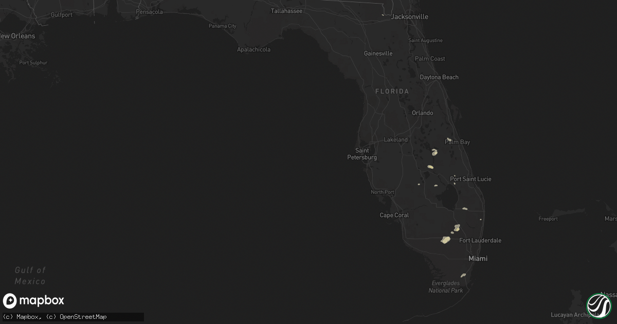
Hail Map in Florida on May 18, 2016
Get this storm
May 18 map
$229
one time, instant access
Download today. No call, no setup
Keep the $229
Bought the map and want the full workflow? Apply the entire $229 to a subscription within 7 days. None of it is wasted.
Every map, not just this one
This buys you this map. Subscription and you get every map we run, in the markets you choose from a few cities to whole states to nationwide. Plus real-time alerts the moment a storm fires.
Contact data
Name, contact info, occupancy, even credit band for addresses in the footprint. You go from where it hit to who to call.
Become the source they trust
Unlimited branding weather history reports on demand. You already have the documented answer ready for the property owner, and you are the one who showed up with it.
Property data and RoofTrace estimates
Pull up any address you have got, its value and the exact code rules for that jurisdiction, straight from One Click Code. Then RoofTrace estimates the squares, pitch, and roof value, priced the way you price.
Storm reports in Florida
Florida
| Date | Description |
|---|---|
| 05/18/20164:14 PM CDT | Broward county sheriff office reported damage to several homes near the intersection of nw 2nd way and nw 4th st. Damage included an awning being ripped off of a home a |
| 05/18/20163:24 PM CDT | Palm beach county fire rescue reported a powerline down near the intersection of cherry rd and seminole blvd. |
| 05/18/201612:50 PM CDT | An off-duty nws employee reported 3 medium sized trees down at the oasis shopping plaza near the intersection of campbell drive and sw 152nd avenue. |
All States Impacted by Hail Map on May 18, 2016
Cities Impacted by Hail Map on May 18, 2016
- Las Cruces, NM
- Marathon, TX
- Deming, NM
- Comstock, TX
- Ozona, TX
- Caballo, NM
- Zapata, TX
- Socorro, NM
- Mesilla, NM
- Mesilla Park, NM
- White Sands Missile Range, NM
- Asherton, TX
- Carrizo Springs, TX
- Dryden, TX
- Laredo, TX
- Guerra, TX
- Hebbronville, TX
- San Ygnacio, TX
- Enterprise, AL
- Fort Stockton, TX
- Encino, TX
- Linn, TX
- Sanderson, TX
- Rio Grande City, TX
- San Isidro, TX
- Santa Elena, TX
- Delmita, TX
- Columbus, NM
- Kenansville, FL
- Andalusia, AL
- Raymondville, TX
- San Perlita, TX
- Lorida, FL
- Sebring, FL
- Okeechobee, FL
- Venus, FL
- Lake Placid, FL
- Armstrong, TX
- Edinburg, TX
- Ochopee, FL
- Fort Rucker, AL
- New Brockton, AL
- Boynton Beach, FL
- Sonora, TX
- Slocomb, AL
- Levelland, TX
- Homestead, FL
- Quemado, NM
- Glen Saint Mary, FL
- Truth Or Consequences, NM
- Williamsburg, NM
- Eufaula, AL
- Dothan, AL
- Loxahatchee, FL
- Anton, TX
- Littlefield, TX
- Marfa, TX
- Alpine, TX
- Big Bend National Park, TX


