Hail Map in Billings, MT on May 18, 2014
The weather event in Billings, MT on May 18, 2014 includes Hail map. 7 states and 103 cities were impacted and suffered possible damage. The total estimated number of properties impacted is 43,586.
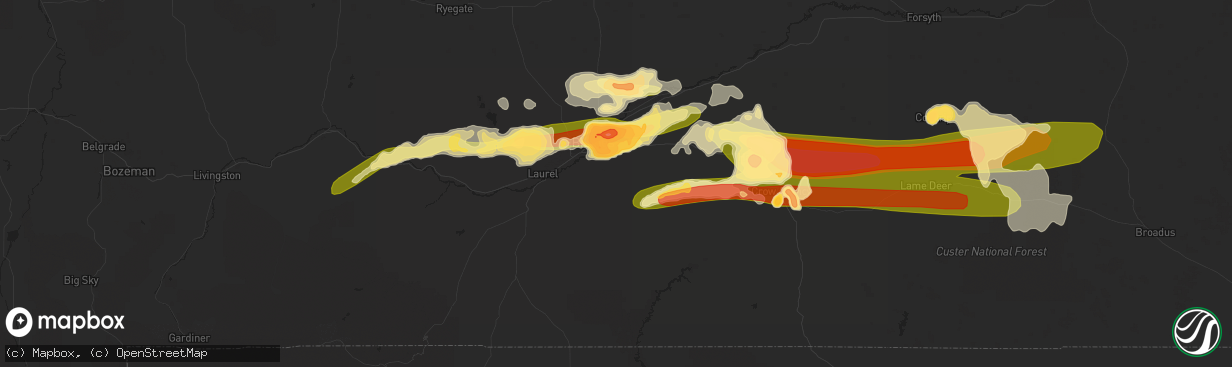
Hail
43,586
Estimated number of impacted properties by a 1.00" hail or larger47,207
Estimated number of impacted properties by a 1.75" hail or larger0
Estimated number of impacted properties by a 2.50" hail or largerStorm reports in Billings, MT
Billings, MT
| Date | Description |
|---|---|
| 05/18/20146:25 PM CDT | Broken basement window |
| 05/18/20146:20 PM CDT | A local report indicates 1.75 inch wind near 9 ESE LAUREL |
| 05/18/20146:19 PM CDT | A local report indicates 1.75 inch wind near 5 NE BILLINGS |
| 05/18/20146:17 PM CDT | A local report indicates 1.75 inch wind near 3 NNE BILLINGS |
| 05/18/20146:16 PM CDT | A local report indicates 60 MPH wind near 3 NW BILLINGS |
| 05/18/20146:16 PM CDT | A local report indicates 1.75 inch wind near 3 NW BILLINGS |
| 05/18/20146:15 PM CDT | A local report indicates 1.50 inch wind near 5 WNW BILLINGS |
| 05/18/20146:12 PM CDT | A local report indicates 1.25 inch wind near 5 NNE BILLINGS |
| 05/18/20146:12 PM CDT | A local report indicates 1.00 inch wind near 4 WNW BILLINGS |
| 05/18/20146:11 PM CDT | A local report indicates 2.75 inch wind near 4 NE BILLINGS |
| 05/18/20146:10 PM CDT | A local report indicates 1.75 inch wind near 2 N BILLINGS |
| 05/18/20146:09 PM CDT | A local report indicates 1.75 inch wind near 5 NE BILLINGS |
| 05/18/20146:09 PM CDT | Sustained winds of 52 mph with peak gusts to 59 mph. |
| 05/18/20146:09 PM CDT | A local report indicates 1.25 inch wind near 2 W BILLINGS |
| 05/18/20146:00 PM CDT | A local report indicates 1.00 inch wind near 2 W BILLINGS WEST END |
| 05/18/20145:55 PM CDT | A local report indicates 1.00 inch wind near 3 S BILLINGS WEST END |
All States Impacted by Hail Map on May 18, 2014
All Cities Impacted by Hail Map on May 18, 2014
- Park City, MT
- McLeod, MT
- Greycliff, MT
- Reed Point, MT
- Big Timber, MT
- Billings, MT
- Columbus, MT
- Laurel, MT
- Molt, MT
- Crow Agency, MT
- Huntley, MT
- Hardin, MT
- Cochran, GA
- Cadwell, GA
- Dexter, GA
- Chester, GA
- Eastman, GA
- Surrency, GA
- Jesup, GA
- Odum, GA
- Uvalda, GA
- Lumber City, GA
- Screven, GA
- Glenwood, GA
- Hazlehurst, GA
- Baxley, GA
- Broadus, MT
- Holloway, MN
- Ballantine, MT
- Alzada, MT
- Acton, MT
- Pompeys Pillar, MT
- Shepherd, MT
- Worden, MT
- Broadview, MT
- Alliance, NE
- Fullerton, ND
- Ortonville, MN
- Big Stone City, SD
- Pollock, SD
- Cody, NE
- Whitman, NE
- Valentine, NE
- Volborg, MT
- Elgin, ND
- Colstrip, MT
- Ainsworth, NE
- Forsyth, MT
- Correll, MN
- Fitzgerald, GA
- Abbeville, GA
- Roundup, MT
- Kulm, ND
- Newcastle, WY
- Otter, MT
- Danvers, MN
- Appleton, MN
- Odessa, MN
- Campbell, MN
- Fredonia, ND
- Twin Brooks, SD
- Corona, SD
- Milbank, SD
- Johnstown, NE
- Springview, NE
- Wilmot, SD
- Clinton, MN
- Lame Deer, MT
- Lehr, ND
- Morrill, NE
- Merriman, NE
- Ekalaka, MT
- Boyes, MT
- Elbow Lake, MN
- Garryowen, MT
- Mount Vernon, GA
- Alamo, GA
- Edgeley, ND
- Selfridge, ND
- Morristown, SD
- Watauga, SD
- Rapelje, MT
- Ryegate, MT
- Saint Xavier, MT
- Ellsworth, NE
- Tintah, MN
- Springdale, MT
- Dublin, GA
- Wishek, ND
- Absarokee, MT
- Ashland, MT
- Bloomfield, NE
- Bridger, MT
- Joliet, MT
- Rentz, GA
- Birney, MT
- Kadoka, SD
- Livingston, MT
- Morris, MN
- Toston, MT
- Hemingford, NE
- Musselshell, MT
- Busby, MT


