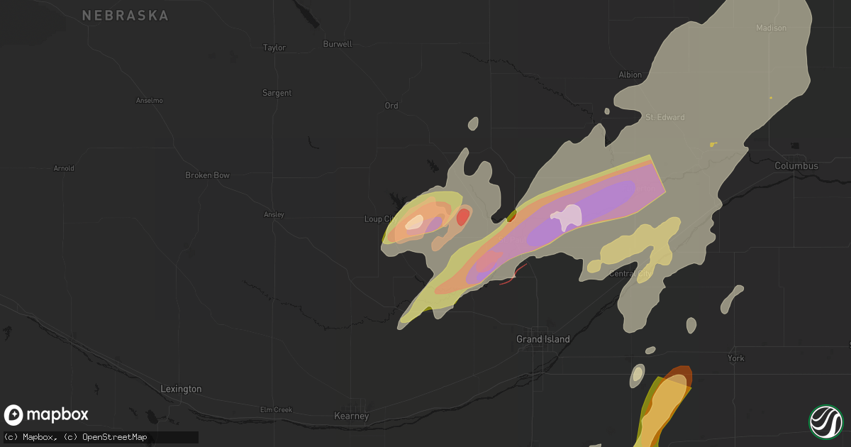
Hail Map in Ashton, NE on May 17, 2026
Get this storm
May 17 map
$229
one time, instant access
Download today. No call, no setup
Keep the $229
Bought the map and want the full workflow? Apply the entire $229 to a subscription within 7 days. None of it is wasted.
Every map, not just this one
This buys you this map. Subscription and you get every map we run, in the markets you choose from a few cities to whole states to nationwide. Plus real-time alerts the moment a storm fires.
Contact data
Name, contact info, occupancy, even credit band for addresses in the footprint. You go from where it hit to who to call.
Become the source they trust
Unlimited branding weather history reports on demand. You already have the documented answer ready for the property owner, and you are the one who showed up with it.
Property data and RoofTrace estimates
Pull up any address you have got, its value and the exact code rules for that jurisdiction, straight from One Click Code. Then RoofTrace estimates the squares, pitch, and roof value, priced the way you price.
Storm reports in Ashton, NE
Ashton, NE
| Date | Description |
|---|---|
| 05/17/20264:51 PM CDT | Danny near ashton. |
| 05/17/20264:50 PM CDT | A local report indicates 2.00 inch wind near 3 ENE Ashton |
| 05/17/20264:43 PM CDT | A local report indicates 3.00 inch wind near Ashton |
| 05/17/20264:35 PM CDT | A local report indicates 1.75 inch wind near 3.5 WSW Ashton |
| 05/17/20264:30 PM CDT | A local report indicates 2.50 inch wind near Ashton |
All States Impacted by Hail Map on May 17, 2026
All Cities Impacted by Hail Map on May 17, 2026
- Hollandale, WI
- Darlington, WI
- Blanchardville, WI
- Mineral Point, WI
- Mount Horeb, WI
- Barneveld, WI
- Valentine, NE
- Whitman, NE
- Madison, WI
- Verona, WI
- Middleton, WI
- Wood Lake, NE
- Johnstown, NE
- Springview, NE
- Sparks, NE
- Ainsworth, NE
- Winner, SD
- Colome, SD
- Mills, NE
- Dallas, SD
- Long Pine, NE
- Bassett, NE
- Gregory, SD
- Screven, GA
- Burke, SD
- Herrick, SD
- Stuart, NE
- Atkinson, NE
- Eden, WI
- Campbellsport, WI
- Newport, NE
- Lomira, WI
- Naples, FL
- Butte, NE
- Patterson, GA
- Glenbeulah, WI
- Plymouth, WI
- Saint Cloud, WI
- Cascade, WI
- Bristol, GA
- Naper, NE
- Saint Charles, SD
- Spencer, NE
- Oneill, NE
- Fairfax, SD
- Bristow, NE
- Axson, GA
- Pearson, GA
- Estero, FL
- Fort Myers, FL
- Odum, GA
- Platte, SD
- Lynch, NE
- Wagner, SD
- Lake Andes, SD
- Mayo, FL
- Nashville, GA
- Danville, GA
- Irwinton, GA
- Cleveland, WI
- Elkhart Lake, WI
- Nicholls, GA
- Cochran, GA
- Alapaha, GA
- Bonesteel, SD
- Geddes, SD
- Pickstown, SD
- Armour, SD
- Harrison, SD
- Corsica, SD
- Dante, SD
- Avon, SD
- Delmont, SD
- New Holland, SD
- Stickney, SD
- White Lake, SD
- Day, FL
- Franktown, CO
- Douglas, GA
- Ocilla, GA
- Niobrara, NE
- Willacoochee, GA
- Ocklawaha, FL
- McIntyre, GA
- Broxton, GA
- West Green, GA
- Gordon, GA
- Macon, GA
- Springfield, SD
- Elizabeth, CO
- Elbert, CO
- Weirsdale, FL
- Tampa, FL
- Blackshear, GA
- Cape Coral, FL
- Greenville, FL
- Kewaskum, WI
- Adell, WI
- Waldo, WI
- Sheboygan Falls, WI
- Sheboygan, WI
- Newton, WI
- Tripp, SD
- Tyndall, SD
- Scotland, SD
- Uvalda, GA
- Dublin, GA
- Covington, GA
- Rentz, GA
- Baxley, GA
- Immokalee, FL
- Denton, GA
- Haddock, GA
- Lesterville, SD
- Tabor, SD
- Parkston, SD
- Kaylor, SD
- Mount Vernon, SD
- Dimock, SD
- Menno, SD
- Olivet, SD
- Utica, SD
- Irene, SD
- Jonesboro, GA
- McAlpin, FL
- Lake City, FL
- Wellborn, FL
- Milledgeville, GA
- Gray, GA
- Saint Louis, MI
- Madison, FL
- Mount Vernon, GA
- O'Brien, FL
- Alachua, FL
- High Springs, FL
- Trenton, FL
- Atlanta, GA
- Riverdale, GA
- Shepherd, MI
- Viborg, SD
- Freeman, SD
- Hurley, SD
- Marion, SD
- Forest Park, GA
- Wray, GA
- Jacksonville, GA
- McRae Helena, GA
- Ailey, GA
- Fitzgerald, GA
- Stockton, GA
- Lehigh Acres, FL
- Hillsboro, GA
- Newberry, FL
- Breckenridge, MI
- Midland, MI
- Simla, CO
- Emery, SD
- Lake Park, GA
- Juliette, GA
- Mission Hill, SD
- Live Oak, FL
- Hazlehurst, GA
- Milan, GA
- Lake Butler, FL
- Monticello, FL
- Hemlock, MI
- Freeland, MI
- Volin, SD
- Parker, SD
- Bell, FL
- Lumber City, GA
- Du Pont, GA
- Labelle, FL
- Cody, NE
- Glenwood, GA
- Davis, SD
- Tea, SD
- Lennox, SD
- Chancellor, SD
- Sioux Falls, SD
- Harrisburg, SD
- Worthing, SD
- Ravenna, NE
- Bridgewater, SD
- Forsyth, GA
- Matheson, CO
- Limon, CO
- Chauncey, GA
- Eastman, GA
- Soperton, GA
- Rockledge, GA
- Tarrytown, GA
- Rhine, GA
- Brooker, FL
- Alamo, GA
- Monticello, GA
- Flovilla, GA
- Fort White, FL
- Branford, FL
- Saginaw, MI
- University Center, MI
- Bay City, MI
- Crofton, NE
- Lulu, FL
- Inglis, FL
- Bloomfield, NE
- Yankton, SD
- Loup City, NE
- Merrill, MI
- Hahira, GA
- Valdosta, GA
- Ray City, GA
- Boelus, NE
- Rockville, NE
- Cairo, NE
- Dannebrog, NE
- Fordyce, NE
- Gayville, SD
- Naylor, GA
- Genoa, CO
- Ashton, NE
- Essexville, MI
- Munger, MI
- Swainsboro, GA
- Twin City, GA
- Hugo, CO
- Vidalia, GA
- Lyons, GA
- Jenkinsburg, GA
- Locust Grove, GA
- Moody Afb, GA
- Jackson, GA
- Arriba, CO
- Adrian, GA
- Wakonda, SD
- Centerville, SD
- Jasper, FL
- Jennings, FL
- Lebanon, KS
- Esbon, KS
- Canton, SD
- Elba, NE
- Farwell, NE
- Greeley, NE
- Scotia, NE
- Saint Paul, NE
- Fairgrove, MI
- Unionville, MI
- Akron, MI
- Dexter, GA
- Dudley, GA
- Saint Helena, NE
- Vermillion, SD
- Hartford, SD
- East Dublin, GA
- Griffin, GA
- Brandon, SD
- Hawkinsville, GA
- Crystal River, FL
- Larchwood, IA
- Valley Springs, SD
- Beaver Creek, MN
- Hills, MN
- Luverne, MN
- Steen, MN
- Burr Oak, KS
- Beresford, SD
- Seibert, CO
- Flagler, CO
- Caro, MI
- Guide Rock, NE
- Red Cloud, NE
- Wolbach, NE
- Palmer, NE
- Chiefland, FL
- Alcester, SD
- Cordele, GA
- Belgrade, NE
- Vona, CO
- Gagetown, MI
- Inwood, IA
- Mankato, KS
- Sebewaing, MI
- Burbank, SD
- Superior, NE
- Lawrence, NE
- White Springs, FL
- Bunker Hill, KS
- Magnolia, MN
- Fairfield, NE
- Deweese, NE
- Nelson, NE
- Hunter, KS
- Sylvan Grove, KS
- Lucas, KS
- Bad Axe, MI
- Ubly, MI
- Cass City, MI
- Fullerton, NE
- Stratton, CO
- Dorrance, KS
- Archer, NE
- Kanaranzi, MN
- Kenneth, MN
- Rock Valley, IA
- Hudson, SD
- Owendale, MI
- Fairview, SD
- Wrightsville, GA
- Rock Rapids, IA
- Ellsworth, MN
- Cedar Rapids, NE
- Albion, NE
- Central City, NE
- Genoa, NE
- Inland, NE
- Harvard, NE
- Newman Grove, NE
- Bethune, CO
- Adrian, MN
- Edgar, NE
- Saint Edward, NE
- Ruskin, NE
- Russell, KS
- Lecanto, FL
- Homosassa, FL
- Lismore, MN
- Beloit, KS
- Clay Center, NE
- Sutton, NE
- Saronville, NE
- Chapman, NE
- Burlington, CO
- Saint Libory, NE
- Alvord, IA
- Wilmont, MN
- Crystal Springs, MS
- Perry, GA
- Hoisington, KS
- Hardy, NE
- Doon, IA
- Hull, IA
- Terry, MS
- Henderson, NE
- Aurora, NE
- Hampton, NE
- Rushmore, MN
- Minden City, MI
- Elko, GA
- Edgerton, MN
- Thonotosassa, FL
- Zephyrhills, FL
- Deshler, NE
- Webber, KS
- Courtland, KS
- Formoso, KS
- Glen Elder, KS
- Silver Creek, NE
- Lindsay, NE
- Republic, KS
- Byron, NE
- Belleville, KS
- Snover, MI
- Deckerville, MI
- Luray, KS
- Ruth, MI
- Harbor Beach, MI
- Blue Hill, NE
- Kanorado, KS
- Goodland, KS
- Weskan, KS
- Sharon Springs, KS
- Brewster, MN
- Worthington, MN
- Bradshaw, NE
- Monroe, NE
- Humphrey, NE
- Battle Creek, NE
- Madison, NE
- Marquette, NE
- Hordville, NE
- Clarks, NE
- Norfolk, NE
- Platte Center, NE
- Reading, MN
- Jewell, KS
- Westfield, IA
- Akron, IA
- Bigelow, MN
- Sibley, IA
- Giltner, NE
- Byram, MS
- Raymond, MS
- Plant City, FL
- Fulda, MN
- York, NE
- Davenport, NE
- Hebron, NE
- Carleton, NE
- Ashton, IA
- Wesley Chapel, FL
- Millwood, GA
- Little Rock, IA
- George, IA
- Randall, KS
- Hoskins, NE
- Elk Point, SD
- Round Lake, MN
- Okabena, MN
- Lakefield, MN
- Otis, KS
- Albert, KS
- Bison, KS
- Stanton, NE
- Strang, NE
- Le Mars, IA
- Ireton, IA
- Hawarden, IA
- Benedict, NE
- Stromsburg, NE
- Jackson, MS
- Oak, NE
- Belvidere, NE
- Bruning, NE
- Winside, NE
- Columbus, NE
- Polk, NE
- Osceola, NE
- Leigh, NE
- Creston, NE
- Wilson, KS
- Olmitz, KS
- Norway, KS
- Clarkson, NE
- Heron Lake, MN
- Dunnell, MN
- Pilger, NE
- Wayne, NE
- Chester, NE
- Sherburn, MN
- Trimont, MN
- Western, NE
- Bee, NE
- Seward, NE
- Lincoln, KS
- Ceylon, MN
- Wisner, NE
- Edson, KS
- Jackson, MN
- Saint James, MN
- Butterfield, MN
- Ohiowa, NE
- Alexandria, NE
- Odin, MN
- Wakefield, NE
- Emerson, NE
- Pender, NE
- Thurston, NE
- Sheldon, IA
- Valparaiso, NE
- Dwight, NE
- Maurice, IA
- Beemer, NE
- Welcome, MN
- Fairmont, MN
- Mahaska, KS
- Jackson, NE
- Hubbard, NE
- Dahlonega, GA
- Dorchester, NE
- Wilber, NE
- Crete, NE
- Barnard, KS
- Truman, MN
- Dodge, NE
- Howells, NE
- Ormsby, MN
- Pleasant Dale, NE
- Shelby, NE
- Duncan, NE
- Orange City, IA
- Shickley, NE
- Ong, NE
- Fairmont, NE
- Geneva, NE
- Milligan, NE
- Exeter, NE
- Friend, NE
- Cordova, NE
- McCool Junction, NE
- Beaver Crossing, NE
- Lincoln, NE
- Milford, NE
- Denton, NE
- Garland, NE
- Malcolm, NE
- Remsen, IA
- Alton, IA
- Gilead, NE
- Alpha, MN
- Haddam, KS
- Walthill, NE
- Sanborn, IA
- Rush Center, KS
- Larned, KS
- Waterbury, NE
- Endicott, NE
- Fairbury, NE
- Morrowville, KS
- Merrill, IA
- Bancroft, NE
- West Point, NE
- Dakota City, NE
- Windom, MN
- North Sioux City, SD
- Homer, NE
- South Sioux City, NE
- North Bend, NE
- Ceresco, NE
- Raymond, NE
- Davey, NE
- Brunsville, IA
- Prague, NE
- Weston, NE
- Malmo, NE
- Bellwood, NE
- Schuyler, NE
- Winnebago, NE
- Grand Island, NE
- Primrose, NE
- Levant, KS
- Brewster, KS
- Colby, KS
- Beverly, KS
- Minneapolis, KS
- Glasco, KS
- Rising City, NE
- David City, NE
- Mountain Lake, MN
- Winterville, GA
- Washington, KS
- Sioux City, IA
- Hanska, MN
- Simpson, KS
- Tobias, NE
- Granada, MN
- Blue Earth, MN
- Winnebago, MN
- Snyder, NE
- Scribner, NE
- Burdett, KS
- Rozel, KS
- Bingham Lake, MN
- Concordia, KS
- Hooper, NE
- Lewisville, MN
- Nekoma, KS
- Gresham, NE
- Daykin, NE
- Granville, IA
- Macy, NE
- Lyons, NE
- Fremont, NE
- Ithaca, NE
- Wahoo, NE
- Grafton, NE
- Waco, NE
- Salix, IA
- Swanton, NE
- Hallam, NE
- Lawton, IA
- Martell, NE
- Moville, IA
- Colbert, GA
- Rosalie, NE
- Hollenberg, KS
- Waverly, NE
- Yutan, NE
- Ashland, NE
- Mead, NE
- Oakland, NE
- Hinton, IA
- Bronson, IA
- Sergeant Bluff, IA
- Hospers, IA
- Delphos, KS
- Arlington, NE
- Craig, NE
- Herman, NE
- Nickerson, NE
- Sloan, IA
- Decatur, NE
- Walton, NE
- Greenwood, NE
- Murdock, NE
- Eagle, NE
- Louisville, NE
- Alvo, NE
- Elmwood, NE
- Sutherland, IA
- Royal, IA
- Peterson, IA
- Hartley, IA
- Springfield, NE
- Gretna, NE
- South Bend, NE
- Memphis, NE
- Waterloo, NE
- Archer, IA
- Rogers, NE
- Linwood, NE
- Ames, NE
- Morse Bluff, NE
- Cedar Bluffs, NE
- Valley, NE
- Elkhorn, NE
- Sprague, NE
- Roca, NE
- Hickman, NE
- Bennet, NE
- Clatonia, NE
- Omaha, NE
- Cedar Creek, NE
- Plattsmouth, NE
- Bellevue, NE
- Papillion, NE
- Uehling, NE
- Winslow, NE
- New Ulm, MN
- Gibbon, MN
- Madelia, MN
- Vernon Center, MN
- Oyens, IA
- Clyde, KS
- Tescott, KS
- Primghar, IA
- Amboy, MN
- Tekamah, NE
- Melvin, IA
- Diller, NE
- Steele City, NE
- Hanover, KS
- Byers, CO
- Whiting, IA
- Onawa, IA
- Kingsley, IA
- Climbing Hill, IA
- Hornick, IA
- Anthon, IA
- Pierson, IA
- Correctionville, IA
- Marcus, IA
- Colon, NE
- Palmyra, NE
- Cleghorn, IA
- Modale, IA
- Washta, IA
- Moorhead, IA
- Little Sioux, IA
- Mapleton, IA
- Soldier, IA
- Smithland, IA
- Bennington, NE
- Oto, IA
- Crescent, IA
- Kennard, NE
- La Vista, NE
- Pisgah, IA
- Blencoe, IA
- Boys Town, NE
- Blair, NE
- Fort Calhoun, NE
- Rodney, IA
- Castana, IA
- Washington, NE
- Mondamin, IA
- Missouri Valley, IA
- Meriden, IA
- Weeping Water, NE
- Manley, NE
- De Witt, NE
- Offutt Afb, NE
- Silver City, IA
- Carter Lake, IA
- Ute, IA
- McClelland, IA
- Council Bluffs, IA
- Logan, IA
- Danbury, IA
- Honey Creek, IA
- Pacific Junction, IA
- Underwood, IA
- Mineola, IA
- Glenwood, IA
- Woodbine, IA
- Neola, IA
- Magnolia, IA
- Dunlap, IA
- Miltonvale, KS
- Paullina, IA
- Lake Crystal, MN
- Adams, NE
- Cortland, NE
- Firth, NE
- Panama, NE
- Lafayette, MN
- Unadilla, NE
- Douglas, NE
- Winthrop, MN
- Calumet, IA
- Quimby, IA
- Murray, NE
- Nehawka, NE
- Syracuse, NE
- Avoca, NE
- Otoe, NE
- Holstein, IA
- Larrabee, IA
- Ricketts, IA
- Dow City, IA
- Ida Grove, IA
- Battle Creek, IA
- Persia, IA
- Portsmouth, IA
- Cherokee, IA
- Schleswig, IA
- Cushing, IA
- Treynor, IA
- Charter Oak, IA
- Aurelia, IA
- Galva, IA
- Denison, IA
- Everly, IA
- Pickrell, NE
- Bennington, KS
- Aurora, KS
- Linn, KS
- Agenda, KS
- Clifton, KS
- Palmer, KS
- Clay Center, KS
- Morganville, KS
- Mapleton, MN
- Longford, KS
- Wakefield, KS
- Solomon, KS
- Abilene, KS
- Thurman, IA
- Sterling, NE
- Cook, NE
- Tecumseh, NE
- Burr, NE
- Talmage, NE
- Lorton, NE
- Nebraska City, NE
- Union, NE
- Dunbar, NE
- Odell, NE
- Alta, IA
- Storm Lake, IA
- Sioux Rapids, IA
- Arnolds Park, IA
- Shelby, IA
- Odebolt, IA
- Minden, IA
- Fostoria, IA
- Schaller, IA
- Greenville, IA
- Arion, IA
- Spencer, IA
- Linn Grove, IA
- Arthur, IA
- Rembrandt, IA
- Kiron, IA
- Earling, IA
- Milford, IA
- Panama, IA
- Spirit Lake, IA
- Okoboji, IA
- Ocheyedan, IA
- Greenleaf, KS
- Green, KS
- Barnes, KS
- Wymore, NE
- Bremen, KS
- Alexander, KS
- Garden City, MN
- Delavan, MN
- Lake Park, IA
- Harris, IA
- Percival, IA
- Manilla, IA
- Harlan, IA
- Emerson, IA
- Tabor, IA
- Oakland, IA
- Malvern, IA
- Early, IA
- Farragut, IA
- Defiance, IA
- Johnson, NE
- Macedonia, IA
- Deloit, IA
- Hamburg, IA
- Westphalia, IA
- Avoca, IA
- Truesdale, IA
- Hastings, IA
- Randolph, IA
- Hancock, IA
- Henderson, IA
- Brock, NE
- Carson, IA
- Sidney, IA
- Imogene, IA
- Albert City, IA
- Marathon, IA
- Good Thunder, MN
- Filley, NE
- Beatrice, NE
- Blue Springs, NE
- Virginia, NE
- Crab Orchard, NE
- Dickens, IA
- Gillett Grove, IA
- Vail, IA
- Nemaha, IA
- Webb, IA
- Irwin, IA
- Wall Lake, IA
- Superior, IA
- Estherville, IA
- Terril, IA
- Kirkman, IA
- Pocahontas, IA
- Laurens, IA
- Havelock, IA
- Pomeroy, IA
- Peru, NE
- Riverton, IA
- Julian, NE
- Auburn, NE
- Rock Port, MO
- Garretson, SD
- Boyden, IA
- Liberty, NE
- Burchard, NE
- Lewiston, NE
- Ness City, KS
- Lester, IA
- La Crosse, KS
- Claflin, KS
- Ruthven, IA
- Mankato, MN
- Randolph, KS
- Marysville, KS
- Oketo, KS
- Waterville, KS
- Barneston, NE
- Riley, KS
- Leonardville, KS
- Blue Rapids, KS
- Lake View, IA
- Newell, IA
- Armstrong, IA
- Ellsworth, KS
- Emmetsburg, IA
- Graettinger, IA
- Rockwell City, IA
- Taopi, MN
- Le Roy, MN
- Ayrshire, IA
- Jetmore, KS
- Home, KS
- Elk Creek, NE
- Pawnee City, NE
- Beattie, KS
- Frankfort, KS
- Milford, KS
- Summerfield, KS
- Steinauer, NE
- Manhattan, KS
- Junction City, KS
- Fort Riley, KS
- Chapman, KS
- Olsburg, KS
- Watson, MO
- Red Oak, IA
- Breda, IA
- Kimballton, IA
- Manning, IA
- Walnut, IA
- Elliott, IA
- Shenandoah, IA
- Lewis, IA
- Marne, IA
- Essex, IA
- Elk Horn, IA
- Atlantic, IA
- Sac City, IA
- Aspinwall, IA
- Audubon, IA
- Arcadia, IA
- Coin, IA
- Westside, IA
- Griswold, IA
- Auburn, IA
- Templeton, IA
- Mallard, IA
- Exira, IA
- Stanton, IA
- Carroll, IA
- Varina, IA
- Clarinda, IA
- Ringsted, IA
- Halbur, IA
- Gray, IA
- Wallingford, IA
- Dolliver, IA
- Jolley, IA
- Curlew, IA
- Lytton, IA
- Brayton, IA
- Fonda, IA
- Lake City, IA
- Cylinder, IA
- Clare, IA
- Swea City, IA
- Glidden, IA
- Villisca, IA
- Elmore, MN
- Lakota, IA
- Scranton, IA
- Algona, IA
- Fort Dodge, IA
- Lone Rock, IA
- Ottosen, IA
- Corwith, IA
- Barnum, IA
- Anita, IA
- Manson, IA
- Churdan, IA
- Dedham, IA
- Lidderdale, IA
- Wiota, IA
- Humboldt, IA
- Grant, IA
- Buffalo Center, IA
- Wesley, IA
- Rutland, IA
- Ralston, IA
- Moorland, IA
- Dakota City, IA
- Bancroft, IA
- Knierim, IA
- West Bend, IA
- Gowrie, IA
- Titonka, IA
- Hardy, IA
- Plover, IA
- Fenton, IA
- Burt, IA
- Badger, IA
- Bradgate, IA
- Guthrie Center, IA
- Forest City, IA
- Lanesboro, IA
- Woden, IA
- Britt, IA
- Whittemore, IA
- Coon Rapids, IA
- Callender, IA
- Lohrville, IA
- Ledyard, IA
- Jefferson, IA
- Gilmore City, IA
- Bayard, IA
- Farnhamville, IA
- Somers, IA
- Lu Verne, IA
- Palmer, IA
- Cumberland, IA
- Renwick, IA
- Rolfe, IA
- Bode, IA
- Hamlin, IA
- Adair, IA
- Livermore, IA
- Elkton, MN
- Lindon, CO
- Cimarron, KS
- Westmoreland, KS
- Vermillion, KS
- Baileyville, KS
- Axtell, KS
- Humboldt, NE
- Table Rock, NE
- Du Bois, NE
- Seneca, KS
- Saint George, KS
- Wamego, KS
- Ogden, KS
- Centralia, KS
- Onaga, KS
- Bern, KS
- Salina, KS
- New Cambria, KS
- Talmage, KS
- Alma, KS
- Corning, KS
- Nodaway, IA
- New Market, IA
- Corning, IA
- Carbon, IA
- Casey, IA
- Massena, IA
- Gravity, IA
- Dana, IA
- Fontanelle, IA
- Goldfield, IA
- Paton, IA
- Yorktown, IA
- Thor, IA
- Bridgewater, IA
- Panora, IA
- Bagley, IA
- Otho, IA
- Bedford, IA
- Prescott, IA
- Yale, IA
- Vincent, IA
- Glenville, MN
- Ogden, IA
- Dayton, IA
- Rippey, IA
- Goodell, IA
- Crystal Lake, IA
- Burnside, IA
- Webster City, IA
- Wells, MN
- Harcourt, IA
- Lehigh, IA
- Conger, MN
- Northwood, IA
- Emmons, MN
- Klemme, IA
- Garner, IA
- Lake Mills, IA
- Fertile, IA
- Thompson, IA
- Dawson, IA
- Clear Lake, IA
- Eagle Grove, IA
- Duncombe, IA
- Orient, IA
- Frost, MN
- Alden, MN
- Ventura, IA
- Scarville, IA
- Kanawha, IA
- Joice, IA
- Bricelyn, MN
- Woolstock, IA
- Jamaica, IA
- Clarion, IA
- Pilot Mound, IA
- Twin Lakes, MN
- Belmond, IA
- Grand Junction, IA
- Hayward, MN
- Kiester, MN
- Greenfield, IA
- Leland, IA
- Albert Lea, MN
- Beaver, IA
- Rake, IA
- Boxholm, IA
- Stuart, IA
- Menlo, IA
- Brownville, NE
- Mason City, IA
- Spring Valley, MN
- Greenwood, WI
- Neillsville, WI
- New Richland, MN
- Freeborn, MN
- Hartland, MN
- Easton, MN
- Minnesota Lake, MN
- Waldorf, MN
- Ellendale, MN
- Owatonna, MN
- Waseca, MN
- Fairfax, MO
- Goff, KS
- Hanston, KS
- Clarks Grove, MN
- Morrill, KS
- Falls City, NE
- Shubert, NE
- Salem, NE
- Sabetha, KS
- Havensville, KS
- Belvue, KS
- Verdon, NE
- Nemaha, NE
- Tarkio, MO
- Oneida, KS
- Stella, NE
- Dawson, NE
- Westboro, MO
- Northboro, IA
- McFarland, KS
- Circleville, KS
- Saint Marys, KS
- Hiawatha, KS
- Paxico, KS
- Soldier, KS
- Delia, KS
- Holton, KS
- Maple Hill, KS
- Fairview, KS
- Wetmore, KS
- Emmett, KS
- Powhattan, KS
- Netawaka, KS
- Janesville, MN
- Holyrood, KS
- Loyal, WI
- Blooming Prairie, MN
- Kenyon, MN
- Medford, MN
- Geneva, MN
- Hope, MN
- West Concord, MN
- Claremont, MN
- Faribault, MN
- Hollandale, MN
- Wanamingo, MN
- Thornton, IA
- Dodge Center, MN
- Kensett, IA
- Perry, IA
- Stratford, IA
- Linden, IA
- Manly, IA
- Boone, IA
- Hanlontown, IA
- Pine Island, MN
- Hayfield, MN
- Zumbrota, MN
- Austin, MN
- Creston, IA
- Minburn, IA
- Galt, IA
- Kamrar, IA
- Blairsburg, IA
- Cromwell, IA
- Meservey, IA
- Stanhope, IA
- Woodward, IA
- Rowan, IA
- Clearfield, IA
- Redfield, IA
- Sharpsburg, IA
- Lenox, IA
- Adel, IA
- Bouton, IA
- Dexter, IA
- Alexander, IA
- Dows, IA
- Dexter, MN
- Grand Meadow, MN
- Lorraine, KS
- Craig, MO
- Mayetta, KS
- Hoyt, KS
- Horton, KS
- Rossville, KS
- Topeka, KS
- Silver Lake, KS
- Whiting, KS
- Rulo, NE
- Valley Falls, KS
- Denison, KS
- Meriden, KS
- White Cloud, KS
- Muscotah, KS
- Pickering, MO
- Maryville, MO
- Fillmore, MO
- Highland, KS
- Braddyville, IA
- Burlington Junction, MO
- Everest, KS
- Skidmore, MO
- Mound City, MO
- Maitland, MO
- Bolckow, MO
- Hopkins, MO
- Clearmont, MO
- Barnard, MO
- Oregon, MO
- Elmo, MO
- Robinson, KS
- Troy, KS
- Blanchard, IA
- Denton, KS
- Lancaster, KS
- Effingham, KS
- Forest City, MO
- Graham, MO
- Sheridan, MO
- College Springs, IA
- Shambaugh, IA
- Gentry, MO
- Denver, MO
- Albany, MO
- Savannah, MO
- Conception Junction, MO
- Nortonville, KS
- Worth, MO
- Conception, MO
- Stanberry, MO
- Atchison, KS
- Ravenwood, MO
- Grant City, MO
- Blockton, IA
- Guilford, MO
- Amazonia, MO
- King City, MO
- Clyde, MO
- Parnell, MO
- Rosendale, MO
- Rea, MO
- Bendena, KS
- Wathena, KS
- Kellerton, IA
- Saint Charles, IA
- Lyle, MN
- Polk City, IA
- Dallas Center, IA
- West Des Moines, IA
- Grimes, IA
- Popejoy, IA
- Alden, IA
- Madrid, IA
- Benton, IA
- Earlham, IA
- Van Meter, IA
- De Soto, IA
- Randall, IA
- Swaledale, IA
- Ellsworth, IA
- Slater, IA
- Cumming, IA
- Radcliffe, IA
- Winterset, IA
- Grafton, IA
- Mount Ayr, IA
- Story City, IA
- Booneville, IA
- Jewell, IA
- Murray, IA
- Coulter, IA
- Waltham, MN
- Rockwell, IA
- Johnston, IA
- Clive, IA
- Gilbert, IA
- Saint Ansgar, IA
- Thayer, IA
- Urbandale, IA
- Macksburg, IA
- Sheffield, IA
- Tingley, IA
- Hatfield, MO
- Ames, IA
- Luther, IA
- Latimer, IA
- Diagonal, IA
- Granger, IA
- Lansing, MN
- Hampton, IA
- Redding, IA
- Waukee, IA
- Kelley, IA
- Lorimor, IA
- Williams, IA
- Peru, IA
- Shannon City, IA
- Ellston, IA
- Afton, IA
- Black River Falls, WI
- Pawnee Rock, KS
- Kanopolis, KS
- Hixton, WI
- Union Star, MO
- Rushville, MO
- Helena, MO
- Elwood, KS
- Darlington, MO
- Saint Joseph, MO
- Cosby, MO
- Cummings, KS
- Alma Center, WI
- Merrillan, WI
- Melrose, WI
- Melbourne, IA
- Elkhart, IA
- Truro, IA
- Rockford, IA
- New Providence, IA
- Allison, IA
- Martensdale, IA
- Bradford, IA
- Saint Anthony, IA
- Mantorville, MN
- Hubbard, IA
- Des Moines, IA
- Wellsburg, IA
- Mitchellville, IA
- Grand River, IA
- Rock Falls, IA
- Nora Springs, IA
- Cambridge, IA
- Nevada, IA
- Garden City, IA
- Berwick, IA
- Marble Rock, IA
- Indianola, IA
- Alleman, IA
- Sargeant, MN
- Carpenter, IA
- Osceola, IA
- Huxley, IA
- Aredale, IA
- State Center, IA
- Mingo, IA
- Iowa Falls, IA
- Saint Marys, IA
- Chapin, IA
- Runnells, IA
- Zearing, IA
- Clemons, IA
- Baxter, IA
- Colfax, IA
- Brownsdale, MN
- Altoona, IA
- Marshalltown, IA
- Rose Creek, MN
- Collins, IA
- Bevington, IA
- Rudd, IA
- Steamboat Rock, IA
- Grundy Center, IA
- New Virginia, IA
- Sheldahl, IA
- Ackley, IA
- Dumont, IA
- Prole, IA
- Whitten, IA
- Kasson, MN
- McCallsburg, IA
- Patterson, IA
- Osage, IA
- Conrad, IA
- Bondurant, IA
- Albion, IA
- Greene, IA
- Carlisle, IA
- Roland, IA
- Austinville, IA
- Eldora, IA
- Plymouth, IA
- Windsor Heights, IA
- Union, IA
- Pleasant Hill, IA
- Norwalk, IA
- Geneva, IA
- Colo, IA
- Liscomb, IA
- Dougherty, IA
- Bristow, IA
- Rhodes, IA
- Ankeny, IA
- Aplington, IA
- Maxwell, IA
- Humbird, WI
- Hartford, IA
- Ira, IA
- Van Wert, IA
- Lamoni, IA
- Ackworth, IA
- Great Bend, KS
- Brookville, KS
- Augusta, WI
- Turtle Lake, WI
- Stewartville, MN
- Kesley, IA
- Adams, MN
- Little Cedar, IA
- Byron, MN
- Orchard, IA
- Stacyville, IA
- Floyd, IA
- Charles City, IA
- Riceville, IA
- Eyota, MN
- Mazeppa, MN
- Clarksville, IA
- Racine, MN
- Zumbro Falls, MN
- McIntire, IA
- Chester, IA
- Oronoco, MN
- Elgin, MN
- Ostrander, MN
- Rochester, MN
- Parkersburg, IA
- Elma, IA
- Colwell, IA
- Alta Vista, IA
- Wykoff, MN
- Lime Springs, IA
- Holland, IA
- Nashua, IA
- Shell Rock, IA
- Harmony, MN
- Preston, MN
- Chatfield, MN
- Ionia, IA
- New Hartford, IA
- Plainfield, IA
- New Hampton, IA
- Newton, IA
- Dike, IA
- Waverly, IA
- Prairie City, IA
- Stout, IA
- Beaman, IA
- Milo, IA
- Laurel, IA
- Swan, IA
- Haverhill, IA
- Lucas, IA
- Woodburn, IA
- Pleasantville, IA
- Monroe, IA
- Gladbrook, IA
- Reinbeck, IA
- Cedar Falls, IA
- Cresco, IA
- Enterprise, KS
- Medford, WI
- Stetsonville, WI
- Hope, KS
- Athens, WI
- Rib Lake, WI
- Geneseo, KS
- Harshaw, WI
- Rhinelander, WI
- Bushton, KS
- Meeker, CO
- Agate, CO
- Three Lakes, WI
- Eagle River, WI
- Argonne, WI
- Davenport, IA
- Rock Island, IL
- Milan, IL
- Crystal Falls, MI
- Tipton, KS
- Michigamme, MI
- Eldridge, IA
- Bettendorf, IA
- Amasa, MI
- Republic, MI
- Champion, MI
- Camanche, IA
- Princeton, IA
- East Moline, IL
- Pleasant Valley, IA
- Moline, IL
- Hampton, IL
- Clinton, IA
- Le Claire, IA
- Taylor Ridge, IL
- Channing, MI
- Reynolds, IL
- Coal Valley, IL
- Sagola, MI
- Long Grove, IA
- Mount Carroll, IL
- Savanna, IL
- Geneseo, IL
- Colona, IL
- Felch, MI
- Blue Grass, IA
- McCausland, IA
- Andalusia, IL
- Oquawka, IL
- Sherrard, IL
- Aledo, IL
- Erie, IL
- Hillsdale, IL
- Orion, IL
- Darien, WI
- Delavan, WI
- Sharon, WI
- Elkhorn, WI
- Tiskilwa, IL
- Princeton, IL
- Montrose, GA
- Cordova, IL
- Gibbs, MO
- Brashear, MO
- Kirksville, MO
- Hurdland, MO
- La Plata, MO
- Chilton, WI
- Malone, WI
- Mount Calvary, WI
- Fond Du Lac, WI
- Kiel, WI
- Valders, WI
- New Holstein, WI
- Onekama, MI
- Bear Lake, MI
- Lynd, MN
- Tyler, MN
- Russell, MN
- Balaton, MN
- Ruthton, MN
- Wallace, KS
- Winona, KS


