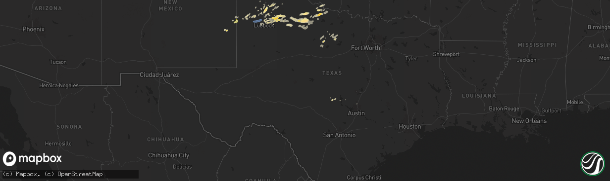
Hail Map in Texas on May 15, 2024
The weather event in Texas on May 15, 2024 includes Hail and Wind maps. 10 states and 385 cities were impacted and suffered possible damage. The total estimated number of properties impacted is 11,940.
Want more than just the map?
Turn this storm into a full workflow.
- Owner + property data so you know who to knock
- OnDemand branded weather history reports to win the "did we even have hail?" argument
- RoofTrace estimate so reps stop guessing numbers at the door
Bought this map? Upgrade within 7 days and we'll credit the $230. (10-15 min setup call)
Hail
Wind
11,940
Estimated number of impacted properties by a 1.00" hail or larger270
Estimated number of impacted properties by a 1.75" hail or larger0
Estimated number of impacted properties by a 2.50" hail or largerStorm reports in Texas
Texas
| Date | Description |
|---|---|
| 05/15/20246:51 PM CDT | A local report indicates 1.00 inch wind near 3 N Stinnett |
| 05/15/20246:35 PM CDT | A local report indicates 1.00 inch wind near Sunray |
| 05/15/20246:32 PM CDT | Time estimated on radar. |
| 05/15/20246:27 PM CDT | A local report indicates 1.00 inch wind near Sunray |
| 05/15/20246:21 PM CDT | A local report indicates 79 MPH wind near 9 NNE Sunray |
| 05/15/20246:20 PM CDT | A local report indicates 71 MPH wind near 9 NNE Sunray |
| 05/15/20246:12 PM CDT | A local report indicates 70 MPH wind near 3 SE Dumas |
| 05/15/20245:58 PM CDT | Multiple photos submitted to local media of various tree damage. Three inch diameter tree limb snapped. Couple of dead or diseased trees uprooted. One of witch fell on |
| 05/15/20245:11 PM CDT | A local report indicates 1.25 inch wind near 5 N Dalhart |
| 05/15/20245:10 PM CDT | A local report indicates 69 MPH wind near 3 SW Dalhart |
| 05/15/20244:32 PM CDT | Measured by the west texas mesonet. Corrected from non-tstm gust. |
| 05/15/20244:30 PM CDT | Quarter to golf ball size. Time estimated. |
| 05/15/20244:15 PM CDT | A local report indicates 1.00 inch wind near 7 E Texline |
| 05/15/20243:54 PM CDT | Public report... Time estimated on radar. |
| 05/15/20245:26 AM CDT | Tree damage in bomarton... Tx. Twitter report with picture. Time estimated from radar. |
| 05/15/20245:18 AM CDT | Mesonet station 73 weinert 2 nne. |
| 05/15/20245:10 AM CDT | A local report indicates 60 MPH wind near 3 NW Knox City |
| 05/15/20245:05 AM CDT | A local report indicates 60 MPH wind near 3 NW Knox City |
| 05/15/20245:00 AM CDT | A local report indicates 60 MPH wind near 3 NW Knox City |
| 05/15/20243:41 AM CDT | Report from mping: golf ball |
| 05/15/20243:38 AM CDT | Report from mping: ping pong ball |
| 05/15/20243:00 AM CDT | A local report indicates 67 MPH wind near 3 NNW Mcadoo |
| 05/15/20241:26 AM CDT | A local report indicates 58 MPH wind near 4 NNE Shallowater |
| 05/15/20241:25 AM CDT | Time estimated from radar. |
| 05/15/20241:00 AM CDT | A local report indicates 58 MPH wind near 6 SSW Anton |
| 05/14/20248:33 PM CDT | Occurred from outflow 15 miles ahead of thunderstorms. Measured by the west texas mesonet. |
| 05/14/20248:33 PM CDT | Occurred from outflow 15 miles ahe |
| 05/14/20247:38 PM CDT | Also gusted to 61 mph at 737 pm. Measured by the west texas mesonet. |
| 05/14/20247:31 PM CDT | Measured by west texas mesonet. |
| 05/14/20247:14 PM CDT | Also gusted to 60 mph at 715 pm. Measured by the west texas mesonet. |
| 05/14/20247:03 PM CDT | Report from mping: quarter |
All States Impacted by Hail Map on May 15, 2024
Cities Impacted by Hail Map on May 15, 2024
- Lake Alfred, FL
- Auburndale, FL
- Winter Haven, FL
- Lake Wales, FL
- Old Town, FL
- Chiefland, FL
- Kenansville, FL
- Wauchula, FL
- Zolfo Springs, FL
- Palm Bay, FL
- Avon Park, FL
- Fellsmere, FL
- Sebastian, FL
- Grant, FL
- Melbourne Beach, FL
- Okeechobee, FL
- Lorida, FL
- Vero Beach, FL
- Fort Pierce, FL
- Conway, SC
- West Palm Beach, FL
- Longs, SC
- North Myrtle Beach, SC
- Lake Placid, FL
- Davis, NC
- Chelsea, OK
- Stacy, NC
- Vinita, OK
- Lenoir, NC
- Hudson, NC
- Granite Falls, NC
- Geneva, FL
- Mims, FL
- Malabar, FL
- Gaffney, SC
- Connelly Springs, NC
- Hickory, NC
- Sunset, SC
- Blacksburg, SC
- Smyrna, SC
- Hickory Grove, SC
- Newton, NC
- Ellerbe, NC
- Mount Gilead, NC
- Grenville, NM
- Spartanburg, SC
- Candor, NC
- York, SC
- Pickens, SC
- North Augusta, SC
- Trenton, SC
- Edgefield, SC
- Easley, SC
- Clayton, NM
- Tulia, TX
- Whiteville, NC
- Fort Mill, SC
- Rock Hill, SC
- Myrtle Beach, SC
- Little River, SC
- Texline, TX
- Burgaw, NC
- Hallsboro, NC
- Alcolu, SC
- Manning, SC
- Waxhaw, NC
- Peyton, CO
- Lockney, TX
- Waterloo, NE
- Valley, NE
- Lake Waccamaw, NC
- Aiken, SC
- Kennard, NE
- Arlington, NE
- Bennington, NE
- Bolton, NC
- Monroe, NC
- Marshville, NC
- Peachland, NC
- Lancaster, SC
- Calhan, CO
- Enochs, TX
- Amherst, TX
- New Zion, SC
- Colorado Springs, CO
- Kingstree, SC
- Elkhorn, NE
- Omaha, NE
- Salemburg, NC
- Hale Center, TX
- Rocky Point, NC
- Lakeview, TX
- Plainview, TX
- Delco, NC
- Polkton, NC
- Clarendon, TX
- Yoder, CO
- Maple Hill, NC
- Cades, SC
- Lake City, SC
- Fort Calhoun, NE
- Dalhart, TX
- Roseboro, NC
- Boone, CO
- Maple, TX
- Clinton, NC
- Leland, NC
- Lelia Lake, TX
- Hedley, TX
- Crescent, IA
- Lamar, SC
- Tatum, NM
- Scranton, SC
- Ash, NC
- Littlefield, TX
- Hubert, NC
- Honey Creek, IA
- Rye, CO
- Milnesand, NM
- Wallace, NC
- Richlands, NC
- Colorado City, CO
- Camp Lejeune, NC
- Andrews, SC
- Kress, TX
- Morton, TX
- Causey, NM
- Olton, TX
- Swansboro, NC
- Quitaque, TX
- Willard, NC
- Jacksonville, NC
- Georgetown, SC
- Coward, SC
- Stella, NC
- Hartley, TX
- Stratford, TX
- Silverton, TX
- Kim, CO
- Ordway, CO
- Olney Springs, CO
- Newport, NC
- Pep, TX
- Maysville, NC
- Winnabow, NC
- Wilmington, NC
- Dumas, TX
- Manzanola, CO
- Maiden, NC
- Cactus, TX
- Bladenboro, NC
- Lumberton, NC
- Pawleys Island, SC
- Bluff City, KS
- Clarkton, NC
- Elizabethtown, NC
- Caldwell, KS
- Harrells, NC
- Pritchett, CO
- Milan, KS
- Freeport, KS
- Sunray, TX
- Garland, NC
- Mayfield, KS
- Council, NC
- Wellington, KS
- Argonia, KS
- Las Animas, CO
- Ivanhoe, NC
- Walsenburg, CO
- Belle Plaine, KS
- Medford, OK
- Canadian, TX
- South Haven, KS
- Chadbourn, NC
- Stinnett, TX
- Morse, TX
- Spearman, TX
- Gruver, TX
- Skellytown, TX
- Miami, TX
- Arnett, OK
- Braman, OK
- Follett, TX
- Shattuck, OK
- Peck, KS
- Newkirk, OK
- Udall, KS
- Geuda Springs, KS
- Douglass, KS
- Deer Creek, OK
- Mulvane, KS
- Nardin, OK
- Blackwell, OK
- Atkinson, NC
- Hereford, TX
- Booker, TX
- Kelly, NC
- Riegelwood, NC
- Fritch, TX
- Borger, TX
- Arkansas City, KS
- Maple City, KS
- Kaw City, OK
- Ponca City, OK
- Rose Hill, KS
- Rock, KS
- Derby, KS
- Atlanta, KS
- Fargo, OK
- Currie, NC
- Augusta, KS
- Leon, KS
- Pampa, TX
- Perryton, TX
- Oxford, KS
- Rosalia, KS
- El Dorado, KS
- Latham, KS
- Gage, OK
- Woodward, OK
- Shidler, OK
- May, OK
- Laverne, OK
- Eureka, KS
- Fort Supply, OK
- Burbank, OK
- Fairfax, OK
- Sedan, KS
- Piedmont, KS
- Severy, KS
- Buffalo, OK
- Mooreland, OK
- Pawhuska, OK
- Freedom, OK
- Fall River, KS
- Toronto, KS
- Fredonia, KS
- Alva, OK
- Murrells Inlet, SC
- Dacoma, OK
- Wynona, OK
- Yates Center, KS
- Buffalo, KS
- Barnsdall, OK
- Bartlesville, OK
- Rosston, OK
- Kiowa, KS
- Hardtner, KS
- Skiatook, OK
- Great Bend, KS
- Ochelata, OK
- Ramona, OK
- Llano, TX
- Valley Spring, TX
- Marland, OK
- Shallowater, TX
- Lubbock, TX
- Ashland, KS
- Talala, OK
- Collinsville, OK
- Vera, OK
- Lorenzo, TX
- Nowata, OK
- Danville, KS
- Minneola, KS
- Anthony, KS
- Mullinville, KS
- St John, KS
- Medicine Lodge, KS
- Sharon, KS
- Cunningham, KS
- Nashville, KS
- Isabel, KS
- Harper, KS
- Spivey, KS
- Zenda, KS
- Attica, KS
- Kingman, KS
- Idalou, TX
- Winfield, KS
- Oologah, OK
- Stafford, KS
- Conway Springs, KS
- Raymond, KS
- Murdock, KS
- Pretty Prairie, KS
- Norwich, KS
- Burden, KS
- Pond Creek, OK
- Chase, KS
- Cambridge, KS
- Burnet, TX
- Bluejacket, OK
- Clearwater, KS
- Welch, OK
- Buchanan Dam, TX
- Cheney, KS
- Milton, KS
- Cedar Vale, KS
- Dexter, KS
- Nash, OK
- Ralls, TX
- Mount Hope, KS
- Wichita, KS
- Manhattan, KS
- Peru, KS
- Georgetown, TX
- Fairland, OK
- Wyandotte, OK
- Crosbyton, TX
- Sedgwick, KS
- Valley Center, KS
- Colwich, KS
- Abernathy, TX
- Mcadoo, TX
- Okarche, OK
- El Reno, OK
- Kingfisher, OK
- Piedmont, OK
- Yukon, OK
- Guthrie, OK
- Cashion, OK
- Edmond, OK
- Oklahoma City, OK
- Dickens, TX
- Longton, KS
- Elk Falls, KS
- Afton, TX
- Elk City, KS
- Moline, KS
- Grenola, KS
- Neodesha, KS
- Cherryvale, KS
- Thayer, KS
- Independence, KS
- Levelland, TX
- Anton, TX
- Floydada, TX
- Dennis, KS
- Mound Valley, KS
- Parsons, KS
- McCune, KS
- Depew, OK
- Petersburg, TX
- Delaware, OK
- Altamont, KS
- Galesburg, KS
- Oswego, KS
- Bristow, OK
- Saint Paul, KS
- Columbus, KS
- Owasso, OK
- Tulsa, OK
- Paducah, TX
- Slaton, TX
- Crowell, TX
- Matador, TX
- Vernon, TX
- Claremore, OK
- Roaring Springs, TX
- Frederick, OK
- Davidson, OK
- Electra, TX
- Chillicothe, TX
- Chetopa, KS
- Cherokee, KS
- Harrold, TX
- Bartlett, KS
- Oklaunion, TX
- Billings, OK
- Seymour, TX
- Throckmorton, TX
- Woodson, TX
- Albany, TX
- Newcastle, TX
- Graham, TX
- Chinquapin, NC
- Havelock, NC
- Atlantic Beach, NC
- Emerald Isle, NC
- Arcadia, OK
- Luther, OK
- Wellston, OK
- Meridian, OK


