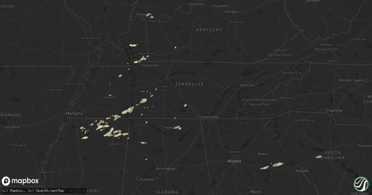
Hail Map in Tennessee on May 14, 2024
Get this storm
May 14 map
$229
one time, instant access
Download today. No call, no setup
Keep the $229
Bought the map and want the full workflow? Apply the entire $229 to a subscription within 7 days. None of it is wasted.
Every map, not just this one
This buys you this map. Subscription and you get every map we run, in the markets you choose from a few cities to whole states to nationwide. Plus real-time alerts the moment a storm fires.
Contact data
Name, contact info, occupancy, even credit band for addresses in the footprint. You go from where it hit to who to call.
Become the source they trust
Unlimited branding weather history reports on demand. You already have the documented answer ready for the property owner, and you are the one who showed up with it.
Property data and RoofTrace estimates
Pull up any address you have got, its value and the exact code rules for that jurisdiction, straight from One Click Code. Then RoofTrace estimates the squares, pitch, and roof value, priced the way you price.
Storm reports in Tennessee
Tennessee
| Date | Description |
|---|---|
| 05/14/20245:37 PM CDT | Trees down on normandy road in normandy and along highway 269 south of normandy. |
| 05/14/20245:37 PM CDT | Trees down on normandy road in normandy and along highway 269 south |
| 05/14/20245:36 PM CDT | Tree down on cascade hollow road. |
| 05/14/20245:35 PM CDT | Tree down on hwy 269. |
| 05/14/20245:27 PM CDT | Report of a tree down across flat creek hwy from moore county ema. |
| 05/14/20245:25 PM CDT | Report from broadcast media of a tree down on tanyard hill rd in moore county... Tn. |
| 05/14/20245:23 PM CDT | A downed power line was reported by moore county ema at the intersection of shelbyville hwy and charity rd. |
| 05/14/20245:00 PM CDT | Tree down on snake creek road. |
| 05/14/20245:00 PM CDT | Tree down on webb road. |
| 05/14/20244:56 PM CDT | Tree on hwy. |
| 05/14/20244:20 PM CDT | House with roof damage. |
| 05/14/20244:19 PM CDT | Large tree uprooted on east edan road near ethridge. |
| 05/14/20244:19 PM CDT | Multiple large uprooted trees on jap lane. |
| 05/14/20244:14 PM CDT | Reports of multiple barns destroyed on east edan road... Northeast of ethridge. |
| 05/14/20244:09 PM CDT | Large tree blocking north bound lane of tn 242. 2535 buffalo road. |
| 05/14/20243:47 PM CDT | Report from mping: quarter |
| 05/14/20242:55 PM CDT | Quarter size hail in crump. |
All States Impacted by Hail Map on May 14, 2024
Cities Impacted by Hail Map on May 14, 2024
- Lake Panasoffkee, FL
- Wildwood, FL
- Palm Harbor, FL
- Crystal Beach, FL
- Tarpon Springs, FL
- Dade City, FL
- Tampa, FL
- Deland, FL
- Edgewater, FL
- Coldwater, MS
- Holly Springs, MS
- Lamar, MS
- Byhalia, MS
- Senatobia, MS
- Michigan City, MS
- Ashland, MS
- Stantonville, TN
- Adamsville, TN
- Hickory Flat, MS
- Blue Mountain, MS
- Ripley, MS
- Falkner, MS
- Middleton, TN
- Batesville, MS
- Sardis, MS
- Oxford, MS
- Walnut, MS
- Como, MS
- Pocahontas, TN
- Savannah, TN
- Crump, TN
- Tiplersville, MS
- Ramer, TN
- Corinth, MS
- Olivehill, TN
- Booneville, MS
- Michie, TN
- Shiloh, TN
- Myrtle, MS
- Dumas, MS
- Edgemont, SD
- Guys, TN
- Selmer, TN
- Clifton, TN
- Waynesboro, TN
- New Albany, MS
- Counce, TN
- Guntown, MS
- Baldwyn, MS
- Eddyville, KY
- Kuttawa, KY
- Blue Springs, MS
- Princeton, KY
- Hohenwald, TN
- Chadron, NE
- Dover, TN
- Marietta, MS
- New Site, MS
- Saltillo, MS
- Santa Fe, TN
- Williamsport, TN
- Primm Springs, TN
- Bumpus Mills, TN
- Stonefort, IL
- Ozark, IL
- Murray, KY
- Norris, SD
- Springville, TN
- Buchanan, TN
- Iron City, TN
- Tishomingo, MS
- Cadiz, KY
- Dennis, MS
- Hay Springs, NE
- Rushville, NE
- Hampshire, TN
- Duck River, TN
- Batesland, SD
- Franklin, TN
- Belmont, MS
- Big Rock, TN
- Herndon, KY
- Wanblee, SD
- Killen, AL
- Martin, SD
- La Fayette, KY
- Fort Campbell, KY
- Hopkinsville, KY
- Merriman, NE
- Milan, TN
- Eddyville, IL
- Ethridge, TN
- Henry, TN
- Paris, TN
- White River, SD
- Olmsted, IL
- Pembroke, KY
- La Center, KY
- Golden, MS
- Villa Ridge, IL
- Oak Grove, KY
- Peru, NY
- Cody, NE
- Bowling Green, KY
- Gordon, NE
- Karval, CO
- Stratton, NE
- Shelbyville, TN
- Nenzel, NE
- Kilgore, NE
- Trenton, NE
- Moorefield, NE
- Tullahoma, TN
- Estill Springs, TN
- Wood, SD
- Flintville, TN
- Hazel Green, AL
- Culbertson, NE
- Manchester, TN
- Farnam, NE
- Jackson, TN
- Mission, SD
- Okreek, SD
- Phil Campbell, AL
- Bear Creek, AL
- Haleyville, AL
- Owens Cross Roads, AL
- Huntsville, AL
- Brownsboro, AL
- Gurley, AL
- Winner, SD
- San Angelo, TX
- Taylor, NE
- Paint Rock, AL
- Springview, NE
- Clarkton, NC
- Atwood, KS
- Melbourne, FL
- Mills, NE
- Palm City, FL
- Merritt Island, FL
- Satellite Beach, FL
- Patrick Afb, FL
- Indialantic, FL
- Bassett, NE
- Wallace, NE
- Dickens, NE
- Newport, NE
- Stuart, NE
- Hanna, WY
- Long Pine, NE
- Burwell, NE
- Elk Mountain, WY
- Rock River, WY
- Bosler, WY
- Atkinson, NE
- Centerville, TN
- Evansville, IN
- Newburgh, IN
- Chandler, IN
- Lawrenceburg, TN
- Reed, KY
- Owensboro, KY
- Henderson, KY
- Colome, SD
- Dallas, SD
- Townley, AL
- Carbon Hill, AL
- Leoti, KS
- Dunning, NE
- North Platte, NE
- Brewster, NE
- Marienthal, KS
- Maxwell, NE
- Healy, KS
- Madison, GA
- Buckhead, GA
- Greensboro, GA
- Union Point, GA
- Garden City, KS
- Scott City, KS
- Crawfordville, GA
- Washington, GA
- Larned, KS
- Garfield, KS
- Pomona Park, FL
- Crescent City, FL
- Silver Springs, FL
- Bunnell, FL
- Oak Hill, FL
- Leesville, SC
- Batesburg, SC
- Gilbert, SC
- Lexington, SC
- Laredo, TX
- Realitos, TX
- Eustis, FL
- Umatilla, FL
- Paisley, FL
- Deltona, FL
- Lake Helen, FL
- New Smyrna Beach, FL
- Osteen, FL
- Red Bay, AL
- Rienzi, MS
- Potts Camp, MS


