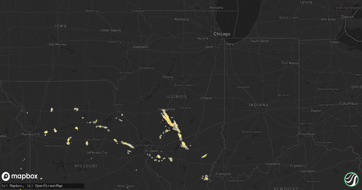
Hail Map in Illinois on May 14, 2023
Get this storm
May 14 map
$229
one time, instant access
Download today. No call, no setup
Keep the $229
Bought the map and want the full workflow? Apply the entire $229 to a subscription within 7 days. None of it is wasted.
Every map, not just this one
This buys you this map. Subscription and you get every map we run, in the markets you choose from a few cities to whole states to nationwide. Plus real-time alerts the moment a storm fires.
Contact data
Name, contact info, occupancy, even credit band for addresses in the footprint. You go from where it hit to who to call.
Become the source they trust
Unlimited branding weather history reports on demand. You already have the documented answer ready for the property owner, and you are the one who showed up with it.
Property data and RoofTrace estimates
Pull up any address you have got, its value and the exact code rules for that jurisdiction, straight from One Click Code. Then RoofTrace estimates the squares, pitch, and roof value, priced the way you price.
Storm reports in Illinois
Illinois
| Date | Description |
|---|---|
| 05/14/20236:49 PM CDT | A local report indicates 1.50 inch wind near DIVERNON |
| 05/14/20235:32 PM CDT | A local report indicates 1.25 inch wind near 2 NE HARVEL |
| 05/14/20235:30 PM CDT | Time estimate from radar. |
| 05/14/20235:26 PM CDT | Report from mping: ping pong ball |
| 05/14/20235:25 PM CDT | Report from mping: half dollar |
| 05/14/20235:25 PM CDT | A local report indicates 1.75 inch wind near 3 NE HARVEL |
| 05/14/20235:18 PM CDT | 6in diameter tree limb off tree. Multiple tree limbs down. West of mascoutah... Il. |
| 05/14/20235:16 PM CDT | Delayed report. Photos on twitter show a tree split near its base leaning on a house. Time estimated from radar. |
| 05/14/20235:15 PM CDT | A local report indicates 1.00 inch wind near 4 N HARVEL |
| 05/14/20235:13 PM CDT | A local report indicates 1.00 inch wind near 4 N HARVEL |
| 05/14/20234:52 PM CDT | A local report indicates 1.00 inch wind near 4 SSW SHILOH |
| 05/14/20234:42 PM CDT | A local report indicates 1.50 inch wind near PAWNEE |
| 05/14/20234:40 PM CDT | Couple large power poles and lines leaning on route 104 near pawnee. |
| 05/14/20234:40 PM CDT | Report from mping: 3-inch tree limbs broken; power poles broken. |
| 05/14/20234:39 PM CDT | Two power poles leaning to the south. |
| 05/14/20234:36 PM CDT | Report from mping: quarter |
| 05/14/20234:22 PM CDT | Quarter to half dollar size hail and gusty winds. Social media report via twitter. |
| 05/14/20234:20 PM CDT | Report from mping: half dollar |
| 05/14/20234:18 PM CDT | Corrects previous hail report from 3 ssw chatham. Report from mping: quarter |
| 05/14/20234:18 PM CDT | Report from mping: 3-inch tree limbs broken; power poles broken. |
| 05/14/20234:18 PM CDT | Report from mping: quarter |
| 05/13/20237:53 PM CDT | Tree down on power line. Time estimated by radar. |
| 05/13/20237:40 PM CDT | Time estimated from radar. Mostly penny and nickel sized hail... But a few quarter sized pieces. |
| 05/13/20237:37 PM CDT | A local report indicates 1.00 inch wind near 5 SW MORRISONVILLE |
| 05/13/20237:28 PM CDT | A local report indicates 1.75 inch wind near 5 SSE WHITE OAK |
| 05/13/20237:11 PM CDT | A local report indicates 1.25 inch wind near 2 SE SAINT PAUL |
| 05/13/20237:04 PM CDT | A local report indicates 1.00 inch wind near 1 E WHITE OAK |
| 05/13/20237:03 PM CDT | Public report hail up to the size of quarters. |
All States Impacted by Hail Map on May 14, 2023
Cities Impacted by Hail Map on May 14, 2023
- Wills Point, TX
- Prairie Home, MO
- Jamestown, MO
- Wooldridge, MO
- Montgomery City, MO
- Glasgow, MO
- Gilliam, MO
- New Florence, MO
- Thompson, MO
- Madison, MO
- Holliday, MO
- Chatham, IL
- Springfield, IL
- Glenarm, IL
- Divernon, IL
- Pawnee, IL
- Wright City, MO
- Foristell, MO
- Morrisonville, IL
- Harvel, IL
- Nokomis, IL
- Freeburg, IL
- Belleville, IL
- Benedict, KS
- Hartford, KS
- Girard, KS
- Burlington, KS
- Bingham, IL
- Ramsey, IL
- Orrick, MO
- Camden, MO
- Napoleon, MO
- Wellington, MO
- Frankford, MO
- Mexico, MO
- Clifton Hill, MO
- Shell Knob, MO
- Berryville, AR
- Palmer, IL
- Taylorville, IL
- Warrenton, MO
- Truesdale, MO
- Centralia, MO
- Glendale, UT
- Crane, MO
- Aurora, MO
- Henley, MO
- Eugene, MO
- Toquerville, UT
- La Verkin, UT
- Moberly, MO
- New Berlin, IL
- Verona, MO
- Green Forest, AR
- Hurricane, UT
- Agency, MO
- Saint Joseph, MO
- Easton, MO
- Bucklin, MO
- Pittsburg, TX
- Brookfield, MO
- La Cygne, KS
- Fontana, KS
- Greenville, MO
- Bluejacket, OK
- Miami, OK
- Burns, TN
- White Bluff, TN
- Black, MO
- Cadet, MO
- Blackwell, MO
- Benton City, MO
- Rush Hill, MO
- Virden, IL
- New London, MO
- Salisbury, MO
- Marionville, MO
- Huntsville, MO
- Fredonia, KS
- Jonesburg, MO
- Gerald, MO
- Auburn, IL
- Billings, MO
- Broken Arrow, OK
- Bixby, OK
- Farmersville, IL
- Clark, MO
- Nevada, MO
- Kincaid, IL
- Escalante, UT
- Okawville, IL
- Vandalia, IL
- Shobonier, IL
- Alma, IL
- Kinmundy, IL
- Vernon, IL
- Henrietta, MO
- Dover, MO
- Patoka, IL
- Litchfield, IL
- Butler, IL
- Worden, IL
- Hamel, IL
- Bunker Hill, IL
- Staunton, IL
- Breckenridge, MO
- Cecil, AR
- Irving, IL
- Huntington, UT
- Nashville, IL
- Addieville, IL
- Fairfield, IL
- Mount Erie, IL
- Golden Gate, IL
- Cisne, IL
- Geff, IL
- Witt, IL
- Columbia, IL
- Augusta, MO
- Marthasville, MO
- Bates City, MO
- Odessa, MO
- New Athens, IL
- Mulberry Grove, IL
- Houstonia, MO
- Marshall, MO
- Ridgway, IL
- Salem, IL
- Omaha, IL
- Corder, MO
- Norborne, MO
- Lexington, MO
- Higginsville, MO
- Waverly, MO
- Kinderhook, IL
- Hull, IL
- Hannibal, MO
- Loami, IL
- Hughesville, MO
- Sedalia, MO
- Wentzville, MO
- New Haven, IL
- Lavaca, AR
- Fort Smith, AR
- Charleston, AR
- Greenwood, AR
- Beryl, UT
- Norris City, IL
- Richmond, MO
- Girard, IL
- Morganfield, KY
- Raymond, IL
- Blue Mound, KS
- Mound City, KS
- Rosamond, IL
- Fillmore, IL
- Defiance, MO
- Ozark, AR
- El Dorado Springs, MO
- Lebo, KS
- Montgomery, AL
- Washington, MO
- East Carondelet, IL
- Mascoutah, IL
- Marissa, IL
- Eldorado, IL
- Shawneetown, IL
- Junction, IL
- Lenzburg, IL
- Mount Olive, IL
- Gillespie, IL
- Wilsonville, IL
- Waterloo, IL
- Smithton, IL
- Millstadt, IL
- Saint Louis, MO
- Ferron, UT
- Lebanon, IL
- Brownstown, IL
- Pleasant Plains, IL


