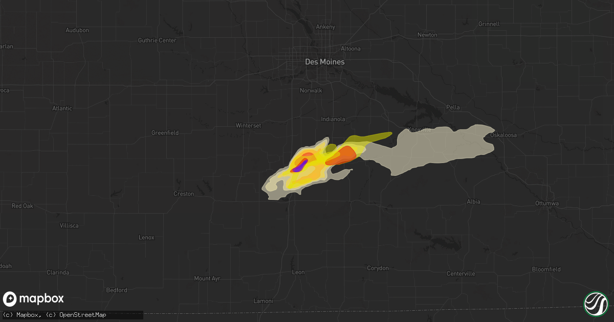
Hail Map in New Virginia, IA on May 14, 2020
Get this storm
May 14 map
$229
one time, instant access
Download today. No call, no setup
Keep the $229
Bought the map and want the full workflow? Apply the entire $229 to a subscription within 7 days. None of it is wasted.
Every map, not just this one
This buys you this map. Subscription and you get every map we run, in the markets you choose from a few cities to whole states to nationwide. Plus real-time alerts the moment a storm fires.
Contact data
Name, contact info, occupancy, even credit band for addresses in the footprint. You go from where it hit to who to call.
Become the source they trust
Unlimited branding weather history reports on demand. You already have the documented answer ready for the property owner, and you are the one who showed up with it.
Property data and RoofTrace estimates
Pull up any address you have got, its value and the exact code rules for that jurisdiction, straight from One Click Code. Then RoofTrace estimates the squares, pitch, and roof value, priced the way you price.
Storm reports in New Virginia, IA
New Virginia, IA
| Date | Description |
|---|---|
| 05/14/20204:30 PM CDT | A local report indicates 3.00 inch wind near NEW VIRGINIA |
| 05/14/20204:24 PM CDT | 1.5 miles northwest of medora... Iowa. |
| 05/14/20204:22 PM CDT | Delayed report and time estimated by radar. Report via woi-dt weather and social media. |
| 05/14/20204:19 PM CDT | . |
| 05/14/20204:18 PM CDT | . |
All States Impacted by Hail Map on May 14, 2020
All Cities Impacted by Hail Map on May 14, 2020
- Corydon, IA
- Chariton, IA
- Humeston, IA
- Russell, IA
- Melrose, IA
- Burlington, KS
- Hartford, KS
- Wamego, KS
- Winigan, MO
- Purdin, MO
- Browning, MO
- King City, MO
- Pueblo, CO
- Rose Hill, KS
- Douglass, KS
- Andover, KS
- Derby, KS
- Augusta, KS
- Knoxville, IA
- La Harpe, KS
- Iola, KS
- Kim, CO
- Kissee Mills, MO
- Americus, KS
- Emporia, KS
- Cottonwood Falls, KS
- Dryden, TX
- Tallulah, LA
- Iowa, LA
- Lake Charles, LA
- Solo, MO
- Cabool, MO
- Elk Creek, MO
- Fowler, CO
- Rocky Ford, CO
- Richland, IA
- Washington, IA
- Fairfield, IA
- Wayland, IA
- Mount Pleasant, IA
- Brighton, IA
- Council Grove, KS
- Arnett, OK
- Alden, KS
- Sterling, KS
- Nauvoo, IL
- Alexandria, MO
- Saint Patrick, MO
- Keokuk, IA
- Montrose, IA
- Argyle, IA
- Wayland, MO
- Kahoka, MO
- Cimarron, KS
- Nickerson, KS
- Isabella, OK
- Herscher, IL
- Buckingham, IL
- Graham, MO
- Maryville, MO
- Martinsville, MO
- Skidmore, MO
- Hopkins, MO
- Worth, MO
- Bedford, IA
- Conception Junction, MO
- Sheridan, MO
- Albany, MO
- Parnell, MO
- Denver, MO
- Burlington Junction, MO
- Ravenwood, MO
- Hatfield, MO
- Pickering, MO
- Grant City, MO
- Ollie, IA
- Packwood, IA
- Keota, IA
- Enterprise, KS
- Gypsum, KS
- Abilene, KS
- Hope, KS
- Haven, KS
- Mount Hope, KS
- Springfield, MO
- Nixa, MO
- Ozark, MO
- Rogersville, MO
- Ottumwa, IA
- Roseville, IL
- Norwalk, IA
- Prole, IA
- Burdick, KS
- Wilsey, KS
- Spearville, KS
- New Virginia, IA
- Lucas, IA
- Liberty Center, IA
- Murray, IA
- Woodburn, IA
- Lacona, IA
- Osceola, IA
- Milo, IA
- Indianola, IA
- Truro, IA
- McGehee, AR
- Union Star, MO
- Allen, KS
- Berwick, IL
- Effingham, KS
- Strafford, MO
- Mentone, IN
- Tippecanoe, IN
- Benton, KS
- Bartlesville, OK
- Alta Vista, KS
- Broken Arrow, OK
- Edina, MO
- Wildwood, MO
- Saint Albans, MO
- Pacific, MO
- Chillicothe, MO
- Eureka, KS
- El Dorado, KS
- Rosalia, KS
- Summersville, MO
- Eminence, MO
- Adel, IA
- Jamesport, MO
- Sigourney, IA
- Elmdale, KS
- Warsaw, IN
- Etna Green, IN
- Chadwick, MO
- Garrison, MO
- New Cambria, MO
- Highlandville, MO
- Goff, KS
- Wetmore, KS
- New Hampton, MO
- Clyde, MO
- Bethany, MO
- Stanberry, MO
- Gentry, MO
- Barnard, MO
- Sedgwick, KS
- Chanute, KS
- Yates Center, KS
- Clever, MO
- Billings, MO
- Sparta, MO
- Republic, MO
- Brookline, MO
- Muscotah, KS
- Whiting, KS
- Cherryvale, KS
- Neodesha, KS
- Thayer, KS
- Alma, KS
- Fairview, OK
- Saint Charles, IA
- Las Animas, CO
- La Junta, CO
- Hutchinson, KS
- Gilman City, MO
- Chester, OK
- Toluca, IL
- Varna, IL
- Washburn, IL
- Albia, IA
- Eddyville, IA
- Kirkville, IA
- Saint Marys, KS
- South Hutchinson, KS
- Offerle, KS
- Kinsley, KS
- Linneus, MO
- Meadville, MO
- Laclede, MO
- Hale, MO
- Brookfield, MO
- Wheeling, MO
- Holton, KS
- Raymond, KS
- Pontiac, IL
- Long Point, IL
- Cornell, IL
- Odell, IL
- Dwight, IL
- Streator, IL
- Flanagan, IL
- Memphis, MO
- New Boston, MO
- Raritan, IL
- Sciota, IL
- Smithshire, IL
- Good Hope, IL
- Monmouth, IL
- Blandinsville, IL
- Moline, KS
- Maysville, MO
- La Grange, IL
- Brookfield, IL
- Western Springs, IL
- Riverside, IL
- La Grange Park, IL
- Lyons, IL
- Chamois, MO
- Montrose, MO
- Clinton, MO
- Sedan, KS
- Cedar Vale, KS
- White City, KS
- Strong City, KS
- Junction City, KS
- Dwight, KS
- Clarinda, IA
- Villisca, IA
- Wichita, KS
- Excello, MO
- Bevier, MO
- Osage City, KS
- Burlingame, KS
- Ballwin, MO
- Neosho Falls, KS
- Salisbury, MO
- Marceline, MO
- Lyndon, KS
- Melvern, KS
- Leon, KS
- Columbia, IA
- Galesburg, IL
- Abingdon, IL
- Ash Grove, MO
- Mount Vernon, MO
- Pleasant Hope, MO
- Willard, MO
- Brighton, MO
- Melcher Dallas, IA
- Madisonville, TX
- Midway, TX
- Fayette, MO
- Reading, KS
- Plevna, KS
- Sylvia, KS
- Walton, KS
- Newton, KS
- Halstead, KS
- Hesston, KS
- Woodbine, KS
- McFall, MO
- Chula, MO
- Inman, KS
- Fulton, MO
- Buhler, KS
- Humboldt, KS
- Benedict, KS
- Erie, KS
- Eskridge, KS
- Havensville, KS
- Herington, KS
- Armstrong, MO
- Lees Summit, MO
- Kansas City, MO
- Catoosa, OK
- Norco, LA
- Boutte, LA
- Saint Rose, LA
- Ama, LA
- Luling, LA
- Hahnville, LA
- Destrehan, LA
- Boone, CO
- Avondale, CO
- Piqua, KS
- Cabery, IL
- Cullom, IL
- Emington, IL
- Kempton, IL
- Marion, KS
- Belpre, KS
- Elk Falls, KS
- Bussey, IA
- Onaga, KS
- Trinity, TX
- Fremont, IA
- Delta, IA
- Rose Hill, IA
- Niota, IL
- Novinger, MO
- Lenapah, OK
- Darlington, MO
- Bucklin, MO
- Mcconnell Afb, KS
- Burns, KS
- Atlanta, KS
- Towanda, KS
- Cassoday, KS
- Columbus Junction, IA
- Chebanse, IL
- Rea, MO
- Helena, MO
- Pattonsburg, MO
- Howard, KS
- Netawaka, KS
- Horton, KS
- Powhattan, KS
- Circleville, KS
- Piedmont, KS
- Cambridge, KS
- Latham, KS
- Van Meter, IA
- Avilla, IN
- Churubusco, IN
- Albion, IN
- Wyaconda, MO
- Laredo, MO
- Williamson, IA
- Hinsdale, IL
- Clarendon Hills, IL
- Westmont, IL
- Oak Brook, IL
- Gilson, IL
- Knoxville, IL
- Cameron, IL
- Coatsville, MO
- Queen City, MO
- Moulton, IA
- Glenwood, MO
- Livonia, MO
- Unionville, MO
- Green Castle, MO
- Milan, MO
- Saint George, KS
- Belvue, KS
- Oldfield, MO
- La Place, LA
- Ulysses, KS
- Satanta, KS
- Garden City, KS
- Blairstown, MO
- Jetmore, KS
- Cedar Point, KS
- Biggsville, IL
- Media, IL
- Trenton, MO
- Pleasant Hill, IL
- Pittsfield, IL
- Ames, OK
- Crawfordsville, IA
- Cedar, IA
- Hedrick, IA
- Oskaloosa, IA
- Winfield, IA
- Martinsburg, IA
- Blakesburg, IA
- Ainsworth, IA
- Chillicothe, IA
- Hayesville, IA
- Agency, IA
- Chicago, IL
- Independence, KS
- Sulphur, LA
- Kirksville, MO
- Elmer, MO
- Gibbs, MO
- La Plata, MO
- Ethel, MO
- Callao, MO
- Brashear, MO
- Atlanta, MO
- Greensburg, KS
- Bucklin, KS
- Hamilton, MO
- Pierceville, KS
- Portland, MO
- Rhineland, MO
- Savonburg, KS
- Elsmore, KS
- Moran, KS
- Dennis, KS
- Tampico, IL
- Rock Falls, IL
- Rockport, IL
- Dermott, AR
- Sweet Springs, MO
- Marshall, MO
- Fort Scott, KS
- Drury, MO
- Orange, TX
- Thibodaux, LA
- Leighton, IA
- Tracy, IA
- Miami, OK
- Falls City, NE
- Colwich, KS
- Welsh, LA
- Kinder, LA
- North Webster, IN
- Pierceton, IN
- Syracuse, IN
- Winona Lake, IN
- Leesburg, IN
- Elk City, KS
- Waverly, MO
- Ponchatoula, LA
- Kirbyville, MO
- Taneyville, MO
- Partridge, KS
- Princeton, IA
- Le Claire, IA
- Cordova, IL
- Whitewater, MO
- Beaumont, KS
- Waverly, KS
- Rohwer, AR
- Plano, IL
- Sandwich, IL
- Hiawatha, KS
- Bell City, LA
- Berrien Springs, MI
- Eau Claire, MI
- Berrien Center, MI
- Gallatin, MO
- Jameson, MO
- Moundridge, KS
- Burrton, KS
- Olpe, KS
- Madison, KS
- Haysville, KS
- Pilot Grove, MO
- Nelson, MO
- Bois D Arc, MO
- Boonville, MO
- Ramona, OK
- Mountain Grove, MO
- Oquawka, IL
- Mayetta, KS
- Holden, MO
- Lincolnville, KS
- Cedarcreek, MO
- Corning, KS
- Liberty, KS
- Edna, KS
- Coffeyville, KS
- Seymour, MO
- University Park, IA
- Le Roy, KS
- Adair, IA
- Anita, IA
- Walnut Shade, MO
- Chestnutridge, MO
- Rutledge, MO
- Longton, KS
- Wann, OK
- Arbela, MO
- Mansfield, MO
- Rio, IL
- North Henderson, IL
- Clifton Hill, MO
- Huntsville, MO
- Valley Falls, KS
- Denison, KS
- Jackson, MO
- Erie, IL
- Fulton, IL
- Albany, IL
- Gibson, LA
- Valley Center, KS
- Luray, MO
- Chilhowee, MO
- Ford, KS
- Wright, KS
- Bunker, MO
- Madisonville, LA
- Versailles, MO
- St John, KS
- Pella, IA
- Hamilton, IA
- Harvey, IA
- Syracuse, MO
- Florence, MO
- Fortuna, MO
- Potwin, KS
- Salem, NE
- Tulsa, OK
- Sawyer, MI
- Three Oaks, MI
- Momence, IL
- Soldier, KS
- Wawaka, IN
- Rome City, IN
- Whitewater, KS
- Pritchett, CO
- Trinidad, CO
- Model, CO
- Vinita, OK
- Delaware, OK
- Bruner, MO
- Fordland, MO
- Pollock, MO
- Abbyville, KS
- Bolckow, MO
- Guilford, MO
- Malta Bend, MO
- Peabody, KS
- Maize, KS
- Abbeville, LA
- Erath, LA
- Dodge City, KS
- Tingley, IA
- Ellston, IA
- Kechi, KS
- Raymond, OH
- Marysville, OH
- Baring, MO
- Wiota, IA
- Bourbonnais, IL
- Morgan City, LA
- Blue Springs, MO
- Grain Valley, MO
- Lewis, KS
- Ava, MO
- Norwood, MO
- Columbus, OH
- Westerville, OH
- Hollister, MO
- Emmett, KS
- Marble Hill, MO
- Admire, KS
- Kankakee, IL
- Bonfield, IL
- Chapman, KS
- Lebo, KS
- Thayer, IA
- Westphalia, KS
- Peru, IA
- Seneca, KS
- Winterset, IA
- Macon, MO
- Centerview, MO
- Fair Grove, MO
- Alpha, IL
- Oneida, IL
- Toronto, KS
- Minonk, IL
- El Paso, IL
- Caney, KS
- Youngsville, LA
- New Iberia, LA
- Labadie, MO
- Des Allemands, LA
- Menlo, IA
- Stuart, IA
- Casey, IA
- Grenola, KS
- Delia, KS
- Morrison, MO
- Morrison, IL
- Lyndon, IL
- Fenton, IL
- Larned, KS
- Welch, OK
- Weldon, IA
- Buffalo, KS
- Dana, IL
- Blackstone, IL
- Lemont, IL
- Princeton, MO
- Nowata, OK
- Warrensburg, MO
- Dewey, OK
- Derby, IA
- Breckenridge, MO
- Dawn, MO
- New Canton, IL
- Galena, OH
- Sunbury, OH
- Weatherby, MO
- Delaware, OH
- Hurdland, MO
- Mooresville, MO
- Assaria, KS
- Gridley, KS
- Elbing, KS
- Udall, KS
- McCausland, IA
- Long Grove, IA
- Ridgeway, MO
- Greentop, MO
- Olds, IA
- Sharon, OK
- Shattuck, OK
- Fargo, OK
- Ringwood, OK
- Carman, IL
- Burlington, IA
- Stronghurst, IL
- Kewanee, IL
- Cambridge, IL
- Mineral, IL
- Annawan, IL
- Sheffield, IL
- Atkinson, IL
- Neponset, IL
- Dahinda, IL
- Maquon, IL
- Brimfield, IL
- Williamsfield, IL
- Elmwood, IL
- Leland, IL
- Waterman, IL
- Arlington, IL
- Montgomery, IL
- Amboy, IL
- Troy Grove, IL
- Mendota, IL
- La Moille, IL
- Compton, IL
- Manlius, IL
- Somonauk, IL
- Sugar Grove, IL
- West Brooklyn, IL
- Elburn, IL
- Malta, IL
- Batavia, IL
- Walnut, IL
- Bristol, IL
- Hinckley, IL
- Dekalb, IL
- Earlville, IL
- Princeton, IL
- Harmon, IL
- Van Orin, IL
- Maple Park, IL
- Steward, IL
- Aurora, IL
- Triumph, IL
- Wyanet, IL
- New Bedford, IL
- Lee, IL
- Paw Paw, IL
- Deer Grove, IL
- Malden, IL
- Sublette, IL
- Shabbona, IL
- Ohio, IL
- Big Rock, IL
- North Aurora, IL
- Oswego, IL
- Grant Park, IL
- East Galesburg, IL
- Altona, IL
- Victoria, IL
- Wataga, IL
- La Cygne, KS
- Parker, KS
- Neosho Rapids, KS
- Richmond, KS
- Greeley, KS
- Princeton, KS
- Osawatomie, KS
- Rantoul, KS
- Fontana, KS
- Quenemo, KS
- Centerville, KS
- Garnett, KS
- Paola, KS
- Ottawa, KS
- Williamsburg, KS
- Lane, KS
- Pomona, KS
- Florence, KS
- Vassar, KS
- Overbrook, KS
- Scranton, KS
- Welda, KS
- Colony, KS
- Kincaid, KS
- Pandora, OH
- Fostoria, OH
- Bluffton, OH
- Alvada, OH
- Mount Cory, OH
- Rawson, OH
- Ottawa, OH
- Benton Ridge, OH
- Green Springs, OH
- Columbus Grove, OH
- Bascom, OH
- Arcadia, OH
- Tiffin, OH
- Findlay, OH
- Attica, OH
- Willard, OH
- North Fairfield, OH
- Monroeville, OH
- Republic, OH
- Mount Gilead, OH
- Bellville, OH
- Pleasantville, IA


