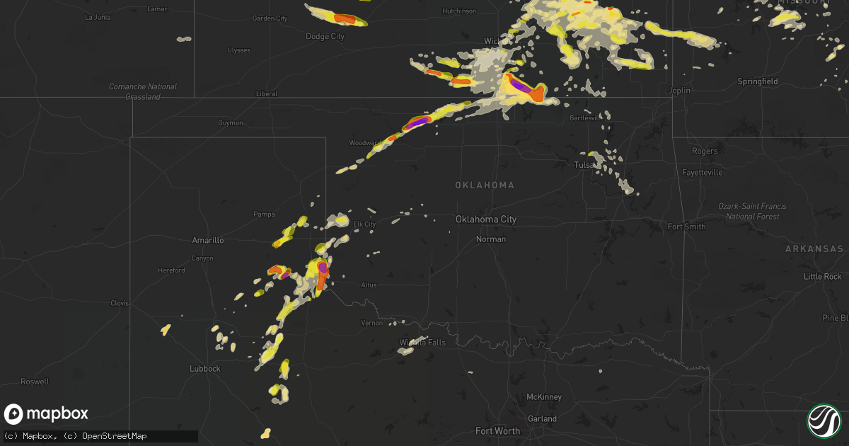
Hail Map in Oklahoma on May 14, 2018
Get this storm
May 14 map
$229
one time, instant access
Download today. No call, no setup
Keep the $229
Bought the map and want the full workflow? Apply the entire $229 to a subscription within 7 days. None of it is wasted.
Every map, not just this one
This buys you this map. Subscription and you get every map we run, in the markets you choose from a few cities to whole states to nationwide. Plus real-time alerts the moment a storm fires.
Contact data
Name, contact info, occupancy, even credit band for addresses in the footprint. You go from where it hit to who to call.
Become the source they trust
Unlimited branding weather history reports on demand. You already have the documented answer ready for the property owner, and you are the one who showed up with it.
Property data and RoofTrace estimates
Pull up any address you have got, its value and the exact code rules for that jurisdiction, straight from One Click Code. Then RoofTrace estimates the squares, pitch, and roof value, priced the way you price.
Storm reports in Oklahoma
Oklahoma
| Date | Description |
|---|---|
| 05/14/20186:58 PM CDT | Tree limb downed onto a fence |
| 05/14/20186:50 PM CDT | A local report indicates 65 MPH wind near 1 N TEXOLA |
| 05/14/20186:50 PM CDT | Relayed a report from a trained spotter. Unknown instrument. |
| 05/14/20186:35 PM CDT | A local report indicates 1.00 inch wind near 1 SE SHARON |
| 05/14/20186:20 PM CDT | A local report indicates 65 MPH wind near 1 S BERLIN |
| 05/14/20186:20 PM CDT | A local report indicates 1.00 inch wind near 1 W MADGE |
| 05/14/20187:06 AM CDT | At 1206 AM CDT, a severe thunderstorm was located near Friendship, moving northeast at 40 mph. HAZARD...60 mph wind gusts and quarter size hail. SOURCE...Radar indicated. IMPACT...Hail damage to vehicles is expected. Expect wind damage to roofs, siding, and trees. Locations impacted include... Snyder, Blair, Mountain Park, Roosevelt, Gotebo, Headrick, Friendship, Cooperton, Warren, Tom Steed Reservoir and Altus Air Force Base. |
| 05/14/20184:25 AM CDT | At 924 PM CDT, severe thunderstorms were located along a line extending from near Concho to 4 miles south of El Reno to near Cogar, moving east at 30 mph. Wind gusts of 35 to 45 mph will occur well ahead of the storms. HAZARD...60 mph wind gusts. SOURCE...Radar indicated. IMPACT...Expect damage to roofs, siding, and trees. Locations impacted include... Western Oklahoma City, El Reno, Yukon, Mustang, Tuttle, Piedmont, Union City, Minco, Cogar, Concho and Richland.This includes Interstate 40 between mile markers 117 and 141. |
| 05/14/20183:40 AM CDT | At 840 PM CDT, a severe thunderstorm was located near Bridgeport, moving east at 30 mph. HAZARD...70 mph wind gusts and nickel size hail. SOURCE...Radar indicated. IMPACT...Expect considerable tree damage. Damage is likely to mobile homes, roofs, and outbuildings. Locations impacted include... El Reno, Hinton, Union City, Minco, Geary, Calumet, Bridgeport, Cogar, Concho and Cedar Lake.This includes Interstate 40 between mile markers 96 and 126. |
| 05/14/20183:04 AM CDT | At 804 PM CDT, a severe thunderstorm was located near Weatherford, moving east at 35 mph. HAZARD...Ping pong ball size hail and 60 mph wind gusts. SOURCE...Radar indicated. IMPACT...People and animals outdoors will be injured. Expect hail damage to roofs, siding, windows, and vehicles. Expect wind damage to roofs, siding, and trees. Locations impacted include... Weatherford, Hinton, Geary, Hydro, Bridgeport and Greenfield. This includes Interstate 40 between mile markers 72 and 103. |
| 05/14/20182:53 AM CDT | At 752 PM CDT, severe thunderstorms were located along a line extending from 7 miles south of Elk City to near Burns Flat, moving northeast at 20 mph. HAZARD...60 mph wind gusts and quarter size hail. SOURCE...Radar indicated. IMPACT...Hail damage to vehicles is expected. Expect wind damage to roofs, siding, and trees. Locations impacted include... Elk City, Clinton, Burns Flat, Dill City, Canute, Carter, Bessie and Foss.This includes Interstate 40 between mile markers 33 and 73. |
| 05/14/20182:47 AM CDT | At 746 PM CDT, a severe thunderstorm was located near Dacoma, moving northeast at 30 mph. HAZARD...Two inch hail and 60 mph wind gusts. SOURCE...Radar indicated. IMPACT...People and animals outdoors will be injured. Expect hail damage to roofs, siding, windows, and vehicles. Expect wind damage to roofs, siding, and trees. Locations impacted include... Cherokee, Burlington, Dacoma, Amorita, Byron, Lambert, Ingersoll, Great Salt Plains Lake, Driftwood, Waldron and Hopeton. |
| 05/14/20182:39 AM CDT | At 739 PM CDT, a severe thunderstorm was located near Hollis, moving northeast at 20 mph. HAZARD...60 mph wind gusts. SOURCE...Radar indicated. IMPACT...Expect damage to roofs, siding, and trees. Locations impacted include... Hollis, Gould, Vinson and McKnight. |
| 05/14/20182:19 AM CDT | At 719 PM CDT, a severe thunderstorm was located 6 miles northeast of Quinlan, moving northeast at 30 mph. HAZARD...Golf ball size hail. SOURCE...Radar indicated. IMPACT...People and animals outdoors will be injured. Expect damage to roofs, siding, windows, and vehicles. Locations impacted include... Alva, Waynoka, Dacoma, Avard, Hopeton and Bouse Junction. |
| 05/14/20182:18 AM CDT | At 718 PM CDT, a severe thunderstorm was located near Erick, moving northeast at 20 mph. HAZARD...60 mph wind gusts and quarter size hail. SOURCE...Radar indicated. IMPACT...Hail damage to vehicles is expected. Expect wind damage to roofs, siding, and trees. Locations impacted include... Sayre, Erick, Carter, Texola and Delhi. This includes Interstate 40 between mile markers 0 and 34. |
| 05/14/20181:56 AM CDT | At 655 PM CDT, a severe thunderstorm was located 4 miles northeast of Arkansas City, moving southeast at 20 mph. HAZARD...Two inch hail and 70 mph wind gusts. SOURCE...Radar indicated. IMPACT...People and animals outdoors will be injured. Expect hail damage to roofs, siding, windows, and vehicles. Expect considerable tree damage. Wind damage is also likely to mobile homes, roofs, and outbuildings. Locations impacted include... Hardy and northeastern Kaw Lake. |
| 05/14/20181:53 AM CDT | At 653 PM CDT, a severe thunderstorm was located near Dodson, or 7 miles west of Hollis, moving northeast at 25 mph. HAZARD...70 mph wind gusts. SOURCE...Radar indicated. IMPACT...Expect considerable tree damage. Damage is likely to mobile homes, roofs, and outbuildings. Locations impacted include... Childress and Kirkland. |
| 05/14/20181:42 AM CDT | At 641 PM CDT, a severe thunderstorm was located 6 miles northeast of Sharon, moving northeast at 20 mph. HAZARD...Hail up to ping pong ball size. SOURCE...Radar indicated. IMPACT...People and animals outdoors will be injured. Expect damage to roofs, siding, windows, and vehicles. Locations impacted include... Mooreland, Mutual, Quinlan and Bouse Junction. |
| 05/14/20181:14 AM CDT | At 614 PM CDT, a severe thunderstorm was located near Erick, moving east at 20 mph. HAZARD...70 mph wind gusts and quarter size hail. SOURCE...Radar indicated. IMPACT...Hail damage to vehicles is expected. Expect considerable tree damage. Wind damage is also likely to mobile homes, roofs, and outbuildings. Locations impacted include... Elk City, Sayre, Erick, Carter, Texola and Delhi. This includes Interstate 40 between mile markers 0 and 28. |
| 05/14/20181:09 AM CDT | At 609 PM CDT, a severe thunderstorm was located near Arnett, moving northeast at 35 mph. HAZARD...Ping pong ball size hail and 60 mph wind gusts. SOURCE...Radar indicated. IMPACT...People and animals outdoors will be injured. Expect hail damage to roofs, siding, windows, and vehicles. Expect wind damage to roofs, siding, and trees. Locations impacted include... Arnett, Vici, Camargo, Sharon and Harmon. |
| 05/14/20181:06 AM CDT | At 606 PM CDT, a severe thunderstorm was located 7 miles northeast of Northfield, or 16 miles west of Childress, moving northeast at 55 mph. HAZARD...60 mph wind gusts and quarter size hail. SOURCE...Radar indicated. IMPACT...Hail damage to vehicles is expected. Expect wind damage to roofs, siding, and trees. Locations impacted include... Childress, Memphis, Northfield, Tell and Estelline. |
| 05/14/20181:05 AM CDT | At 605 PM CDT, a severe thunderstorm was located 8 miles east of Sweetwater, moving east at 25 mph. HAZARD...70 mph wind gusts and quarter size hail. SOURCE...Radar indicated. IMPACT...Hail damage to vehicles is expected. Expect considerable tree damage. Wind damage is also likely to mobile homes, roofs, and outbuildings. Locations impacted include... Elk City, Cheyenne, Hammon, Berlin and Dempsey. |
| 05/14/201812:57 AM CDT | At 557 PM CDT, a severe thunderstorm was located near Dodson, moving north at 20 mph. HAZARD...Ping pong ball size hail and 60 mph wind gusts. SOURCE...Radar indicated. IMPACT...People and animals outdoors will be injured. Expect hail damage to roofs, siding, windows, and vehicles. Expect wind damage to roofs, siding, and trees. Locations impacted include... Vinson, Madge and McKnight. |
| 05/14/201812:49 AM CDT | A local report indicates 1.00 inch wind near 2 N OWASSO |
| 05/14/201812:37 AM CDT | At 537 PM CDT, a severe thunderstorm was located 11 miles southwest of Hollis, moving northeast at 35 mph. HAZARD...60 mph wind gusts and half dollar size hail. SOURCE...Radar indicated. IMPACT...Hail damage to vehicles is expected. Expect wind damage to roofs, siding, and trees. This severe thunderstorm will remain over mainly rural areas of northeastern Childress County. |
| 05/14/201812:30 AM CDT | At 529 PM CDT, a severe thunderstorm was located 4 miles northwest of Vinson, moving north-northeast at 15 mph. HAZARD...Ping pong ball size hail and 60 mph wind gusts. SOURCE...Radar indicated. IMPACT...People and animals outdoors will be injured. Expect hail damage to roofs, siding, windows, and vehicles. Expect wind damage to roofs, siding, and trees. Locations impacted include... Erick, Texola, Delhi, Vinson and Madge. This includes Interstate 40 between mile markers 0 and 21. |
| 05/13/201811:29 PM CDT | At 428 PM CDT, a severe thunderstorm was located 4 miles southwest of Hedley, or 11 miles southeast of Clarendon, moving northeast at 15 mph. HAZARD...Ping pong ball size hail and 60 mph wind gusts. SOURCE...Radar indicated. IMPACT...Minor damage to roofs, siding, and trees is possible. People and animals outdoors will be injured. Expect hail damage to roofs, siding, windows, and vehicles. Locations impacted include... Wellington, Shamrock, Hedley, Dodson, Lutie, Lelia Lake, Dozier, Lela, Quail and Samnorwood. |
| 05/13/201811:10 PM CDT | A local report indicates 59 MPH wind near 2 ENE COPAN |
| 05/13/201811:10 PM CDT | Damage to road signs. Roof damage to a church building. Power line also blown down. Road sign and roof damage relayed by broadcast media. Power line information relayed |
| 05/13/201810:49 PM CDT | At 348 PM CDT, a severe thunderstorm was located 4 miles north of Mclean, or 19 miles west of Shamrock, moving northeast at 15 mph. HAZARD...Ping pong ball size hail and 60 mph wind gusts. SOURCE...Radar indicated. IMPACT...Minor damage to roofs, siding, and trees is possible. People and animals outdoors will be injured. Expect hail damage to roofs, siding, windows, and vehicles. Locations impacted include... Shamrock, Briscoe, Wheeler, Mclean, New Mobeetie, Twitty, Allison, Lela, Alanreed, Kellerville and Mobeetie. |
| 05/13/201810:15 PM CDT | A local report indicates 69 MPH wind near 8 NNW KAW LAKE |
| 05/13/20189:35 PM CDT | Corrects previous tstm wnd gst report from 3 w medicine park. |
| 05/13/20189:20 PM CDT | Estimated 65-70 mph. |
| 05/13/20188:55 PM CDT | A local report indicates 60 MPH wind near 8 ENE HINTON |
| 05/13/20188:40 PM CDT | High voltage powerline down on road. |
| 05/13/20188:25 PM CDT | Late report. Trees and power lines down one and a half miles south of highway 11 on highway 38. Time of occurrence estimated by radar. |
| 05/13/20188:15 PM CDT | Corrects previous tstm wnd dmg report from 2 ene weatherford. Carport collapsed and tree limbs broken. Time estimate based on other nearby reports. |
| 05/13/20188:15 PM CDT | A local report indicates 66 MPH wind near 4 WSW WEATHERFORD |
| 05/13/20188:10 PM CDT | Late report. Wall of a building blown down on the north side of cherokee. Window blown out of another building in town. Tree limbs and power lines down. Time of occurre |
| 05/13/20188:10 PM CDT | A local report indicates 66 MPH wind near 1 SSW CHEROKEE |
| 05/13/20188:05 PM CDT | A local report indicates 1.00 inch wind near 4 S CLINTON |
| 05/13/20188:05 PM CDT | A local report indicates 64 MPH wind near 1 SSW CHEROKEE |
| 05/13/20187:50 PM CDT | A local report indicates 2.75 inch wind near DACOMA |
| 05/13/20187:33 PM CDT | Large wood-frame metal barn destroyed. Debris observed downwind about 200 yards. |
| 05/13/20187:05 PM CDT | Corrects previous tstm wnd dmg report from 3 e hollis. Large wood-frame metal barn destroyed. Debris observed downwind about 200 yards. |
| 05/13/20187:05 PM CDT | Roof blown off building. |
| 05/13/20187:05 PM CDT | A local report indicates 81 MPH wind near 3 W GOULD |
| 05/13/20187:00 PM CDT | Series of measured wind gusts of 58 to 81 mph between 7pm and 7:25pm |
All States Impacted by Hail Map on May 14, 2018
Cities Impacted by Hail Map on May 14, 2018
- North Baltimore, OH
- McComb, OH
- Mobeetie, TX
- Shamrock, TX
- Crown Point, IN
- Merrillville, IN
- Rileyville, VA
- Luray, VA
- Sperryville, VA
- Hollis, OK
- Syracuse, IN
- Deer Trail, CO
- Genoa, CO
- Limon, CO
- Montrose, WV
- Belington, WV
- Lebo, KS
- Mooreland, OK
- Chester, OK
- Sedalia, MO
- Hughesville, MO
- Rockbridge Baths, VA
- Lexington, VA
- Fairfield, VA
- Lamar, MO
- Sheldon, MO
- Kendallville, IN
- Albion, IN
- Arkansas City, KS
- Winfield, KS
- Eldridge, IA
- Davenport, IA
- Independence, MO
- Buckner, MO
- Sibley, MO
- Burlingame, KS
- Scranton, KS
- Carbondale, KS
- Lebanon, MO
- Menard, TX
- Hext, TX
- Mason, TX
- Afton, VA
- Mayetta, KS
- Robert Lee, TX
- Glasgow, MO
- Mora, MO
- Syracuse, MO
- Stover, MO
- Lincoln, MO
- Slater, MO
- Boonville, MO
- Ionia, MO
- Warsaw, MO
- Cole Camp, MO
- Fortuna, MO
- Blackwater, MO
- Smithton, MO
- Nelson, MO
- Florence, MO
- Clarksburg, MO
- Arrow Rock, MO
- Tipton, MO
- Versailles, MO
- Marshall, MO
- Houstonia, MO
- Franklin, MO
- Pilot Grove, MO
- Otterville, MO
- Bunceton, MO
- Clinton, MO
- Gilliam, MO
- Weatherford, OK
- Ashtabula, OH
- Austinburg, OH
- Jefferson, OH
- Alma, KS
- Paxico, KS
- Maple Hill, KS
- Eskridge, KS
- Allen, KS
- Alta Vista, KS
- Council Grove, KS
- Rushville, NE
- Pine Ridge, SD
- Steelville, MO
- Plainview, TX
- Sharon Springs, KS
- Glen Ellyn, IL
- Naperville, IL
- West Chicago, IL
- North Aurora, IL
- Winfield, IL
- Glendale Heights, IL
- Aurora, IL
- Batavia, IL
- Wheaton, IL
- Warrenville, IL
- Carol Stream, IL
- Bennett, CO
- Mexico, MO
- Odessa, MO
- Bates City, MO
- Holden, MO
- Cottonwood Falls, KS
- Memphis, TX
- Hedley, TX
- Lakeview, TX
- San Angelo, TX
- Hoyt, KS
- Topeka, KS
- Calhoun, MO
- Windsor, MO
- Mercer, MO
- Cainsville, MO
- Horton, KS
- Lancaster, KS
- Everest, KS
- Effingham, KS
- Richmond, VA
- Henrico, VA
- Ponca City, OK
- Blackwell, OK
- Kinsley, KS
- Offerle, KS
- Sinclairville, NY
- Cherry Creek, NY
- South Haven, KS
- Caldwell, KS
- Girard, TX
- Milton, FL
- Reston, VA
- Chantilly, VA
- Vienna, VA
- Herndon, VA
- Great Falls, VA
- Sterling, VA
- Mountain Grove, MO
- Ashburn, VA
- Ovid, CO
- Julesburg, CO
- Amherst, CO
- Cassoday, KS
- Junction City, KS
- White City, KS
- Dwight, KS
- Chariton, IA
- Garden Grove, IA
- Humeston, IA
- Corydon, IA
- Fulks Run, VA
- Hobart, IN
- Portage, IN
- Chesterton, IN
- Valparaiso, IN
- Marion, KY
- Arnett, OK
- Pennsboro, WV
- West Union, WV
- Atlanta, KS
- Rock, KS
- Douglass, KS
- Bethany, MO
- Larkspur, CO
- Patoka, IN
- Princeton, IN
- Owensville, IN
- Licking, MO
- Edgar Springs, MO
- Duke, MO
- Bosler, WY
- Miami, MO
- De Witt, MO
- Carrollton, MO
- Attica, KS
- Childress, TX
- Arapahoe, CO
- Cheyenne Wells, CO
- Wellington, TX
- Dodson, TX
- Weskan, KS
- Wallace, KS
- Leoti, KS
- Afton, TX
- Dickens, TX
- Hanston, KS
- Oak Brook, IL
- Hinsdale, IL
- Clarendon Hills, IL
- Decatur, IA
- Leon, IA
- Blythedale, MO
- Lamoni, IA
- Lineville, IA
- Allerton, IA
- Davis City, IA
- Holton, KS
- Bridgeport, WV
- Philippi, WV
- Ruckersville, VA
- Charlottesville, VA
- Earlysville, VA
- Barboursville, VA
- Dyke, VA
- Stanardsville, VA
- Clarendon, TX
- Mclean, TX
- Pampa, TX
- Prophetstown, IL
- Erie, IL
- Newburg, MO
- Auburn, WV
- Berea, WV
- Smithville, WV
- Harrisville, WV
- Wheeler, TX
- Pemberville, OH
- Wayne, OH
- Silverton, TX
- Zanesville, OH
- Adamsville, OH
- Agate, CO
- Eureka, KS
- Emporia, KS
- Strong City, KS
- Amherst, TX
- Sudan, TX
- Junction, TX
- Madison, MO
- Moberly, MO
- Tebbetts, MO
- Hamilton, KS
- Summit Point, WV
- Charles Town, WV
- Harpers Ferry, WV
- Kearneysville, WV
- Versailles, IL
- Jacksonburg, WV
- Bruington, VA
- Dunnsville, VA
- Tappahannock, VA
- Melvin, TX
- Ligonier, IN
- Cromwell, IN
- Graysville, OH
- Lewisville, OH
- Lower Salem, OH
- Galesburg, KS
- Parsons, KS
- Randolph, NY
- Spur, TX
- Saint Paul, KS
- Healy, KS
- Dighton, KS
- Scott City, KS
- Albin, WY
- Pine Bluffs, WY
- Oglala, SD
- Buffalo Gap, SD
- Oral, SD
- Lisle, IL
- Lombard, IL
- Downers Grove, IL
- Woodridge, IL
- Villa Park, IL
- Lone Jack, MO
- Mayview, MO
- Higginsville, MO
- Kingsville, MO
- Lyndon, KS
- Quenemo, KS
- Leon, KS
- Augusta, KS
- Altoona, KS
- Thayer, KS
- Covesville, VA
- Faber, VA
- Melvern, KS
- Olpe, KS
- Hartford, KS
- Inola, OK
- Pryor, OK
- Jerusalem, OH
- Beallsville, OH
- North Judson, IN
- Winamac, IN
- Thompson, MO
- Sterling City, TX
- Toluca, IL
- Varna, IL
- La Rose, IL
- Strasburg, CO
- Sayre, OK
- Erick, OK
- Bettendorf, IA
- Laclede, MO
- Franktown, CO
- Parker, CO
- Castle Rock, CO
- Elizabeth, CO
- Kiowa, CO
- Sedan, KS
- Roach, MO
- Climax Springs, MO
- Camdenton, MO
- Montreal, MO
- Macks Creek, MO
- Urbana, MO
- Tunas, MO
- Linn Creek, MO
- Fall River, KS
- Fredonia, KS
- Toronto, KS
- Milton Center, OH
- Malinta, OH
- Rudolph, OH
- Portage, OH
- Custar, OH
- Bowling Green, OH
- Weston, OH
- Napoleon, OH
- Holgate, OH
- Defiance, OH
- McClure, OH
- Deshler, OH
- Hamler, OH
- Cheyenne, OK
- Americus, KS
- Marathon, TX
- Stratton, CO
- Bartlett, IL
- Hoffman Estates, IL
- Barrington, IL
- Schaumburg, IL
- Elgin, IL
- Streamwood, IL
- Franklin Grove, IL
- Ashton, IL
- Eden, TX
- Martinsburg, WV
- Shepherdstown, WV
- Sharpsburg, MD
- Shidler, OK
- Matador, TX
- Corder, MO
- Sweet Springs, MO
- Concordia, MO
- Alma, MO
- Blackburn, MO
- Malta Bend, MO
- The Plains, VA
- New Bloomfield, MO
- Arriba, CO
- Jetmore, KS
- Bethune, CO
- Tribune, KS
- Rozel, KS
- Burlington, CO
- Vona, CO
- Ness City, KS
- Burdett, KS
- Winona, KS
- Flagler, CO
- Seibert, CO
- Kit Carson, CO
- Beeler, KS
- Waynoka, OK
- Alva, OK
- Aline, OK
- Cherokee, OK
- Dacoma, OK
- Geuda Springs, KS
- Kirkland, IL
- Plymouth, IN
- Barry, IL
- Liberty, IL
- Brookfield, MO
- Edinburg, VA
- Mount Jackson, VA
- Electra, TX
- Spearville, KS
- Cimarron, KS
- Lockwood, MO
- Golden City, MO
- Andalusia, AL
- Wellington, KS
- Woodward, OK
- Sharon, OK
- Gore, VA
- Chanute, KS
- Brady, TX
- Lohn, TX
- Yellville, AR
- Maryneal, TX
- Colorado City, TX
- Westbrook, TX
- Loraine, TX
- Fairmont, WV
- Grafton, WV
- Independence, WV
- Meriden, WY
- Cheyenne, WY
- Burns, WY
- Sturgeon, MO
- Clark, MO
- Harrisburg, MO
- Hallsville, MO
- Columbia, MO
- Higbee, MO
- McCune, KS
- Snyder, TX
- Byers, CO
- Rocky Mount, MO
- Gravois Mills, MO
- Harrison, AR
- Corunna, IN
- McLean, VA
- Potomac, MD
- Edwards, MO
- Kennedy, NY
- Bronaugh, MO
- Moundville, MO
- Deerfield, MO
- West Brooklyn, IL
- Leesburg, VA
- Aldie, VA
- Manderson, SD
- Kyle, SD
- Elk Creek, MO
- Staunton, VA
- Verona, VA
- Derby, KS
- La Harpe, KS
- Dekalb, IL
- Cortland, IL
- Maple Park, IL
- Harper, KS
- Anthony, KS
- Danville, KS
- Milan, KS
- Bluff City, KS
- Argonia, KS
- Freeport, KS
- Jamesport, MO
- Gallatin, MO
- Mcadoo, TX
- Amboy, IL
- Deer Grove, IL
- Rock Falls, IL
- Tampico, IL
- Harmon, IL
- Marienthal, KS
- Dalton, MO
- Brunswick, MO
- Severy, KS
- Howard, KS
- Oologah, OK
- Claremore, OK
- Speer, IL
- Princeville, IL
- Santa Fe, MO
- Paris, MO
- Alsip, IL
- Evergreen Park, IL
- Chicago, IL
- Oak Lawn, IL
- Lexington, MO
- Norborne, MO
- Henrietta, MO
- Hardin, MO
- Waverly, MO
- Dover, MO
- Levasy, MO
- Orrick, MO
- Camden, MO
- Roscoe, TX
- Wellington, CO
- Carr, CO
- Lindon, CO
- New Burnside, IL
- Creal Springs, IL
- North Liberty, IN
- Reading, KS
- Osco, IL
- The Plains, OH
- Millfield, OH
- Athens, OH
- Hinton, OK
- Towanda, KS
- El Dorado, KS
- Potwin, KS
- Benton, KS
- Pawhuska, OK
- Middleburg, VA
- Isabel, KS
- Berrien Springs, MI
- Sherwood, OH
- Goshen, IN
- South Bend, IN
- Union Mills, IN
- Hicksville, OH
- Hamilton, IN
- Elkhart, IN
- Laotto, IN
- Hamlet, IN
- Leesburg, IN
- Lake Station, IN
- Bremen, IN
- Topeka, IN
- New Paris, IN
- Avilla, IN
- Westville, IN
- Walkerton, IN
- Wakarusa, IN
- Nappanee, IN
- Kingsford Heights, IN
- Edgerton, OH
- Garrett, IN
- Wanatah, IN
- Millersburg, IN
- Gary, IN
- Butler, IN
- Mishawaka, IN
- Bryan, OH
- Lakeville, IN
- Kimmell, IN
- La Porte, IN
- Auburn, IN
- Warsaw, IN
- Milford, IN
- Wawaka, IN
- Ney, OH
- Waterloo, IN
- Quitaque, TX
- London, TX
- Marsland, NE
- Harrison, NE
- Winfield, IA
- Wayland, IA
- Mount Union, IA
- Mount Pleasant, IA
- Emmett, KS
- Delia, KS
- Medicine Lodge, KS
- Franklinville, NY
- Hinsdale, NY
- Cuba, NY
- Jayton, TX
- Eldridge, MO
- Petersburg, TX
- Carlsbad, TX
- Hemingford, NE
- Salem, MO
- Briscoe, TX
- Topton, NC
- Wichita Falls, TX
- Iowa Park, TX
- Plattsburg, MO
- Osborn, MO
- Steward, IL
- Malta, IL
- Rochelle, IL
- Sycamore, IL
- Miles, TX
- Paint Rock, TX
- Rowena, TX
- Twin Lakes, WI
- Genoa City, WI
- Hebron, IL
- Richmond, IL
- Lovingston, VA
- Roseland, VA
- Arrington, VA
- Wenona, IL
- Washburn, IL
- Oxford, KS
- Mulvane, KS
- Udall, KS
- Mertzon, TX
- Columbia, VA
- Cartersville, VA
- Burlington, OK
- Triadelphia, WV
- Valley Grove, WV
- West Alexander, PA
- West Finley, PA
- Olin, IA
- Salem, KY
- Hampton, KY
- Prince George, VA
- Hopewell, VA
- Fort Lee, VA
- Lemont, IL
- Palos Park, IL
- Willow Springs, IL
- Palos Hills, IL
- Granite, OK
- Carmen, OK
- Jet, OK
- Wakita, OK
- Medford, OK
- Mooseheart, IL
- Armstrong, MO
- Fayette, MO
- Bridgewater, VA
- Weyers Cave, VA
- Louisa, VA
- Conway Springs, KS
- Little Valley, NY
- Falconer, NY
- Conewango Valley, NY
- Salamanca, NY
- Kokomo, IN
- Amboy, IN
- Bunker Hill, IN
- Walton, IN
- Miami, IN
- Galveston, IN
- Sumner, MO
- Winchester, VA
- Alum Bridge, WV
- Burden, KS
- New Hampton, MO
- McFall, MO
- Atchison, KS
- Rushville, MO
- Saint Joseph, MO
- De Kalb, MO
- Dearborn, MO
- Chenoa, IL
- Neosho Falls, KS
- Colony, KS
- Fulton, MO
- New Bedford, IL
- Sheffield, IL
- Walnut, IL
- Ohio, IL
- Liberty Center, OH
- Excelsior Springs, MO
- Neosho Rapids, KS
- Olton, TX
- Angora, NE
- Atkinson, IL
- Cambridge, IL
- Geneseo, IL
- Madison, KS
- Virgil, KS
- Oswego, IL
- Plainfield, IL
- Pleasant Hill, MO
- Deerfield, VA
- Millboro, VA
- Jasper, MO
- Gould, OK
- Earth, TX
- Milford, VA
- Saint Stephens Church, VA
- Bowling Green, VA
- Hustle, VA
- Champlain, VA
- Tecumseh, KS
- Grantville, KS
- Petersburg, VA
- Blackwell, TX
- Bronte, TX
- Gridley, KS
- Yates Center, KS
- Matfield Green, KS
- Le Roy, KS
- Piqua, KS
- Humboldt, KS
- Iola, KS
- Burlington, KS
- Knox, IN
- Broken Arrow, OK
- Catoosa, OK
- Morley, IA
- Anamosa, IA
- Wyoming, IA
- Mechanicsville, IA
- Lisbon, IA
- Martelle, IA
- Darien, IL
- Bolingbrook, IL
- Geneseo, KS
- Norwich, KS
- Kingman, KS
- Spivey, KS
- Zenda, KS
- Centreville, VA
- Catharpin, VA
- Round Hill, VA
- Fairfax, VA
- Broad Run, VA
- Bunker Hill, WV
- Ranson, WV
- Gerrardstown, WV
- Hamilton, VA
- Inwood, WV
- Delaplane, VA
- Berkeley Springs, WV
- Hedgesville, WV
- Glengary, WV
- Purcellville, VA
- Upperville, VA
- Little Orleans, MD
- Gainesville, VA
- Warrenton, VA
- Haymarket, VA
- Great Cacapon, WV
- Marshall, VA
- Maple City, KS
- Newkirk, OK
- Iberia, MO
- Dixon, MO
- Crocker, MO
- Lockney, TX
- Fort Stockton, TX
- Salisbury, MO
- Plato, MO
- Roby, MO
- Stephenson, VA
- Berryville, VA
- Clear Brook, VA
- Wilsey, KS
- Dwight, IL
- Floydada, TX
- Ralls, TX
- Vesuvius, VA
- Rockwood, PA
- Somerset, PA
- Lowell, OH
- Clearwater, KS
- Viola, KS
- Warrensburg, MO
- Manchester, OK
- Caldwell, OH
- Owasso, OK
- Sperry, OK
- Tulsa, OK
- Farmington, PA
- Leeton, MO
- Chilhowee, MO
- Bland, MO
- Claysville, PA
- Fredericksburg, VA
- Spotsylvania, VA
- Richardsville, VA
- Locust Grove, VA
- Potosi, MO
- Grandfield, OK
- Riverside, IL
- Brookfield, IL
- Lyons, IL
- Paulding, OH
- Manassas, VA
- Amissville, VA
- Flint Hill, VA
- Hume, VA
- Washington, PA
- West Liberty, WV
- Prosperity, PA
- Wheeling, WV
- Bethany, WV
- Avella, PA
- Wellsburg, WV
- Trenton, MO
- Quincy, MO
- Goshen, AL
- Brantley, AL
- Luverne, AL
- Glenwood, AL
- Redfield, KS
- Wichita, KS
- Andover, KS
- Harveyville, KS
- Hermitage, MO
- Lancaster, OH
- Sugar Grove, OH
- Clifton Hill, MO
- Salem, WV
- Monument, CO
- Helena, OK
- Harrisburg, IL
- Carrier Mills, IL
- Eldorado, IL
- Equality, IL
- Roaring Springs, TX
- Burlington, WI
- Salem, WI
- Silver Lake, WI
- King City, MO
- Waynesville, MO
- Fort Leonard Wood, MO
- Thornton, WV
- Nevada, MO
- East Moline, IL
- Hillsdale, IL
- Rapids City, IL
- Port Byron, IL
- Pleasant Valley, IA
- Hampton, IL
- Wheatland, MO
- Sedgwick, CO
- Venango, NE
- Baylis, IL
- Stewartsville, MO
- Kincaid, KS
- Lelia Lake, TX
- Powhatan Point, OH
- Clarington, OH
- Sidney, NE
- Kewanna, IN
- Centralia, MO
- Nowata, OK
- Delaware, OK
- Boyce, VA
- White Post, VA
- Verona, IL
- Blue Grass, IA
- Streator, IL
- Cameron, MO
- Fairchance, PA
- Smithfield, PA
- Wyoming, IL
- Humphreys, MO
- Laredo, MO
- Galt, MO
- Moatsville, WV
- Goochland, VA
- Van Wert, OH
- Paris, VA
- Bluemont, VA
- Glen Easton, WV
- Proctor, WV
- Cameron, WV
- New Martinsville, WV
- Middlebourne, WV
- Annawan, IL
- Waterford, OH
- Vincent, OH
- Cutler, OH
- Greenville, VA
- Raphine, VA
- Steeles Tavern, VA
- Dexter, KS
- Braman, OK
- Dallas, WV
- Moundsville, WV
- Albright, WV
- Bruceton Mills, WV
- Towanda, IL
- Hudson, IL
- Lexington, IL
- Fairbury, IL
- Gridley, IL
- Quicksburg, VA
- Ozark, IL
- Parsons, WV
- Summerfield, OH
- Erie, KS
- Ottawa, OH
- Columbus Grove, OH
- Arlington, VA
- Falls Church, VA
- Hinton, VA
- Harrisonburg, VA
- Sunset, TX
- Bowie, TX
- Manhattan, KS
- Wamego, KS
- Moran, KS
- Batavia, IA
- Clifton, VA
- Amity, MO
- New Salem, PA
- Uniontown, PA
- McClellandtown, PA
- Stanley, VA
- Smithland, KY
- North Webster, IN
- Fort Myer, VA
- Washington, DC
- Fort Scott, KS
- Capon Bridge, WV
- Meriden, KS
- Wagoner, OK
- Peck, KS
- Holliday, TX
- Mayfield, KS
- Shipman, VA
- Rulo, NE
- Craig, MO
- Longton, KS
- Montebello, VA
- Tyro, VA
- Elk City, OK
- Alexandria, VA
- Oxon Hill, MD
- Doe Hill, VA
- Saint John, IN
- King William, VA
- Belle Plaine, KS
- Mount Ayr, IA
- Crosbyton, TX
- Seneca, IL
- Morris, IL
- Burns, KS
- Monticello, WI
- New Glarus, WI
- Albany, WI
- Brooklyn, WI
- Belleville, WI
- Fort Gibson, OK
- Clare, IL
- Pine, CO
- Buffalo Creek, CO
- Girard, KS
- Walnut, KS
- Amity, PA
- Marianna, PA
- Dill City, OK
- Canute, OK
- Rock Port, MO
- Tarkio, MO
- Green Ridge, MO
- Lacon, IL
- Wind Ridge, PA
- Fort Valley, VA
- Fishersville, VA
- Benedict, KS
- Amesville, OH
- Bentonville, VA
- Findlay, OH
- Peabody, KS
- Florence, KS
- Cabool, MO
- Douglas, WY
- Grovertown, IN
- Simpson, IL
- Stonefort, IL
- Vienna, IL
- Bartlesville, OK
- Dewey, OK
- Houston, MO
- Spring Grove, IL
- Antioch, IL
- Fox Lake, IL
- Lake Villa, IL
- Cygnet, OH
- Almond, NY
- Angelica, NY
- Muscotah, KS
- Doole, TX
- Rockbridge, OH
- Logan, OH
- Fort Collins, CO
- Boss, MO
- Hebron, IN
- Auxvasse, MO
- Sullivan, MO
- Coffeyville, KS
- Dearing, KS
- Wann, OK
- Skiatook, OK
- Mokane, MO
- Tiffin, OH
- Fostoria, OH
- Centerview, MO
- Knob Noster, MO
- La Monte, MO
- Piedmont, KS
- Elk Falls, KS
- Milo, MO
- Jerico Springs, MO
- El Dorado Springs, MO
- Uniontown, KS
- Bronson, KS
- Washington, IA
- Crawfordsville, IA
- Bowden, WV
- Osceola, MO
- Appleton City, MO
- Rockville, MO
- Goreville, IL
- Admire, KS
- Muskogee, OK
- Cedar Vale, KS
- Great Valley, NY
- Black Creek, NY
- Hambleton, WV
- Chester, MD
- Ruffs Dale, PA
- Chandlersville, OH
- Weston, MO
- Dayton, VA
- Saint James, MO
- Idalou, TX
- Chevy Chase, MD
- Glen Echo, MD
- Bethesda, MD
- Cabin John, MD
- Masontown, PA
- Carmichaels, PA
- Ronco, PA
- Nemacolin, PA
- North Garden, VA
- Stockton, MO
- Garland, KS
- Richland, MO
- Stoutland, MO
- Shannon, IL
- Forreston, IL
- Kewanee, IL
- Toulon, IL
- Bourbon, MO
- Canadian, TX
- Chula, MO
- Cross Timbers, MO
- Wilmington, IL
- Morgantown, WV
- Sublette, IL
- McFarland, KS
- Belvue, KS
- Saint Marys, KS
- Onaga, KS
- Auburn, KS
- Soldier, KS
- Saint George, KS
- Falls City, NE
- Convoy, OH
- Scott, OH
- Tell, TX
- Ottawa, IL
- Oglesby, IL
- Tonica, IL
- Cumberland, OH
- Geneva, OH
- Arma, KS
- Hollywood, FL
- Corn, OK
- Cedar Point, KS
- Butler, OK
- Milton, KS
- Monroe City, MO
- Antwerp, OH
- Cecil, OH
- Cambridge, KS
- Elberta, AL
- Summerdale, AL
- Dixon, IL
- Hanna, IN
- La Crosse, IN
- Lynnville, IN
- Elberfeld, IN
- Dix, NE
- Reddick, IL
- Slanesville, WV
- Points, WV
- Paw Paw, WV
- Bloomery, WV
- Cross Junction, VA
- Sparland, IL
- Bradford, IL
- Orlando, WV
- Collins, MO
- Newburg, MD
- Montross, VA
- Warsaw, VA
- Colonial Beach, VA
- Dawson, PA
- Perryopolis, PA
- Belle Vernon, PA
- Bixby, MO
- Disputanta, VA
- Spring Grove, VA
- High View, WV
- Connellsville, PA
- Chamois, MO
- Pecos, TX
- Osage City, KS
- Trevor, WI
- Bristol, WI
- Pleasant City, OH
- Sedalia, CO
- Ellenboro, WV
- Reno, OH
- Marietta, OH
- Williamstown, WV
- Mount Storm, WV
- Murphy, NC
- Cullom, IL
- Martinsville, MO
- Elk Grove Village, IL
- Racine, WI
- Sturtevant, WI
- Warm Springs, VA
- Friendship, NY
- Scio, NY
- Belmont, NY
- Lake Ozark, MO
- Sunrise Beach, MO
- Rolla, MO
- Perry, MO
- Napoleon, MO
- Wellington, MO
- Uriah, AL
- Deer Creek, OK
- Hannibal, MO
- Brunswick, MD
- Annandale, VA
- Markham, VA
- Front Royal, VA
- Germantown, MD
- Waterford, VA
- Lovettsville, VA
- Yellow Spring, WV
- Paeonian Springs, VA
- Poolesville, MD
- Linden, VA
- Dunn Loring, VA
- Knoxville, MD
- Oakton, VA
- Wheeling, MO
- Swoope, VA
- Blue Mound, KS
- Stark, KS
- Savonburg, KS
- Dadeville, MO
- Porter, OK
- Kinsman, IL
- Marseilles, IL
- Holbrook, PA
- New Freeport, PA
- New Cambria, MO
- Saint Marys, WV
- French Creek, WV
- Horner, WV
- Middlebrook, VA
- Jamestown, NY
- Darlington, MO
- Adrian, WV
- Buckhannon, WV
- Michigan City, IN
- Lock Springs, MO
- Chillicothe, MO
- Bremen, OH
- Rushville, OH
- Junction City, OH
- Chouteau, OK
- Marceline, MO
- Newport, OH
- New Matamoras, OH
- Dexter City, OH
- Strasburg, VA
- Churchville, VA
- West Augusta, VA
- Sweetwater, OK
- Oakland, MD
- Beech Bottom, WV
- Dillonvale, OH
- Windsor Heights, WV
- Rayland, OH
- Waynesburg, PA
- Kingsville, OH
- Laura, IL
- Cabins, WV
- Loretto, VA
- Caret, VA
- Paw Paw, IL
- Lindenwood, IL
- Elburn, IL
- Compton, IL
- Sugar Grove, IL
- Esmond, IL
- Big Rock, IL
- Lee, IL
- Wasco, IL
- Saint Charles, IL
- Hinckley, IL
- Shabbona, IL
- New Straitsville, OH
- Shawnee, OH
- New Lexington, OH
- Fairplay, MD
- Boonsboro, MD
- Burnsville, WV
- Cheney, KS
- Wardensville, WV
- Burton, WV
- Ellicottville, NY
- Belfast, NY
- Orion, IL
- Mineral, IL
- Coal Valley, IL
- Tunnelton, WV
- Newburg, WV
- Bingham, NE
- Clarksburg, WV
- Aurora, WV
- Eglon, WV
- New Haven, MO
- Leslie, MO
- Baton Rouge, LA
- Haubstadt, IN
- Cynthiana, IN
- Fort Branch, IN
- Valley Falls, KS
- Sarahsville, OH
- Elk City, KS
- Geary, OK
- Bonnots Mill, MO
- Macksburg, OH
- Woodsfield, OH
- Buffalo, KS
- Ottumwa, IA
- Agency, IA
- Adena, OH
- Glendo, WY
- Pittsburg, KS
- Faucett, MO
- Cairo, WV
- Petroleum, WV
- Dryfork, WV
- Davis, WV
- Salina, KS
- Birch Tree, MO
- Pine Grove, WV
- Littleton, WV
- Herod, IL
- Barnett, MO
- Sharon, KS
- Laquey, MO
- Windyville, MO
- Archbold, OH
- Fairburn, SD
- Plainville, IL
- Franklin, KS
- Havana, KS
- Independence, KS
- Tyro, KS
- Caney, KS
- Fair Oaks, IN
- Waverly, KS
- Royal Center, IN
- Whipple, OH
- Wingett Run, OH
- Fleming, OH
- Elkins, WV
- Melrose Park, IL
- Elmhurst, IL
- Berkeley, IL
- Franklin Park, IL
- Stone Park, IL
- Bellwood, IL
- Hull, IL
- Fremont, OH
- Bucyrus, MO
- Kinderhook, IL
- Davisville, MO
- Viburnum, MO
- Sawyer, KS
- Hale Center, TX
- Murdock, KS
- Rose Hill, KS
- Nash, OK
- Haysville, KS
- Nardin, OK
- Mcconnell Afb, KS
- Goddard, KS
- Graysville, PA
- Tescott, KS
- Amherst, VA
- Gibsonburg, OH
- Nashville, KS
- Gilman City, MO
- Quaker City, OH
- New Harmony, IN
- Wadesville, IN
- Washington, VA
- Neal, KS
- Marion, KS
- Elmdale, KS
- Dennis, KS
- Elsmore, KS
- Cherokee, KS
- Neodesha, KS
- Cherryvale, KS
- Holly, CO
- Granada, CO
- Russellville, MO
- California, MO
- Barnesville, OH
- Lone Wolf, OK
- Spickard, MO
- Cunningham, KS
- Yukon, MO
- Brandywine, WV
- Franklin, WV
- New Canton, IL
- Pond Creek, OK
- Midlothian, IL
- Markham, IL
- Blue Island, IL
- Posen, IL
- Nellysford, VA
- Meadville, MO
- Stephens City, VA
- Hyannis, NE
- Cummings, KS
- Dresden, OH
- Hornell, NY
- Albany, MO
- Cadet, MO
- Cambridge, OH
- New Concord, OH
- Troy, AL
- Brighton, IA
- New London, IA
- Preston, MO
- Paducah, TX
- Piedmont, SD
- Rapid City, SD
- Star Tannery, VA
- Big Bend, WV
- Eldon, MO
- Evansville, IN
- Goodfellow Afb, TX
- Osceola, IA
- Weldon, IA
- Woodburn, IA
- Elizabethtown, IL
- Le Claire, IA
- Princeton, IA
- Cordova, IL
- Albany, IL
- Linneus, MO
- Keedysville, MD
- Shenandoah Junction, WV
- Stendal, IN
- Oakland City, IN
- Kress, TX
- Christoval, TX
- Mazon, IL
- Nashport, OH
- Raleigh, IL
- Galatia, IL
- Beardstown, IL
- Frederick, IL
- Gerald, MO
- Arcadia, OH
- Princeton, MO
- Ireland, WV
- Poseyville, IN
- Mountain Home, AR
- Kidder, MO
- Rosiclare, IL
- Silverhill, AL
- Roxton, TX
- Lagrange, IN
- Easton, MO
- Glenville, WV
- Niotaze, KS
- Minco, OK
- Kouts, IN
- Piney River, VA
- Grand Rapids, OH
- Huntsville, MO
- Tallmansville, WV
- Craigsville, VA
- Clinton, OK
- Addison, IL
- Munday, WV
- Elizabeth, WV
- Macfarlan, WV
- Harrold, TX
- Sheppard Afb, TX
- Schuyler, VA
- Turkey, TX
- Saint Joe, IN
- Fort Defiance, VA
- Valley Center, KS
- New Franklin, MO
- Hanover Park, IL
- Bloomingdale, IL
- Lake Geneva, WI
- Harvard, IL
- Pembroke Pines, FL
- Fort Lauderdale, FL
- Oakley, KS
- Larned, KS
- Collinsville, OK
- Norwich, OH
- Mount Vernon, IA
- Center Junction, IA
- Cedar Rapids, IA
- Ely, IA


