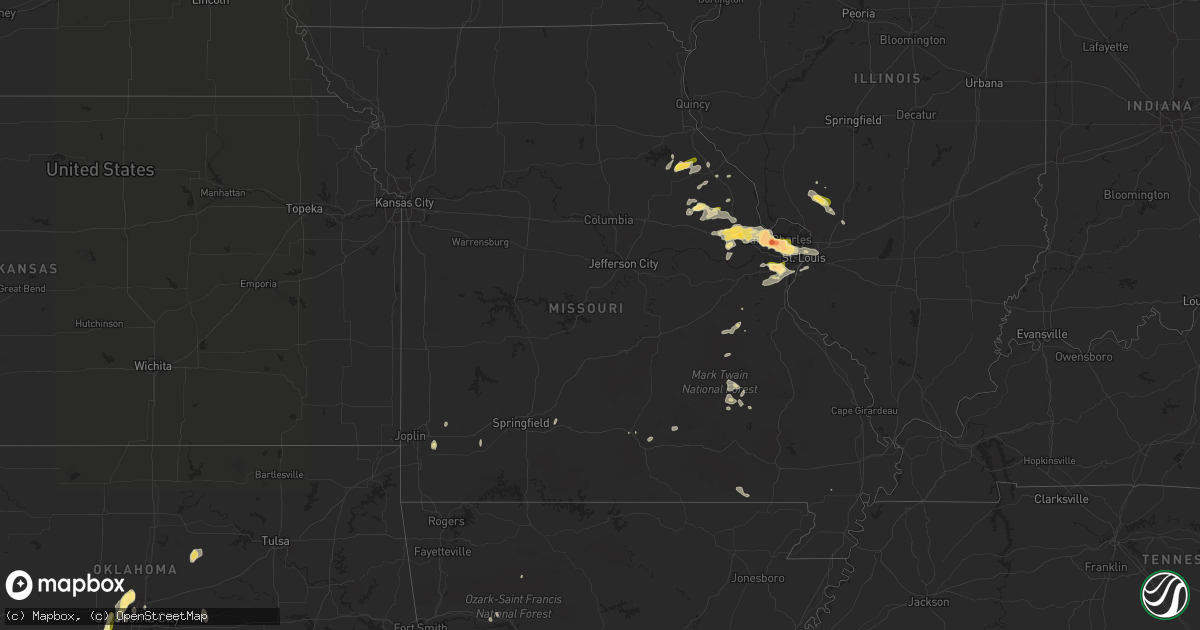
Hail Map in Missouri on May 13, 2023
Get this storm
May 13 map
$229
one time, instant access
Download today. No call, no setup
Keep the $229
Bought the map and want the full workflow? Apply the entire $229 to a subscription within 7 days. None of it is wasted.
Every map, not just this one
This buys you this map. Subscription and you get every map we run, in the markets you choose from a few cities to whole states to nationwide. Plus real-time alerts the moment a storm fires.
Contact data
Name, contact info, occupancy, even credit band for addresses in the footprint. You go from where it hit to who to call.
Become the source they trust
Unlimited branding weather history reports on demand. You already have the documented answer ready for the property owner, and you are the one who showed up with it.
Property data and RoofTrace estimates
Pull up any address you have got, its value and the exact code rules for that jurisdiction, straight from One Click Code. Then RoofTrace estimates the squares, pitch, and roof value, priced the way you price.
Storm reports in Missouri
Missouri
| Date | Description |
|---|---|
| 05/13/20233:29 PM CDT | Report from mping: half dollar |
| 05/13/20233:19 PM CDT | Report from mping: quarter |
| 05/13/20233:18 PM CDT | Report from mping: ping pong ball |
| 05/13/20233:12 PM CDT | Report from mping: ping pong ball |
| 05/13/20233:05 PM CDT | Delayed report. Photos submitted via social media. Between valley park and fenton. |
| 05/13/20233:04 PM CDT | Report from mping: quarter |
| 05/13/20233:02 PM CDT | Photos submitted via social media. Time estimated by radar. |
| 05/13/20233:02 PM CDT | A local report indicates 1.75 inch wind near 1 WSW VALLEY PARK |
| 05/13/20232:54 PM CDT | A local report indicates 1.50 inch wind near 1 NW PEERLESS PARK |
| 05/13/20232:53 PM CDT | A local report indicates 1.00 inch wind near 2 S MANCHESTER |
| 05/13/20232:51 PM CDT | A local report indicates 1.00 inch wind near 2 SSW MANCHESTER |
| 05/13/20232:50 PM CDT | A local report indicates 1.00 inch wind near 2 S MANCHESTER |
| 05/13/20232:38 PM CDT | Report from mping: quarter |
| 05/13/20232:38 PM CDT | Report from mping: quarter |
| 05/13/20232:37 PM CDT | Report from mping: quarter |
| 05/13/20232:32 PM CDT | Spotter also estimated wind to be near 50 mph. |
| 05/13/20232:21 PM CDT | A local report indicates 1.00 inch wind near 2 E MARYLAND HEIGHTS |
| 05/13/20232:19 PM CDT | A local report indicates 1.00 inch wind near 2 ENE MARYLAND HEIGHTS |
| 05/13/20232:19 PM CDT | Report from mping: hen egg+ |
| 05/13/20232:19 PM CDT | Report from mping: quarter |
| 05/13/20232:18 PM CDT | Report from mping: quarter |
| 05/13/20232:18 PM CDT | Report from mping: half dollar |
| 05/13/20232:17 PM CDT | A local report indicates 2.00 inch wind near SAINT CHARLES |
| 05/13/20232:16 PM CDT | A local report indicates 2.00 inch wind near 2 S SAINT CHARLES |
| 05/13/20232:16 PM CDT | Report from mping: quarter |
| 05/13/20232:16 PM CDT | A local report indicates 1.50 inch wind near 1 SSE BRIDGETON |
| 05/13/20232:16 PM CDT | Delayed report. Oblong hail measuring 3 inches at its widest. |
| 05/13/20232:15 PM CDT | Near i-70 east of the missouri river. |
| 05/13/20232:15 PM CDT | A local report indicates 2.50 inch wind near 2 SE SAINT CHARLES |
| 05/13/20232:15 PM CDT | A local report indicates 1.25 inch wind near MARYLAND HEIGHTS |
| 05/13/20232:14 PM CDT | Report from mping: hen egg |
| 05/13/20232:14 PM CDT | Spotter observed quarter sized hail and tree limbs down. Limbs are approximately 2-4 inches in diameter. |
| 05/13/20232:12 PM CDT | Photo submitted via social media. Time estimated by radar. |
| 05/13/20232:12 PM CDT | Report from mping: ping pong ball |
| 05/13/20232:11 PM CDT | A local report indicates 1.50 inch wind near 2 S SAINT CHARLES |
| 05/13/20232:11 PM CDT | Several photos with measurements submitted via social media. |
| 05/13/20232:10 PM CDT | A local report indicates 2.50 inch wind near 2 SE SAINT CHARLES |
| 05/13/20232:10 PM CDT | Report from mping: half dollar |
| 05/13/20232:10 PM CDT | A local report indicates 1.00 inch wind near 2 S SAINT CHARLES |
| 05/13/20232:09 PM CDT | Golf ball size hail was falling near the ameristar casino where i-70 crossed the missouri river. |
| 05/13/20232:09 PM CDT | Report from mping: half dollar |
| 05/13/20232:08 PM CDT | Update to earlier report hear hwy 364/hwy 94. |
| 05/13/20232:08 PM CDT | A local report indicates 1.50 inch wind near 2 S SAINT CHARLES |
| 05/13/20232:07 PM CDT | Report from mping: quarter |
| 05/13/20232:07 PM CDT | Report from mping: quarter |
| 05/13/20232:07 PM CDT | A local report indicates 1.25 inch wind near 2 SSW SAINT CHARLES |
| 05/13/20232:06 PM CDT | Report from mping: ping pong ball |
| 05/13/20232:06 PM CDT | A local report indicates 1.00 inch wind near 2 S SAINT CHARLES |
| 05/13/20232:06 PM CDT | Report from mping: quarter |
| 05/13/20232:04 PM CDT | Relayed report. |
| 05/13/20232:02 PM CDT | Report from mping: quarter |
| 05/13/20231:27 PM CDT | Spotter reported quarter size hail falling at the time of the call. |
| 05/13/202312:54 PM CDT | Photo submitted via social media. |
| 05/13/202312:53 PM CDT | Public photo submitted via social media. Time estimated by radar. |
| 05/13/202312:53 PM CDT | A local report indicates 1.25 inch wind near 3 WNW WENTZVILLE |
| 05/13/202312:50 PM CDT | Photo submitted via social media. Estimated due to odd shape of hail stone/lack of items to compare to within the photo. |
| 05/13/202312:50 PM CDT | A local report indicates 1.00 inch wind near 2 SW FLINT HILL |
| 05/13/202312:50 PM CDT | A local report indicates 1.00 inch wind near 1 NW WENTZVILLE |
| 05/13/202312:48 PM CDT | Hail size estimated. Slightly larger than several other photos received. |
| 05/13/202312:48 PM CDT | Report from mping: quarter |
All States Impacted by Hail Map on May 13, 2023
Cities Impacted by Hail Map on May 13, 2023
- Center, MO
- Perry, MO
- Vandalia, MO
- Bellflower, MO
- Montgomery City, MO
- Frankford, MO
- Middletown, MO
- Silex, MO
- Hawk Point, MO
- Wright City, MO
- Foristell, MO
- Wentzville, MO
- Williamsburg, IA
- Marengo, IA
- Indianola, IA
- Ackworth, IA
- Carlisle, IA
- Pleasantville, IA
- O'Fallon, MO
- Coralville, IA
- Iowa City, IA
- Bowling Green, MO
- Troy, MO
- Prole, IA
- Hedrick, IA
- Truxton, MO
- Fremont, IA
- Cedar, IA
- Kirkville, IA
- Eddyville, IA
- Ottumwa, IA
- Curryville, MO
- Warrenton, MO
- Moscow Mills, MO
- Truesdale, MO
- Jonesburg, MO
- High Hill, MO
- Parma, MO
- Clarksville, MO
- Saint Peters, MO
- Saint Charles, MO
- Saint Louis, MO
- Maryland Heights, MO
- Earth City, MO
- Bridgeton, MO
- Hazelwood, MO
- Saint Ann, MO
- Florissant, MO
- Ballwin, MO
- Valley Park, MO
- Eureka, MO
- High Ridge, MO
- Fenton, MO
- Gillespie, IL
- Shipman, IL
- Verden, OK
- Chickasha, OK
- Knoxville, IA
- Pella, IA
- Bunker Hill, IL
- Amber, OK
- Pocasset, OK
- Cumberland, VA
- Powhatan, VA
- Tuttle, OK
- Harvey, IA
- Minco, OK
- Worden, IL
- Staunton, IL
- Union City, OK
- Mustang, OK
- Newell, IA
- Leighton, IA
- Toccoa, GA
- Yukon, OK
- Oklahoma City, OK
- Edmond, OK
- Bethany, OK
- Pocahontas, IA
- Potosi, MO
- Wellsville, MO
- Wildwood, MO
- Centerville, MO
- Redford, MO
- El Reno, OK
- Lonedell, MO
- Richwoods, MO
- Medora, IL
- Millstadt, IL
- Dupo, IL
- East Saint Louis, IL
- Prague, OK
- Bourbon, MO
- Black, MO
- Lesterville, MO
- Sparks, OK
- O'Fallon, IL
- Van Meter, IA
- Piedmont, OK
- North English, IA
- South English, IA
- Lake Saint Louis, MO
- Imperial, MO
- Arnold, MO
- House Springs, MO
- Ninnekah, OK
- Cement, OK
- Alhambra, IL
- Henderson, TX
- Sullivan, MO
- Hartman, AR
- Piasa, IL
- Clarksville, AR
- Deer, AR
- Carlinville, IL
- Chesterfield, IL
- Keatchie, LA
- Grand Cane, LA
- Madison, IL
- Venice, IL
- Granite City, IL
- Collinsville, IL
- Granby, MO
- Diamond, MO
- Deming, NM
- Marthasville, MO
- Ripley, OK
- Cushing, OK
- Cabool, MO
- Aurora, MO
- Ellington, MO
- Shawnee, OK
- Meeker, OK
- Willow Springs, MO
- Reeds, MO
- Doniphan, MO
- Eminence, MO
- West Monroe, LA
- Chase City, VA
- Drakes Branch, VA
- Sarcoxie, MO
- Seymour, MO
- Fordland, MO
- Yale, OK
- Stillwater, OK
- Shreveport, LA
- Belleville, IL
- New Douglas, IL
- Parnell, IA
- Marshfield, MO
- East Carondelet, IL
- Conroy, IA
- Old Monroe, MO
- Lovejoy, IL
- Schaller, IA
- Golden Eagle, IL


