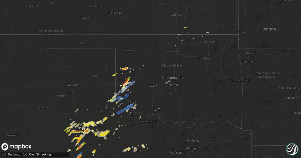
Hail Map in Oklahoma on May 13, 2020
Get this storm
May 13 map
$229
one time, instant access
Download today. No call, no setup
Keep the $229
Bought the map and want the full workflow? Apply the entire $229 to a subscription within 7 days. None of it is wasted.
Every map, not just this one
This buys you this map. Subscription and you get every map we run, in the markets you choose from a few cities to whole states to nationwide. Plus real-time alerts the moment a storm fires.
Contact data
Name, contact info, occupancy, even credit band for addresses in the footprint. You go from where it hit to who to call.
Become the source they trust
Unlimited branding weather history reports on demand. You already have the documented answer ready for the property owner, and you are the one who showed up with it.
Property data and RoofTrace estimates
Pull up any address you have got, its value and the exact code rules for that jurisdiction, straight from One Click Code. Then RoofTrace estimates the squares, pitch, and roof value, priced the way you price.
Storm reports in Oklahoma
Oklahoma
| Date | Description |
|---|---|
| 05/13/20206:53 PM CDT | Approximate location. |
| 05/13/20206:50 PM CDT | A local report indicates 1.50 inch wind near 3 S SAYRE |
| 05/13/20206:43 PM CDT | A local report indicates 1.00 inch wind near 3 SW REYDON |
| 05/13/20206:38 AM CDT | At 1138 PM CDT, a severe thunderstorm was located near Tuttle, moving northeast at 25 mph. HAZARD...60 mph wind gusts and quarter size hail. SOURCE...Radar indicated. IMPACT...Hail damage to vehicles is expected. Expect wind damage to roofs, siding, and trees. Locations impacted include... Oklahoma City, western Norman, Moore, Del City, Newcastle, Yukon, Bethany, Mustang, Warr Acres, The Village, Tuttle, Nichols Hills, Union City, Minco, Valley Brook, Bridge Creek and Woodlawn Park. |
| 05/13/20205:57 AM CDT | At 1057 PM CDT, a severe thunderstorm was located 4 miles southeast of Lockett, moving northeast at 40 mph. HAZARD...60 mph wind gusts and penny size hail. SOURCE...Radar indicated. IMPACT...Expect damage to roofs, siding, and trees. Locations impacted include... Vernon, Davidson, Lockett, Fargo, Oklaunion, Harrold, Grayback, Haynesville and Rayland. |
| 05/13/20204:44 AM CDT | At 944 PM CDT, a severe thunderstorm was located near Chillicothe, moving east at 35 mph. HAZARD...60 mph wind gusts and quarter size hail. SOURCE...Radar indicated. IMPACT...Hail damage to vehicles is expected. Expect wind damage to roofs, siding, and trees. Locations impacted include... Vernon, Tipton, Chillicothe, Davidson, Elmer, Headrick, Medicine Mound, Fargo, Humphreys, Odell, Oklaunion, Lockett, Hess and Rayland. |
| 05/13/20203:55 AM CDT | At 854 PM CDT, a severe thunderstorm was located 6 miles southwest of Angora, moving east at 20 mph. HAZARD...Golf ball size hail and 60 mph wind gusts. SOURCE...Radar indicated. IMPACT...People and animals outdoors will be injured. Expect hail damage to roofs, siding, windows, and vehicles. Expect wind damage to roofs, siding, and trees. Locations impacted include... Leedey, Camargo, Angora, Moorewood and Roll. |
| 05/13/20203:51 AM CDT | At 850 PM CDT, a severe thunderstorm was located 5 miles northwest of Carnegie, moving east at 40 mph. HAZARD...60 mph wind gusts. SOURCE...Radar indicated. IMPACT...Expect damage to roofs, siding, and trees. Locations impacted include... Anadarko, Carnegie, Cyril, Mountain View, Binger, Fort Cobb, Corn, Cement, Eakly, Gracemont, Gotebo, Lookeba, Colony, Cogar, Alfalfa, Cloud Chief, Fort Cobb Reservoir, Albert, Lake Chickasha and Cowden. |
| 05/13/20203:30 AM CDT | At 830 PM CDT, a severe thunderstorm was located 6 miles north of Chillicothe, moving northeast at 35 mph. HAZARD...60 mph wind gusts and nickel size hail. SOURCE...Radar indicated. IMPACT...Expect damage to roofs, siding, and trees. Locations impacted include... Tipton, Chillicothe, Olustee, Elmer, Fargo, Humphreys, Odell and Hess. |
| 05/13/20203:28 AM CDT | At 827 PM CDT, a severe thunderstorm was located near Burns Flat, moving northeast at 35 mph. HAZARD...60 mph wind gusts and quarter size hail. SOURCE...Radar indicated. IMPACT...Hail damage to vehicles is expected. Expect wind damage to roofs, siding, and trees. Locations impacted include... Weatherford, Clinton, Cordell, Burns Flat, Arapaho, Dill City, Canute, Corn, Bessie and Foss. |
| 05/13/20203:19 AM CDT | At 819 PM CDT, a severe thunderstorm was located near Roll, moving northeast at 25 mph. HAZARD...60 mph wind gusts and quarter size hail. SOURCE...Radar indicated. IMPACT...Hail damage to vehicles is expected. Expect wind damage to roofs, siding, and trees. Locations impacted include... Angora and Roll. |
| 05/13/20202:54 AM CDT | At 754 PM CDT, a severe thunderstorm was located 10 miles south of Goodlett, moving northeast at 40 mph. HAZARD...60 mph wind gusts and quarter size hail. SOURCE...Radar indicated. IMPACT...Hail damage to vehicles is expected. Expect wind damage to roofs, siding, and trees. Locations impacted include... Quanah, Goodlett and Lazare. |
| 05/13/20202:52 AM CDT | At 752 PM CDT, a severe thunderstorm was located near Carter, moving northeast at 40 mph. HAZARD...70 mph wind gusts and quarter size hail. SOURCE...Radar indicated. IMPACT...Hail damage to vehicles is expected. Expect considerable tree damage. Wind damage is also likely to mobile homes, roofs, and outbuildings. Locations impacted include... Elk City, Sayre, Cordell, Burns Flat, Dill City, Canute, Butler, Carter, Bessie, Foss, Foss Reservoir, Retrop and Stafford. |
| 05/13/20202:31 AM CDT | At 730 PM CDT, severe thunderstorms were located along a line extending from 9 miles northwest of Mangum to 10 miles northwest of Duke to 3 miles southwest of Gould to 9 miles north of Goodlett, moving east at 35 mph. HAZARD...70 mph wind gusts and ping pong ball size hail. SOURCE...Radar indicated. IMPACT...People and animals outdoors will be injured. Expect hail damage to roofs, siding, windows, and vehicles. Expect considerable tree damage. Wind damage is also likely to mobile homes, roofs, and outbuildings. Locations impacted include... Mangum, Granite, Sentinel, Blair, Eldorado, Lone Wolf, Martha, Willow, Gould, Retrop, Duke, Brinkman, Hester, McQueen and Altus-Lugert Lake. |
| 05/13/20202:20 AM CDT | At 720 PM CDT, a severe thunderstorm was located 6 miles north of Vinson, moving northeast at 45 mph. HAZARD...Golf ball size hail and 70 mph wind gusts. SOURCE...Radar indicated. IMPACT...People and animals outdoors will be injured. Expect hail damage to roofs, siding, windows, and vehicles. Expect considerable tree damage. Wind damage is also likely to mobile homes, roofs, and outbuildings. Locations impacted include... Sayre, Erick, Carter, Willow, Delhi and Brinkman. |
| 05/13/20201:51 AM CDT | At 651 PM CDT, a severe thunderstorm was located near Delhi, moving northeast at 30 mph. HAZARD...60 mph wind gusts and quarter size hail. SOURCE...Radar indicated. IMPACT...Hail damage to vehicles is expected. Expect wind damage to roofs, siding, and trees. Locations impacted include... Elk City, Sayre, Carter, Delhi and Berlin. |
| 05/13/20201:43 AM CDT | At 643 PM CDT, a severe thunderstorm was located 11 miles south of Wellington, moving northeast at 40 mph. HAZARD...60 mph wind gusts and half dollar size hail. SOURCE...Radar indicated. IMPACT...Minor damage to roofs, siding, and trees is possible. Hail damage to vehicles is expected. Locations impacted include... Wellington, Dodson, Dozier, Lutie, Quail and Samnorwood. |
| 05/13/20201:37 AM CDT | At 637 PM CDT, a severe thunderstorm was located 8 miles northwest of Childress, moving northeast at 55 mph. HAZARD...60 mph wind gusts and quarter size hail. SOURCE...Radar indicated. IMPACT...Hail damage to vehicles is expected. Expect wind damage to roofs, siding, and trees. Locations impacted include... Memphis and Kirkland. |
| 05/13/20201:32 AM CDT | At 632 PM CDT, a severe thunderstorm was located 4 miles east of Allison, moving northeast at 35 mph. HAZARD...Ping pong ball size hail and 60 mph wind gusts. SOURCE...Radar indicated. IMPACT...People and animals outdoors will be injured. Expect hail damage to roofs, siding, windows, and vehicles. Expect wind damage to roofs, siding, and trees. Locations impacted include... Cheyenne, Reydon, Strong City, Crawford, Roll and Durham. |
| 05/12/202011:54 PM CDT | Reported at 104th and s portland. |
| 05/12/202010:52 PM CDT | At 351 PM CDT, a severe thunderstorm was located 8 miles south of Alanreed, or 15 miles northeast of Clarendon, moving northeast at 25 mph. HAZARD...60 mph wind gusts and half dollar size hail. SOURCE...Radar indicated. IMPACT...Minor damage to roofs, siding, and trees is possible. Hail damage to vehicles is expected. Locations impacted include... Shamrock, Briscoe, Wheeler, Mclean, Lutie, New Mobeetie, Twitty, Lela, Samnorwood, Kellerville, Dozier, Alanreed and Mobeetie. |
| 05/12/20209:00 PM CDT | A local report indicates 1.75 inch wind near 4 WSW ANGORA |
| 05/12/20208:42 PM CDT | A local report indicates 1.50 inch wind near 3 N STRONG CITY |
| 05/12/20208:15 PM CDT | A local report indicates 58 MPH wind near 1 WSW BURNS FLAT |
| 05/12/20207:54 PM CDT | Also pea sized hail. |
| 05/12/20207:30 PM CDT | Time and location estimated from radar. Via social media. |
| 05/12/20207:12 PM CDT | Also small tree limbs broken. |
| 05/12/20207:10 PM CDT | A local report indicates 60 MPH wind near 1 W VINSON |
| 05/12/20207:10 PM CDT | A local report indicates 60 MPH wind near VINSON |
| 05/12/20207:09 PM CDT | A local report indicates 1.00 inch wind near ELK CITY |
| 05/12/20207:08 PM CDT | Time and location estimated from radar. |
| 05/12/20207:02 PM CDT | A local report indicates 60 MPH wind near 4 W HOLLIS |
All States Impacted by Hail Map on May 13, 2020
Cities Impacted by Hail Map on May 13, 2020
- Mountain Home, TX
- Ralls, TX
- Graham, TX
- Breckenridge, TX
- South Bend, TX
- Encino, TX
- Roaring Springs, TX
- Snyder, TX
- Lubbock, TX
- Carter, OK
- Hunter, OK
- Childress, TX
- Iraan, TX
- Wolfforth, TX
- Dryden, TX
- Ransom Canyon, TX
- Slaton, TX
- Hollis, OK
- Wellington, TX
- Dodson, TX
- Albany, TX
- Uvalde, TX
- Fort Stockton, TX
- Rocksprings, TX
- Wamego, KS
- Belvue, KS
- Dickens, TX
- Gouldbusk, TX
- Lamesa, TX
- Welch, TX
- Paducah, TX
- Odessa, TX
- Goldsmith, TX
- Spur, TX
- Comstock, TX
- Elk City, OK
- Leakey, TX
- Grandfalls, TX
- Ozona, TX
- Zapata, TX
- Hebbronville, TX
- Leedey, OK
- Crowell, TX
- Seymour, TX
- Plainview, TX
- Mangum, OK
- San Ygnacio, TX
- Guerra, TX
- Abernathy, TX
- Lueders, TX
- Soldier, KS
- Tipton, OK
- Headrick, OK
- Sayre, OK
- Cheyenne, OK
- Frederick, OK
- Crosbyton, TX
- Gail, TX
- Holton, KS
- Andrews, TX
- Coyanosa, TX
- Silverton, TX
- Jayton, TX
- Girard, TX
- Hamburg, IA
- Idalou, TX
- Lorenzo, TX
- Ackerly, TX
- Dorchester, NE
- Westmoreland, KS
- Onaga, KS
- Blackwell, OK
- Braman, OK
- Axtell, KS
- Frankfort, KS
- Eldorado, OK
- Gould, OK
- Afton, TX
- Bern, KS
- Seneca, KS
- Savannah, MO
- Baileyville, KS
- Monahans, TX
- Mcadoo, TX
- Floydada, TX
- Aspermont, TX
- Willow, OK
- Newkirk, OK
- Elmer, OK
- Comanche, OK
- Abilene, TX
- Bennet, NE
- Palmyra, NE
- Briscoe, TX
- Centralia, KS
- Del Rio, TX
- Mayetta, KS
- Granite, OK
- Odell, TX
- Vernon, TX
- Chillicothe, TX
- Oklahoma City, OK
- Gardendale, TX
- Hanover, KS
- Barnes, KS
- Washington, KS
- Greenleaf, KS
- Linn, KS
- Post, TX
- Wilson, TX
- Tahoka, TX
- Shallowater, TX
- Bethany, MO
- Hammon, OK
- Olsburg, KS
- Butler, OK
- Crane, TX
- Abilene, KS
- Chapman, KS
- Wakefield, KS
- Ponca City, OK
- Barksdale, TX
- Erick, OK
- Armstrong, TX
- Duke, OK
- New Deal, TX
- Odonnell, TX
- Caney, KS
- Niotaze, KS
- Havana, KS
- Electra, TX
- Lenorah, TX
- Powhattan, KS
- Horton, KS
- Emmett, KS
- Tuttle, OK
- Pine Ridge, SD
- Matador, TX
- Effingham, KS
- Cummings, KS
- Goff, KS
- Circleville, KS
- Gracemont, OK
- Denver, MO
- Albany, MO
- Delia, KS
- Geronimo, OK
- Quanah, TX
- Denton, KS
- Carbon, IN
- Rockville, IN
- Brazil, IN
- Anadarko, OK
- Martell, NE
- Roca, NE
- Lincoln, NE
- Havensville, KS
- Kress, TX
- Rochester, TX
- Bremen, KS
- Tarzan, TX
- Dill City, OK
- Sentinel, OK
- Vinson, OK
- Oakwood, OK
- Camp Wood, TX
- Pawhuska, OK
- Eola, TX
- Knott, TX
- Muscotah, KS
- Valley Falls, KS
- Woodson, TX
- Greencastle, IN
- Darlington, MO
- King City, MO
- Clay Center, KS
- Altus, OK
- Levelland, TX
- Dunbar, NE
- Winfield, KS
- Newcastle, OK
- Mustang, OK
- Saint Joseph, MO
- De Kalb, MO
- Tonkawa, OK
- Billings, OK
- Custer, SD
- Throckmorton, TX
- Canute, OK
- Crawford, OK
- Custer City, OK
- Harrold, TX
- Temple, OK
- Fort Cobb, OK
- Rushville, MO
- Midland, TX
- Lenox, IA
- Gravity, IA
- Saint Marys, KS
- Shidler, OK
- Union Star, MO
- Lindsay, OK
- Falls City, NE
- Syracuse, NE
- Hickman, NE
- Arkansas City, KS
- Turney, MO
- Cameron, MO
- Ropesville, TX
- Smyer, TX
- Reydon, OK
- Foss, OK
- Olustee, OK


