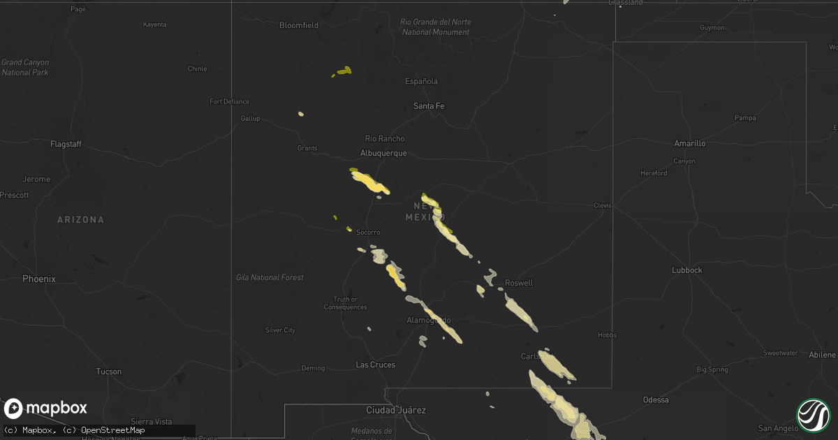
Hail Map in New Mexico on May 13, 2012
Get this storm
May 13 map
$229
one time, instant access
Download today. No call, no setup
Keep the $229
Bought the map and want the full workflow? Apply the entire $229 to a subscription within 7 days. None of it is wasted.
Every map, not just this one
This buys you this map. Subscription and you get every map we run, in the markets you choose from a few cities to whole states to nationwide. Plus real-time alerts the moment a storm fires.
Contact data
Name, contact info, occupancy, even credit band for addresses in the footprint. You go from where it hit to who to call.
Become the source they trust
Unlimited branding weather history reports on demand. You already have the documented answer ready for the property owner, and you are the one who showed up with it.
Property data and RoofTrace estimates
Pull up any address you have got, its value and the exact code rules for that jurisdiction, straight from One Click Code. Then RoofTrace estimates the squares, pitch, and roof value, priced the way you price.
Storm reports in New Mexico
New Mexico
| Date | Description |
|---|---|
| 05/13/20124:15 PM CDT | Trees down off highway 107 |
| 05/13/20123:04 PM CDT | A local report indicates 1.00 inch wind near 1 W MAGDALENA |
| 05/13/20123:00 PM CDT | Structures hit on sw side of town. |
| 05/12/20129:15 PM CDT | A local report indicates 1.00 inch wind near WHITES CITY |
| 05/12/20128:45 PM CDT | Relayed by sheriffs office. Person from telephone canyon near sacramento nm reported 0.50 inch to 1.00 inch hail during tstm. |
| 05/12/20128:41 PM CDT | Nickle increasing to quarter size hail. Highway 285 and 137. |
| 05/12/20128:30 PM CDT | A local report indicates 1.00 inch wind near 2 SSE CLOUDCROFT |
| 05/12/20128:20 PM CDT | At us 285 and county rd 21 |
| 05/12/20128:19 PM CDT | Nickle to quarter size hail covering the ground. |
| 05/12/20128:19 PM CDT | A local report indicates 60 MPH wind near 8 S ARTESIA |
| 05/12/20127:55 PM CDT | A local report indicates 62 MPH wind near 2 W ARTESIA |
| 05/12/20127:53 PM CDT | White sands missile range - phillips hill. |
| 05/12/20127:52 PM CDT | Spotter reported hail the size of quarters in mountain park |
| 05/12/20127:25 PM CDT | A local report indicates 1.25 inch wind near 1 ENE TULAROSA |
Cities Impacted by Hail Map on May 13, 2012
- Salem, AL
- Opelika, AL
- Barstow, TX
- Pecos, TX
- Dryden, TX
- Smiths Station, AL
- Sacramento, NM
- Las Cruces, NM
- Lake Arthur, NM
- Artesia, NM
- Luverne, AL
- Eufaula, AL
- Carlsbad, NM
- Loving, NM
- Belen, NM
- Jarales, NM
- Los Lunas, NM
- Bosque, NM
- Van Horn, TX
- Truth Or Consequences, NM
- Socorro, NM
- Brantley, AL
- Fort Davis, TX
- Georgetown, GA
- Tuskegee, AL
- Salt Flat, TX
- Westcliffe, CO
- Alamogordo, NM
- Kenton, OK
- Bluffton, GA
- Edison, GA
- Panama City, FL
- Panama City Beach, FL
- Coyanosa, TX
- La Luz, NM
- High Rolls Mountain Park, NM
- Canon City, CO
- Blakely, GA
- Fort Gaines, GA
- Dexter, NM
- Roswell, NM
- Hagerman, NM
- Tinnie, NM
- Las Animas, CO
- Picacho, NM
- Magdalena, NM
- Marathon, TX
- Crownpoint, NM
- Thoreau, NM
- Willard, NM
- Fort Stockton, TX
- Cloudcroft, NM
- Capitan, NM
- Branson, CO
- Brundidge, AL
- Alpine, TX
- Corona, NM
- Trinidad, CO
- Freeport, FL
- Imperial, TX
- Sheffield, TX
- Balmorhea, TX
- Pyote, TX
- Mentone, TX
- Clayton, AL
- Hurtsboro, AL
- Columbus, GA
- Fortson, GA
- Auburn, AL
- Tularosa, NM
- Carrizozo, NM
- Dell City, TX
- Evergreen, AL
- Weed, NM
- Pinon, NM
- Des Moines, NM
- Midway, AL
- Tallahassee, FL
- Alexander City, AL
- Eclectic, AL
- Union Springs, AL
- Youngstown, FL
- Santa Rosa Beach, FL
- Veguita, NM
- Mayhill, NM
- Banks, AL
- Tallassee, AL
- Ebro, FL
- Ponce De Leon, FL
- Vernon, FL
- Inlet Beach, FL
- Troy, AL
- Louisville, AL
- Florissant, CO
- Weston, CO
- Vona, CO
- Dulce, NM
- Cuba, NM


