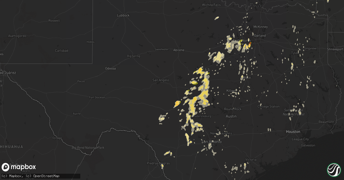
Hail Map in Texas on May 12, 2014
Get this storm
May 12 map
$229
one time, instant access
Download today. No call, no setup
Keep the $229
Bought the map and want the full workflow? Apply the entire $229 to a subscription within 7 days. None of it is wasted.
Every map, not just this one
This buys you this map. Subscription and you get every map we run, in the markets you choose from a few cities to whole states to nationwide. Plus real-time alerts the moment a storm fires.
Contact data
Name, contact info, occupancy, even credit band for addresses in the footprint. You go from where it hit to who to call.
Become the source they trust
Unlimited branding weather history reports on demand. You already have the documented answer ready for the property owner, and you are the one who showed up with it.
Property data and RoofTrace estimates
Pull up any address you have got, its value and the exact code rules for that jurisdiction, straight from One Click Code. Then RoofTrace estimates the squares, pitch, and roof value, priced the way you price.
Storm reports in Texas
Texas
| Date | Description |
|---|---|
| 05/12/20145:32 PM CDT | A local report indicates 1.75 inch wind near 9 N JUNCTION |
| 05/12/20145:24 PM CDT | Large tree limbs down. |
| 05/12/20145:09 PM CDT | A local report indicates 1.00 inch wind near 10 NE CLEO |
| 05/12/20144:50 PM CDT | Large tree limbs down. |
| 05/12/20144:41 PM CDT | A local report indicates 1.75 inch wind near 10 NE CLEO |
| 05/12/20144:12 PM CDT | Damage to fire station 10 in plano to one of its doors |
| 05/12/20144:02 PM CDT | Golfball hail joe pool lake |
| 05/12/20144:02 PM CDT | A local report indicates 2.00 inch wind near MANSFIELD |
| 05/12/20144:00 PM CDT | Deputy reported ping pong ball size hail near the intersection of fm 386 and fm 2618 |
| 05/12/20143:53 PM CDT | North plano |
| 05/12/20143:50 PM CDT | Half dollar size hail in mansfield |
| 05/12/20143:49 PM CDT | Quart size hail covering the ground |
| 05/12/20143:40 PM CDT | Mcdermott and custer in plano |
| 05/12/20143:17 PM CDT | Quarter size hail in crowley |
| 05/12/20143:10 PM CDT | Quart size hail in west ft worth |
| 05/12/20142:58 PM CDT | At the corner of 7th and cypress street |
| 05/12/20142:15 PM CDT | Quarter size hail reported along 84e between early and zephyr |
| 05/12/20141:55 PM CDT | A local report indicates 1.00 inch wind near BROWNWOOD |
| 05/12/20141:49 PM CDT | A local report indicates 1.50 inch wind near 3 NE EARLY |
| 05/12/20141:38 PM CDT | A local report indicates 1.25 inch wind near 3 NE EARLY |
| 05/12/201412:59 PM CDT | A local report indicates 1.25 inch wind near 1 ENE BANGS |
| 05/12/201412:13 AM CDT | A few tree limbs down. |
| 05/11/20148:14 PM CDT | Wind damage to a roof at hwy 8 and county road 1238 intersection. |
| 05/11/20147:56 PM CDT | Trees and powerlines were downed in the price community. |
| 05/11/20147:45 PM CDT | Received report from kltv meteorologist via facebook of trees down on county road 26 between tyler and kilgore. |
| 05/11/20147:45 PM CDT | Trees down on fm 747 south in the pierces chapel area. |
| 05/11/20147:45 PM CDT | Several large trees downed in kilgore... One tree fell on top of a carport on lantrip street off of hwy. 259. Another tree fell across a fence in town. Trees were also |
| 05/11/20147:40 PM CDT | Trees downed across hwy. 135 near jacksonville as well as on cr 3305 and one on kilo monument road and on fm 177. |
| 05/11/20147:40 PM CDT | A few trees down on fm 747 north... About 6 miles from hwy 79. |
| 05/11/20147:29 PM CDT | Trees were downed on old hwy. 135. |
| 05/11/20147:18 PM CDT | Quarter size hail with very heavy rain. 1.00 inch over the last 45 minutes. |
All States Impacted by Hail Map on May 12, 2014
Cities Impacted by Hail Map on May 12, 2014
- May, TX
- Brownwood, TX
- Blanket, TX
- Early, TX
- Bangs, TX
- Zephyr, TX
- Winfield, IA
- Elkins, AR
- Krum, TX
- Rocksprings, TX
- Weatherford, TX
- Ardmore, OK
- Republic, MO
- Dierks, AR
- Spragueville, IA
- Bellevue, IA
- Caldwell, TX
- Bryan, TX
- Goliad, TX
- Boonville, IN
- Justin, TX
- Rock City, IL
- Dakota, IL
- Freeport, IL
- Sumner, MO
- Allerton, IA
- Clio, IA
- Edgerton, WI
- Goodman, MO
- Neosho, MO
- Burlington, WI
- Arlington, TX
- Grand Prairie, TX
- Lometa, TX
- Glenwood, AR
- Caddo Gap, AR
- Norman, AR
- Langley, AR
- Mount Vernon, MO
- Stotts City, MO
- Miller, MO
- Liberty, IL
- Camp Point, IL
- Saltillo, TX
- Dike, TX
- Alexandria, MO
- Eufaula, OK
- Hanna, OK
- Roscoe, IL
- South Beloit, IL
- Rockton, IL
- West Bend, WI
- Jackson, WI
- Kirksville, MO
- Keota, OK
- Hico, TX
- La Pryor, TX
- La Grange, MO
- Novelty, MO
- Evansville, IN
- Henderson, KY
- D Hanis, TX
- Medina, TX
- Utopia, TX
- Jacksonville, TX
- Sun Prairie, WI
- Madison, WI
- Samson, AL
- Lake Forest, IL
- Highland Park, IL
- Deerfield, IL
- New Franklin, MO
- Lockridge, IA
- Mount Pleasant, IA
- Flemington, MO
- Watertown, WI
- Grantville, GA
- Hogansville, GA
- Hext, TX
- Amherst, OH
- Vermilion, OH
- Rochelle, TX
- Verona, WI
- Blue Mounds, WI
- Mount Horeb, WI
- Barneveld, WI
- Hollandale, WI
- Linn Creek, MO
- Montreal, MO
- San Saba, TX
- Miami, OK
- Quapaw, OK
- Dyer, TN
- Rutherford, TN
- Laredo, TX
- Milwaukee, WI
- Belleville, WI
- Johnson Creek, WI
- Comfort, TX
- Center Point, TX
- Ringwood, IL
- Wonder Lake, IL
- Aquilla, TX
- Menard, TX
- Junction, TX
- London, TX
- Gilmer, TX
- Bloomfield, IA
- Wayland, IA
- Birmingham, IA
- Fairfield, IA
- Downing, MO
- Douds, IA
- Lancaster, MO
- Stockport, IA
- Milton, IA
- Pulaski, IA
- Keosauqua, IA
- De Leon, TX
- Ranger, TX
- Desdemona, TX
- Ashton, IL
- Llano, TX
- Fort Atkinson, WI
- Cambridge, WI
- Jefferson, WI
- Franklin, TX
- North Chicago, IL
- Great Lakes, IL
- Lake Bluff, IL
- Dansville, MI
- Marionville, MO
- Billings, MO
- Clever, MO
- Leesville, LA
- Basco, IL
- West Point, IL
- Carthage, IL
- Plainwell, MI
- Muskego, WI
- Marengo, IL
- Palmyra, MO
- Fulton, MO
- Columbia, MO
- Sharon, WI
- Montrose, IA
- Keokuk, IA
- Quemado, TX
- Brackettville, TX
- San Antonio, TX
- Avalon, WI
- Beloit, WI
- Clinton, WI
- Pecatonica, IL
- Winnebago, IL
- Janesville, WI
- German Valley, IL
- Rockford, IL
- Oak Creek, WI
- South Milwaukee, WI
- Boerne, TX
- Defuniak Springs, FL
- Ponce De Leon, FL
- Spickard, MO
- Frost, TX
- Bensenville, IL
- Elk Grove Village, IL
- Wood Dale, IL
- Itasca, IL
- Lone Tree, IA
- Palmyra, WI
- Oconomowoc, WI
- Milton, WI
- New Berlin, WI
- Lake Mills, WI
- Dousman, WI
- Helenville, WI
- Wales, WI
- Delafield, WI
- North Prairie, WI
- Sullivan, WI
- Whitewater, WI
- Eagle, WI
- Mukwonago, WI
- Waukesha, WI
- Boynton, OK
- Oktaha, OK
- Council Hill, OK
- Harper, TX
- Mountain Home, TX
- Round Lake, IL
- Lake Villa, IL
- Grayslake, IL
- Cedar Hill, TX
- Mansfield, TX
- Hondo, TX
- Brooklyn, WI
- Nacogdoches, TX
- Kerrville, TX
- Poolville, TX
- Bandera, TX
- Pipe Creek, TX
- Elm Grove, WI
- Brookfield, WI
- Oglesby, IL
- Peru, IL
- Cedar Point, IL
- La Salle, IL
- Machesney Park, IL
- Caledonia, IL
- Loves Park, IL
- Leslie, MI
- Rives Junction, MI
- Farmington, AR
- Prairie Grove, AR
- Valley City, OH
- Medina, OH
- Brunswick, OH
- Noel, MO
- Mason, TX
- Mayville, WI
- Brownsville, WI
- Lomira, WI
- Campbellsport, WI
- Fond Du Lac, WI
- Kingdom City, MO
- Iowa City, IA
- Kingsland, TX
- Lake Geneva, WI
- Elkhorn, WI
- Delavan, WI
- Ingram, TX
- Camdenton, MO
- Big Sandy, TX
- Newtown, MO
- Milan, MO
- Harris, MO
- Sylvania, OH
- Scroggins, TX
- Grafton, OH
- Litchfield, OH
- Trenton, MO
- Lock Springs, MO
- Gallatin, MO
- Jamesport, MO
- Kidder, MO
- Hamilton, MO
- Williams Bay, WI
- Walworth, WI
- Granbury, TX
- Winnetka, IL
- Northbrook, IL
- Glencoe, IL
- Glenview, IL
- Osco, IL
- Cambridge, IL
- La Belle, MO
- Lewistown, MO
- Mountainburg, AR
- Alma, AR
- Alvarado, TX
- Venus, TX
- Richland Springs, TX
- Woodway, TX
- Crawford, TX
- China Spring, TX
- McGregor, TX
- Kingston, OK
- Bonifay, FL
- New Braunfels, TX
- Cresson, TX
- Freeport, MI
- Lowell, MI
- Clarksville, MI
- Alto, MI
- Salado, TX
- Von Ormy, TX
- Stephenville, TX
- Bluff Dale, TX
- Dublin, TX
- Grove, OK
- Greentop, MO
- Waco, TX
- Falkner, MS
- Hawkins, TX
- Brady, TX
- Kenedy, TX
- Washington, IA
- Keota, IA
- Stockton, IA
- Everton, MO
- Walnut Grove, MO
- Melvin, TX
- Walnut Springs, TX
- Centerville, TX
- Oakwood, TX
- Clark, MO
- Verona, MO
- Aurora, MO
- Poplar Grove, IL
- Lampasas, TX
- Mullin, TX
- Waldron, AR
- Warsaw, IL
- Sturgeon, MO
- Deerfield, WI
- Talihina, OK
- Juda, WI
- Seguin, TX
- Pleasant Hope, MO
- Milan, MI
- Heber Springs, AR
- Orion, IL
- Long Branch, TX
- Carthage, TX
- Sonora, TX
- Colgate, WI
- Hartland, WI
- Blackwater, MO
- Nelson, MO
- Belton, TX
- Fort Hood, TX
- Ash Grove, MO
- Reeseville, WI
- Willard, MO
- Bois D Arc, MO
- Greenwood, AR
- Dundee, MI
- Monroe, MI
- Perryville, AR
- Revere, MO
- Kahoka, MO
- Wayland, MO
- Stendal, IN
- Mena, AR
- Sturtevant, WI
- Cameron, MO
- Doss, TX
- Geneseo, IL
- De Kalb, TX
- Prophetstown, IL
- Erie, IL
- Martin, MI
- Kansas, OK
- Oaks, OK
- Rusk, TX
- Henrietta, TX
- Franklin Grove, IL
- Amboy, IL
- Dixon, IL
- Fort Polk, LA
- Conway, MO
- Pontotoc, TX
- Valley Spring, TX
- Cherokee, TX
- Victoria, TX
- Lamar, MO
- Jasper, MO
- Union, IL
- Henderson, TX
- Laneville, TX
- Tishomingo, OK
- Mill Creek, OK
- Mannsville, OK
- Madill, OK
- West Branch, IA
- Lineville, IA
- Corydon, IA
- Millerton, IA
- Mercer, MO
- Granby, MO
- Stark City, MO
- Fort Worth, TX
- Crowley, TX
- Farber, MO
- Axtell, TX
- Temple, TX
- Afton, IA
- Charleston, MO
- Anacoco, LA
- Willis, MI
- Rio Vista, TX
- Lott, TX
- Charlestown, IN
- Marysville, IN
- Richfield, OH
- North Ridgeville, OH
- Cuyahoga Falls, OH
- Columbia Station, OH
- Avon, OH
- Huron, OH
- Berea, OH
- Collins, OH
- Peninsula, OH
- Cleveland, OH
- Sheffield Lake, OH
- Lagrange, OH
- Lorain, OH
- Hudson, OH
- Strongsville, OH
- Akron, OH
- Oberlin, OH
- Wakeman, OH
- Elyria, OH
- Berlin Heights, OH
- North Royalton, OH
- Kipton, OH
- Wellington, OH
- Stow, OH
- Seville, OH
- Spencer, OH
- Hinckley, OH
- Chippewa Lake, OH
- Lodi, OH
- Olmsted Falls, OH
- North Olmsted, OH
- Wadsworth, OH
- Broadview Heights, OH
- Westlake, OH
- Magazine, AR
- Denton, TX
- Argyle, TX
- Mineral Wells, TX
- Pewaukee, WI
- Libertyville, IL
- Letts, IA
- Leonard, MO
- Kellerton, IA
- Lamoni, IA
- Decatur, IA
- Hatfield, MO
- Lipan, TX
- East Troy, WI
- Fredericksburg, TX
- Stoughton, WI
- Keller, TX
- Scottsburg, IN
- Conroe, TX
- Ashland, MO
- New Bloomfield, MO
- Lebanon, MO
- Lena, IL
- Kent, IL
- Westville, FL
- Springdale, AR
- Fayetteville, AR
- Joshua, TX
- Burleson, TX
- Salem, WI
- Paris, MO
- Cleburne, TX
- Buckholts, TX
- Piggott, AR
- Bunceton, MO
- Skidmore, TX
- Elkhart, TX
- Palestine, TX
- Clifton, TX
- Whitney, TX
- Valley Mills, TX
- Brookesmith, TX
- Santa Anna, TX
- Turney, MO
- Fredonia, TX
- Art, TX
- De Queen, AR
- Claremore, OK
- Holdenville, OK
- Helotes, TX
- West, TX
- Elm Mott, TX
- Abbott, TX
- Hunt, TX
- Mansfield, OH
- Aledo, IL
- Chana, IL
- Rochelle, IL
- Union Grove, WI
- Racine, WI
- Jasper, IN
- Livingston, TX
- Goodrich, TX
- Florence, MO
- Jefferson City, MO
- Holts Summit, MO
- Truro, IA
- Saint Charles, IA
- Chilton, TX
- Shannon, IL
- Forreston, IL
- Baileyville, IL
- Seymour, IA
- Comanche, TX
- Goldthwaite, TX
- Decatur, TX
- Ponder, TX
- Rhome, TX
- Warsaw, MO
- Galt, MO
- Unionville, MO
- Pollock, MO
- Cambridge, OH
- New Concord, OH
- Higbee, MO
- Deer, AR
- Kansasville, WI
- Allen, OK
- Pea Ridge, AR
- Seligman, MO
- Pineville, MO
- Harrisburg, MO
- Fayette, MO
- New Waverly, TX
- Willis, TX
- Bynum, TX
- Florala, AL
- Rector, AR
- Corning, AR
- Irving, TX
- Fair Grove, MO
- Strafford, MO
- Andalusia, AL
- Larue, TX
- Frankston, TX
- Mertens, TX
- Cannelburg, IN
- Montgomery, IN
- Washington, IN
- Loogootee, IN
- Solon, IA
- Hemphill, TX
- Blanco, TX
- Tivoli, TX
- Bangor, MI
- Bloomingdale, MI
- Barrington, IL
- Ingleside, IL
- Antioch, IL
- Wauconda, IL
- Fox Lake, IL
- Columbus Junction, IA
- Midlothian, TX
- Marshall, AR
- Leslie, AR
- Salisbury, MO
- Glasgow, MO
- Coldspring, TX
- Pointblank, TX
- Mineral Point, WI
- Cleveland, TX
- Vanderpool, TX
- Tarpley, TX
- Castell, TX
- Leakey, TX
- Kinston, AL
- Hillsboro, TX
- Morrisville, MO
- Wapello, IA
- Morning Sun, IA
- Wetumpka, AL
- Bowen, IL
- Augusta, IL
- Golden, IL
- Pinckney, MI
- Gregory, MI
- Rushville, IL
- Hodgen, OK
- Harvard, IL
- Garden Prairie, IL
- Mexico, MO
- Stockbridge, MI
- Webberville, MI
- Howell, MI
- Madison, MO
- Eldridge, IA
- Long Grove, IA
- Tuscumbia, MO
- Cassville, MO
- Locust Grove, OK
- Winnsboro, TX
- Lohn, TX
- Ewing, MO
- Loraine, IL
- Nashville, AR
- Hornersville, MO
- Leachville, AR
- Russell, IA
- Chariton, IA
- Florien, LA
- Athens, TX
- Ransom, IL
- Newland, NC
- Linville, NC
- Twin Lakes, WI
- Fairland, OK
- Bluejacket, OK
- Afton, OK
- Vinita, OK
- Okemah, OK
- Blum, TX
- Colcord, OK
- Arcola, MO
- Greenfield, MO
- Arp, TX
- Overton, TX
- Genoa City, WI
- Burlington, IA
- Sperry, IA
- Hennessey, OK
- Hamilton, IL
- Nauvoo, IL
- Mount Ida, AR
- Huntington, AR
- Auxvasse, MO
- Midland, PA
- East Liverpool, OH
- Industry, PA
- Georgetown, PA
- Newell, WV
- Wellsville, OH
- Spiro, OK
- Kennedale, TX
- Sulphur, OK
- Rosendale, MO
- Savannah, MO
- Mendon, IL
- Quincy, IL
- Coal Valley, IL
- Colona, IL
- Welch, OK
- Chetopa, KS
- Stella, MO
- Meridian, TX
- Buffalo, MO
- Eucha, OK
- Jay, OK
- Malone, TX
- Floresville, TX
- Whitesboro, TX
- Russellville, MO
- Maybee, MI
- Clinton, IA
- Bryant, IA
- South Greenfield, MO
- Montalba, TX
- Exeter, MO
- Sedalia, MO
- Hughesville, MO
- Eagle Pass, TX
- Centertown, MO
- Armstrong, MO
- Marshall, WI
- Waterloo, WI
- Woodstock, IL
- Sandusky, OH
- Cole Camp, MO
- Thomson, IL
- Springfield, WI
- Tahlequah, OK
- Horton, KS
- Sauk City, WI
- Huntsville, MO
- Clifton Hill, MO
- Gibson, IA
- Deep River, IA
- Erie, MI
- Haslet, TX
- Gotebo, OK
- Fairview, MO
- Purdy, MO
- Cotulla, TX
- Cedarburg, WI
- Grafton, WI
- Lufkin, TX
- Pollok, TX
- Anderson, MO
- Lanark, IL
- Wilmette, IL
- Shelbina, MO
- Paoli, IN
- Pilot Grove, MO
- Kopperl, TX
- Shelbyville, MO
- Hopkins, MI
- Crockett, TX
- Kent, OH
- Ravenna, OH
- Rootstown, OH
- Huntington, TX
- Leon, IA
- Henley, MO
- Italy, TX
- Deridder, LA
- Stockton, MO
- Paron, AR
- Valley View, TX
- Era, TX
- Ottawa Lake, MI
- Sealy, TX
- Floris, IA
- Brighton, IA
- Mount Union, IA
- Glenwood, MO
- Olds, IA
- Muskogee, OK
- Pleasant Lake, MI
- Fowler, IL
- Lorena, TX
- Moody, TX
- Fair Play, MO
- Mequon, WI
- Kennard, TX
- Haworth, OK
- Holland, TX
- Muscatine, IA
- Beeville, TX
- Barberton, OH
- Clinton, OH
- Doylestown, OH
- Richland, IA
- Gentry, AR
- Siloam Springs, AR
- Washburn, MO
- Poteau, OK
- Davenport, IA
- Manila, AR
- Gustine, TX
- Lockwood, MO
- Jerico Springs, MO
- Belmont, WI
- Dodgeville, WI
- New Boston, IL
- Deforest, WI
- Morrisonville, WI
- Arlington, WI
- Dexter, MI
- Summers, AR
- Lincoln, AR
- Milton, KY
- Grapeland, TX
- Denver, MO
- Garden Grove, IA
- Weldon, IA
- Grant City, MO
- Hamilton, TX
- Pottsville, TX
- Azle, TX
- Springtown, TX
- Dubois, IN
- Mansfield, LA
- Galesburg, IL
- Quanah, TX
- Ore City, TX
- McCausland, IA
- Lake Zurich, IL
- Mount Prospect, IL
- Arlington Heights, IL
- Niles, IL
- Bloomingdale, IL
- Glen Ellyn, IL
- Vernon Hills, IL
- Des Plaines, IL
- Highwood, IL
- Glendale Heights, IL
- Lincolnshire, IL
- Park Ridge, IL
- Buffalo Grove, IL
- Addison, IL
- Wheeling, IL
- Lombard, IL
- Mundelein, IL
- Morton Grove, IL
- Prospect Heights, IL
- Mangum, OK
- Sabinal, TX
- Lillian, TX
- Keene, TX
- Wadsworth, IL
- Gurnee, IL
- Waukegan, IL
- Argyle, WI
- South Wayne, WI
- Seneca, MO
- Milan, IL
- Moline, IL
- Rock Island, IL
- Columbus, WI
- Beaver Dam, WI
- Springport, MI
- Parma, MI
- Onondaga, MI
- Jackson, MI
- Mason, MI
- Fowlerville, MI
- New Glarus, WI
- Symsonia, KY
- Earlville, IL
- Brumley, MO
- Promise City, IA
- Plano, IA
- Mystic, IA
- Corder, MO
- Higginsville, MO
- Dover, MO
- Middleton, WI
- Waunakee, WI
- Cross Plains, WI
- Hulbert, OK
- Brownstown, IN
- Adair, OK
- Princeton, MO
- Altus, OK
- Duke, OK
- Blair, OK
- North Liberty, IA
- Tiffin, IA
- Gainesville, TX
- Rocky Comfort, MO
- Jourdanton, TX
- Weleetka, OK
- Annawan, IL
- Pitkin, LA
- Forest Hill, LA
- Lecompte, LA
- Parks, AR
- Rubicon, WI
- Neosho, WI
- Springfield, MO
- Portland, MO
- Jessieville, AR
- Carthage, MO
- Brighton, MI
- Walcott, IA
- Dixon, IA
- Donahue, IA
- Blooming Grove, TX
- Darien, WI
- Charleston, AR
- Fort Smith, AR
- Booneville, AR
- Munith, MI
- Grass Lake, MI
- Chouteau, OK
- West Point, IA
- Donnellson, IA
- Fort Madison, IA
- Lynn Center, IL
- Andover, IL
- Madison, IN
- Hanover, IN
- Fort Gibson, OK
- Monroe, WI
- Sanger, TX
- Glenmora, LA
- Golden City, MO
- Crawfordsville, IA
- Queen City, MO
- Danville, IA
- Metamora, OH
- Berkey, OH
- Delta, OH
- Swanton, OH
- Iron Ridge, WI
- Hustisford, WI
- Juneau, WI
- Selma, IA
- Martin, TN
- Randolph, WI
- Fall River, WI
- Flower Mound, TX
- Roanoke, TX
- California, MO
- Boonville, MO
- Calamus, IA
- Pangburn, AR
- Germantown, WI
- Richfield, WI
- Hubertus, WI
- Valley Falls, KS
- Maywood, MO
- Capron, IL
- Elizabethton, TN
- Brodhead, WI
- Orfordville, WI
- Durand, IL
- Davis, IL
- Poteet, TX
- Somerset, TX
- Muscotah, KS
- Silver Lake, WI
- Trevor, WI
- Hastings, MI
- Paradise, TX
- Otterville, MO
- Memphis, MO
- Castroville, TX
- Zapata, TX
- Guerra, TX
- Belvidere, IL
- Trenton, TN
- Kenton, TN
- Grandview, TX
- Milburn, OK
- Hebron, IL
- Richmond, IL
- Fontana, WI
- Kenosha, WI
- Bristol, WI
- Wilmot, WI
- Mulberry, AR
- Gibbs, MO
- La Plata, MO
- Elgin, IL
- South Elgin, IL
- Stockton, IL
- Marshfield, MO
- Saint Patrick, MO
- Willow City, TX
- Mount Carroll, IL
- Sussex, WI
- Lexington, IN
- Blissfield, MI
- Cardwell, MO
- Batavia, IA
- Packwood, IA
- Spavinaw, OK
- Oxford Junction, IA
- Smithville, OK
- Lake Odessa, MI
- Davis Junction, IL
- Holcomb, IL
- Milford, TX
- Newark, MO
- Huntingburg, IN
- New London, IA
- Wever, IA
- Shepherd, TX
- Sinton, TX
- Odem, TX
- Ben Wheeler, TX
- Barnes City, IA
- Philadelphia, MO
- Rosebud, TX
- Williamsburg, IA
- Vickery, OH
- Joy, IL
- Columbus, TX
- Stonewall, OK
- Ada, OK
- Quincy, MO
- Oregon, WI
- Troup, TX
- French Lick, IN
- English, IN
- Nolanville, TX
- Harker Heights, TX
- Killeen, TX
- Crystal City, TX
- Sigourney, IA
- Harper, IA
- San Marcos, TX
- Newburgh, IN
- Chandler, IN
- Brashear, MO
- Fremont, OH
- Petoskey, MI
- Phillipsburg, MO
- Marshallville, OH
- Sterling, OH
- Rittman, OH
- Slinger, WI
- Hartford, WI
- Newnan, GA
- Columbus, KS
- Baxter Springs, KS
- Delton, MI
- Gould, OK
- Eldorado, OK
- Plattsburg, MO
- Mediapolis, IA
- Apple Springs, TX
- Curtice, OH
- Senath, MO
- Oxford, IA
- Winona, TX
- Lathrop, MO
- Eagleville, MO
- Gentry, MO
- Qulin, MO
- Campbell, MO
- Pleasanton, TX
- Hanover, IL
- Penelope, TX
- Hubbard, TX
- Maquoketa, IA
- Golden, MS
- Aledo, TX
- Tolar, TX
- Godley, TX
- Millsap, TX
- Schertz, TX
- Itasca, TX
- Murfreesboro, AR
- Paducah, KY
- Bella Vista, AR
- Bentonville, AR
- Canton, MO
- Sutter, IL
- Moore, TX
- Monroe Center, IL
- Tipton, IA
- Madisonville, TX
- Spring, TX
- Franklin, MO
- Syracuse, MO
- Tipton, MO
- Preston, MS
- Orleans, IN
- Campbellsburg, IN
- Malakoff, TX
- Martinsburg, MO
- Milano, TX
- Gause, TX
- Perry, AR
- Gladewater, TX
- Kalamazoo, MI
- Sherrard, IL
- Konawa, OK
- Kingsbury, TX
- Peggs, OK
- Allenton, WI
- Cat Spring, TX
- Iredell, TX
- Kempner, TX
- Monroe City, MO
- Quaker City, OH
- Wyandotte, OK
- Meadville, PA
- Menomonee Falls, WI
- Ashippun, WI
- Mcfarland, WI
- Evansville, WI
- Lebanon, WI
- Ixonia, WI
- Cottage Grove, WI
- Leaf River, IL
- Ridott, IL
- Clyman, WI
- Sandwich, IL
- Wagoner, OK
- Livonia, MO
- Exline, IA
- Moulton, IA
- Clarksville, AR
- Ozone, AR
- Troy, AL
- Sidney, TX
- Pickton, TX
- Payson, IL
- Hull, IL
- Plainville, IL
- Farmington, IA
- Dawn, MO
- Sulphur Springs, AR
- Gravette, AR
- Elberfeld, IN
- Monticello, MO
- La Prairie, IL
- Union City, TN
- Rives, TN
- Salem, IN
- Shoals, IN
- Hobart, OK
- Elkland, MO
- Clayton, IL
- Zanesville, OH
- Checotah, OK
- Chillicothe, MO
- Carrollton, TX
- Dallas, TX
- Mount Vernon, TX
- Salem, KY
- Bonnerdale, AR
- Onalaska, TX
- West Olive, MI
- Zeeland, MI
- Goshen, AL
- Pleasant Prairie, WI
- New Boston, TX
- Round Rock, TX
- Mount Calm, TX
- Kilgore, TX
- Saukville, WI
- Burnet, TX
- Riverside, IA
- De Witt, IA
- Wyaconda, MO
- Montgomery City, MO
- Worth, MO
- Derby, IA
- Humeston, IA
- Unicoi, TN
- Erwin, TN
- Calvert, TX
- Toledo, OH
- Temperance, MI
- Franklin, WI
- Caledonia, WI
- Franksville, WI
- Schaumburg, IL
- Westville, OK
- Wentworth, MO
- Sevierville, TN
- Groesbeck, TX
- Devine, TX
- Bigfoot, TX
- Lytle, TX
- Natalia, TX
- Webb City, MO
- Oronogo, MO
- Prairie Hill, TX
- Jacksboro, TX
- Clarence, MO
- Holliday, MO
- Warren, IL
- Winslow, IL
- Atkinson, IL
- Jbsa Ft Sam Houston, TX
- Saint Hedwig, TX
- Marion, TX
- Monticello, WI
- Rio Medina, TX
- Eldridge, MO
- Tracy, IA
- Dawson, TX
- Murray, IA
- Thayer, IA
- Melber, KY
- Boaz, KY
- Roselle, IL
- Refugio, TX
- Atascosa, TX
- Ypsilanti, MI
- Ann Arbor, MI
- Lake Dallas, TX
- Oregon, MO
- Wayland, MI
- New London, MO
- Winslow, AR
- West Fork, AR
- Bethel, MO
- Saint Charles, IL
- Wasco, IL
- Foreman, AR
- Eagle, MI
- Eugene, MO
- Fulton, KY
- South Fulton, TN
- Windsor, MO
- Lucerne, MO
- Santo, TX
- Palo Pinto, TX
- Mansfield, AR
- Diboll, TX
- Braymer, MO
- Tyler, TX
- La Salle, MI
- Ida, MI
- McConnell, IL
- Orangeville, IL
- Horicon, WI


