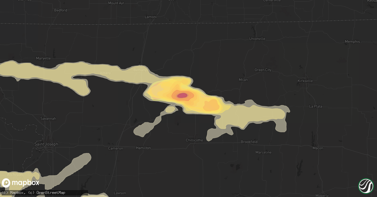
Hail Map in Trenton, MO on May 10, 2014
Get this storm
May 10 map
$229
one time, instant access
Download today. No call, no setup
Keep the $229
Bought the map and want the full workflow? Apply the entire $229 to a subscription within 7 days. None of it is wasted.
Every map, not just this one
This buys you this map. Subscription and you get every map we run, in the markets you choose from a few cities to whole states to nationwide. Plus real-time alerts the moment a storm fires.
Contact data
Name, contact info, occupancy, even credit band for addresses in the footprint. You go from where it hit to who to call.
Become the source they trust
Unlimited branding weather history reports on demand. You already have the documented answer ready for the property owner, and you are the one who showed up with it.
Property data and RoofTrace estimates
Pull up any address you have got, its value and the exact code rules for that jurisdiction, straight from One Click Code. Then RoofTrace estimates the squares, pitch, and roof value, priced the way you price.
Storm reports in Trenton, MO
Trenton, MO
| Date | Description |
|---|---|
| 05/10/20145:24 PM CDT | A local report indicates 2.75 inch wind near NW TRENTON |
| 05/10/20145:20 PM CDT | A local report indicates 2.50 inch wind near TRENTON |
| 05/10/20145:17 PM CDT | A local report indicates 2.75 inch wind near 3 W TRENTON |
| 05/10/20145:13 PM CDT | A local report indicates 2.00 inch wind near BRIMSON |
| 05/10/20145:10 PM CDT | Reported near crowder state park. Power lines also reported down in west trenton at 515pm. |
| 05/10/20144:49 PM CDT | A local report indicates 1.75 inch wind near 4 WNW TRENTON |
All States Impacted by Hail Map on May 10, 2014
All Cities Impacted by Hail Map on May 10, 2014
- Kearney, MO
- Trimble, MO
- Holt, MO
- Smithville, MO
- Albany, MO
- Elsberry, MO
- Eolia, MO
- Clarksville, MO
- Annada, MO
- Viola, KS
- Granite City, IL
- Atchison, KS
- New Hampton, MO
- Bethany, MO
- Stanberry, MO
- Hendley, NE
- Admire, KS
- Reading, KS
- Emporia, KS
- Allen, KS
- Stoutsville, MO
- Monroe City, MO
- Perry, MO
- Center, MO
- Alma, NE
- McLouth, KS
- Leavenworth, KS
- Easton, KS
- Malta Bend, MO
- Glen Carbon, IL
- De Kalb, MO
- Edgar, NE
- Lenora, KS
- Holdrege, NE
- Orleans, NE
- Agra, KS
- Minden, NE
- Campbell, NE
- Wilcox, NE
- Almena, KS
- Stamford, NE
- Prairie View, KS
- Phillipsburg, KS
- Kenesaw, NE
- Bloomington, NE
- Riverton, NE
- Hildreth, NE
- Franklin, NE
- Kensington, KS
- Republican City, NE
- Bladen, NE
- Long Island, KS
- Norton, KS
- Upland, NE
- Holstein, NE
- Naponee, NE
- Heartwell, NE
- Valentines, VA
- Emporia, VA
- Lawrenceville, VA
- Gasburg, VA
- Gloucester, VA
- Abilene, KS
- Hamilton, KS
- Eureka, KS
- Edgerton, MO
- Lake City, IA
- Owensboro, KY
- Rockport, IN
- Kidder, MO
- Altamont, MO
- Gallatin, MO
- Jasper, IN
- Gypsum, KS
- Solomon, KS
- Griswold, IA
- Lewis, IA
- Wiota, IA
- Atlantic, IA
- South Boston, VA
- Linneus, MO
- Purdin, MO
- Browning, MO
- Fairfield, NE
- Deweese, NE
- Glenvil, NE
- Topeka, KS
- Tecumseh, KS
- Berryton, KS
- Everest, KS
- Green Bay, VA
- Rice, VA
- Harned, KY
- Hudson, KY
- Winfield, KS
- Rock, KS
- Liberty, MO
- Orrick, MO
- Excelsior Springs, MO
- Hampton, NE
- Aurora, NE
- Robinson, KS
- Hiawatha, KS
- Leon, KS
- Latham, KS
- Canby, MN
- Madison, MN
- Dawson, MN
- Boyd, MN
- Lebanon, KS
- Smith Center, KS
- Red Cloud, NE
- Harvard, NE
- Burrton, KS
- Hutchinson, KS
- Medicine Lodge, KS
- Isabel, KS
- Cedar Point, KS
- Williamsburg, MO
- Steedman, MO
- Nelson, MO
- Ashland, MO
- Slater, MO
- Glasgow, MO
- Henrietta, MO
- Independence, MO
- Troy, MO
- Harrisburg, MO
- Fayette, MO
- Jonesburg, MO
- Kansas City, KS
- Hermann, MO
- Corder, MO
- Boonville, MO
- Dover, MO
- Columbia, MO
- Benton City, MO
- Norborne, MO
- Carrollton, MO
- Warrenton, MO
- Kingdom City, MO
- Lexington, MO
- Miami, MO
- Montgomery City, MO
- Hardin, MO
- Sibley, MO
- Auxvasse, MO
- New Florence, MO
- Camden, MO
- Fulton, MO
- Rhineland, MO
- Marshall, MO
- New Franklin, MO
- Missouri City, MO
- Franklin, MO
- Rocheport, MO
- Mokane, MO
- Marthasville, MO
- Waverly, MO
- Wright City, MO
- Riverside, MO
- Blackwater, MO
- Gilliam, MO
- New Bloomfield, MO
- Arrow Rock, MO
- Chamois, MO
- Kansas City, MO
- Martinsburg, MO
- Truesdale, MO
- Richmond, MO
- Portland, MO
- Wooldridge, MO
- Tebbetts, MO
- Meriden, KS
- Oskaloosa, KS
- Wakarusa, KS
- Winchester, KS
- Valley Falls, KS
- Ozawkie, KS
- Grantville, KS
- Perry, KS
- Stuart, IA
- Clearwater, KS
- Taswell, IN
- Dubois, IN
- Paoli, IN
- French Lick, IN
- Milltown, IN
- Marengo, IN
- English, IN
- Hardinsburg, IN
- Birdseye, IN
- Eckerty, IN
- Celestine, IN
- Independence, VA
- Brookings, SD
- Bruce, SD
- Toronto, SD
- Henderson, KY
- Thompson, MO
- Mexico, MO
- Augusta, KS
- Virgil, KS
- El Dorado, KS
- Yates Center, KS
- Edwardsville, IL
- Roxana, IL
- South Roxana, IL
- Wood River, IL
- Hartford, IL
- Americus, KS
- Partridge, KS
- Moundridge, KS
- South Hutchinson, KS
- Buhler, KS
- Doniphan, NE
- Frankford, MO
- Curryville, MO
- Bowling Green, MO
- New London, MO
- Vandalia, MO
- Laredo, MO
- Leitchfield, KY
- Big Clifty, KY
- Auburn, KS
- Lecompton, KS
- Freeman, VA
- Wheeling, MO
- Chula, MO
- Barnard, MO
- Jameson, MO
- New Boston, MO
- Jamesport, MO
- Gilman City, MO
- Graham, MO
- Maitland, MO
- Brookfield, MO
- Fairfax, MO
- Conception Junction, MO
- Craig, MO
- Gentry, MO
- Hamilton, MO
- Trenton, MO
- Galt, MO
- Skidmore, MO
- McFall, MO
- Winigan, MO
- Conception, MO
- Clyde, MO
- Ravenwood, MO
- Mound City, MO
- Maryville, MO
- Spickard, MO
- Elmer, MO
- Meadville, MO
- Laclede, MO
- Bucklin, MO
- Coffey, MO
- Ethel, MO
- Milan, MO
- King City, MO
- New Cambria, MO
- Darlington, MO
- Humphreys, MO
- Guilford, MO
- Oberlin, KS
- Macon, MO
- Clarence, MO
- Anabel, MO
- Winfield, MO
- Blue Rapids, KS
- Wichita, KS
- Valley Center, KS
- Rosalia, KS
- Clifton Hill, MO
- Higbee, MO
- Armstrong, MO
- Fieldon, IL
- Atlanta, KS
- Douglass, KS
- Lentner, MO
- Shelbina, MO
- Madison, MO
- Holliday, MO
- Dearborn, MO
- Santa Fe, MO
- Paris, MO
- Circleville, KS
- Sellersburg, IN
- Jeffersonville, IN
- Clarksville, IN
- New Albany, IN
- Floyds Knobs, IN
- Hastings, NE
- Shoals, IN
- Nelson, NE
- Fairmont, NE
- Geneva, NE
- Ong, NE
- McCool Junction, NE
- York, NE
- Shickley, NE
- Grafton, NE
- Oak, NE
- Sutton, NE
- Battletown, KY
- Leavenworth, IN
- Gravity, IA
- Lancaster, KS
- Cummings, KS
- Cheney, KS
- Kingman, KS
- Norwich, KS
- Milton, KS
- Clay Center, KS
- Green, KS
- Longford, KS
- Callao, MO
- Greenville, IN
- Louisville, KY
- Borden, IN
- Prospect, KY
- Charlestown, IN
- Pekin, IN
- Palmyra, IN
- Diagonal, IA
- Tingley, IA
- Shannon City, IA
- Roseland, NE
- Holton, KS
- Wetmore, KS
- Whiting, KS
- Netawaka, KS
- Saint Charles, MO
- Saint Peters, MO
- Clay Center, NE
- Mankato, KS
- Burr Oak, KS
- Fontanelle, IA
- Aurelia, IA
- Alta, IA
- Norfolk, VA
- Fort Monroe, VA
- Loogootee, IN
- Wellsville, MO
- Bellflower, MO
- Truxton, MO
- Middletown, MO
- Laddonia, MO
- Rush Hill, MO
- Silex, MO
- Farber, MO
- Hawk Point, MO
- Norcatur, KS
- Wilsonville, NE
- Lebanon, NE
- Wellington, KS
- Oxford, KS
- Udall, KS
- Belle Plaine, KS
- Farmville, VA
- Meherrin, VA
- Soldier, KS
- Fort Leavenworth, KS
- New Market, IA
- Lawrence, NE
- Saronville, NE
- Henderson, NE
- Guide Rock, NE
- Blue Hill, NE
- Giltner, NE
- Pelham, NC
- Ringgold, VA
- Virgilina, VA
- Alton, VA
- Danville, VA
- Providence, NC
- Sutherlin, VA
- Milton, NC
- Hardin, IL
- Foley, MO
- Batchtown, IL
- Excello, MO
- Scandia, KS
- Fairbury, NE
- Jamestown, KS
- Reynolds, NE
- Belleville, KS
- Munden, KS
- Narka, KS
- Agenda, KS
- Mahaska, KS
- Cuba, KS
- Concordia, KS
- Lenox, IA
- Clearfield, IA
- Bedford, IA
- Sharpsburg, IA
- Rockwell City, IA
- Garden Plain, KS
- Goddard, KS
- Cape Charles, VA
- Alton, IL
- West Alton, MO
- Maryville, IL
- Moro, IL
- Bethalto, IL
- East Alton, IL
- Cottage Hills, IL
- Godfrey, IL
- Troy, IL
- Harveyville, KS
- Burlingame, KS
- Welda, KS
- Colony, KS
- Westphalia, KS
- Middlefield, CT
- Meriden, CT
- Middletown, CT
- Rockfall, CT
- Balaton, MN
- Ruthton, MN
- Esbon, KS
- Ellston, IA
- Corydon, KY
- Olpe, KS
- Strong City, KS
- Cottonwood Falls, KS
- Matfield Green, KS
- Mulvane, KS
- Endicott, NE
- Alhambra, IL
- Worden, IL
- Mount Vernon, IN
- Beaver City, NE
- Oxford, NE
- Winslow, IN
- Oakland City, IN
- Bridgewater, IA
- Juniata, NE
- Plattsburg, MO
- Stewartsville, MO
- Gower, MO
- Agency, MO
- Portage Des Sioux, MO
- Dow, IL
- Jerseyville, IL
- Osborn, MO
- Cameron, MO
- Turney, MO
- Scranton, KS
- Osage City, KS
- Carbondale, KS
- Massena, IA
- Greenfield, IA
- Anita, IA
- Toronto, KS
- Sparta, NC
- Mouth Of Wilson, VA
- Cannelburg, IN
- Dexter, IA
- Earlham, IA
- Winterset, IA
- Van Meter, IA
- Prole, IA
- Norwalk, IA
- Nortonville, KS
- Inman, KS
- Palmyra, IL
- Burkeville, VA
- Evansville, IN
- Spottsville, KY
- Reed, KY
- Uniontown, KY
- New Haven, IL
- Hollenberg, KS
- Odell, NE
- Centralia, MO
- Effingham, KS
- Muscotah, KS
- Horton, KS
- Weston, MO
- Rushville, MO
- Platte City, MO
- Hartford, KY
- Beaver Dam, KY
- Washington, KS
- Trumbull, NE
- Salisbury, MO
- Inavale, NE
- Haysville, KS
- Grafton, IL
- Western, NE
- Daykin, NE
- Swanton, NE
- Wilber, NE
- Saint Anthony, IN
- Huntingburg, IN
- Atlanta, MO
- Robinson, IL
- Andover, KS
- Rose Hill, KS
- Towanda, KS
- Windsor, VA
- Smithfield, VA
- Portis, KS
- Gaylord, KS
- Cannelton, IN
- Tell City, IN
- Verdon, NE
- Oakland, IA
- Hancock, IA
- Mitchell, IN
- Burns, KS
- Cassoday, KS
- Potwin, KS
- Bremen, KS
- Marysville, KS
- Alexandria, KY
- California, KY
- Evanston, IN
- Troy, IN
- Cowgill, MO
- Dawn, MO
- Braymer, MO
- Newport News, VA
- Hampton, VA
- Depauw, IN
- Ferdinand, IN
- Schnellville, IN
- High Hill, MO
- O'Fallon, MO
- Wentzville, MO
- Nashville, KS
- Carrollton, VA
- Hardinsburg, KY
- Hamburg, IL
- Piedmont, KS
- Fall River, KS
- Foristell, MO
- Defiance, MO
- Lake Saint Louis, MO
- Suffolk, VA
- Severy, KS
- Sturgeon, MO
- Memphis, IN
- Glenview, KY
- Grand Island, NE
- Ayr, NE
- Phillips, NE
- Francisco, IN
- Elliott, IA
- Staunton, IL
- Bunker Hill, IL
- Gillespie, IL
- Gary, SD
- Huntsville, MO
- Cairo, MO
- Tobias, NE
- Milligan, NE
- Beaumont, KS
- Howard, KS
- Manchester, KY
- Brandt, SD
- Clark, MO
- Morganfield, KY
- Shawneetown, IL
- Somers, IA
- Lawson, MO
- Falls Of Rough, KY
- Golden Eagle, IL
- Chillicothe, MO
- Axtell, NE
- Capron, VA
- Friend, NE
- Dorchester, NE
- Brighton, IL
- Bevier, MO
- Otwell, IN
- Petersburg, IN
- Washington, IN
- Montgomery, IN
- Yale, IL
- Correctionville, IA
- Cushing, IA
- Hubbell, NE
- Norway, KS
- Beloit, KS
- Waverly, KY
- Superior, NE
- Saint Joseph, MO
- Conway Springs, KS
- Neal, KS
- Gridley, KS
- Derby, KS
- Mcconnell Afb, KS
- Benton, KS
- Peck, KS
- Greenup, IL
- Eden, NC
- Ivanhoe, MN
- Hallsville, MO
- Brussels, IL
- Walnut, IA
- Breckenridge, MO
- Clear Lake, SD
- Newton, IL
- Ruffin, NC
- Holstein, IA
- Quimby, IA
- Washta, IA
- Toledo, IL
- Morrowville, KS
- Mcpherson, KS
- Zenda, KS
- Rome, IN
- Lamar, IN
- Derby, IN
- Jacksonville, MO
- Whitewater, KS
- Baskerville, VA
- South Hill, VA
- Collinsville, IL
- Florissant, MO
- Elsah, IL
- Saint Elmo, IL
- Bethelridge, KY
- Yosemite, KY
- Martin, TN
- Sedley, VA
- Wakefield, VA
- Moberly, MO
- Roodhouse, IL
- Hartsburg, MO
- Willow Hill, IL
- Murdock, KS
- Bristow, IN
- Spivey, KS
- Georgetown, IN
- Goshen, KY
- Bruning, NE
- Strang, NE
- Princeton, IN
- Randolph, KS
- Cunningham, KS
- Wood River, NE
- North, VA
- Greenleaf, KS
- Denton, KS
- Altamont, IL
- Utica, KY
- Havelock, IA
- Laurens, IA
- Moscow Mills, MO
- Strasburg, VA
- Garfield, KY
- Grantsburg, IN
- Jewett, IL
- Montrose, IL
- Carlinville, IL
- Shipman, IL
- Charlotte, NC
- Harrisburg, NC
- Gaffney, SC
- Hunnewell, MO
- Faucett, MO
- Denison, KS


